Bridge Statistics for Dickinson, New York (NY)
Condition, Traffic, Stress, Structural Evaluation, Project Costs
- National Bridge Inventory (NBI) Statistics
- 11Number of bridges
- 72ft / 22.0mTotal length
- $22,240,000Total costs
- 209,927Total average daily traffic
- 8,194Total average daily truck traffic
- National Bridge Inventory (NBI) Registered Bridges for Dickinson
- No street view available for this location
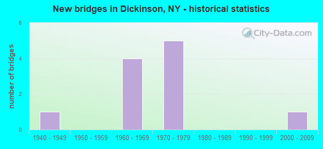
- New bridges - historical statistics
- 11940-1949
- 41960-1969
- 51970-1979
- 12000-2009


- Bridge Condition - Deck
- 25.0%Good
- 25.0%Satisfactory
- 50.0%Fair

- Bridge Condition - Superstructure
- 25.0%Good
- 75.0%Satisfactory

- Bridge Condition - Substructure
- 50.0%Satisfactory
- 25.0%Fair
- 25.0%Poor

- Bridge Condition - Channel
- 33.3%Good
- 33.3%Satisfactory
- 33.3%Fair

- Bridge Condition - Culverts
- 50.0%Good
- 50.0%Satisfactory
Find on map >> Show street view
Structure Number: 100819, Location: .6 MI N INT5 I-81 ON RT11 (Lat: 42.124322, Lng: -75.905950), Route carried "on" structure: US 11, Year Built: 1966, Status: Open, Structure Length: 11.03m (36.19ft), Average Daily Traffic: 7,193 (year 2020), Truck Traffic: 4%, Average Future Daily Traffic: 8,738 (year 2040), Design Load: HS 20+Mod, Features Intersected: 81 81 91013004 NB, RTE
Minimum Vertical Clearance: 30+ m (98+ ft), Kilometerpoint: 23.668, Lanes on structure: 3, Lanes under structure: 8, Base Highway Network: Yes, Owner: State Highway Agency, Approaching Roadway Width: 19.5m (64.0ft), Skew: 3 degrees, Material/Design: Steel, Design/Construction: Stringer/Multi-beam, Number Of Spans In Main Unit: 6, Length of Maximum Span: 22.2m (72.8ft), Curb-To-Curb Width: 16.4m (53.8ft), Out-to-Out Width: 17.4m (57.1ft)
Condition: Deck: Satisfactory, Superstructure: Satisfactory, Substructure: Poor, Operating Rating: 74.2 metric tons, Method Used To Determine Operating Rating: Load and Resistance Factor Rating (LRFR) rating reported by rating factor(RF) method using HL-93 loadings, Inventory Rating: 57.0 metric tons, Method Used To Determine Inventory Rating: Load and Resistance Factor Rating (LRFR) rating reported by rating factor(RF) method using HL-93 loadings, Structural Evaluation: Meets minimum limits, Deck Geometry: Better than present minimum criteria, Underclear: High priority of corrective action, Approach Roadway Alignment: Equal to present desirable criteria, Length Of Structure Improvement: 11.03m (36.19ft), Designated Inspection Frequency: Every 24 months, Inspection Date: June 2021, Bridge Improvement Cost: $4,099,000, Roadway Improvement Cost: $2,401,000, Total Project Cost: $6,500,000 ( Estimate for 2021), Deck Structure Type: Concrete Cast-file-Place, Wearing Surface/Protective System: Wearing Surface: Monolithic Concrete
Find on map >> Show street view
Structure Number: 1063229, Location: 1.2 MI E JCT RTS 17 + 201 (Lat: 42.119956, Lng: -75.945936), Route carried "on" structure: State highway 17, Year Built: 1971, Status: Open, Structure Length: 3.90m (12.80ft), Average Daily Traffic: 52,780 (year 2015), Truck Traffic: 10%, Average Future Daily Traffic: 61,161 (year 2040), Design Load: HS 20+Mod, Features Intersected: CR 69
Minimum Vertical Clearance: 30+ m (98+ ft), Kilometerpoint: 15.109, Lanes on structure: 8, Lanes under structure: 6, Base Highway Network: Yes, Owner: State Highway Agency, Approaching Roadway Width: 37.5m (123.0ft), Skew: 21 degrees, Material/Design: Steel, Design/Construction: Stringer/Multi-beam, Number Of Spans In Main Unit: 1, Length of Maximum Span: 37.7m (123.7ft), Curb-To-Curb Width: 34.4m (112.9ft), Out-to-Out Width: 37.2m (122.0ft)
Condition: Deck: Fair, Superstructure: Satisfactory, Substructure: Satisfactory, Operating Rating: 35.6 metric tons, Method Used To Determine Operating Rating: Load and Resistance Factor Rating (LRFR) rating reported by rating factor(RF) method using HL-93 loadings, Inventory Rating: 27.5 metric tons, Method Used To Determine Inventory Rating: Load and Resistance Factor Rating (LRFR) rating reported by rating factor(RF) method using HL-93 loadings, Structural Evaluation: Equal to present minimum criteria, Deck Geometry: Somewhat better than minimum adequacy, Underclear: Somewhat better than minimum adequacy, Approach Roadway Alignment: Equal to present desirable criteria, Length Of Structure Improvement: 3.90m (12.80ft), Designated Inspection Frequency: Every 24 months, Inspection Date: July 2021, Bridge Improvement Cost: $4,698,000, Roadway Improvement Cost: $2,751,000, Total Project Cost: $7,450,000 ( Estimate for 2021), Deck Structure Type: Concrete Cast-file-Place, Wearing Surface/Protective System: Wearing Surface: Bituminous, Membrane: Other
Find on map >> Show street view
Structure Number: 1063239, Location: 1.5 MI E JCT RTS 17 + 201 (Lat: 42.117208, Lng: -75.940583), Route carried "on" structure: State highway 17, Year Built: 1971, Year Reconstructed: 2016, Status: Open, Structure Length: 3.90m (12.80ft), Average Daily Traffic: 45,967 (year 2015), Truck Traffic: 4%, Average Future Daily Traffic: 53,266 (year 2040), Design Load: HS 20+Mod, Features Intersected: GLENWOOD ROAD
Minimum Vertical Clearance: 30+ m (98+ ft), Kilometerpoint: 15.656, Lanes on structure: 6, Lanes under structure: 2, Base Highway Network: Yes, Owner: State Highway Agency, Approaching Roadway Width: 30.5m (100.1ft), Skew: 22 degrees, Material/Design: Steel, Design/Construction: Stringer/Multi-beam, Number Of Spans In Main Unit: 1, Length of Maximum Span: 37.4m (122.7ft), Curb-To-Curb Width: 28.7m (94.2ft), Out-to-Out Width: 30.5m (100.1ft)
Condition: Deck: Fair, Superstructure: Satisfactory, Substructure: Satisfactory, Operating Rating: 86.2 metric tons, Method Used To Determine Operating Rating: Load Factor (LF), Inventory Rating: 50.8 metric tons, Method Used To Determine Inventory Rating: Load Factor (LF), Structural Evaluation: Equal to present minimum criteria, Deck Geometry: Better than present minimum criteria, Underclear: Meets minimum limits, Approach Roadway Alignment: Equal to present desirable criteria, Length Of Structure Improvement: 3.90m (12.80ft), Designated Inspection Frequency: Every 24 months, Inspection Date: November 2020, Bridge Improvement Cost: $4,058,000, Roadway Improvement Cost: $2,377,000, Total Project Cost: $6,435,000 ( Estimate for 2021), Deck Structure Type: Concrete Cast-file-Place, Wearing Surface/Protective System: Wearing Surface: Latex Concrete
Find on map >> Show street view
Structure Number: 334966, Location: .5 MILE N OF JOHNSON CITY (Lat: 42.127100, Lng: -75.944831), Route carried "on" structure: County highway , Year Built: 1942, Status: Open, Structure Length: 1.43m (4.69ft), Average Daily Traffic: 1,851 (year 2016), Truck Traffic: 3%, Average Future Daily Traffic: 2,591 (year 2036), Features Intersected: LITT CHOCONUT CRK, Facility Carried by Structure: LOWER STELLA IRELA
Minimum Vertical Clearance: 30+ m (98+ ft), Kilometerpoint: 0.370, Lanes on structure: 2, Owner: County Highway Agency, Approaching Roadway Width: 9.1m (29.9ft), Skew: 1 degrees, Material/Design: Steel, Design/Construction: Stringer/Multi-beam, Number Of Spans In Main Unit: 1, Length of Maximum Span: 14.0m (45.9ft), Curb or Sidewalk Widths: Left: 1.3m (4.3ft), Right: 1.3m (4.3ft), Curb-To-Curb Width: 7.3m (24.0ft), Out-to-Out Width: 11.0m (36.1ft)
Condition: Deck: Good, Superstructure: Good, Substructure: Fair, Channel: Good, Operating Rating: 28.1 metric tons, Method Used To Determine Operating Rating: Load Factor (LF), Inventory Rating: 16.3 metric tons, Method Used To Determine Inventory Rating: Load Factor (LF), Structural Evaluation: Meets minimum limits, Deck Geometry: Meets minimum limits, Waterway Adequacy: Equal to present desirable criteria, Approach Roadway Alignment: Somewhat better than minimum adequacy, Length Of Structure Improvement: 1.43m (4.69ft), Designated Inspection Frequency: Every 24 months, Inspection Date: June 2020, Bridge Improvement Cost: $722,000, Roadway Improvement Cost: $423,000, Total Project Cost: $1,145,000 ( Estimate for 2021), Deck Structure Type: Concrete Cast-file-Place, Wearing Surface/Protective System: Wearing Surface: Bituminous
Find on map >> Show street view
Structure Number: 335011, Location: .3 MILE N OF JOHNSON CITY (Lat: 42.127269, Lng: -75.943881), Route carried "on" structure: County highway , Year Built: 1975, Status: Open, Structure Length: 0.79m (2.59ft), Average Daily Traffic: 8,033 (year 2019), Truck Traffic: 5%, Average Future Daily Traffic: 9,758 (year 2040), Design Load: HS 20, Features Intersected: LITTLE CHOCONUT CK, Facility Carried by Structure: COUNTY ROAD 69
Minimum Vertical Clearance: 30+ m (98+ ft), Kilometerpoint: 1.046, Lanes on structure: 4, Owner: County Highway Agency, Approaching Roadway Width: 22.9m (75.1ft), Skew: 22 degrees, Material/Design: Concrete continuous, Design/Construction: Culvert, Number Of Spans In Main Unit: 2, Length of Maximum Span: 3.3m (10.8ft)
Condition: Channel: Fair, Culverts: Satisfactory, Structural Evaluation: Equal to present minimum criteria, Waterway Adequacy: Equal to present desirable criteria, Approach Roadway Alignment: Equal to present desirable criteria, Length Of Structure Improvement: 0.79m (2.59ft), Designated Inspection Frequency: Every 24 months, Inspection Date: March 2020, Bridge Improvement Cost: $321,000, Roadway Improvement Cost: $188,000, Total Project Cost: $508,000 ( Estimate for 2021)
Find on map >> Show street view
Structure Number: 337165, Location: Junction of CR 70 / CR 75 (Lat: 42.132053, Lng: -75.910878), Route carried "on" structure: Business County highway , Year Built: 2000, Status: Open, Structure Length: 0.94m (3.08ft), Features Intersected: CULTER POND INLET, Facility Carried by Structure: CR 75
Minimum Vertical Clearance: 32.69m (107.25ft), Kilometerpoint: 0.032, Lanes on structure: 2, Owner: County Highway Agency, Approaching Roadway Width: 7.6m (24.9ft), Skew: 2 degrees, Material/Design: Steel, Design/Construction: Culvert, Number Of Spans In Main Unit: 2, Length of Maximum Span: 4.6m (15.1ft)
Condition: Channel: Satisfactory, Culverts: Good, Operating Rating: 75.8 metric tons, Method Used To Determine Operating Rating: Field evaluation and documented engineering judgment, Inventory Rating: 40.8 metric tons, Method Used To Determine Inventory Rating: Field evaluation and documented engineering judgment, Structural Evaluation: Better than present minimum criteria, Waterway Adequacy: Better than present minimum criteria, Approach Roadway Alignment: Equal to present desirable criteria, Length Of Structure Improvement: 0.94m (3.08ft), Designated Inspection Frequency: Every 24 months, Inspection Date: September 2020, Bridge Improvement Cost: $128,000, Roadway Improvement Cost: $75,000, Total Project Cost: $202,000 ( Estimate for 2021)
Find on map >> Show street view
Structure Number: 100819, Location: .6 MI N INT5 I-81 ON RT11 (Lat: 42.124322, Lng: -75.905950), Route carried "under" structure: Interstate 81, Year Built: 1966, Structure Length: 0. m, Average Daily Traffic: 25,042 (year 1986), Features Intersected: 81 81 91013004 NB, RTE, Facility Carried by Structure: RTE 11
Minimum Vertical Clearance: 5.18m (16.99ft), Kilometerpoint: 0.708, Lanes on structure: 3, Lanes under structure: 4, Material/Design: Steel, Design/Construction: Stringer/Multi-beam, Length of Maximum Span: 22.2m (72.8ft)
Find on map >> Show street view
Structure Number: 103119, Location: .25 MI S EXIT 5 OF I81 (Lat: 42.121192, Lng: -75.908297), Route carried "under" structure: Interstate 81, Year Built: 1968, Structure Length: 0. m, Average Daily Traffic: 56,073 (year 1999), Features Intersected: 81I 81I91013002 SB, RTE, Facility Carried by Structure: PEDESTRIAN BRIDGE
Minimum Vertical Clearance: 5.54m (18.18ft), Kilometerpoint: 21.400, Lanes under structure: 3, Material/Design: Steel, Design/Construction: Stringer/Multi-beam, Length of Maximum Span: 37.7m (123.7ft)
Find on map >> Show street view
Structure Number: 103119, Location: .25 MI S EXIT 5 OF I81 (Lat: 42.121192, Lng: -75.908297), Route carried "under" structure: Interstate , Year Built: 1968, Structure Length: 0. m, Features Intersected: 81I 81I91013002 SB, RTE, Facility Carried by Structure: PEDESTRIAN BRIDGE
Minimum Vertical Clearance: 5.05m (16.57ft), Kilometerpoint: 21.400, Lanes under structure: 3, Material/Design: Steel, Design/Construction: Stringer/Multi-beam, Length of Maximum Span: 37.7m (123.7ft)
Find on map >> Show street view
Structure Number: 1063229, Location: 1.2 MI E JCT RTS 17 + 201 (Lat: 42.119956, Lng: -75.945936), Route carried "under" structure: Alternate Other road , Year Built: 1971, Structure Length: 0. m, Average Daily Traffic: 8,200 (year 1981), Features Intersected: CR 69, Facility Carried by Structure: RTE 17
Minimum Vertical Clearance: 5.18m (16.99ft), Kilometerpoint: 0.000, Lanes on structure: 8, Lanes under structure: 6, Material/Design: Steel, Design/Construction: Stringer/Multi-beam, Length of Maximum Span: 37.7m (123.7ft)
Find on map >> Show street view
Structure Number: 1063239, Location: 1.5 MI E JCT RTS 17 + 201 (Lat: 42.117208, Lng: -75.940583), Route carried "under" structure: County highway , Year Built: 1971, Structure Length: 0. m, Average Daily Traffic: 4,788 (year 2018), Truck Traffic: 7%, Features Intersected: GLENWOOD ROAD, Facility Carried by Structure: RTE 17
Minimum Vertical Clearance: 4.83m (15.85ft), Kilometerpoint: 0.998, Lanes on structure: 6, Lanes under structure: 2, Material/Design: Steel, Design/Construction: Stringer/Multi-beam, Length of Maximum Span: 37.4m (122.7ft)