Bridge Statistics for Dillon, Montana (MT)
Condition, Traffic, Stress, Structural Evaluation, Project Costs
- National Bridge Inventory (NBI) Statistics
- 44Number of bridges
- 453ft / 138mTotal length
- $569,000Total costs
- 99,256Total average daily traffic
- 16,521Total average daily truck traffic
- National Bridge Inventory (NBI) Registered Bridges for Dillon
- No street view available for this location
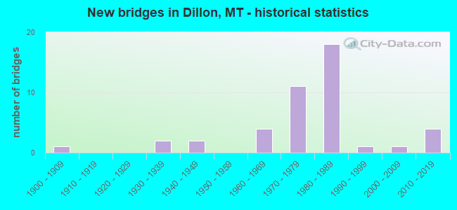
- New bridges - historical statistics
- 11900-1909
- 21930-1939
- 21940-1949
- 41960-1969
- 111970-1979
- 181980-1989
- 11990-1999
- 12000-2009
- 42010-2019


- Bridge Condition - Deck
- 41.2%Good
- 38.2%Satisfactory
- 20.6%Fair

- Bridge Condition - Superstructure
- 64.7%Good
- 23.5%Satisfactory
- 5.9%Fair
- 2.9%Poor
- 2.9%Serious

- Bridge Condition - Substructure
- 38.2%Good
- 44.1%Satisfactory
- 11.8%Fair
- 2.9%Poor
- 2.9%Serious

- Bridge Condition - Channel
- 65.2%Very good
- 17.4%Good
- 13.0%Satisfactory
- 4.3%Fair
Find on map >> Show street view
Structure Number: I00015059+07111, Location: 3.7M S DILLON (Lat: 45.179275, Lng: -112.693067), Route carried "on" structure: Interstate 15, Year Built: 1982, Status: Open, Structure Length: 3.90m (12.80ft), Average Daily Traffic: 3,894 (year 2020), Truck Traffic: 24%, Average Future Daily Traffic: 4,089 (year 2040), Design Load: HS 20, Features Intersected: INT JACKSON-HWY 278
Minimum Vertical Clearance: 30+ m (98+ ft), Kilometerpoint: 96.076, Lanes on structure: 2, Lanes under structure: 2, Base Highway Network: Yes, Owner: State Highway Agency, Approaching Roadway Width: 12.6m (41.3ft), Material/Design: Prestressed concrete, Design/Construction: Stringer/Multi-beam, Number Of Spans In Main Unit: 3, Length of Maximum Span: 19.8m (65.0ft), Curb-To-Curb Width: 12.6m (41.3ft), Out-to-Out Width: 13.4m (44.0ft)
Condition: Deck: Satisfactory, Superstructure: Good, Substructure: Good, Operating Rating: 47.2 metric tons, Method Used To Determine Operating Rating: Load and Resistance Factor (LRFR), Inventory Rating: 26.3 metric tons, Method Used To Determine Inventory Rating: Load and Resistance Factor (LRFR), Structural Evaluation: Equal to present minimum criteria, Deck Geometry: Better than present minimum criteria, Underclear: Equal to present minimum criteria, Approach Roadway Alignment: Equal to present desirable criteria, Designated Inspection Frequency: Every 24 months, Inspection Date: November 2021, Deck Structure Type: Concrete Cast-file-Place
Find on map >> Show street view
Structure Number: I00015059+07112, Location: 3.7M S DILLON (Lat: 45.179367, Lng: -112.693447), Route carried "on" structure: Interstate 15, Year Built: 1982, Status: Open, Structure Length: 3.90m (12.80ft), Average Daily Traffic: 4,752 (year 2020), Truck Traffic: 21%, Average Future Daily Traffic: 5,156 (year 2040), Design Load: HS 20, Features Intersected: INT JACKSON-HWY 278
Minimum Vertical Clearance: 30+ m (98+ ft), Kilometerpoint: 96.131, Lanes on structure: 2, Lanes under structure: 2, Base Highway Network: Yes, Owner: State Highway Agency, Approaching Roadway Width: 12.6m (41.3ft), Material/Design: Prestressed concrete, Design/Construction: Stringer/Multi-beam, Number Of Spans In Main Unit: 3, Length of Maximum Span: 19.8m (65.0ft), Curb-To-Curb Width: 12.6m (41.3ft), Out-to-Out Width: 13.4m (44.0ft)
Condition: Deck: Good, Superstructure: Good, Substructure: Good, Operating Rating: 46.3 metric tons, Method Used To Determine Operating Rating: Load and Resistance Factor (LRFR), Inventory Rating: 26.3 metric tons, Method Used To Determine Inventory Rating: Load and Resistance Factor (LRFR), Structural Evaluation: Equal to present minimum criteria, Deck Geometry: Better than present minimum criteria, Underclear: Equal to present minimum criteria, Approach Roadway Alignment: Equal to present desirable criteria, Designated Inspection Frequency: Every 24 months, Inspection Date: November 2021, Deck Structure Type: Concrete Cast-file-Place
Find on map >> Show street view
Structure Number: I00015060+01522, Location: 3.1M S DILLON (Lat: 45.184944, Lng: -112.689247), Route carried "on" structure: Interstate 15, Year Built: 1982, Status: Open, Structure Length: 4.31m (14.14ft), Average Daily Traffic: 4,752 (year 2020), Truck Traffic: 21%, Average Future Daily Traffic: 5,156 (year 2040), Design Load: HS 20, Features Intersected: BEAVERHEAD RIVER
Minimum Vertical Clearance: 30+ m (98+ ft), Kilometerpoint: 96.837, Lanes on structure: 2, Base Highway Network: Yes, Owner: State Highway Agency, Approaching Roadway Width: 11.6m (38.1ft), Material/Design: Prestressed concrete, Design/Construction: Stringer/Multi-beam, Number Of Spans In Main Unit: 2, Length of Maximum Span: 30.5m (100.1ft), Curb-To-Curb Width: 12.6m (41.3ft), Out-to-Out Width: 13.7m (44.9ft)
Condition: Deck: Satisfactory, Superstructure: Good, Substructure: Satisfactory, Channel: Very good, Operating Rating: 53.5 metric tons, Method Used To Determine Operating Rating: Load and Resistance Factor (LRFR), Inventory Rating: 27.2 metric tons, Method Used To Determine Inventory Rating: Load and Resistance Factor (LRFR), Structural Evaluation: Equal to present minimum criteria, Deck Geometry: Better than present minimum criteria, Waterway Adequacy: Equal to present desirable criteria, Approach Roadway Alignment: Equal to present desirable criteria, Designated Inspection Frequency: Every 24 months, Inspection Date: May 2020, Deck Structure Type: Concrete Cast-file-Place
Find on map >> Show street view
Structure Number: I00015060+01771, Location: 3.1M S DILLON (Lat: 45.184931, Lng: -112.687947), Route carried "on" structure: Interstate 15, Year Built: 1982, Status: Open, Structure Length: 4.31m (14.14ft), Average Daily Traffic: 4,752 (year 2020), Truck Traffic: 21%, Average Future Daily Traffic: 5,156 (year 2040), Design Load: HS 20, Features Intersected: BEAVERHEAD RIVER
Minimum Vertical Clearance: 30+ m (98+ ft), Kilometerpoint: 96.828, Lanes on structure: 2, Base Highway Network: Yes, Owner: State Highway Agency, Approaching Roadway Width: 12.6m (41.3ft), Material/Design: Prestressed concrete, Design/Construction: Stringer/Multi-beam, Number Of Spans In Main Unit: 2, Length of Maximum Span: 30.7m (100.7ft), Curb-To-Curb Width: 12.6m (41.3ft), Out-to-Out Width: 13.5m (44.3ft)
Condition: Deck: Fair, Superstructure: Good, Substructure: Satisfactory, Channel: Good, Operating Rating: 56.2 metric tons, Method Used To Determine Operating Rating: Load and Resistance Factor (LRFR), Inventory Rating: 43.5 metric tons, Method Used To Determine Inventory Rating: Load and Resistance Factor (LRFR), Structural Evaluation: Equal to present minimum criteria, Deck Geometry: Better than present minimum criteria, Waterway Adequacy: Equal to present desirable criteria, Approach Roadway Alignment: Equal to present desirable criteria, Designated Inspection Frequency: Every 24 months, Inspection Date: Febuary 2022, Deck Structure Type: Concrete Cast-file-Place
Find on map >> Show street view
Structure Number: I00015060+08831, Location: 2.5M S DILLON (Lat: 45.188358, Lng: -112.679500), Route carried "on" structure: Interstate 15, Year Built: 1983, Status: Open, Structure Length: 2.23m (7.32ft), Average Daily Traffic: 4,752 (year 2020), Truck Traffic: 21%, Average Future Daily Traffic: 5,156 (year 2040), Design Load: HS 20, Features Intersected: POINDEXTER SLOUGH
Minimum Vertical Clearance: 30+ m (98+ ft), Kilometerpoint: 97.595, Lanes on structure: 2, Base Highway Network: Yes, Owner: State Highway Agency, Approaching Roadway Width: 12.6m (41.3ft), Skew: 3 degrees, Material/Design: Prestressed concrete, Design/Construction: Stringer/Multi-beam, Number Of Spans In Main Unit: 1, Length of Maximum Span: 21.3m (69.9ft), Curb-To-Curb Width: 12.6m (41.3ft), Out-to-Out Width: 13.5m (44.3ft)
Condition: Deck: Satisfactory, Superstructure: Good, Substructure: Satisfactory, Channel: Very good, Operating Rating: 50.8 metric tons, Method Used To Determine Operating Rating: Load and Resistance Factor (LRFR), Inventory Rating: 29.0 metric tons, Method Used To Determine Inventory Rating: Load and Resistance Factor (LRFR), Structural Evaluation: Equal to present minimum criteria, Deck Geometry: Better than present minimum criteria, Waterway Adequacy: Equal to present desirable criteria, Approach Roadway Alignment: Equal to present desirable criteria, Designated Inspection Frequency: Every 24 months, Inspection Date: January 2022, Deck Structure Type: Concrete Cast-file-Place
Find on map >> Show street view
Structure Number: I00015060+08832, Location: 2.5M S DILLON (Lat: 45.188608, Lng: -112.679633), Route carried "on" structure: Interstate 15, Year Built: 1983, Status: Open, Structure Length: 2.23m (7.32ft), Average Daily Traffic: 4,752 (year 2020), Truck Traffic: 21%, Average Future Daily Traffic: 5,156 (year 2040), Design Load: HS 20, Features Intersected: POINDEXTER SLOUGH
Minimum Vertical Clearance: 30+ m (98+ ft), Kilometerpoint: 97.693, Lanes on structure: 2, Base Highway Network: Yes, Owner: State Highway Agency, Approaching Roadway Width: 12.6m (41.3ft), Skew: 3 degrees, Material/Design: Prestressed concrete, Design/Construction: Stringer/Multi-beam, Number Of Spans In Main Unit: 1, Length of Maximum Span: 21.3m (69.9ft), Curb-To-Curb Width: 12.6m (41.3ft), Out-to-Out Width: 13.5m (44.3ft)
Condition: Deck: Fair, Superstructure: Good, Substructure: Fair, Channel: Good, Operating Rating: 50.8 metric tons, Method Used To Determine Operating Rating: Load and Resistance Factor (LRFR), Inventory Rating: 29.0 metric tons, Method Used To Determine Inventory Rating: Load and Resistance Factor (LRFR), Structural Evaluation: Somewhat better than minimum adequacy, Deck Geometry: Better than present minimum criteria, Waterway Adequacy: Equal to present desirable criteria, Approach Roadway Alignment: Equal to present desirable criteria, Designated Inspection Frequency: Every 24 months, Inspection Date: Febuary 2022, Deck Structure Type: Concrete Cast-file-Place
Find on map >> Show street view
Structure Number: I00015060+09941, Location: 2.5M S DILLON (Lat: 45.189092, Lng: -112.677503), Route carried "on" structure: Interstate 15, Year Built: 1983, Status: Open, Structure Length: 1.83m (6.00ft), Average Daily Traffic: 4,752 (year 2020), Truck Traffic: 21%, Average Future Daily Traffic: 5,156 (year 2040), Design Load: HS 20, Features Intersected: SEP LOCAL ROAD
Minimum Vertical Clearance: 30+ m (98+ ft), Kilometerpoint: 97.771, Lanes on structure: 2, Base Highway Network: Yes, Owner: State Highway Agency, Approaching Roadway Width: 11.6m (38.1ft), Material/Design: Concrete continuous, Design/Construction: Slab, Number Of Spans In Main Unit: 3, Length of Maximum Span: 7.0m (23.0ft), Curb-To-Curb Width: 12.6m (41.3ft), Out-to-Out Width: 13.5m (44.3ft)
Condition: Deck: Satisfactory, Superstructure: Good, Substructure: Satisfactory, Operating Rating: 37.2 metric tons, Method Used To Determine Operating Rating: Load and Resistance Factor (LRFR), Inventory Rating: 28.1 metric tons, Method Used To Determine Inventory Rating: Load and Resistance Factor (LRFR), Structural Evaluation: Equal to present minimum criteria, Deck Geometry: Better than present minimum criteria, Approach Roadway Alignment: Equal to present desirable criteria, Designated Inspection Frequency: Every 24 months, Inspection Date: January 2021, Deck Structure Type: Concrete Cast-file-Place
Find on map >> Show street view
Structure Number: I00015060+09942, Location: 2.5M S DILLON (Lat: 45.189344, Lng: -112.677681), Route carried "on" structure: Interstate 15, Year Built: 1983, Status: Open, Structure Length: 1.92m (6.30ft), Average Daily Traffic: 4,752 (year 2020), Truck Traffic: 21%, Average Future Daily Traffic: 5,156 (year 2040), Design Load: HS 20, Features Intersected: SEP LOCAL ROAD
Minimum Vertical Clearance: 30+ m (98+ ft), Kilometerpoint: 97.871, Lanes on structure: 2, Base Highway Network: Yes, Owner: State Highway Agency, Approaching Roadway Width: 12.2m (40.0ft), Material/Design: Concrete continuous, Design/Construction: Slab, Number Of Spans In Main Unit: 3, Length of Maximum Span: 7.0m (23.0ft), Curb-To-Curb Width: 11.6m (38.1ft), Out-to-Out Width: 13.5m (44.3ft)
Condition: Deck: Satisfactory, Superstructure: Good, Substructure: Satisfactory, Operating Rating: 37.2 metric tons, Method Used To Determine Operating Rating: Load and Resistance Factor (LRFR), Inventory Rating: 28.1 metric tons, Method Used To Determine Inventory Rating: Load and Resistance Factor (LRFR), Structural Evaluation: Equal to present minimum criteria, Deck Geometry: Equal to present minimum criteria, Approach Roadway Alignment: Equal to present desirable criteria, Designated Inspection Frequency: Every 24 months, Inspection Date: January 2021, Deck Structure Type: Concrete Cast-file-Place
Find on map >> Show street view
Structure Number: I00015063+04941, Location: DILLON (Lat: 45.218431, Lng: -112.645783), Route carried "on" structure: Interstate 15, Year Built: 1983, Status: Open, Structure Length: 5.58m (18.31ft), Average Daily Traffic: 4,571 (year 2020), Truck Traffic: 22%, Average Future Daily Traffic: 4,960 (year 2040), Design Load: HS 20, Features Intersected: SEP PARK STREET
Minimum Vertical Clearance: 30+ m (98+ ft), Kilometerpoint: 101.954, Lanes on structure: 2, Lanes under structure: 2, Base Highway Network: Yes, Owner: State Highway Agency, Approaching Roadway Width: 11.6m (38.1ft), Skew: 3 degrees, Material/Design: Prestressed concrete, Design/Construction: Stringer/Multi-beam, Number Of Spans In Main Unit: 3, Length of Maximum Span: 22.9m (75.1ft), Curb-To-Curb Width: 12.6m (41.3ft), Out-to-Out Width: 13.5m (44.3ft)
Condition: Deck: Satisfactory, Superstructure: Good, Substructure: Satisfactory, Operating Rating: 48.1 metric tons, Method Used To Determine Operating Rating: Load and Resistance Factor (LRFR), Inventory Rating: 24.5 metric tons, Method Used To Determine Inventory Rating: Load and Resistance Factor (LRFR), Structural Evaluation: Equal to present minimum criteria, Deck Geometry: Better than present minimum criteria, Underclear: Better than present minimum criteria, Approach Roadway Alignment: Equal to present desirable criteria, Designated Inspection Frequency: Every 24 months, Inspection Date: November 2021, Deck Structure Type: Concrete Cast-file-Place, Wearing Surface/Protective System: Wearing Surface: Monolithic Concrete
Find on map >> Show street view
Structure Number: I00015063+04942, Location: DILLON (Lat: 45.218422, Lng: -112.646256), Route carried "on" structure: Interstate 15, Year Built: 1983, Status: Open, Structure Length: 5.58m (18.31ft), Average Daily Traffic: 4,571 (year 2020), Truck Traffic: 22%, Average Future Daily Traffic: 4,960 (year 2040), Design Load: HS 20, Features Intersected: SEP PARK STREET
Minimum Vertical Clearance: 30+ m (98+ ft), Kilometerpoint: 102.014, Lanes on structure: 2, Lanes under structure: 2, Base Highway Network: Yes, Owner: State Highway Agency, Approaching Roadway Width: 11.6m (38.1ft), Skew: 3 degrees, Material/Design: Prestressed concrete, Design/Construction: Stringer/Multi-beam, Number Of Spans In Main Unit: 3, Length of Maximum Span: 22.7m (74.5ft), Curb-To-Curb Width: 12.6m (41.3ft), Out-to-Out Width: 13.6m (44.6ft)
Condition: Deck: Good, Superstructure: Good, Substructure: Satisfactory, Operating Rating: 48.1 metric tons, Method Used To Determine Operating Rating: Load and Resistance Factor (LRFR), Inventory Rating: 24.5 metric tons, Method Used To Determine Inventory Rating: Load and Resistance Factor (LRFR), Structural Evaluation: Equal to present minimum criteria, Deck Geometry: Better than present minimum criteria, Underclear: Better than present minimum criteria, Approach Roadway Alignment: Equal to present desirable criteria, Designated Inspection Frequency: Every 24 months, Inspection Date: November 2021, Deck Structure Type: Concrete Cast-file-Place, Wearing Surface/Protective System: Wearing Surface: Monolithic Concrete
Find on map >> Show street view
Structure Number: I00015064+00881, Location: 0.6M N DILLON (Lat: 45.229639, Lng: -112.640919), Route carried "on" structure: Interstate 15, Year Built: 1973, Status: Open, Structure Length: 4.36m (14.30ft), Average Daily Traffic: 3,356 (year 2020), Truck Traffic: 23%, Average Future Daily Traffic: 3,641 (year 2040), Design Load: HS 20, Features Intersected: BEAVERHEAD RIVER
Minimum Vertical Clearance: 30+ m (98+ ft), Kilometerpoint: 103.264, Lanes on structure: 2, Base Highway Network: Yes, Owner: State Highway Agency, Approaching Roadway Width: 12.5m (41.0ft), Material/Design: Prestressed concrete, Design/Construction: Stringer/Multi-beam, Number Of Spans In Main Unit: 2, Length of Maximum Span: 21.3m (69.9ft), Curb-To-Curb Width: 12.6m (41.3ft), Out-to-Out Width: 13.4m (44.0ft)
Condition: Deck: Good, Superstructure: Good, Substructure: Good, Channel: Fair, Operating Rating: 40.8 metric tons, Method Used To Determine Operating Rating: Load and Resistance Factor (LRFR), Inventory Rating: 17.2 metric tons, Method Used To Determine Inventory Rating: Load and Resistance Factor (LRFR), Structural Evaluation: Meets minimum limits, Deck Geometry: Better than present minimum criteria, Waterway Adequacy: Equal to present minimum criteria, Approach Roadway Alignment: Equal to present desirable criteria, Designated Inspection Frequency: Every 24 months, Inspection Date: November 2021, Deck Structure Type: Concrete Cast-file-Place
Find on map >> Show street view
Structure Number: I00015064+00882, Location: 0.6M N DILLON (Lat: 45.229686, Lng: -112.641319), Route carried "on" structure: Interstate 15, Year Built: 1973, Status: Open, Structure Length: 4.36m (14.30ft), Average Daily Traffic: 3,356 (year 2020), Truck Traffic: 23%, Average Future Daily Traffic: 3,641 (year 2040), Design Load: HS 20, Features Intersected: BEAVERHEAD RIVER
Minimum Vertical Clearance: 30+ m (98+ ft), Kilometerpoint: 103.331, Lanes on structure: 2, Base Highway Network: Yes, Owner: State Highway Agency, Approaching Roadway Width: 12.5m (41.0ft), Material/Design: Prestressed concrete, Design/Construction: Stringer/Multi-beam, Number Of Spans In Main Unit: 2, Length of Maximum Span: 21.3m (69.9ft), Curb-To-Curb Width: 12.6m (41.3ft), Out-to-Out Width: 13.4m (44.0ft)
Condition: Deck: Good, Superstructure: Good, Substructure: Good, Channel: Satisfactory, Operating Rating: 40.8 metric tons, Method Used To Determine Operating Rating: Load and Resistance Factor (LRFR), Inventory Rating: 17.2 metric tons, Method Used To Determine Inventory Rating: Load and Resistance Factor (LRFR), Structural Evaluation: Meets minimum limits, Deck Geometry: Better than present minimum criteria, Waterway Adequacy: Better than present minimum criteria, Approach Roadway Alignment: Equal to present desirable criteria, Designated Inspection Frequency: Every 24 months, Inspection Date: November 2021, Deck Structure Type: Concrete Cast-file-Place
Find on map >> Show street view
Structure Number: I00015064+04001, Location: DILLON (Lat: 45.235314, Lng: -112.639531), Route carried "on" structure: Interstate 15, Year Built: 1973, Status: Open, Structure Length: 0.70m (2.30ft), Average Daily Traffic: 3,356 (year 2020), Truck Traffic: 23%, Average Future Daily Traffic: 3,641 (year 2040), Design Load: HS 20, Features Intersected: DRAINAGE IRR DITCH
Minimum Vertical Clearance: 30+ m (98+ ft), Kilometerpoint: 103.906, Lanes on structure: 4, Base Highway Network: Yes, Owner: State Highway Agency, Approaching Roadway Width: 24.2m (79.4ft), Skew: 4 degrees, Material/Design: Concrete, Design/Construction: Culvert, Number Of Spans In Main Unit: 1, Length of Maximum Span: 7.0m (23.0ft)
Condition: Channel: Very good, Culverts: Good, Operating Rating: 32.7 metric tons, Method Used To Determine Operating Rating: Allowable Stress (AS), Inventory Rating: 32.7 metric tons, Method Used To Determine Inventory Rating: Allowable Stress (AS), Structural Evaluation: Better than present minimum criteria, Waterway Adequacy: Better than present minimum criteria, Approach Roadway Alignment: Better than present minimum criteria, Designated Inspection Frequency: Every 24 months, Inspection Date: March 2020
Find on map >> Show street view
Structure Number: L01017008+08001, Location: 1M W DILLON (Lat: 45.216925, Lng: -112.660353), Route carried "on" structure: County highway 1017, Year Built: 1992, Status: Open, Structure Length: 3.14m (10.30ft), Average Daily Traffic: 100 (year 2022), Truck Traffic: 3%, Average Future Daily Traffic: 100 (year 2037), Design Load: HS 20, Features Intersected: BEAVERHEAD RIVER 005, Facility Carried by Structure: W PARK ST
Minimum Vertical Clearance: 30+ m (98+ ft), Kilometerpoint: 13.252, Lanes on structure: 2, Owner: County Highway Agency, Approaching Roadway Width: 7.3m (24.0ft), Skew: 1 degrees, Material/Design: Prestressed concrete, Design/Construction: Stringer/Multi-beam, Number Of Spans In Main Unit: 2, Length of Maximum Span: 15.4m (50.5ft), Curb-To-Curb Width: 8.5m (27.9ft), Out-to-Out Width: 9.2m (30.2ft)
Condition: Deck: Good, Superstructure: Good, Substructure: Good, Channel: Very good, Operating Rating: 67.9 metric tons, Method Used To Determine Operating Rating: Load Factor (LF), Inventory Rating: 36.3 metric tons, Method Used To Determine Inventory Rating: Load Factor (LF), Structural Evaluation: Better than present minimum criteria, Deck Geometry: Better than present minimum criteria, Waterway Adequacy: Equal to present desirable criteria, Approach Roadway Alignment: Better than present minimum criteria, Designated Inspection Frequency: Every 24 months, Inspection Date: August 2020, Deck Structure Type: Concrete Cast-file-Place, Wearing Surface/Protective System: Deck Protection: Epoxy Coated Reinforcing
Find on map >> Show street view
Structure Number: L01112000+02501, Location: 3M N DILLON (Lat: 45.261839, Lng: -112.648544), Route carried "on" structure: County highway 1112, Year Built: 2011, Status: Open, Structure Length: 0.90m (2.95ft), Average Daily Traffic: 328 (year 2020), Truck Traffic: 3%, Average Future Daily Traffic: 344 (year 2040), Design Load: HS 20, Features Intersected: WEST SIDE CANAL 126, Facility Carried by Structure: FRYING PAN ROAD
Minimum Vertical Clearance: 30+ m (98+ ft), Kilometerpoint: 0.528, Lanes on structure: 2, Owner: County Highway Agency, Approaching Roadway Width: 7.3m (24.0ft), Material/Design: Concrete, Design/Construction: Slab, Number Of Spans In Main Unit: 1, Length of Maximum Span: 8.5m (27.9ft), Curb-To-Curb Width: 8.5m (27.9ft), Out-to-Out Width: 9.1m (29.9ft)
Condition: Deck: Good, Superstructure: Good, Substructure: Good, Channel: Very good, Operating Rating: 55.3 metric tons, Method Used To Determine Operating Rating: Load Factor (LF), Inventory Rating: 33.6 metric tons, Method Used To Determine Inventory Rating: Load Factor (LF), Structural Evaluation: Better than present minimum criteria, Deck Geometry: Equal to present minimum criteria, Waterway Adequacy: Equal to present desirable criteria, Approach Roadway Alignment: Equal to present desirable criteria, Designated Inspection Frequency: Every 24 months, Inspection Date: November 2021, Deck Structure Type: Concrete Precast Panels
Find on map >> Show street view
Structure Number: L01112000+05201, Location: 3M N DILLON (Lat: 45.261792, Lng: -112.651764), Route carried "on" structure: ServiceCounty highway 1112, Year Built: 1973, Status: Open, Structure Length: 9.48m (31.10ft), Average Daily Traffic: 328 (year 2020), Truck Traffic: 3%, Average Future Daily Traffic: 344 (year 2040), Design Load: HS 20, Features Intersected: SEP I 15 126, Facility Carried by Structure: FRYING PAN RD
Minimum Vertical Clearance: 30+ m (98+ ft), Kilometerpoint: 0.781, Lanes on structure: 2, Lanes under structure: 4, Owner: State Highway Agency, Approaching Roadway Width: 9.1m (29.9ft), Skew: 2 degrees, Material/Design: Prestressed concrete, Design/Construction: Stringer/Multi-beam, Number Of Spans In Main Unit: 4, Length of Maximum Span: 30.5m (100.1ft), Curb or Sidewalk Widths: Left: 0.1m (0.3ft), Right: 0.1m (0.3ft), Curb-To-Curb Width: 9.0m (29.5ft), Out-to-Out Width: 9.7m (31.8ft)
Condition: Deck: Satisfactory, Superstructure: Satisfactory, Substructure: Fair, Inventory Rating: 45.5 metric tons, Method Used To Determine Inventory Rating: Load Factor (LF), Structural Evaluation: Somewhat better than minimum adequacy, Deck Geometry: Equal to present minimum criteria, Underclear: Better than present minimum criteria, Approach Roadway Alignment: Equal to present minimum criteria, Designated Inspection Frequency: Every 24 months, Inspection Date: April 2021, Deck Structure Type: Concrete Cast-file-Place, Wearing Surface/Protective System: Deck Protection: Bituminous
Find on map >> Show street view
Structure Number: L01202001+08001, Location: 2M S DILLON (Lat: 45.184539, Lng: -112.626536), Route carried "on" structure: County highway 1202, Year Built: 1962, Status: Posted for load, Structure Length: 2.19m (7.19ft), Average Daily Traffic: 100 (year 2022), Truck Traffic: 3%, Average Future Daily Traffic: 100 (year 2037), Design Load: H 20, Features Intersected: EAST BENCH CANAL 006, Facility Carried by Structure: BLACKTAIL RD
Minimum Vertical Clearance: 30+ m (98+ ft), Kilometerpoint: 3.103, Lanes on structure: 2, Owner: County Highway Agency, Approaching Roadway Width: 7.6m (24.9ft), Skew: 3 degrees, Material/Design: Wood or Timber, Design/Construction: Stringer/Multi-beam, Number Of Spans In Main Unit: 2, Length of Maximum Span: 11.0m (36.1ft), Curb-To-Curb Width: 9.0m (29.5ft), Out-to-Out Width: 9.2m (30.2ft)
Condition: Deck: Fair, Superstructure: Fair, Substructure: Satisfactory, Channel: Very good, Operating Rating: 13.6 metric tons, Method Used To Determine Operating Rating: Allowable Stress (AS), Inventory Rating: 7.3 metric tons, Method Used To Determine Inventory Rating: Allowable Stress (AS), Structural Evaluation: High priority of replacement, Deck Geometry: Better than present minimum criteria, Waterway Adequacy: Equal to present desirable criteria, Approach Roadway Alignment: Equal to present desirable criteria, Bridge Posting: Required (Relationship of Operating Rating to Maximum Legal Load: > 39.9% below), Length Of Structure Improvement: 3.00m (9.84ft), Designated Inspection Frequency: Every 24 months, Other Special Inspection Frequency: Every 6 months, Inspection Date: January 2022, Other Special Inspection Date: January 2022, Bridge Improvement Cost: $238,000, Roadway Improvement Cost: $119,000, Total Project Cost: $357,000, Deck Structure Type: Wood or Timber, Wearing Surface/Protective System: Wearing Surface: Bituminous
Find on map >> Show street view
Structure Number: L01206003+02001, Location: 3M E DILLON (Lat: 45.216528, Lng: -112.558000), Route carried "on" structure: County highway 1206, Year Built: 1962, Status: Posted for load, Structure Length: 1.83m (6.00ft), Average Daily Traffic: 100 (year 2022), Truck Traffic: 3%, Average Future Daily Traffic: 100 (year 2037), Design Load: H 20, Features Intersected: EAST BENCH CANAL 060, Facility Carried by Structure: SWEETWATER RD
Minimum Vertical Clearance: 30+ m (98+ ft), Kilometerpoint: 49.120, Lanes on structure: 2, Owner: County Highway Agency, Approaching Roadway Width: 7.3m (24.0ft), Material/Design: Wood or Timber, Design/Construction: Stringer/Multi-beam, Number Of Spans In Main Unit: 2, Length of Maximum Span: 8.7m (28.5ft), Curb-To-Curb Width: 8.9m (29.2ft), Out-to-Out Width: 9.1m (29.9ft)
Condition: Deck: Good, Superstructure: Satisfactory, Substructure: Good, Channel: Very good, Operating Rating: 36.3 metric tons, Method Used To Determine Operating Rating: Allowable Stress (AS), Inventory Rating: 24.5 metric tons, Method Used To Determine Inventory Rating: Allowable Stress (AS), Structural Evaluation: Equal to present minimum criteria, Deck Geometry: Better than present minimum criteria, Waterway Adequacy: Equal to present desirable criteria, Approach Roadway Alignment: Equal to present minimum criteria, Bridge Posting: Required (Relationship of Operating Rating to Maximum Legal Load: 0.1 - 9.9% below), Designated Inspection Frequency: Every 24 months, Inspection Date: December 2021, Deck Structure Type: Wood or Timber, Wearing Surface/Protective System: Wearing Surface: Gravel
Find on map >> Show street view
Structure Number: L01224000+09001, Location: 3M NE DILLON (Lat: 45.232789, Lng: -112.587128), Route carried "on" structure: County highway 1224, Year Built: 2010, Status: Open, Structure Length: 0.67m (2.20ft), Average Daily Traffic: 100 (year 2022), Truck Traffic: 3%, Average Future Daily Traffic: 100 (year 2037), Design Load: HS 20, Features Intersected: DILLON CANAL 129, Facility Carried by Structure: NISSEN LANE
Minimum Vertical Clearance: 30+ m (98+ ft), Kilometerpoint: 1.442, Lanes on structure: 2, Owner: County Highway Agency, Approaching Roadway Width: 7.3m (24.0ft), Skew: 2 degrees, Material/Design: Concrete, Design/Construction: Slab, Number Of Spans In Main Unit: 1, Length of Maximum Span: 6.2m (20.3ft), Curb-To-Curb Width: 10.0m (32.8ft), Out-to-Out Width: 10.7m (35.1ft)
Condition: Deck: Good, Superstructure: Good, Substructure: Good, Channel: Very good, Operating Rating: 58.1 metric tons, Method Used To Determine Operating Rating: Load Factor (LF), Inventory Rating: 34.5 metric tons, Method Used To Determine Inventory Rating: Load Factor (LF), Structural Evaluation: Better than present minimum criteria, Deck Geometry: Superior to present desirable criteria, Waterway Adequacy: Equal to present desirable criteria, Approach Roadway Alignment: Equal to present desirable criteria, Designated Inspection Frequency: Every 24 months, Inspection Date: November 2021, Deck Structure Type: Concrete Precast Panels
Find on map >> Show street view
Structure Number: L01224002+01001, Location: 3M E DILLON (Lat: 45.232667, Lng: -112.562475), Route carried "on" structure: County highway 1224, Year Built: 1962, Status: Posted for load, Structure Length: 1.58m (5.18ft), Average Daily Traffic: 100 (year 2022), Truck Traffic: 3%, Average Future Daily Traffic: 100 (year 2037), Design Load: H 15, Features Intersected: EAST BENCH CANAL 001, Facility Carried by Structure: NISSEN LN
Minimum Vertical Clearance: 30+ m (98+ ft), Kilometerpoint: 3.379, Lanes on structure: 2, Owner: County Highway Agency, Approaching Roadway Width: 5.5m (18.0ft), Material/Design: Wood or Timber, Design/Construction: Stringer/Multi-beam, Number Of Spans In Main Unit: 2, Length of Maximum Span: 7.9m (25.9ft), Curb-To-Curb Width: 7.7m (25.3ft), Out-to-Out Width: 7.9m (25.9ft)
Condition: Deck: Good, Superstructure: Fair, Substructure: Good, Channel: Very good, Operating Rating: 31.8 metric tons, Method Used To Determine Operating Rating: Allowable Stress (AS), Inventory Rating: 21.8 metric tons, Method Used To Determine Inventory Rating: Allowable Stress (AS), Structural Evaluation: Somewhat better than minimum adequacy, Deck Geometry: Equal to present minimum criteria, Waterway Adequacy: Equal to present desirable criteria, Approach Roadway Alignment: Better than present minimum criteria, Bridge Posting: Required (Relationship of Operating Rating to Maximum Legal Load: 20.0 - 29.9% below), Designated Inspection Frequency: Every 24 months, Inspection Date: January 2021, Deck Structure Type: Wood or Timber, Wearing Surface/Protective System: Wearing Surface: Gravel
Find on map >> Show street view
Structure Number: L01238001+00001, Location: 2M SE DILLON (Lat: 45.199353, Lng: -112.616142), Route carried "on" structure: County highway 1238, Year Built: 1962, Status: Open, Structure Length: 1.65m (5.41ft), Average Daily Traffic: 100 (year 2022), Truck Traffic: 3%, Average Future Daily Traffic: 100 (year 2037), Features Intersected: EAST BENCH CANAL 102, Facility Carried by Structure: WHITE LN
Minimum Vertical Clearance: 30+ m (98+ ft), Kilometerpoint: 1.385, Lanes on structure: 2, Owner: County Highway Agency, Approaching Roadway Width: 5.8m (19.0ft), Material/Design: Wood or Timber, Design/Construction: Stringer/Multi-beam, Number Of Spans In Main Unit: 2, Length of Maximum Span: 8.2m (26.9ft), Curb or Sidewalk Widths: Left: 0.1m (0.3ft), Right: 0.1m (0.3ft), Curb-To-Curb Width: 7.7m (25.3ft), Out-to-Out Width: 7.9m (25.9ft)
Condition: Deck: Good, Superstructure: Satisfactory, Substructure: Good, Channel: Good, Operating Rating: 31.7 metric tons, Method Used To Determine Operating Rating: Allowable Stress (AS), Inventory Rating: 21.7 metric tons, Method Used To Determine Inventory Rating: Allowable Stress (AS), Structural Evaluation: Equal to present minimum criteria, Deck Geometry: Equal to present minimum criteria, Waterway Adequacy: Equal to present desirable criteria, Approach Roadway Alignment: Equal to present minimum criteria, Designated Inspection Frequency: Every 24 months, Inspection Date: December 2021, Deck Structure Type: Wood or Timber, Wearing Surface/Protective System: Wearing Surface: Wood or Timber
Find on map >> Show street view
Structure Number: L01279000+04001, Location: 1M N DILLON (Lat: 45.235842, Lng: -112.625317), Route carried "on" structure: County highway 1279, Year Built: 2001, Status: Open, Structure Length: 4.35m (14.27ft), Average Daily Traffic: 2,639 (year 2020), Truck Traffic: 1%, Average Future Daily Traffic: 2,771 (year 2040), Design Load: HS 20, Features Intersected: BEAVERHEAD RIVER 095, Facility Carried by Structure: LAKNAR LN
Minimum Vertical Clearance: 30+ m (98+ ft), Kilometerpoint: 0.473, Lanes on structure: 2, Owner: County Highway Agency, Approaching Roadway Width: 13.0m (42.7ft), Skew: 1 degrees, Material/Design: Prestressed concrete continuous, Design/Construction: Stringer/Multi-beam, Number Of Spans In Main Unit: 2, Length of Maximum Span: 21.8m (71.5ft), Curb-To-Curb Width: 12.2m (40.0ft), Out-to-Out Width: 13.0m (42.7ft)
Condition: Deck: Satisfactory, Superstructure: Good, Substructure: Satisfactory, Channel: Very good, Operating Rating: 71.5 metric tons, Method Used To Determine Operating Rating: Load Factor (LF), Inventory Rating: 38.3 metric tons, Method Used To Determine Inventory Rating: Load Factor (LF), Structural Evaluation: Equal to present minimum criteria, Deck Geometry: Equal to present minimum criteria, Waterway Adequacy: Equal to present desirable criteria, Approach Roadway Alignment: Equal to present minimum criteria, Designated Inspection Frequency: Every 24 months, Inspection Date: August 2021, Deck Structure Type: Concrete Cast-file-Place, Wearing Surface/Protective System: Deck Protection: Epoxy Coated Reinforcing
Find on map >> Show street view
Structure Number: L01311000+06001, Location: 1M N DILLON (Lat: 45.233303, Lng: -112.631839), Route carried "on" structure: ServiceState highway 81001, Year Built: 1946, Status: Open, Structure Length: 4.56m (14.96ft), Average Daily Traffic: 2,359 (year 2020), Average Future Daily Traffic: 2,477 (year 2040), Design Load: HS 20, Features Intersected: BEAVERHEAD RIVER 033, Facility Carried by Structure: HWY 91 N
Minimum Vertical Clearance: 30+ m (98+ ft), Kilometerpoint: 0.962, Lanes on structure: 2, Owner: State Highway Agency, Approaching Roadway Width: 8.5m (27.9ft), Material/Design: Steel continuous, Design/Construction: Stringer/Multi-beam, Number Of Spans In Main Unit: 3, Length of Maximum Span: 17.5m (57.4ft), Curb or Sidewalk Widths: Left: 1.3m (4.3ft), Right: 1.3m (4.3ft), Curb-To-Curb Width: 8.5m (27.9ft), Out-to-Out Width: 9.7m (31.8ft)
Condition: Deck: Fair, Superstructure: Satisfactory, Substructure: Satisfactory, Channel: Satisfactory, Operating Rating: 66.0 metric tons, Method Used To Determine Operating Rating: Load Factor (LF), Inventory Rating: 39.5 metric tons, Method Used To Determine Inventory Rating: Load Factor (LF), Structural Evaluation: Equal to present minimum criteria, Deck Geometry: Meets minimum limits, Waterway Adequacy: Equal to present desirable criteria, Approach Roadway Alignment: Equal to present desirable criteria, Designated Inspection Frequency: Every 24 months, Inspection Date: May 2021, Deck Structure Type: Concrete Cast-file-Place, Wearing Surface/Protective System: Wearing Surface: Bituminous
Find on map >> Show street view
Structure Number: L01315000+07001, Location: 1M N DILLON (Lat: 45.235136, Lng: -112.639556), Route carried "on" structure: ServiceCounty highway 1315, Year Built: 1973, Status: Open, Structure Length: 9.08m (29.79ft), Average Daily Traffic: 412 (year 2020), Truck Traffic: 3%, Average Future Daily Traffic: 433 (year 2040), Design Load: HS 20, Features Intersected: SEP I 15 12, Facility Carried by Structure: LOVERS LEAP RD
Minimum Vertical Clearance: 30+ m (98+ ft), Kilometerpoint: 0.662, Lanes on structure: 2, Lanes under structure: 4, Owner: State Highway Agency, Approaching Roadway Width: 9.8m (32.2ft), Skew: 1 degrees, Material/Design: Prestressed concrete, Design/Construction: Stringer/Multi-beam, Number Of Spans In Main Unit: 4, Length of Maximum Span: 29.6m (97.1ft), Curb or Sidewalk Widths: Left: 0.2m (0.7ft), Right: 0.2m (0.7ft), Curb-To-Curb Width: 9.6m (31.5ft), Out-to-Out Width: 10.3m (33.8ft)
Condition: Deck: Good, Superstructure: Good, Substructure: Satisfactory, Operating Rating: 83.6 metric tons, Method Used To Determine Operating Rating: Load Factor (LF), Inventory Rating: 35.8 metric tons, Method Used To Determine Inventory Rating: Load Factor (LF), Structural Evaluation: Equal to present minimum criteria, Deck Geometry: Equal to present minimum criteria, Underclear: Equal to present minimum criteria, Approach Roadway Alignment: Equal to present minimum criteria, Designated Inspection Frequency: Every 48 months, Inspection Date: Febuary 2021, Deck Structure Type: Concrete Cast-file-Place
Find on map >> Show street view
Structure Number: L01559000+02001, Location: 1.2M S BARRETTS INT (Lat: 45.116017, Lng: -112.750944), Route carried "on" structure: ServiceCounty highway 559, Year Built: 1908, Status: Posted for load, Structure Length: 2.93m (9.61ft), Average Daily Traffic: 24 (year 2020), Truck Traffic: 3%, Average Future Daily Traffic: 25 (year 2040), Features Intersected: BEAVERHEAD RIVER 023, Facility Carried by Structure: RYAN CANYON RD
Minimum Vertical Clearance: 4.72m (15.49ft), Kilometerpoint: 0.090, Lanes on structure: 1, Owner: County Highway Agency, Approaching Roadway Width: 4.6m (15.1ft), Material/Design: Steel, Design/Construction: Truss - Thru, Number Of Spans In Main Unit: 1, Length of Maximum Span: 29.3m (96.1ft), Curb-To-Curb Width: 4.3m (14.1ft), Out-to-Out Width: 4.9m (16.1ft)
Condition: Deck: Good, Superstructure: Serious, Substructure: Fair, Channel: Very good, Operating Rating: 11.8 metric tons, Method Used To Determine Operating Rating: Load Factor (LF), Inventory Rating: 7.3 metric tons, Method Used To Determine Inventory Rating: Load Factor (LF), Structural Evaluation: High priority of replacement, Deck Geometry: Equal to present minimum criteria, Waterway Adequacy: Equal to present desirable criteria, Approach Roadway Alignment: Meets minimum limits, Bridge Posting: Required (Relationship of Operating Rating to Maximum Legal Load: > 39.9% below), Length Of Structure Improvement: 3.80m (12.47ft), Designated Inspection Frequency: Every 24 months, Critical Feature Inspection Frequency: Every 24 months, Inspection Date: July 2020, Critical Feature Inspection Date: July 2020, Bridge Improvement Cost: $141,000, Roadway Improvement Cost: $71,000, Total Project Cost: $212,000, Deck Structure Type: Corrugated Steel, Wearing Surface/Protective System: Wearing Surface: Wood or Timber
Find on map >> Show street view
Structure Number: M01033000+00101, Location: DILLON-S RAILROAD AVE (Lat: 45.217061, Lng: -112.639583), Route carried "on" structure: City street 1033, Year Built: 2010, Status: Open, Structure Length: 1.40m (4.59ft), Average Daily Traffic: 100 (year 2022), Truck Traffic: 3%, Average Future Daily Traffic: 100 (year 2037), Design Load: HS 20, Features Intersected: BLACKTAIL DEER CREEK 130, Facility Carried by Structure: S RAILROAD AVENUE
Minimum Vertical Clearance: 30+ m (98+ ft), Kilometerpoint: 0.894, Lanes on structure: 2, Owner: County Highway Agency, Approaching Roadway Width: 13.2m (43.3ft), Skew: 1 degrees, Material/Design: Prestressed concrete, Design/Construction: Tee Beam, Number Of Spans In Main Unit: 1, Length of Maximum Span: 13.7m (44.9ft), Curb or Sidewalk Widths: Left: 0.0m, Right: 2.2m (7.2ft), Curb-To-Curb Width: 10.7m (35.1ft), Out-to-Out Width: 11.3m (37.1ft)
Condition: Deck: Good, Superstructure: Satisfactory, Substructure: Good, Channel: Very good, Operating Rating: 56.2 metric tons, Method Used To Determine Operating Rating: Load Factor (LF), Inventory Rating: 31.3 metric tons, Method Used To Determine Inventory Rating: Load Factor (LF), Structural Evaluation: Equal to present minimum criteria, Deck Geometry: Superior to present desirable criteria, Waterway Adequacy: Equal to present desirable criteria, Approach Roadway Alignment: Equal to present desirable criteria, Designated Inspection Frequency: Every 24 months, Inspection Date: November 2021, Deck Structure Type: Concrete Precast Panels, Wearing Surface/Protective System: Wearing Surface: Bituminous
Find on map >> Show street view
Structure Number: M01033000+00201, Location: DILLON-E REEDER ST (Lat: 45.216014, Lng: -112.640556), Route carried "on" structure: City street 1033, Year Built: 2010, Status: Open, Structure Length: 1.40m (4.59ft), Average Daily Traffic: 1,658 (year 2020), Truck Traffic: 3%, Average Future Daily Traffic: 1,741 (year 2040), Design Load: HS 20, Features Intersected: BLACKTAIL DEER CREEK 131, Facility Carried by Structure: E REEDER STREET
Minimum Vertical Clearance: 30+ m (98+ ft), Kilometerpoint: 0.434, Lanes on structure: 2, Owner: County Highway Agency, Approaching Roadway Width: 10.7m (35.1ft), Material/Design: Prestressed concrete, Design/Construction: Tee Beam, Number Of Spans In Main Unit: 1, Length of Maximum Span: 13.7m (44.9ft), Curb or Sidewalk Widths: Left: 0.0m, Right: 2.2m (7.2ft), Curb-To-Curb Width: 11.6m (38.1ft), Out-to-Out Width: 12.2m (40.0ft)
Condition: Deck: Good, Superstructure: Good, Substructure: Good, Channel: Very good, Operating Rating: 56.3 metric tons, Method Used To Determine Operating Rating: Load Factor (LF), Inventory Rating: 30.9 metric tons, Method Used To Determine Inventory Rating: Load Factor (LF), Structural Evaluation: Better than present minimum criteria, Deck Geometry: Equal to present minimum criteria, Waterway Adequacy: Equal to present desirable criteria, Approach Roadway Alignment: Equal to present desirable criteria, Designated Inspection Frequency: Every 24 months, Inspection Date: November 2021, Deck Structure Type: Other, Wearing Surface/Protective System: Wearing Surface: Bituminous
Find on map >> Show street view
Structure Number: P00089000+00001, Location: DILLON (Lat: 45.206881, Lng: -112.654625), Route carried "on" structure: State highway 89, Year Built: 1983, Status: Open, Structure Length: 8.78m (28.81ft), Average Daily Traffic: 1,539 (year 2020), Truck Traffic: 2%, Average Future Daily Traffic: 1,616 (year 2040), Design Load: HS 20, Features Intersected: INT SOUTH DILLON I 15
Minimum Vertical Clearance: 30+ m (98+ ft), Kilometerpoint: 0.000, Lanes on structure: 2, Lanes under structure: 4, Base Highway Network: Yes, Owner: State Highway Agency, Approaching Roadway Width: 14.4m (47.2ft), Material/Design: Prestressed concrete, Design/Construction: Stringer/Multi-beam, Number Of Spans In Main Unit: 4, Length of Maximum Span: 29.6m (97.1ft), Curb-To-Curb Width: 14.4m (47.2ft), Out-to-Out Width: 15.3m (50.2ft)
Condition: Deck: Fair, Superstructure: Good, Substructure: Satisfactory, Operating Rating: 61.8 metric tons, Method Used To Determine Operating Rating: Load Factor (LF), Inventory Rating: 41.4 metric tons, Method Used To Determine Inventory Rating: Load Factor (LF), Structural Evaluation: Equal to present minimum criteria, Deck Geometry: Superior to present desirable criteria, Underclear: Equal to present minimum criteria, Approach Roadway Alignment: Equal to present desirable criteria, Designated Inspection Frequency: Every 48 months, Inspection Date: Febuary 2022, Deck Structure Type: Concrete Cast-file-Place, Wearing Surface/Protective System: Wearing Surface: Monolithic Concrete
Find on map >> Show street view
Structure Number: P00089000+01261, Location: SOUTH DILLON (Lat: 45.206033, Lng: -112.652328), Route carried "on" structure: State highway 89, Year Built: 1983, Status: Open, Structure Length: 6.58m (21.59ft), Average Daily Traffic: 1,539 (year 2020), Truck Traffic: 2%, Average Future Daily Traffic: 1,616 (year 2040), Design Load: HS 20, Features Intersected: RR
Minimum Vertical Clearance: 30+ m (98+ ft), Kilometerpoint: 0.191, Lanes on structure: 2, Base Highway Network: Yes, Owner: State Highway Agency, Approaching Roadway Width: 14.3m (46.9ft), Skew: 1 degrees, Material/Design: Prestressed concrete, Design/Construction: Stringer/Multi-beam, Number Of Spans In Main Unit: 3, Length of Maximum Span: 23.3m (76.4ft), Curb-To-Curb Width: 14.4m (47.2ft), Out-to-Out Width: 15.4m (50.5ft)
Condition: Deck: Fair, Superstructure: Good, Substructure: Satisfactory, Operating Rating: 49.0 metric tons, Method Used To Determine Operating Rating: Load and Resistance Factor (LRFR), Inventory Rating: 37.2 metric tons, Method Used To Determine Inventory Rating: Load and Resistance Factor (LRFR), Structural Evaluation: Equal to present minimum criteria, Deck Geometry: Superior to present desirable criteria, Underclear: Superior to present desirable criteria, Approach Roadway Alignment: Equal to present desirable criteria, Designated Inspection Frequency: Every 24 months, Inspection Date: January 2022, Deck Structure Type: Concrete Cast-file-Place
Find on map >> Show street view
Structure Number: P00089000+03311, Location: SOUTH DILLON (Lat: 45.204900, Lng: -112.648467), Route carried "on" structure: State highway 89, Year Built: 1983, Status: Open, Structure Length: 2.99m (9.81ft), Average Daily Traffic: 1,539 (year 2020), Truck Traffic: 2%, Average Future Daily Traffic: 1,616 (year 2040), Design Load: HS 20, Features Intersected: BLACKTAIL CREEK
Minimum Vertical Clearance: 30+ m (98+ ft), Kilometerpoint: 0.517, Lanes on structure: 2, Base Highway Network: Yes, Owner: State Highway Agency, Approaching Roadway Width: 14.3m (46.9ft), Material/Design: Prestressed concrete, Design/Construction: Stringer/Multi-beam, Number Of Spans In Main Unit: 1, Length of Maximum Span: 29.0m (95.1ft), Curb-To-Curb Width: 14.4m (47.2ft), Out-to-Out Width: 15.4m (50.5ft)
Condition: Deck: Fair, Superstructure: Good, Substructure: Good, Channel: Satisfactory, Operating Rating: 53.5 metric tons, Method Used To Determine Operating Rating: Load and Resistance Factor (LRFR), Inventory Rating: 35.4 metric tons, Method Used To Determine Inventory Rating: Load and Resistance Factor (LRFR), Structural Evaluation: Better than present minimum criteria, Deck Geometry: Superior to present desirable criteria, Waterway Adequacy: Equal to present desirable criteria, Approach Roadway Alignment: Equal to present desirable criteria, Designated Inspection Frequency: Every 48 months, Inspection Date: Febuary 2022, Deck Structure Type: Concrete Cast-file-Place, Wearing Surface/Protective System: Wearing Surface: Monolithic Concrete
Find on map >> Show street view
Structure Number: P00089002+06021, Location: DILLON (Lat: 45.228269, Lng: -112.631761), Route carried "on" structure: State highway 89, Year Built: 1974, Status: Open, Structure Length: 9.81m (32.19ft), Average Daily Traffic: 3,777 (year 2020), Truck Traffic: 6%, Average Future Daily Traffic: 3,966 (year 2040), Design Load: HS 20, Features Intersected: LOCAL-BLACKTAIL CR-RR
Minimum Vertical Clearance: 30+ m (98+ ft), Kilometerpoint: 4.190, Lanes on structure: 2, Lanes under structure: 2, Base Highway Network: Yes, Owner: State Highway Agency, Approaching Roadway Width: 13.4m (44.0ft), Material/Design: Prestressed concrete, Design/Construction: Stringer/Multi-beam, Number Of Spans In Main Unit: 5, Length of Maximum Span: 23.3m (76.4ft), Curb-To-Curb Width: 13.4m (44.0ft), Out-to-Out Width: 14.2m (46.6ft)
Condition: Deck: Satisfactory, Superstructure: Satisfactory, Substructure: Poor, Channel: Very good, Operating Rating: 39.9 metric tons, Method Used To Determine Operating Rating: Load and Resistance Factor (LRFR), Inventory Rating: 21.8 metric tons, Method Used To Determine Inventory Rating: Load and Resistance Factor (LRFR), Structural Evaluation: Meets minimum limits, Deck Geometry: Better than present minimum criteria, Underclear: Meets minimum limits, Waterway Adequacy: Equal to present desirable criteria, Approach Roadway Alignment: Equal to present minimum criteria, Designated Inspection Frequency: Every 24 months, Inspection Date: December 2020, Deck Structure Type: Concrete Cast-file-Place
Find on map >> Show street view
Structure Number: P00089003+02321, Location: DILLON (Lat: 45.224633, Lng: -112.642564), Route carried "on" structure: State highway 89, Year Built: 1973, Status: Open, Structure Length: 8.98m (29.46ft), Average Daily Traffic: 3,777 (year 2020), Truck Traffic: 6%, Average Future Daily Traffic: 3,966 (year 2040), Design Load: HS 20, Features Intersected: INT NORTH DILLON I 15
Minimum Vertical Clearance: 30+ m (98+ ft), Kilometerpoint: 5.172, Lanes on structure: 2, Lanes under structure: 4, Base Highway Network: Yes, Owner: State Highway Agency, Approaching Roadway Width: 14.3m (46.9ft), Material/Design: Prestressed concrete, Design/Construction: Stringer/Multi-beam, Number Of Spans In Main Unit: 4, Length of Maximum Span: 30.5m (100.1ft), Curb-To-Curb Width: 14.5m (47.6ft), Out-to-Out Width: 15.2m (49.9ft)
Condition: Deck: Satisfactory, Superstructure: Good, Substructure: Satisfactory, Operating Rating: 80.5 metric tons, Method Used To Determine Operating Rating: Load Factor (LF), Inventory Rating: 37.6 metric tons, Method Used To Determine Inventory Rating: Load Factor (LF), Structural Evaluation: Equal to present minimum criteria, Deck Geometry: Superior to present desirable criteria, Underclear: Equal to present minimum criteria, Approach Roadway Alignment: Equal to present minimum criteria, Designated Inspection Frequency: Every 48 months, Inspection Date: March 2021, Deck Structure Type: Concrete Cast-file-Place, Wearing Surface/Protective System: Wearing Surface: Monolithic Concrete
Find on map >> Show street view
Structure Number: S00222002+07511, Location: 3M SW DILLON (Lat: 45.182272, Lng: -112.678125), Route carried "on" structure: State highway 222, Year Built: 1936, Status: Open, Structure Length: 2.35m (7.71ft), Average Daily Traffic: 544 (year 2020), Truck Traffic: 1%, Average Future Daily Traffic: 571 (year 2040), Design Load: H 15, Features Intersected: POINDEXTER SLOUGH, Facility Carried by Structure: MT HWY 91
Minimum Vertical Clearance: 30+ m (98+ ft), Kilometerpoint: 4.400, Lanes on structure: 2, Owner: State Highway Agency, Approaching Roadway Width: 7.3m (24.0ft), Material/Design: Concrete, Design/Construction: Tee Beam, Number Of Spans In Main Unit: 3, Length of Maximum Span: 7.9m (25.9ft), Curb or Sidewalk Widths: Left: 0.2m (0.7ft), Right: 0.2m (0.7ft), Curb-To-Curb Width: 7.3m (24.0ft), Out-to-Out Width: 8.3m (27.2ft)
Condition: Deck: Satisfactory, Superstructure: Satisfactory, Substructure: Fair, Channel: Good, Operating Rating: 32.7 metric tons, Method Used To Determine Operating Rating: Load and Resistance Factor (LRFR), Inventory Rating: 25.4 metric tons, Method Used To Determine Inventory Rating: Load and Resistance Factor (LRFR), Structural Evaluation: Somewhat better than minimum adequacy, Deck Geometry: Meets minimum limits, Waterway Adequacy: Equal to present desirable criteria, Approach Roadway Alignment: Equal to present minimum criteria, Designated Inspection Frequency: Every 24 months, Inspection Date: Febuary 2021, Deck Structure Type: Other, Wearing Surface/Protective System: Wearing Surface: Bituminous
Find on map >> Show street view
Structure Number: S00222002+08611, Location: 3M SW DILLON (Lat: 45.182619, Lng: -112.680308), Route carried "on" structure: State highway 222, Year Built: 1936, Status: Open, Structure Length: 4.36m (14.30ft), Average Daily Traffic: 544 (year 2020), Truck Traffic: 1%, Average Future Daily Traffic: 571 (year 2040), Design Load: H 15, Features Intersected: RR, Facility Carried by Structure: MT HWY 91
Minimum Vertical Clearance: 30+ m (98+ ft), Kilometerpoint: 4.576, Lanes on structure: 2, Owner: State Highway Agency, Approaching Roadway Width: 7.3m (24.0ft), Skew: 2 degrees, Material/Design: Concrete, Design/Construction: Tee Beam, Number Of Spans In Main Unit: 3, Length of Maximum Span: 15.7m (51.5ft), Curb or Sidewalk Widths: Left: 0.2m (0.7ft), Right: 0.2m (0.7ft), Curb-To-Curb Width: 7.3m (24.0ft), Out-to-Out Width: 8.3m (27.2ft)
Condition: Deck: Satisfactory, Superstructure: Poor, Substructure: Serious, Operating Rating: 29.9 metric tons, Method Used To Determine Operating Rating: Load and Resistance Factor (LRFR), Inventory Rating: 22.7 metric tons, Method Used To Determine Inventory Rating: Load and Resistance Factor (LRFR), Structural Evaluation: High priority of corrective action, Deck Geometry: Meets minimum limits, Underclear: Equal to present minimum criteria, Approach Roadway Alignment: Equal to present minimum criteria, Designated Inspection Frequency: Every 24 months, Inspection Date: Febuary 2021, Deck Structure Type: Other, Wearing Surface/Protective System: Wearing Surface: Bituminous
Find on map >> Show street view
Structure Number: S00222003+02951, Location: 3M SW DILLON (Lat: 45.181667, Lng: -112.688983), Route carried "on" structure: State highway 222, Year Built: 1945, Year Reconstructed: 1994, Status: Open, Structure Length: 4.26m (13.98ft), Average Daily Traffic: 544 (year 2020), Truck Traffic: 1%, Average Future Daily Traffic: 571 (year 2040), Design Load: HS 20, Features Intersected: BEAVERHEAD RIVER, Facility Carried by Structure: MT HWY 91
Minimum Vertical Clearance: 30+ m (98+ ft), Kilometerpoint: 5.278, Lanes on structure: 2, Owner: State Highway Agency, Approaching Roadway Width: 9.8m (32.2ft), Material/Design: Steel continuous, Design/Construction: Stringer/Multi-beam, Number Of Spans In Main Unit: 3, Length of Maximum Span: 16.4m (53.8ft), Curb-To-Curb Width: 9.8m (32.2ft), Out-to-Out Width: 10.5m (34.4ft)
Condition: Deck: Satisfactory, Superstructure: Satisfactory, Substructure: Satisfactory, Channel: Very good, Operating Rating: 65.3 metric tons, Method Used To Determine Operating Rating: Load and Resistance Factor (LRFR), Inventory Rating: 50.8 metric tons, Method Used To Determine Inventory Rating: Load and Resistance Factor (LRFR), Structural Evaluation: Equal to present minimum criteria, Deck Geometry: Equal to present minimum criteria, Waterway Adequacy: Better than present minimum criteria, Approach Roadway Alignment: Better than present minimum criteria, Designated Inspection Frequency: Every 24 months, Inspection Date: April 2021, Deck Structure Type: Concrete Cast-file-Place, Wearing Surface/Protective System: Deck Protection: Epoxy Coated Reinforcing
Find on map >> Show street view
Structure Number: I00015059+07111, Location: 37M S DILLON (Lat: 45.179275, Lng: -112.693067), Route carried "under" structure: State highway 278, Year Built: 1982, Structure Length: 0. m, Average Daily Traffic: 1,112 (year 2020), Truck Traffic: 2%, Features Intersected: INT JACKSON-HWY 278, Facility Carried by Structure: I 15
Minimum Vertical Clearance: 4.93m (16.17ft), Kilometerpoint: 0.004, Lanes on structure: 2, Lanes under structure: 2, Material/Design: Prestressed concrete, Design/Construction: Stringer/Multi-beam, Length of Maximum Span: 19.8m (65.0ft)
Find on map >> Show street view
Structure Number: I00015059+07112, Location: 37M S DILLON (Lat: 45.179367, Lng: -112.693447), Route carried "under" structure: State highway 278, Year Built: 1982, Structure Length: 0. m, Average Daily Traffic: 1,112 (year 2020), Truck Traffic: 2%, Features Intersected: INT JACKSON-HWY 278, Facility Carried by Structure: I 15
Minimum Vertical Clearance: 4.87m (15.98ft), Kilometerpoint: 0.036, Lanes on structure: 2, Lanes under structure: 2, Material/Design: Prestressed concrete, Design/Construction: Stringer/Multi-beam, Length of Maximum Span: 19.8m (65.0ft)
Find on map >> Show street view
Structure Number: I00015063+04941, Location: DILLON (Lat: 45.218431, Lng: -112.645783), Route carried "under" structure: Bypass State highway 1011, Year Built: 1983, Structure Length: 0. m, Average Daily Traffic: 100 (year 2022), Truck Traffic: 3%, Features Intersected: SEP PARK STREET, Facility Carried by Structure: I 15
Minimum Vertical Clearance: 4.87m (15.98ft), Kilometerpoint: 14.416, Lanes on structure: 2, Lanes under structure: 2, Material/Design: Prestressed concrete, Design/Construction: Stringer/Multi-beam, Length of Maximum Span: 22.9m (75.1ft)
Find on map >> Show street view
Structure Number: I00015063+04942, Location: DILLON (Lat: 45.218422, Lng: -112.646256), Route carried "under" structure: Bypass State highway 1011, Year Built: 1983, Structure Length: 0. m, Average Daily Traffic: 100 (year 2022), Truck Traffic: 3%, Features Intersected: SEP PARK STREET, Facility Carried by Structure: I 15
Minimum Vertical Clearance: 4.87m (15.98ft), Kilometerpoint: 14.381, Lanes on structure: 2, Lanes under structure: 2, Material/Design: Prestressed concrete, Design/Construction: Stringer/Multi-beam, Length of Maximum Span: 22.7m (74.5ft)
Find on map >> Show street view
Structure Number: L01112000+05201, Location: 3M N DILLON (Lat: 45.261792, Lng: -112.651764), Route carried "under" structure: Interstate 15, Year Built: 1973, Structure Length: 0. m, Average Daily Traffic: 3,356 (year 2020), Truck Traffic: 23%, Features Intersected: SEP I 15 126, Facility Carried by Structure: FRYING PAN RD
Minimum Vertical Clearance: 5.33m (17.49ft), Kilometerpoint: 107.035, Lanes on structure: 2, Lanes under structure: 4, Material/Design: Prestressed concrete, Design/Construction: Stringer/Multi-beam, Length of Maximum Span: 30.5m (100.1ft)
Find on map >> Show street view
Structure Number: L01315000+07001, Location: 1M N DILLON (Lat: 45.235136, Lng: -112.639556), Route carried "under" structure: Interstate 15, Year Built: 1973, Structure Length: 0. m, Average Daily Traffic: 3,356 (year 2020), Truck Traffic: 23%, Features Intersected: SEP I 15 12, Facility Carried by Structure: LOVERS LEAP RD
Minimum Vertical Clearance: 5.21m (17.09ft), Kilometerpoint: 103.886, Lanes on structure: 2, Lanes under structure: 4, Material/Design: Prestressed concrete, Design/Construction: Stringer/Multi-beam, Length of Maximum Span: 29.6m (97.1ft)
Find on map >> Show street view
Structure Number: P00089000+00001, Location: DILLON (Lat: 45.206881, Lng: -112.654625), Route carried "under" structure: Interstate 15, Year Built: 1983, Structure Length: 0. m, Average Daily Traffic: 4,571 (year 2020), Truck Traffic: 22%, Features Intersected: INT SOUTH DILLON I 15, Facility Carried by Structure: S 89
Minimum Vertical Clearance: 5.48m (17.98ft), Kilometerpoint: 100.485, Lanes on structure: 2, Lanes under structure: 4, Material/Design: Prestressed concrete, Design/Construction: Stringer/Multi-beam, Length of Maximum Span: 29.6m (97.1ft)
Find on map >> Show street view
Structure Number: P00089002+06021, Location: DILLON (Lat: 45.228269, Lng: -112.631761), Route carried "under" structure: ServiceCounty highway 81001, Year Built: 1974, Structure Length: 0. m, Average Daily Traffic: 2,359 (year 2020), Features Intersected: LOCAL-BLACKTAIL CR-RR, Facility Carried by Structure: S 89
Minimum Vertical Clearance: 7.49m (24.57ft), Kilometerpoint: 0.398, Lanes on structure: 2, Lanes under structure: 2, Material/Design: Prestressed concrete, Design/Construction: Stringer/Multi-beam, Length of Maximum Span: 23.3m (76.4ft)
Find on map >> Show street view
Structure Number: P00089003+02321, Location: DILLON (Lat: 45.224633, Lng: -112.642564), Route carried "under" structure: Interstate 15, Year Built: 1973, Structure Length: 0. m, Average Daily Traffic: 4,571 (year 2020), Truck Traffic: 22%, Features Intersected: INT NORTH DILLON I 15, Facility Carried by Structure: S 89
Minimum Vertical Clearance: 5.28m (17.32ft), Kilometerpoint: 102.692, Lanes on structure: 2, Lanes under structure: 4, Material/Design: Prestressed concrete, Design/Construction: Stringer/Multi-beam, Length of Maximum Span: 30.5m (100.1ft)