Bridge Statistics for Dixie Inn, Louisiana (LA)
Condition, Traffic, Stress, Structural Evaluation, Project Costs
- National Bridge Inventory (NBI) Statistics
- 21Number of bridges
- 394ft / 120mTotal length
- $4,052,000Total costs
- 338,324Total average daily traffic
- 55,381Total average daily truck traffic
- National Bridge Inventory (NBI) Registered Bridges for Dixie Inn
- No street view available for this location
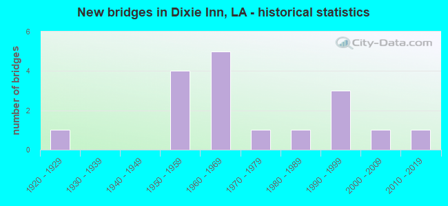
- New bridges - historical statistics
- 11920-1929
- 41950-1959
- 51960-1969
- 11970-1979
- 11980-1989
- 31990-1999
- 12000-2009
- 12010-2019

- Reconstructed bridges - Historical Statistics
- 11940-1949
- 01950-1959
- 01960-1969
- 01970-1979
- 41980-1989


- Bridge Condition - Deck
- 18.8%Good
- 37.5%Satisfactory
- 31.3%Fair
- 12.5%Poor

- Bridge Condition - Superstructure
- 6.3%Very good
- 18.8%Good
- 31.3%Satisfactory
- 25.0%Fair
- 18.8%Poor

- Bridge Condition - Substructure
- 6.3%Very good
- 12.5%Good
- 31.3%Satisfactory
- 31.3%Fair
- 18.8%Poor

- Bridge Condition - Channel
- 30.8%Very good
- 15.4%Good
- 30.8%Satisfactory
- 23.1%Fair
Find on map >> Show street view
Structure Number: 46000000040006, Location: 2.4 MI W OF JCT US 371 (Lat: 32.586319, Lng: -93.377161), Route carried "on" structure: US 80, Year Built: 2019, Status: Open, Structure Length: 2.44m (8.01ft), Average Daily Traffic: 4,204 (year 2017), Truck Traffic: 26%, Average Future Daily Traffic: 4,624 (year 2037), Design Load: Greater than HL93, Features Intersected: BOONE CREEK
Minimum Vertical Clearance: 30+ m (98+ ft), Kilometerpoint: 8.769, Lanes on structure: 2, Base Highway Network: Yes (Inventory Route: 1-04-2, Subroute: 10), Owner: State Highway Agency, Approaching Roadway Width: 9.8m (32.2ft), Skew: 10 degrees, Material/Design: Concrete, Design/Construction: Slab, Number Of Spans In Main Unit: 4, Length of Maximum Span: 6.1m (20.0ft), Curb-To-Curb Width: 9.9m (32.5ft), Out-to-Out Width: 10.7m (35.1ft)
Condition: Deck: Good, Superstructure: Very good, Substructure: Very good, Channel: Satisfactory, Operating Rating: 71.3 metric tons, Method Used To Determine Operating Rating: Load and Resistance Factor Rating (LRFR) rating reported by rating factor(RF) method using HL-93 loadings, Inventory Rating: 55.1 metric tons, Method Used To Determine Inventory Rating: Load and Resistance Factor Rating (LRFR) rating reported by rating factor(RF) method using HL-93 loadings, Structural Evaluation: Equal to present desirable criteria, Deck Geometry: Meets minimum limits, Waterway Adequacy: Equal to present desirable criteria, Approach Roadway Alignment: Equal to present desirable criteria, Designated Inspection Frequency: Every 24 months, Underwater Inspection Frequency: Every 60 months, Inspection Date: September 2021, Underwater Inspection Date: June 2020, Deck Structure Type: Concrete Precast Panels
Find on map >> Show street view
Structure Number: 46000000040462, Location: 0.28 MI NE OF US 371 (Lat: 32.596750, Lng: -93.334411), Route carried "on" structure: ServiceState highway 80, Year Built: 1925, Year Reconstructed: 1947, Status: Posted for load, Structure Length: 3.81m (12.50ft), Average Daily Traffic: 890 (year 2017), Average Future Daily Traffic: 990 (year 2038), Features Intersected: CREEK, Facility Carried by Structure: DORCHEAT ST.
Minimum Vertical Clearance: 30+ m (98+ ft), Kilometerpoint: 11.108, Lanes on structure: 2, Owner: State Highway Agency, Approaching Roadway Width: 6.1m (20.0ft), Material/Design: Concrete, Design/Construction: Stringer/Multi-beam, Number Of Spans In Main Unit: 5, Length of Maximum Span: 7.6m (24.9ft), Curb-To-Curb Width: 5.5m (18.0ft), Out-to-Out Width: 6.5m (21.3ft)
Condition: Deck: Fair, Superstructure: Fair, Substructure: Fair, Channel: Very good, Operating Rating: 17.5 metric tons, Method Used To Determine Operating Rating: Load and Resistance Factor Rating (LRFR) rating reported by rating factor(RF) method using HL-93 loadings, Inventory Rating: 13.6 metric tons, Method Used To Determine Inventory Rating: Load and Resistance Factor Rating (LRFR) rating reported by rating factor(RF) method using HL-93 loadings, Structural Evaluation: Meets minimum limits, Deck Geometry: High priority of replacement, Waterway Adequacy: Equal to present desirable criteria, Approach Roadway Alignment: Better than present minimum criteria, Bridge Posting: Required (Relationship of Operating Rating to Maximum Legal Load: 20.0 - 29.9% below), Designated Inspection Frequency: Every 24 months, Inspection Date: September 2020, Deck Structure Type: Concrete Cast-file-Place, Wearing Surface/Protective System: Wearing Surface: Bituminous
Find on map >> Show street view
Structure Number: 46000010404221, Location: 1.9 MI WEST OF US371 (Lat: 32.586111, Lng: -93.377400), Route carried "on" structure: US 80, Year Built: 1956, Status: Open, Structure Length: 2.44m (8.01ft), Average Daily Traffic: 3,250 (year 2016), Truck Traffic: 26%, Average Future Daily Traffic: 2,268 (year 2036), Design Load: HS 20, Features Intersected: BOONE CREEK
Minimum Vertical Clearance: 30+ m (98+ ft), Kilometerpoint: 6.742, Lanes on structure: 2, Base Highway Network: Yes (Inventory Route: 1-04-1, Subroute: 10), Owner: State Highway Agency, Approaching Roadway Width: 12.2m (40.0ft), Skew: 10 degrees, Material/Design: Concrete, Design/Construction: Slab, Number Of Spans In Main Unit: 4, Length of Maximum Span: 6.1m (20.0ft), Curb-To-Curb Width: 8.6m (28.2ft), Out-to-Out Width: 10.1m (33.1ft)
Condition: Deck: Fair, Superstructure: Fair, Substructure: Fair, Channel: Satisfactory, Operating Rating: 35.4 metric tons, Method Used To Determine Operating Rating: Load Factor (LF), Inventory Rating: 20.9 metric tons, Method Used To Determine Inventory Rating: Load Factor (LF), Structural Evaluation: Somewhat better than minimum adequacy, Deck Geometry: High priority of corrective action, Waterway Adequacy: Equal to present desirable criteria, Approach Roadway Alignment: Equal to present desirable criteria, Length Of Structure Improvement: 3.23m (10.60ft), Designated Inspection Frequency: Every 24 months, Inspection Date: September 2021, Bridge Improvement Cost: $275,000, Total Project Cost: $412,000 ( Estimate for 2016), Deck Structure Type: Concrete Cast-file-Place
Find on map >> Show street view
Structure Number: 46000010405461, Location: 1.16 MI WEST OF US 371 (Lat: 32.588150, Lng: -93.356500), Route carried "on" structure: US 80, Year Built: 2005, Status: Open, Structure Length: 8.99m (29.49ft), Average Daily Traffic: 6,500 (year 2016), Truck Traffic: 26%, Average Future Daily Traffic: 3,780 (year 2036), Design Load: HS 20, Features Intersected: KCS RAILROAD
Minimum Vertical Clearance: 30+ m (98+ ft), Kilometerpoint: 8.766, Lanes on structure: 2, Base Highway Network: Yes (Inventory Route: 1-04-1, Subroute: 10), Owner: State Highway Agency, Approaching Roadway Width: 13.7m (44.9ft), Skew: 4 degrees, Material/Design: Prestressed concrete continuous, Design/Construction: Stringer/Multi-beam, Number Of Spans In Main Unit: 3, Length of Maximum Span: 29.9m (98.1ft), Curb-To-Curb Width: 13.3m (43.6ft), Out-to-Out Width: 14.0m (45.9ft)
Condition: Deck: Good, Superstructure: Good, Substructure: Good, Operating Rating: 83.4 metric tons, Method Used To Determine Operating Rating: Load Factor (LF), Inventory Rating: 49.9 metric tons, Method Used To Determine Inventory Rating: Load Factor (LF), Structural Evaluation: Better than present minimum criteria, Deck Geometry: Somewhat better than minimum adequacy, Underclear: Superior to present desirable criteria, Approach Roadway Alignment: Equal to present minimum criteria, Designated Inspection Frequency: Every 24 months, Inspection Date: August 2021, Deck Structure Type: Concrete Cast-file-Place
Find on map >> Show street view
Structure Number: 46000010407021, Location: .2 MI EAST OF US 371 (Lat: 32.597261, Lng: -93.332300), Route carried "on" structure: US 80, Year Built: 1954, Status: Open, Structure Length: 8.60m (28.22ft), Average Daily Traffic: 10,400 (year 2016), Truck Traffic: 10%, Average Future Daily Traffic: 6,240 (year 2036), Design Load: HS 20, Features Intersected: BAYOU DORCHEAT
Minimum Vertical Clearance: 30+ m (98+ ft), Kilometerpoint: 11.309, Lanes on structure: 2, Owner: State Highway Agency, Approaching Roadway Width: 13.4m (44.0ft), Material/Design: Concrete, Design/Construction: Tee Beam, Number Of Spans In Main Unit: 8, Length of Maximum Span: 12.2m (40.0ft), Curb-To-Curb Width: 8.6m (28.2ft), Out-to-Out Width: 10.1m (33.1ft)
Condition: Deck: Fair, Superstructure: Poor, Substructure: Poor, Channel: Fair, Operating Rating: 27.2 metric tons, Method Used To Determine Operating Rating: Load and Resistance Factor Rating (LRFR) rating reported by rating factor(RF) method using HL-93 loadings, Inventory Rating: 21.1 metric tons, Method Used To Determine Inventory Rating: Load and Resistance Factor Rating (LRFR) rating reported by rating factor(RF) method using HL-93 loadings, Structural Evaluation: Meets minimum limits, Deck Geometry: Meets minimum limits, Waterway Adequacy: Equal to present desirable criteria, Approach Roadway Alignment: Equal to present desirable criteria, Length Of Structure Improvement: 9.51m (31.20ft), Designated Inspection Frequency: Every 24 months, Underwater Inspection Frequency: Every 60 months, Other Special Inspection Frequency: Every 12 months, Inspection Date: September 2021, Underwater Inspection Date: January 2020, Other Special Inspection Date: September 2020, Bridge Improvement Cost: $811,000, Total Project Cost: $1,216,000 ( Estimate for 2016), Deck Structure Type: Concrete Cast-file-Place
Find on map >> Show street view
Structure Number: 46000010407151, Location: .5 MI EAST OF US 371 (Lat: 32.598311, Lng: -93.330400), Route carried "on" structure: US 80, Year Built: 1954, Status: Open, Structure Length: 9.78m (32.09ft), Average Daily Traffic: 10,400 (year 2016), Truck Traffic: 10%, Average Future Daily Traffic: 6,240 (year 2036), Design Load: HS 20, Features Intersected: DORCHEAT RELIEF
Minimum Vertical Clearance: 30+ m (98+ ft), Kilometerpoint: 11.520, Lanes on structure: 2, Owner: State Highway Agency, Approaching Roadway Width: 13.4m (44.0ft), Material/Design: Concrete, Design/Construction: Slab, Number Of Spans In Main Unit: 16, Length of Maximum Span: 6.1m (20.0ft), Curb-To-Curb Width: 8.6m (28.2ft), Out-to-Out Width: 10.1m (33.1ft)
Condition: Deck: Poor, Superstructure: Poor, Substructure: Poor, Channel: Fair, Operating Rating: 24.3 metric tons, Method Used To Determine Operating Rating: Load and Resistance Factor Rating (LRFR) rating reported by rating factor(RF) method using HL-93 loadings, Inventory Rating: 18.8 metric tons, Method Used To Determine Inventory Rating: Load and Resistance Factor Rating (LRFR) rating reported by rating factor(RF) method using HL-93 loadings, Structural Evaluation: Meets minimum limits, Deck Geometry: Meets minimum limits, Waterway Adequacy: Equal to present desirable criteria, Approach Roadway Alignment: Equal to present desirable criteria, Length Of Structure Improvement: 10.70m (35.10ft), Designated Inspection Frequency: Every 24 months, Other Special Inspection Frequency: Every 12 months, Inspection Date: September 2021, Other Special Inspection Date: September 2020, Bridge Improvement Cost: $912,000, Total Project Cost: $1,368,000 ( Estimate for 2016), Deck Structure Type: Concrete Cast-file-Place
Find on map >> Show street view
Structure Number: 46000010407501, Location: .5 MI EAST OF US 371 (Lat: 32.601189, Lng: -93.325400), Route carried "on" structure: US 80, Year Built: 1954, Status: Open, Structure Length: 7.35m (24.11ft), Average Daily Traffic: 10,400 (year 2016), Truck Traffic: 10%, Average Future Daily Traffic: 6,240 (year 2036), Design Load: HS 20, Features Intersected: DORCHEAT RELIEF
Minimum Vertical Clearance: 30+ m (98+ ft), Kilometerpoint: 12.094, Lanes on structure: 2, Owner: State Highway Agency, Approaching Roadway Width: 13.4m (44.0ft), Material/Design: Concrete, Design/Construction: Slab, Number Of Spans In Main Unit: 12, Length of Maximum Span: 6.1m (20.0ft), Curb-To-Curb Width: 8.5m (27.9ft), Out-to-Out Width: 10.1m (33.1ft)
Condition: Deck: Poor, Superstructure: Poor, Substructure: Poor, Channel: Fair, Operating Rating: 29.8 metric tons, Method Used To Determine Operating Rating: Load and Resistance Factor Rating (LRFR) rating reported by rating factor(RF) method using HL-93 loadings, Inventory Rating: 23.0 metric tons, Method Used To Determine Inventory Rating: Load and Resistance Factor Rating (LRFR) rating reported by rating factor(RF) method using HL-93 loadings, Structural Evaluation: Meets minimum limits, Deck Geometry: Meets minimum limits, Waterway Adequacy: Better than present minimum criteria, Approach Roadway Alignment: Equal to present desirable criteria, Length Of Structure Improvement: 8.26m (27.10ft), Designated Inspection Frequency: Every 24 months, Other Special Inspection Frequency: Every 12 months, Inspection Date: September 2021, Other Special Inspection Date: September 2020, Bridge Improvement Cost: $704,000, Total Project Cost: $1,056,000 ( Estimate for 2016), Deck Structure Type: Concrete Cast-file-Place
Find on map >> Show street view
Structure Number: 46000860102441, Location: 2.44 MI NORTH OF US 80 (Lat: 32.616869, Lng: -93.355100), Route carried "on" structure: US 371, Year Built: 1960, Status: Open, Structure Length: 1.16m (3.81ft), Average Daily Traffic: 6,400 (year 2016), Truck Traffic: 26%, Average Future Daily Traffic: 3,780 (year 2036), Design Load: HS 20, Features Intersected: CREEK
Minimum Vertical Clearance: 30+ m (98+ ft), Kilometerpoint: 4.068, Lanes on structure: 2, Base Highway Network: Yes (Inventory Route: 86-01-1, Subroute: 10), Owner: State Highway Agency, Approaching Roadway Width: 12.8m (42.0ft), Material/Design: Concrete, Design/Construction: Culvert, Number Of Spans In Main Unit: 3, Length of Maximum Span: 2.4m (7.9ft), Curb-To-Curb Width: 11.6m (38.1ft), Out-to-Out Width: 12.8m (42.0ft)
Condition: Channel: Satisfactory, Culverts: Satisfactory, Operating Rating: 42.1 metric tons, Method Used To Determine Operating Rating: Load and Resistance Factor Rating (LRFR) rating reported by rating factor(RF) method using HL-93 loadings, Inventory Rating: 32.4 metric tons, Method Used To Determine Inventory Rating: Load and Resistance Factor Rating (LRFR) rating reported by rating factor(RF) method using HL-93 loadings, Structural Evaluation: Equal to present minimum criteria, Deck Geometry: Somewhat better than minimum adequacy, Waterway Adequacy: Better than present minimum criteria, Approach Roadway Alignment: Equal to present desirable criteria, Designated Inspection Frequency: Every 24 months, Inspection Date: September 2020, Deck Structure Type: Concrete Cast-file-Place
Find on map >> Show street view
Structure Number: 46004510303142, Location: 3.14 MI WEST OF US 371 (Lat: 32.583061, Lng: -93.390189), Route carried "on" structure: Interstate 20, Year Built: 1975, Status: Open, Structure Length: 16.79m (55.09ft), Average Daily Traffic: 24,050 (year 2016), Truck Traffic: 36%, Average Future Daily Traffic: 16,848 (year 2036), Design Load: HS 20, Features Intersected: US 80
Minimum Vertical Clearance: 30+ m (98+ ft), Kilometerpoint: 5.065, Lanes on structure: 2, Lanes under structure: 4, Base Highway Network: Yes (Inventory Route: 451-03-1, Subroute: 10), Owner: State Highway Agency, Approaching Roadway Width: 12.2m (40.0ft), Skew: 10 degrees, Material/Design: Steel continuous, Design/Construction: Girder and Floorbeam System, Number Of Spans In Main Unit: 4, Length of Maximum Span: 53.3m (174.9ft), Curb-To-Curb Width: 12.1m (39.7ft), Out-to-Out Width: 13.0m (42.7ft)
Condition: Deck: Satisfactory, Superstructure: Satisfactory, Substructure: Satisfactory, Operating Rating: 74.4 metric tons, Method Used To Determine Operating Rating: Load Factor (LF), Inventory Rating: 44.4 metric tons, Method Used To Determine Inventory Rating: Load Factor (LF), Structural Evaluation: Equal to present minimum criteria, Deck Geometry: Equal to present minimum criteria, Underclear: Better than present minimum criteria, Approach Roadway Alignment: Equal to present desirable criteria, Designated Inspection Frequency: Every 24 months, Inspection Date: September 2021, Deck Structure Type: Concrete Cast-file-Place
Find on map >> Show street view
Structure Number: 46004510304011, Location: 2.33 MI. W. OF LA 7 (Lat: 32.584161, Lng: -93.376000), Route carried "on" structure: Interstate 20, Year Built: 1961, Year Reconstructed: 1986, Status: Open, Structure Length: 4.88m (16.01ft), Average Daily Traffic: 24,050 (year 2016), Truck Traffic: 36%, Average Future Daily Traffic: 16,848 (year 2036), Design Load: HS 20, Features Intersected: BOONE CREEK
Minimum Vertical Clearance: 30+ m (98+ ft), Kilometerpoint: 6.639, Lanes on structure: 2, Base Highway Network: Yes (Inventory Route: 451-03-1, Subroute: 10), Owner: State Highway Agency, Approaching Roadway Width: 12.2m (40.0ft), Skew: 10 degrees, Material/Design: Concrete, Design/Construction: Slab, Number Of Spans In Main Unit: 8, Length of Maximum Span: 6.1m (20.0ft), Curb-To-Curb Width: 12.2m (40.0ft), Out-to-Out Width: 13.0m (42.7ft)
Condition: Deck: Fair, Superstructure: Fair, Substructure: Fair, Channel: Very good, Operating Rating: 81.6 metric tons, Method Used To Determine Operating Rating: Load Factor (LF), Inventory Rating: 49.0 metric tons, Method Used To Determine Inventory Rating: Load Factor (LF), Structural Evaluation: Somewhat better than minimum adequacy, Deck Geometry: Better than present minimum criteria, Waterway Adequacy: Equal to present desirable criteria, Approach Roadway Alignment: Equal to present desirable criteria, Designated Inspection Frequency: Every 24 months, Inspection Date: September 2020, Deck Structure Type: Concrete Cast-file-Place
Find on map >> Show street view
Structure Number: 46004510304012, Location: 2.33 MI WEST OF LA 7 (Lat: 32.584450, Lng: -93.375500), Route carried "on" structure: Interstate 20, Year Built: 1987, Status: Open, Structure Length: 4.88m (16.01ft), Average Daily Traffic: 24,050 (year 2016), Truck Traffic: 36%, Average Future Daily Traffic: 16,848 (year 2036), Design Load: HS 20, Features Intersected: BOONE CREEK
Minimum Vertical Clearance: 30+ m (98+ ft), Kilometerpoint: 19.348, Lanes on structure: 2, Base Highway Network: Yes (Inventory Route: 451-03-2, Subroute: 10), Owner: State Highway Agency, Approaching Roadway Width: 12.2m (40.0ft), Skew: 10 degrees, Material/Design: Concrete, Design/Construction: Slab, Number Of Spans In Main Unit: 8, Length of Maximum Span: 6.1m (20.0ft), Curb-To-Curb Width: 12.2m (40.0ft), Out-to-Out Width: 13.0m (42.7ft)
Condition: Deck: Fair, Superstructure: Fair, Substructure: Fair, Channel: Very good, Operating Rating: 53.5 metric tons, Method Used To Determine Operating Rating: Load Factor (LF), Inventory Rating: 32.7 metric tons, Method Used To Determine Inventory Rating: Load Factor (LF), Structural Evaluation: Somewhat better than minimum adequacy, Deck Geometry: Better than present minimum criteria, Waterway Adequacy: Equal to present desirable criteria, Approach Roadway Alignment: Equal to present desirable criteria, Designated Inspection Frequency: Every 24 months, Inspection Date: September 2020, Deck Structure Type: Concrete Cast-file-Place
Find on map >> Show street view
Structure Number: 46004510306341, Location: I-20 OVER US 371 (Lat: 32.590189, Lng: -93.336700), Route carried "on" structure: Interstate 20, Year Built: 1960, Year Reconstructed: 1992, Status: Open, Structure Length: 5.79m (19.00ft), Average Daily Traffic: 22,100 (year 2016), Truck Traffic: 19%, Average Future Daily Traffic: 15,480 (year 2036), Design Load: HS 20, Features Intersected: LA 7 @ DIXIE INN
Minimum Vertical Clearance: 30+ m (98+ ft), Kilometerpoint: 10.395, Lanes on structure: 2, Lanes under structure: 4, Base Highway Network: Yes (Inventory Route: 451-03-1, Subroute: 10), Owner: State Highway Agency, Approaching Roadway Width: 11.6m (38.1ft), Skew: 10 degrees, Material/Design: Steel, Design/Construction: Stringer/Multi-beam, Number Of Spans In Main Unit: 5, Length of Maximum Span: 21.3m (69.9ft), Curb-To-Curb Width: 15.9m (52.2ft), Out-to-Out Width: 16.7m (54.8ft)
Condition: Deck: Satisfactory, Superstructure: Satisfactory, Substructure: Fair, Operating Rating: 54.4 metric tons, Method Used To Determine Operating Rating: Load Factor (LF), Inventory Rating: 32.7 metric tons, Method Used To Determine Inventory Rating: Load Factor (LF), Structural Evaluation: Somewhat better than minimum adequacy, Deck Geometry: Superior to present desirable criteria, Underclear: High priority of corrective action, Approach Roadway Alignment: Equal to present desirable criteria, Designated Inspection Frequency: Every 24 months, Inspection Date: September 2020, Deck Structure Type: Concrete Cast-file-Place
Find on map >> Show street view
Structure Number: 46004510306342, Location: I-20 OVER US 371 (Lat: 32.590589, Lng: -93.336200), Route carried "on" structure: Interstate 20, Year Built: 1960, Year Reconstructed: 1993, Status: Open, Structure Length: 5.79m (19.00ft), Average Daily Traffic: 22,100 (year 2016), Truck Traffic: 19%, Average Future Daily Traffic: 15,480 (year 2036), Design Load: HS 20, Features Intersected: LA 7 @ DIXIE INN
Minimum Vertical Clearance: 30+ m (98+ ft), Kilometerpoint: 15.586, Lanes on structure: 2, Lanes under structure: 4, Base Highway Network: Yes (Inventory Route: 451-03-2, Subroute: 10), Owner: State Highway Agency, Approaching Roadway Width: 11.6m (38.1ft), Skew: 10 degrees, Material/Design: Steel, Design/Construction: Stringer/Multi-beam, Number Of Spans In Main Unit: 1, Number Of Approach Spans: 4, Length of Maximum Span: 21.3m (69.9ft), Curb-To-Curb Width: 12.2m (40.0ft), Out-to-Out Width: 13.0m (42.7ft)
Condition: Deck: Satisfactory, Superstructure: Good, Substructure: Satisfactory, Operating Rating: 54.4 metric tons, Method Used To Determine Operating Rating: Load Factor (LF), Inventory Rating: 32.7 metric tons, Method Used To Determine Inventory Rating: Load Factor (LF), Structural Evaluation: Equal to present minimum criteria, Deck Geometry: Better than present minimum criteria, Underclear: High priority of corrective action, Approach Roadway Alignment: Equal to present desirable criteria, Designated Inspection Frequency: Every 24 months, Inspection Date: September 2021, Deck Structure Type: Concrete Cast-file-Place
Find on map >> Show street view
Structure Number: 46004510306781, Location: 0.44M EAST OF LA 7 (Lat: 32.592181, Lng: -93.329500), Route carried "on" structure: Interstate 20, Year Built: 1992, Status: Open, Structure Length: 7.32m (24.02ft), Average Daily Traffic: 22,100 (year 2016), Truck Traffic: 19%, Average Future Daily Traffic: 15,480 (year 2036), Design Load: HS 20, Features Intersected: DORCHEAR BAYOU REL
Minimum Vertical Clearance: 30+ m (98+ ft), Kilometerpoint: 11.106, Lanes on structure: 2, Base Highway Network: Yes (Inventory Route: 451-03-1, Subroute: 10), Owner: State Highway Agency, Approaching Roadway Width: 11.6m (38.1ft), Skew: 10 degrees, Material/Design: Prestressed concrete, Design/Construction: Stringer/Multi-beam, Number Of Spans In Main Unit: 6, Length of Maximum Span: 12.2m (40.0ft), Curb-To-Curb Width: 12.2m (40.0ft), Out-to-Out Width: 13.0m (42.7ft)
Condition: Deck: Satisfactory, Superstructure: Satisfactory, Substructure: Satisfactory, Channel: Good, Operating Rating: 68.0 metric tons, Method Used To Determine Operating Rating: Load Factor (LF), Inventory Rating: 38.1 metric tons, Method Used To Determine Inventory Rating: Load Factor (LF), Structural Evaluation: Equal to present minimum criteria, Deck Geometry: Better than present minimum criteria, Waterway Adequacy: Equal to present desirable criteria, Approach Roadway Alignment: Equal to present desirable criteria, Designated Inspection Frequency: Every 24 months, Inspection Date: September 2020, Deck Structure Type: Concrete Cast-file-Place
Find on map >> Show street view
Structure Number: 46004510306782, Location: 0.44M EAST OF LA 7 (Lat: 32.592611, Lng: -93.328900), Route carried "on" structure: Interstate 20, Year Built: 1960, Year Reconstructed: 1993, Status: Open, Structure Length: 7.32m (24.02ft), Average Daily Traffic: 22,100 (year 2016), Truck Traffic: 19%, Average Future Daily Traffic: 15,480 (year 2036), Design Load: HS 20, Features Intersected: DORCHEAT BAYOU REL
Minimum Vertical Clearance: 30+ m (98+ ft), Kilometerpoint: 14.862, Lanes on structure: 2, Base Highway Network: Yes (Inventory Route: 451-03-2, Subroute: 10), Owner: State Highway Agency, Approaching Roadway Width: 11.6m (38.1ft), Skew: 10 degrees, Material/Design: Prestressed concrete, Design/Construction: Stringer/Multi-beam, Number Of Spans In Main Unit: 6, Length of Maximum Span: 12.2m (40.0ft), Curb-To-Curb Width: 12.2m (40.0ft), Out-to-Out Width: 13.0m (42.7ft)
Condition: Deck: Satisfactory, Superstructure: Satisfactory, Substructure: Good, Channel: Very good, Operating Rating: 68.0 metric tons, Method Used To Determine Operating Rating: Load Factor (LF), Inventory Rating: 38.1 metric tons, Method Used To Determine Inventory Rating: Load Factor (LF), Structural Evaluation: Equal to present minimum criteria, Deck Geometry: Better than present minimum criteria, Waterway Adequacy: Superior to present desirable criteria, Approach Roadway Alignment: Equal to present desirable criteria, Designated Inspection Frequency: Every 24 months, Inspection Date: September 2021, Deck Structure Type: Concrete Cast-file-Place
Find on map >> Show street view
Structure Number: 46004510307181, Location: 0.84 MI. E. OF LA 7 (Lat: 32.593831, Lng: -93.323100), Route carried "on" structure: Interstate 20, Year Built: 1992, Status: Open, Structure Length: 18.29m (60.01ft), Average Daily Traffic: 22,100 (year 2016), Truck Traffic: 19%, Average Future Daily Traffic: 15,480 (year 2036), Design Load: HS 20, Features Intersected: DORCHEAT BAYOU
Minimum Vertical Clearance: 30+ m (98+ ft), Kilometerpoint: 11.742, Lanes on structure: 2, Base Highway Network: Yes (Inventory Route: 451-03-1, Subroute: 10), Owner: State Highway Agency, Approaching Roadway Width: 11.6m (38.1ft), Skew: 10 degrees, Material/Design: Prestressed concrete, Design/Construction: Stringer/Multi-beam, Number Of Spans In Main Unit: 10, Length of Maximum Span: 18.3m (60.0ft), Curb-To-Curb Width: 12.2m (40.0ft), Out-to-Out Width: 13.1m (43.0ft)
Condition: Deck: Satisfactory, Superstructure: Satisfactory, Substructure: Satisfactory, Channel: Good, Operating Rating: 63.5 metric tons, Method Used To Determine Operating Rating: Load Factor (LF), Inventory Rating: 38.1 metric tons, Method Used To Determine Inventory Rating: Load Factor (LF), Structural Evaluation: Equal to present minimum criteria, Deck Geometry: Better than present minimum criteria, Waterway Adequacy: Equal to present desirable criteria, Approach Roadway Alignment: Equal to present desirable criteria, Designated Inspection Frequency: Every 24 months, Underwater Inspection Frequency: Every 60 months, Inspection Date: September 2020, Underwater Inspection Date: Febuary 2018, Deck Structure Type: Concrete Cast-file-Place
Find on map >> Show street view
Structure Number: 46032342932251, Location: 3.0 MI SE OF US 80 (Lat: 32.570169, Lng: -93.375550), Route carried "on" structure: County highway , Year Built: 1991, Status: Open, Structure Length: 4.18m (13.71ft), Average Daily Traffic: 30 (year 2021), Average Future Daily Traffic: 33 (year 2041), Design Load: HS 20, Features Intersected: BOONE CREEK, Facility Carried by Structure: Burma Rd
Minimum Vertical Clearance: 30+ m (98+ ft), Kilometerpoint: 0.000, Lanes on structure: 2, Base Highway Network: Yes, Owner: State Agenciy, Approaching Roadway Width: 6.1m (20.0ft), Skew: 4 degrees, Material/Design: Prestressed concrete, Design/Construction: Channel Beam, Number Of Spans In Main Unit: 4, Length of Maximum Span: 10.4m (34.1ft), Curb-To-Curb Width: 8.7m (28.5ft), Out-to-Out Width: 9.4m (30.8ft)
Condition: Deck: Good, Superstructure: Good, Substructure: Satisfactory, Channel: Satisfactory, Operating Rating: 44.1 metric tons, Method Used To Determine Operating Rating: Load and Resistance Factor Rating (LRFR) rating reported by rating factor(RF) method using HL-93 loadings, Inventory Rating: 34.0 metric tons, Method Used To Determine Inventory Rating: Load and Resistance Factor Rating (LRFR) rating reported by rating factor(RF) method using HL-93 loadings, Structural Evaluation: Equal to present minimum criteria, Deck Geometry: Better than present minimum criteria, Waterway Adequacy: Equal to present desirable criteria, Approach Roadway Alignment: Equal to present desirable criteria, Designated Inspection Frequency: Every 24 months, Inspection Date: August 2021, Deck Structure Type: Concrete Cast-file-Place
Find on map >> Show street view
Structure Number: 46004510306341, Location: 2.6 MI W OF MINDEN (Lat: 32.590150, Lng: -93.336461), Route carried "under" structure: Interstate 20, Structure Length: 0. m, Average Daily Traffic: 25,800 (year 2015), Features Intersected: 371 S UNDER I-20 EB
Minimum Vertical Clearance: 5.06m (16.60ft), Kilometerpoint: 0.195, Lanes on structure: 2, Length of Maximum Span: 0.0m
Find on map >> Show street view
Structure Number: 46004510306341, Location: 2.6 MI W OF MINDEN (Lat: 32.590169, Lng: -93.336369), Route carried "under" structure: Interstate 20, Structure Length: 0. m, Average Daily Traffic: 25,800 (year 2015), Features Intersected: UNDER I-20 EB
Minimum Vertical Clearance: 5.06m (16.60ft), Kilometerpoint: 0.592, Lanes on structure: 2, Length of Maximum Span: 0.0m
Find on map >> Show street view
Structure Number: 46004510306342, Location: 2.6 MI W OF MINDEN (Lat: 32.590450, Lng: -93.336461), Route carried "under" structure: Interstate 20, Structure Length: 0. m, Average Daily Traffic: 25,800 (year 2015), Features Intersected: 371 N UNDER I-20 WB
Minimum Vertical Clearance: 5.09m (16.70ft), Kilometerpoint: 0.624, Lanes on structure: 2, Length of Maximum Span: 0.0m
Find on map >> Show street view
Structure Number: 46004510306342, Location: 2.6 MI W OF MINDEN (Lat: 32.590589, Lng: -93.336600), Route carried "under" structure: Interstate 20, Structure Length: 0. m, Average Daily Traffic: 25,800 (year 2015), Features Intersected: UNDER I-20 WB
Minimum Vertical Clearance: 5.03m (16.50ft), Kilometerpoint: 0.145, Lanes on structure: 2, Length of Maximum Span: 0.0m