Bridge Statistics for Doolittle, Missouri (MO)
Condition, Traffic, Stress, Structural Evaluation, Project Costs
- National Bridge Inventory (NBI) Statistics
- 17Number of bridges
- 400ft / 122mTotal length
- $693,000Total costs
- 151,282Total average daily traffic
- 53,706Total average daily truck traffic
- National Bridge Inventory (NBI) Registered Bridges for Doolittle
- No street view available for this location
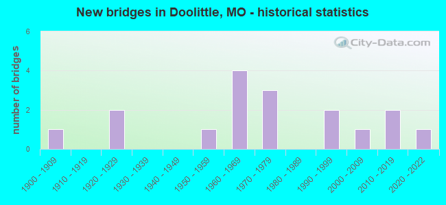
- New bridges - historical statistics
- 11900-1909
- 21920-1929
- 11950-1959
- 41960-1969
- 31970-1979
- 21990-1999
- 12000-2009
- 22010-2019
- 12020-2022

- Reconstructed bridges - Historical Statistics
- 21940-1949
- 01950-1959
- 01960-1969
- 01970-1979
- 21980-1989
- 01990-1999
- 12000-2009


- Bridge Condition - Deck
- 36.4%Very good
- 18.2%Good
- 36.4%Satisfactory
- 9.1%Fair

- Bridge Condition - Superstructure
- 36.4%Very good
- 27.3%Good
- 27.3%Satisfactory
- 9.1%Fair

- Bridge Condition - Substructure
- 18.2%Excellent
- 18.2%Very good
- 9.1%Good
- 45.5%Satisfactory
- 9.1%Fair

- Bridge Condition - Channel
- 10.0%Very good
- 30.0%Good
- 50.0%Satisfactory
- 10.0%Fair
Find on map >> Show street view
Structure Number: 132, Location: S 8 T 37 N R 9 W (Lat: 37.943572, Lng: -91.936500), Route carried "on" structure: County highway 8490, Year Built: 1966, Status: Open, Structure Length: 6.34m (20.80ft), Average Daily Traffic: 262 (year 2021), Truck Traffic: 11%, Average Future Daily Traffic: 393 (year 2041), Design Load: H 15, Features Intersected: IS 44
Minimum Vertical Clearance: 30+ m (98+ ft), Kilometerpoint: 7.191, Lanes on structure: 2, Lanes under structure: 4, Owner: State Highway Agency, Approaching Roadway Width: 7.3m (24.0ft), Skew: 2 degrees, Material/Design: Concrete continuous, Design/Construction: Slab, Number Of Spans In Main Unit: 4, Length of Maximum Span: 18.6m (61.0ft), Curb-To-Curb Width: 8.5m (27.9ft), Out-to-Out Width: 9.4m (30.8ft)
Condition: Deck: Satisfactory, Superstructure: Satisfactory, Substructure: Good, Operating Rating: 38.7 metric tons, Method Used To Determine Operating Rating: Allowable Stress (AS), Inventory Rating: 19.8 metric tons, Method Used To Determine Inventory Rating: Allowable Stress (AS), Structural Evaluation: Somewhat better than minimum adequacy, Deck Geometry: Equal to present minimum criteria, Underclear: Meets minimum limits, Approach Roadway Alignment: Equal to present desirable criteria, Designated Inspection Frequency: Every 24 months, Inspection Date: May 2021, Deck Structure Type: Concrete Cast-file-Place, Wearing Surface/Protective System: Wearing Surface: Epoxy Overlay, Membrane: Built-up, Deck Protection: Bituminous
Find on map >> Show street view
Structure Number: 20477, Location: S 30 T 37 N R 8 W (Lat: 37.896200, Lng: -91.853500), Route carried "on" structure: County highway 261, Year Built: 1992, Status: Open, Structure Length: 5.03m (16.50ft), Average Daily Traffic: 70 (year 2020), Truck Traffic: 10%, Average Future Daily Traffic: 91 (year 2040), Design Load: HS 20, Features Intersected: LITTLE PINEY CR, Facility Carried by Structure: COUNTY RD 7360
Minimum Vertical Clearance: 30+ m (98+ ft), Kilometerpoint: 4.023, Lanes on structure: 2, Owner: County Highway Agency, Approaching Roadway Width: 7.3m (24.0ft), Material/Design: Concrete continuous, Design/Construction: Slab, Number Of Spans In Main Unit: 5, Length of Maximum Span: 10.7m (35.1ft), Curb-To-Curb Width: 7.3m (24.0ft), Out-to-Out Width: 8.0m (26.2ft)
Condition: Deck: Good, Superstructure: Good, Substructure: Fair, Channel: Fair, Operating Rating: 49.5 metric tons, Method Used To Determine Operating Rating: Allowable Stress (AS), Inventory Rating: 32.4 metric tons, Method Used To Determine Inventory Rating: Allowable Stress (AS), Structural Evaluation: Somewhat better than minimum adequacy, Deck Geometry: Equal to present minimum criteria, Waterway Adequacy: Equal to present minimum criteria, Approach Roadway Alignment: Equal to present desirable criteria, Designated Inspection Frequency: Every 24 months, Inspection Date: November 2021, Deck Structure Type: Concrete Cast-file-Place, Wearing Surface/Protective System: Wearing Surface: Monolithic Concrete
Find on map >> Show street view
Structure Number: 20479, Location: S 29 T 37 N R 8 W (Lat: 37.895000, Lng: -91.836100), Route carried "on" structure: County highway 261, Year Built: 1900, Year Reconstructed: 1989, Status: Open, Structure Length: 1.62m (5.31ft), Average Daily Traffic: 40 (year 2020), Truck Traffic: 10%, Average Future Daily Traffic: 52 (year 2040), Design Load: HS 20, Features Intersected: BEAVER CR, Facility Carried by Structure: COUNTY RD 7360
Minimum Vertical Clearance: 30+ m (98+ ft), Kilometerpoint: 5.311, Lanes on structure: 1, Owner: County Highway Agency, Approaching Roadway Width: 4.3m (14.1ft), Material/Design: Prestressed concrete, Design/Construction: Tee Beam, Number Of Spans In Main Unit: 1, Length of Maximum Span: 15.2m (49.9ft), Curb-To-Curb Width: 4.7m (15.4ft), Out-to-Out Width: 4.9m (16.1ft)
Condition: Deck: Very good, Superstructure: Very good, Substructure: Very good, Channel: Satisfactory, Operating Rating: 58.5 metric tons, Method Used To Determine Operating Rating: Allowable Stress (AS), Inventory Rating: 32.4 metric tons, Method Used To Determine Inventory Rating: Allowable Stress (AS), Structural Evaluation: Equal to present desirable criteria, Deck Geometry: Better than present minimum criteria, Waterway Adequacy: Better than present minimum criteria, Approach Roadway Alignment: Somewhat better than minimum adequacy, Designated Inspection Frequency: Every 24 months, Inspection Date: November 2021, Deck Structure Type: Concrete Cast-file-Place, Wearing Surface/Protective System: Wearing Surface: Monolithic Concrete
Find on map >> Show street view
Structure Number: 2603, Location: S 11 T 37 N R 9 W (Lat: 37.944964, Lng: -91.883358), Route carried "on" structure: State highway C, Year Built: 1976, Status: Open, Structure Length: 7.19m (23.59ft), Average Daily Traffic: 434 (year 2021), Truck Traffic: 11%, Average Future Daily Traffic: 651 (year 2041), Design Load: H 20, Features Intersected: IS 44
Minimum Vertical Clearance: 30+ m (98+ ft), Kilometerpoint: 12.518, Lanes on structure: 2, Lanes under structure: 4, Owner: State Highway Agency, Approaching Roadway Width: 13.4m (44.0ft), Skew: 1 degrees, Material/Design: Steel continuous, Design/Construction: Stringer/Multi-beam, Number Of Spans In Main Unit: 2, Length of Maximum Span: 30.7m (100.7ft), Curb-To-Curb Width: 13.4m (44.0ft), Out-to-Out Width: 14.3m (46.9ft)
Condition: Deck: Satisfactory, Superstructure: Satisfactory, Substructure: Satisfactory, Operating Rating: 47.7 metric tons, Method Used To Determine Operating Rating: Allowable Stress (AS), Inventory Rating: 27.9 metric tons, Method Used To Determine Inventory Rating: Allowable Stress (AS), Structural Evaluation: Equal to present minimum criteria, Deck Geometry: Superior to present desirable criteria, Underclear: Somewhat better than minimum adequacy, Approach Roadway Alignment: Equal to present desirable criteria, Designated Inspection Frequency: Every 24 months, Inspection Date: May 2021, Deck Structure Type: Concrete Cast-file-Place, Wearing Surface/Protective System: Wearing Surface: Bituminous
Find on map >> Show street view
Structure Number: 29214, Location: S 24 T 37 N R 10 W (Lat: 37.918708, Lng: -91.969931), Route carried "on" structure: Interstate 44, Year Built: 2002, Status: Open, Structure Length: 34.01m (111.58ft), Average Daily Traffic: 17,789 (year 2021), Truck Traffic: 44%, Average Future Daily Traffic: 33,799 (year 2041), Design Load: HS 20+Mod, Features Intersected: LIT PINEY RVR, BNSF RR
Minimum Vertical Clearance: 30+ m (98+ ft), Kilometerpoint: 191.794, Lanes on structure: 2, Base Highway Network: Yes, Owner: State Highway Agency, Approaching Roadway Width: 11.6m (38.1ft), Skew: 1 degrees, Material/Design: Steel continuous, Design/Construction: Stringer/Multi-beam, Number Of Spans In Main Unit: 8, Length of Maximum Span: 50.3m (165.0ft), Curb-To-Curb Width: 11.6m (38.1ft), Out-to-Out Width: 12.4m (40.7ft)
Condition: Deck: Satisfactory, Superstructure: Good, Substructure: Satisfactory, Channel: Good, Operating Rating: 82.8 metric tons, Method Used To Determine Operating Rating: Load Factor (LF), Inventory Rating: 50.4 metric tons, Method Used To Determine Inventory Rating: Load Factor (LF), Structural Evaluation: Equal to present minimum criteria, Deck Geometry: Equal to present minimum criteria, Underclear: Equal to present desirable criteria, Waterway Adequacy: Superior to present desirable criteria, Approach Roadway Alignment: Equal to present desirable criteria, Designated Inspection Frequency: Every 24 months, Inspection Date: January 2022, Deck Structure Type: Concrete Cast-file-Place, Wearing Surface/Protective System: Wearing Surface: Monolithic Concrete, Deck Protection: Epoxy Coated Reinforcing
Find on map >> Show street view
Structure Number: 35143, Location: S 17 T 37 N R 8 W (Lat: 37.929722, Lng: -91.838889), Route carried "on" structure: County highway 253, Year Built: 2016, Status: Open, Structure Length: 2.14m (7.02ft), Average Daily Traffic: 70 (year 2020), Truck Traffic: 10%, Average Future Daily Traffic: 91 (year 2040), Features Intersected: LIT BEAVER CR, Facility Carried by Structure: COUNTY RD 7050
Minimum Vertical Clearance: 30+ m (98+ ft), Kilometerpoint: 0.161, Lanes on structure: 2, Owner: County Highway Agency, Approaching Roadway Width: 7.3m (24.0ft), Skew: 1 degrees, Material/Design: Concrete, Design/Construction: Channel Beam, Number Of Spans In Main Unit: 2, Length of Maximum Span: 9.8m (32.2ft), Curb-To-Curb Width: 7.0m (23.0ft), Out-to-Out Width: 7.3m (24.0ft)
Condition: Deck: Very good, Superstructure: Very good, Substructure: Very good, Channel: Satisfactory, Operating Rating: 54.0 metric tons, Method Used To Determine Operating Rating: Load Factor (LF), Inventory Rating: 32.4 metric tons, Method Used To Determine Inventory Rating: Load Factor (LF), Structural Evaluation: Equal to present desirable criteria, Deck Geometry: Somewhat better than minimum adequacy, Waterway Adequacy: Better than present minimum criteria, Approach Roadway Alignment: High priority of corrective action, Designated Inspection Frequency: Every 24 months, Inspection Date: November 2021, Deck Structure Type: Concrete Precast Panels, Wearing Surface/Protective System: Wearing Surface: Monolithic Concrete
Find on map >> Show street view
Structure Number: 35639, Location: S 13 T 37 N R 10 W (Lat: 37.921831, Lng: -91.978506), Route carried "on" structure: State highway D, Year Built: 2017, Status: Open, Structure Length: 5.56m (18.24ft), Average Daily Traffic: 1,781 (year 2021), Truck Traffic: 11%, Average Future Daily Traffic: 2,672 (year 2041), Features Intersected: BNSF RR
Minimum Vertical Clearance: 30+ m (98+ ft), Kilometerpoint: 12.165, Lanes on structure: 2, Owner: State Highway Agency, Approaching Roadway Width: 8.5m (27.9ft), Material/Design: Prestressed concrete continuous, Design/Construction: Box Beam or Girders - Single/Spread, Number Of Spans In Main Unit: 3, Length of Maximum Span: 21.0m (68.9ft), Curb-To-Curb Width: 8.5m (27.9ft), Out-to-Out Width: 9.3m (30.5ft)
Condition: Deck: Very good, Superstructure: Very good, Substructure: Excellent, Operating Rating: 93.6 metric tons, Method Used To Determine Operating Rating: Load Factor (LF), Inventory Rating: 55.8 metric tons, Method Used To Determine Inventory Rating: Load Factor (LF), Structural Evaluation: Equal to present desirable criteria, Deck Geometry: Somewhat better than minimum adequacy, Underclear: Superior to present desirable criteria, Approach Roadway Alignment: Equal to present desirable criteria, Designated Inspection Frequency: Every 24 months, Inspection Date: May 2021, Deck Structure Type: Concrete Cast-file-Place, Wearing Surface/Protective System: Wearing Surface: Monolithic Concrete, Deck Protection: Epoxy Coated Reinforcing
Find on map >> Show street view
Structure Number: 364, Location: S 17 T 37 N R 8 W (Lat: 37.932500, Lng: -91.838611), Route carried "on" structure: County highway 254, Year Built: 2020, Status: Open, Structure Length: 2.74m (8.99ft), Average Daily Traffic: 220 (year 2020), Truck Traffic: 10%, Average Future Daily Traffic: 286 (year 2040), Design Load: HS 20+Mod, Features Intersected: LIT BEAVER CR, Facility Carried by Structure: COUNTY RD 7100
Minimum Vertical Clearance: 30+ m (98+ ft), Kilometerpoint: 1.609, Lanes on structure: 2, Owner: County Highway Agency, Approaching Roadway Width: 7.3m (24.0ft), Skew: 1 degrees, Material/Design: Prestressed concrete, Design/Construction: Tee Beam, Number Of Spans In Main Unit: 1, Length of Maximum Span: 26.3m (86.3ft), Curb-To-Curb Width: 7.9m (25.9ft), Out-to-Out Width: 8.5m (27.9ft)
Condition: Deck: Very good, Superstructure: Very good, Substructure: Excellent, Channel: Very good, Operating Rating: 68.4 metric tons, Method Used To Determine Operating Rating: Load Factor (LF), Inventory Rating: 53.1 metric tons, Method Used To Determine Inventory Rating: Load Factor (LF), Structural Evaluation: Equal to present desirable criteria, Deck Geometry: Somewhat better than minimum adequacy, Waterway Adequacy: Superior to present desirable criteria, Approach Roadway Alignment: Equal to present desirable criteria, Designated Inspection Frequency: Every 24 months, Inspection Date: November 2021, Deck Structure Type: Concrete Precast Panels, Wearing Surface/Protective System: Wearing Surface: Monolithic Concrete, Deck Protection: Epoxy Coated Reinforcing
Find on map >> Show street view
Structure Number: 4143, Location: S 24 T 37 N R 10 W (Lat: 37.919503, Lng: -91.975919), Route carried "on" structure: State highway D, Year Built: 1996, Status: Open, Structure Length: 16.98m (55.71ft), Average Daily Traffic: 1,781 (year 2021), Truck Traffic: 11%, Average Future Daily Traffic: 2,672 (year 2041), Design Load: HS 20, Features Intersected: GASCONADE RVR
Minimum Vertical Clearance: 30+ m (98+ ft), Kilometerpoint: 12.469, Lanes on structure: 2, Owner: State Highway Agency, Approaching Roadway Width: 8.5m (27.9ft), Material/Design: Prestressed concrete continuous, Design/Construction: Tee Beam, Number Of Spans In Main Unit: 6, Length of Maximum Span: 39.6m (129.9ft), Curb-To-Curb Width: 11.8m (38.7ft), Out-to-Out Width: 12.6m (41.3ft)
Condition: Deck: Satisfactory, Superstructure: Good, Substructure: Satisfactory, Channel: Satisfactory, Operating Rating: 64.8 metric tons, Method Used To Determine Operating Rating: Load Factor (LF), Inventory Rating: 38.7 metric tons, Method Used To Determine Inventory Rating: Load Factor (LF), Structural Evaluation: Equal to present minimum criteria, Deck Geometry: Equal to present minimum criteria, Waterway Adequacy: Equal to present desirable criteria, Approach Roadway Alignment: Equal to present desirable criteria, Designated Inspection Frequency: Every 24 months, Underwater Inspection Frequency: Every 60 months, Inspection Date: April 2021, Underwater Inspection Date: July 2018, Deck Structure Type: Concrete Cast-file-Place, Wearing Surface/Protective System: Wearing Surface: Monolithic Concrete, Deck Protection: Epoxy Coated Reinforcing
Find on map >> Show street view
Structure Number: 4678, Location: S 8 T 37 N R 8 W (Lat: 37.938333, Lng: -91.833431), Route carried "on" structure: Interstate 44, Year Built: 1925, Year Reconstructed: 1954, Status: Open, Structure Length: 1.55m (5.09ft), Average Daily Traffic: 32,302 (year 2021), Truck Traffic: 29%, Average Future Daily Traffic: 61,374 (year 2041), Design Load: H 20, Features Intersected: LIT BEAVER CR
Minimum Vertical Clearance: 30+ m (98+ ft), Kilometerpoint: 293.320, Lanes on structure: 4, Base Highway Network: Yes, Owner: State Highway Agency, Approaching Roadway Width: 32.9m (107.9ft), Skew: 20 degrees, Material/Design: Concrete continuous, Design/Construction: Culvert, Number Of Spans In Main Unit: 4, Length of Maximum Span: 3.7m (12.1ft)
Condition: Channel: Good, Culverts: Satisfactory, Operating Rating: 72.0 metric tons, Method Used To Determine Operating Rating: Field evaluation and documented engineering judgment, Inventory Rating: 43.2 metric tons, Method Used To Determine Inventory Rating: Field evaluation and documented engineering judgment, Structural Evaluation: Equal to present minimum criteria, Waterway Adequacy: Equal to present minimum criteria, Approach Roadway Alignment: Equal to present desirable criteria, Designated Inspection Frequency: Every 24 months, Inspection Date: May 2021
Find on map >> Show street view
Structure Number: 4818, Location: S 24 T 37 N R 10 W (Lat: 37.918761, Lng: -91.969589), Route carried "on" structure: Interstate 44, Year Built: 1966, Year Reconstructed: 2008, Status: Open, Structure Length: 33.28m (109.19ft), Average Daily Traffic: 14,858 (year 2021), Truck Traffic: 42%, Average Future Daily Traffic: 28,230 (year 2041), Design Load: HS 20, Features Intersected: LIT PINEY RVR, BNSF RR
Minimum Vertical Clearance: 30+ m (98+ ft), Kilometerpoint: 279.671, Lanes on structure: 2, Base Highway Network: Yes, Owner: State Highway Agency, Approaching Roadway Width: 12.2m (40.0ft), Material/Design: Steel continuous, Design/Construction: Stringer/Multi-beam, Number Of Spans In Main Unit: 4, Number Of Approach Spans: 4, Length of Maximum Span: 57.9m (190.0ft), Curb-To-Curb Width: 9.8m (32.2ft), Out-to-Out Width: 10.6m (34.8ft)
Condition: Deck: Good, Superstructure: Satisfactory, Substructure: Satisfactory, Channel: Good, Operating Rating: 47.7 metric tons, Method Used To Determine Operating Rating: Load Factor (LF), Inventory Rating: 28.8 metric tons, Method Used To Determine Inventory Rating: Load Factor (LF), Structural Evaluation: Equal to present minimum criteria, Deck Geometry: Meets minimum limits, Underclear: Superior to present desirable criteria, Waterway Adequacy: Equal to present desirable criteria, Approach Roadway Alignment: Equal to present desirable criteria, Designated Inspection Frequency: Every 24 months, Inspection Date: January 2022, Deck Structure Type: Concrete Cast-file-Place, Wearing Surface/Protective System: Wearing Surface: Monolithic Concrete, Deck Protection: Epoxy Coated Reinforcing
Find on map >> Show street view
Structure Number: 6231, Location: S 8 T 37 N R 8 W (Lat: 37.938081, Lng: -91.829472), Route carried "on" structure: Interstate 44, Year Built: 1950, Year Reconstructed: 1954, Status: Open, Structure Length: 1.35m (4.43ft), Average Daily Traffic: 16,202 (year 2021), Truck Traffic: 29%, Average Future Daily Traffic: 30,784 (year 2041), Design Load: H 20, Features Intersected: E FK LIT BEAVER CR
Minimum Vertical Clearance: 30+ m (98+ ft), Kilometerpoint: 293.669, Lanes on structure: 2, Base Highway Network: Yes, Owner: State Highway Agency, Approaching Roadway Width: 32.9m (107.9ft), Skew: 4 degrees, Material/Design: Concrete continuous, Design/Construction: Culvert, Number Of Spans In Main Unit: 3, Length of Maximum Span: 3.0m (9.8ft)
Condition: Channel: Satisfactory, Culverts: Satisfactory, Operating Rating: 90.9 metric tons, Method Used To Determine Operating Rating: Load Factor (LF), Inventory Rating: 54.9 metric tons, Method Used To Determine Inventory Rating: Load Factor (LF), Structural Evaluation: Equal to present minimum criteria, Waterway Adequacy: Equal to present minimum criteria, Approach Roadway Alignment: Equal to present desirable criteria, Designated Inspection Frequency: Every 24 months, Inspection Date: May 2021
Find on map >> Show street view
Structure Number: 9949, Location: S 23 T 37 N R 9 W (Lat: 37.917331, Lng: -91.900256), Route carried "on" structure: State highway T, Year Built: 1928, Year Reconstructed: 1994, Status: Open, Structure Length: 4.39m (14.40ft), Average Daily Traffic: 1,868 (year 2021), Truck Traffic: 5%, Average Future Daily Traffic: 2,802 (year 2041), Design Load: H 10, Features Intersected: TOWN CR
Minimum Vertical Clearance: 30+ m (98+ ft), Kilometerpoint: 4.036, Lanes on structure: 2, Owner: State Highway Agency, Approaching Roadway Width: 7.3m (24.0ft), Material/Design: Concrete, Design/Construction: Slab, Number Of Spans In Main Unit: 2, Length of Maximum Span: 3.7m (12.1ft), Curb-To-Curb Width: 6.1m (20.0ft), Out-to-Out Width: 6.7m (22.0ft)
Condition: Deck: Fair, Superstructure: Fair, Substructure: Satisfactory, Channel: Satisfactory, Operating Rating: 87.3 metric tons, Method Used To Determine Operating Rating: Load Factor (LF), Inventory Rating: 52.2 metric tons, Method Used To Determine Inventory Rating: Load Factor (LF), Structural Evaluation: Somewhat better than minimum adequacy, Deck Geometry: High priority of replacement, Waterway Adequacy: Equal to present minimum criteria, Approach Roadway Alignment: Somewhat better than minimum adequacy, Length Of Structure Improvement: 0.54m (1.77ft), Designated Inspection Frequency: Every 24 months, Inspection Date: May 2021, Bridge Improvement Cost: $462,000, Roadway Improvement Cost: $46,000, Total Project Cost: $693,000 ( Estimate for 2022), Deck Structure Type: Concrete Cast-file-Place, Wearing Surface/Protective System: Wearing Surface: Bituminous
Find on map >> Show street view
Structure Number: 132, Location: S 8 T 37 N R 9 W (Lat: 37.943572, Lng: -91.936500), Route carried "under" structure: Interstate 44, Year Built: 1966, Structure Length: 0. m, Average Daily Traffic: 14,858 (year 2021), Truck Traffic: 42%, Features Intersected: IS 44, Facility Carried by Structure: 8490 S
Minimum Vertical Clearance: 5.33m (17.49ft), Kilometerpoint: 284.101, Lanes on structure: 2, Lanes under structure: 2, Material/Design: Concrete continuous, Design/Construction: Slab, Length of Maximum Span: 18.6m (61.0ft)
Find on map >> Show street view
Structure Number: 132, Location: S 8 T 37 N R 9 W (Lat: 37.943572, Lng: -91.936500), Route carried "under" structure: Interstate 44, Year Built: 1966, Structure Length: 0. m, Average Daily Traffic: 17,789 (year 2021), Truck Traffic: 44%, Features Intersected: IS 44, Facility Carried by Structure: 8490 S
Minimum Vertical Clearance: 5.00m (16.40ft), Kilometerpoint: 187.663, Lanes on structure: 2, Lanes under structure: 2, Material/Design: Concrete continuous, Design/Construction: Slab, Length of Maximum Span: 18.6m (61.0ft)
Find on map >> Show street view
Structure Number: 2603, Location: S 11 T 37 N R 9 W (Lat: 37.944964, Lng: -91.883358), Route carried "under" structure: Interstate 44, Year Built: 1976, Structure Length: 0. m, Average Daily Traffic: 14,858 (year 2021), Truck Traffic: 42%, Features Intersected: IS 44, Facility Carried by Structure: RT C S
Minimum Vertical Clearance: 4.95m (16.24ft), Kilometerpoint: 288.794, Lanes on structure: 2, Lanes under structure: 2, Material/Design: Steel continuous, Design/Construction: Stringer/Multi-beam, Length of Maximum Span: 30.7m (100.7ft)
Find on map >> Show street view
Structure Number: 2603, Location: S 11 T 37 N R 9 W (Lat: 37.944964, Lng: -91.883358), Route carried "under" structure: Interstate 44, Year Built: 1976, Structure Length: 0. m, Average Daily Traffic: 16,100 (year 2021), Truck Traffic: 29%, Features Intersected: IS 44, Facility Carried by Structure: RT C S
Minimum Vertical Clearance: 4.93m (16.17ft), Kilometerpoint: 182.962, Lanes on structure: 2, Lanes under structure: 2, Material/Design: Steel continuous, Design/Construction: Stringer/Multi-beam, Length of Maximum Span: 30.7m (100.7ft)