Bridge Statistics for Dora, Alabama (AL)
Condition, Traffic, Stress, Structural Evaluation, Project Costs
- National Bridge Inventory (NBI) Statistics
- 17Number of bridges
- 499ft / 152mTotal length
- $67,109,000Total costs
- 126,434Total average daily traffic
- 24,421Total average daily truck traffic
- National Bridge Inventory (NBI) Registered Bridges for Dora
- No street view available for this location
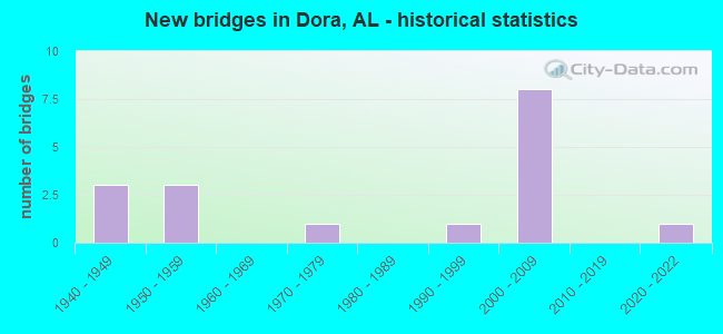
- New bridges - historical statistics
- 31940-1949
- 31950-1959
- 11970-1979
- 11990-1999
- 82000-2009
- 12020-2022


- Bridge Condition - Deck
- 15.4%Very good
- 38.5%Good
- 23.1%Satisfactory
- 23.1%Fair

- Bridge Condition - Superstructure
- 7.7%Very good
- 53.8%Good
- 15.4%Satisfactory
- 23.1%Fair

- Bridge Condition - Substructure
- 15.4%Very good
- 46.2%Good
- 30.8%Satisfactory
- 7.7%Fair

- Bridge Condition - Channel
- 33.3%Very good
- 25.0%Good
- 16.7%Satisfactory
- 25.0%Fair

- Bridge Condition - Culverts
- 33.3%Good
- 33.3%Satisfactory
- 33.3%Fair
Find on map >> Show street view
Structure Number: 2227, Location: 1 MILE S DORA (Lat: 33.716667, Lng: -87.083333), Route carried "on" structure: County highway , Year Built: 1940, Status: Open, Structure Length: 1.68m (5.51ft), Average Daily Traffic: 1,000 (year 1991), Truck Traffic: 20%, Average Future Daily Traffic: 1,400 (year 2032), Features Intersected: BURNT CANE CREEK, Facility Carried by Structure: SHARON BLVD
Minimum Vertical Clearance: 30+ m (98+ ft), Kilometerpoint: 0.010, Lanes on structure: 2, Owner: County Highway Agency, Approaching Roadway Width: 6.1m (20.0ft), Skew: 3 degrees, Material/Design: Concrete continuous, Design/Construction: Slab, Number Of Spans In Main Unit: 3, Length of Maximum Span: 6.1m (20.0ft), Curb-To-Curb Width: 6.1m (20.0ft), Out-to-Out Width: 6.7m (22.0ft)
Condition: Deck: Fair, Superstructure: Fair, Substructure: Satisfactory, Channel: Fair, Operating Rating: 32.7 metric tons, Method Used To Determine Operating Rating: Field evaluation and documented engineering judgment, Inventory Rating: 23.6 metric tons, Method Used To Determine Inventory Rating: Field evaluation and documented engineering judgment, Structural Evaluation: Somewhat better than minimum adequacy, Deck Geometry: High priority of corrective action, Waterway Adequacy: Better than present minimum criteria, Approach Roadway Alignment: Better than present minimum criteria, Length Of Structure Improvement: 2.37m (7.78ft), Designated Inspection Frequency: Every 24 months, Inspection Date: March 2020, Bridge Improvement Cost: $342,000, Roadway Improvement Cost: $34,000, Total Project Cost: $376,000 ( Estimate for 2022), Deck Structure Type: Concrete Cast-file-Place, Wearing Surface/Protective System: Wearing Surface: Bituminous
Find on map >> Show street view
Structure Number: 2228, Location: 2 MILES S DORA (Lat: 33.716667, Lng: -87.083333), Route carried "on" structure: County highway , Year Built: 1940, Status: Open, Structure Length: 2.29m (7.51ft), Average Daily Traffic: 1,000 (year 1991), Truck Traffic: 20%, Average Future Daily Traffic: 1,400 (year 2032), Features Intersected: BURNT CANE CREEK, Facility Carried by Structure: SHARON BLVD
Minimum Vertical Clearance: 30+ m (98+ ft), Kilometerpoint: 0.010, Lanes on structure: 2, Owner: County Highway Agency, Approaching Roadway Width: 6.1m (20.0ft), Material/Design: Concrete continuous, Design/Construction: Slab, Number Of Spans In Main Unit: 4, Length of Maximum Span: 6.0m (19.7ft), Curb-To-Curb Width: 6.1m (20.0ft), Out-to-Out Width: 6.7m (22.0ft)
Condition: Deck: Fair, Superstructure: Fair, Substructure: Satisfactory, Channel: Satisfactory, Operating Rating: 32.7 metric tons, Method Used To Determine Operating Rating: Field evaluation and documented engineering judgment, Inventory Rating: 23.6 metric tons, Method Used To Determine Inventory Rating: Field evaluation and documented engineering judgment, Structural Evaluation: Somewhat better than minimum adequacy, Deck Geometry: High priority of corrective action, Waterway Adequacy: Better than present minimum criteria, Approach Roadway Alignment: Better than present minimum criteria, Length Of Structure Improvement: 3.11m (10.20ft), Designated Inspection Frequency: Every 24 months, Inspection Date: March 2020, Bridge Improvement Cost: $448,000, Roadway Improvement Cost: $45,000, Total Project Cost: $493,000 ( Estimate for 2022), Deck Structure Type: Concrete Cast-file-Place, Wearing Surface/Protective System: Wearing Surface: Bituminous
Find on map >> Show street view
Structure Number: 2229, Location: 1 MILE S DORA (Lat: 33.716667, Lng: -87.083333), Route carried "on" structure: County highway , Year Built: 1940, Status: Open, Structure Length: 1.10m (3.61ft), Average Daily Traffic: 200 (year 1991), Truck Traffic: 1%, Average Future Daily Traffic: 350 (year 2032), Features Intersected: BURNT CANE CREEK, Facility Carried by Structure: BURNWELL RD
Minimum Vertical Clearance: 30+ m (98+ ft), Kilometerpoint: 0.010, Lanes on structure: 2, Owner: County Highway Agency, Approaching Roadway Width: 5.5m (18.0ft), Material/Design: Concrete, Design/Construction: Tee Beam, Number Of Spans In Main Unit: 2, Length of Maximum Span: 5.5m (18.0ft), Curb-To-Curb Width: 6.1m (20.0ft), Out-to-Out Width: 6.7m (22.0ft)
Condition: Deck: Fair, Superstructure: Satisfactory, Substructure: Satisfactory, Channel: Good, Operating Rating: 32.7 metric tons, Method Used To Determine Operating Rating: Field evaluation and documented engineering judgment, Inventory Rating: 23.6 metric tons, Method Used To Determine Inventory Rating: Field evaluation and documented engineering judgment, Structural Evaluation: Equal to present minimum criteria, Deck Geometry: Meets minimum limits, Waterway Adequacy: Better than present minimum criteria, Approach Roadway Alignment: Equal to present minimum criteria, Length Of Structure Improvement: 1.77m (5.81ft), Designated Inspection Frequency: Every 24 months, Inspection Date: March 2020, Bridge Improvement Cost: $267,000, Roadway Improvement Cost: $27,000, Total Project Cost: $294,000 ( Estimate for 2022), Deck Structure Type: Concrete Cast-file-Place, Wearing Surface/Protective System: Wearing Surface: Bituminous
Find on map >> Show street view
Structure Number: 4013, Location: @ Horse Creek Golf Course (Lat: 33.751356, Lng: -87.059011), Route carried "on" structure: State highway 5, Year Built: 1951, Status: Open, Structure Length: 5.79m (19.00ft), Average Daily Traffic: 11,250 (year 2013), Truck Traffic: 18%, Average Future Daily Traffic: 14,085 (year 2041), Design Load: HS 20, Features Intersected: Horse Creek Trail
Minimum Vertical Clearance: 30+ m (98+ ft), Kilometerpoint: 252.519, Lanes on structure: 4, Base Highway Network: Yes, Owner: State Highway Agency, Approaching Roadway Width: 21.9m (71.9ft), Skew: 24 degrees, Material/Design: Concrete, Design/Construction: Tee Beam, Number Of Spans In Main Unit: 5, Length of Maximum Span: 11.6m (38.1ft), Curb-To-Curb Width: 15.2m (49.9ft), Out-to-Out Width: 18.0m (59.1ft)
Condition: Deck: Satisfactory, Superstructure: Fair, Substructure: Satisfactory, Operating Rating: 42.4 metric tons, Method Used To Determine Operating Rating: Load Factor (LF), Inventory Rating: 25.5 metric tons, Method Used To Determine Inventory Rating: Load Factor (LF), Structural Evaluation: Somewhat better than minimum adequacy, Deck Geometry: High priority of corrective action, Underclear: Somewhat better than minimum adequacy, Approach Roadway Alignment: Equal to present minimum criteria, Length Of Structure Improvement: 6.83m (22.41ft), Designated Inspection Frequency: Every 24 months, Inspection Date: April 2021, Bridge Improvement Cost: $2,763,000, Roadway Improvement Cost: $276,000, Total Project Cost: $3,039,000 ( Estimate for 2022), Deck Structure Type: Concrete Cast-file-Place
Find on map >> Show street view
Structure Number: 11045, Location: US 78 @ WALKER CO. LN. (Lat: 33.739600, Lng: -87.030900), Route carried "on" structure: State highway 5, Year Built: 1952, Year Reconstructed: 1974, Status: Open, Structure Length: 1.07m (3.51ft), Average Daily Traffic: 14,660 (year 2020), Truck Traffic: 13%, Average Future Daily Traffic: 18,354 (year 2040), Design Load: H 15, Features Intersected: MORGAN BRANCH
Minimum Vertical Clearance: 30.18m (99.02ft), Kilometerpoint: 248.854, Lanes on structure: 4, Base Highway Network: Yes, Owner: State Highway Agency, Approaching Roadway Width: 26.8m (87.9ft), Skew: 11 degrees, Material/Design: Concrete, Design/Construction: Culvert, Number Of Spans In Main Unit: 3, Length of Maximum Span: 3.0m (9.8ft)
Condition: Channel: Satisfactory, Culverts: Satisfactory, Operating Rating: 88.9 metric tons, Method Used To Determine Operating Rating: Load Factor (LF), Inventory Rating: 55.7 metric tons, Method Used To Determine Inventory Rating: Load Factor (LF), Structural Evaluation: Equal to present minimum criteria, Waterway Adequacy: Better than present minimum criteria, Approach Roadway Alignment: Better than present minimum criteria, Length Of Structure Improvement: 1.74m (5.71ft), Designated Inspection Frequency: Every 24 months, Inspection Date: November 2020, Bridge Improvement Cost: $1,812,000, Roadway Improvement Cost: $181,000, Total Project Cost: $1,993,000 ( Estimate for 2022), Wearing Surface/Protective System: Wearing Surface: Bituminous
Find on map >> Show street view
Structure Number: 11812, Location: WEST BRYAN ROAD (Lat: 33.730861, Lng: -87.075083), Route carried "on" structure: Alternate City street 29, Year Built: 1977, Status: Open, Structure Length: 0.79m (2.59ft), Average Daily Traffic: 500 (year 2010), Truck Traffic: 1%, Average Future Daily Traffic: 700 (year 2041), Features Intersected: BURNT CANE CREEK, Facility Carried by Structure: SELLERS ROAD
Minimum Vertical Clearance: 30+ m (98+ ft), Kilometerpoint: 0.249, Lanes on structure: 2, Owner: City or Municipal Highway Agency, Approaching Roadway Width: 5.6m (18.4ft), Material/Design: Steel, Design/Construction: Stringer/Multi-beam, Number Of Spans In Main Unit: 1, Length of Maximum Span: 7.9m (25.9ft), Curb-To-Curb Width: 6.2m (20.3ft), Out-to-Out Width: 6.2m (20.3ft)
Condition: Deck: Satisfactory, Superstructure: Satisfactory, Substructure: Fair, Channel: Fair, Operating Rating: 67.9 metric tons, Method Used To Determine Operating Rating: Load Factor (LF), Inventory Rating: 40.6 metric tons, Method Used To Determine Inventory Rating: Load Factor (LF), Structural Evaluation: Somewhat better than minimum adequacy, Deck Geometry: High priority of corrective action, Waterway Adequacy: Somewhat better than minimum adequacy, Approach Roadway Alignment: Somewhat better than minimum adequacy, Length Of Structure Improvement: 1.45m (4.76ft), Designated Inspection Frequency: Every 24 months, Inspection Date: December 2021, Bridge Improvement Cost: $199,000, Roadway Improvement Cost: $20,000, Total Project Cost: $219,000 ( Estimate for 2022), Deck Structure Type: Concrete Cast-file-Place
Find on map >> Show street view
Structure Number: 16219, Location: JCT. REID RD. (Lat: 33.728944, Lng: -87.065917), Route carried "on" structure: City street , Year Built: 1992, Status: Open, Structure Length: 1.04m (3.41ft), Average Daily Traffic: 500 (year 2010), Truck Traffic: 1%, Average Future Daily Traffic: 700 (year 2041), Design Load: H 15, Features Intersected: BURNT CANE CREEK, Facility Carried by Structure: SELLERS ROAD
Minimum Vertical Clearance: 30+ m (98+ ft), Kilometerpoint: 0.750, Lanes on structure: 2, Owner: City or Municipal Highway Agency, Approaching Roadway Width: 6.6m (21.7ft), Material/Design: Concrete, Design/Construction: Channel Beam, Number Of Spans In Main Unit: 1, Length of Maximum Span: 10.4m (34.1ft), Curb-To-Curb Width: 7.5m (24.6ft), Out-to-Out Width: 8.2m (26.9ft)
Condition: Deck: Good, Superstructure: Good, Substructure: Good, Channel: Good, Operating Rating: 75.2 metric tons, Method Used To Determine Operating Rating: Load Factor (LF), Inventory Rating: 45.2 metric tons, Method Used To Determine Inventory Rating: Load Factor (LF), Structural Evaluation: Better than present minimum criteria, Deck Geometry: Meets minimum limits, Waterway Adequacy: Equal to present desirable criteria, Approach Roadway Alignment: Equal to present minimum criteria, Length Of Structure Improvement: 1.71m (5.61ft), Designated Inspection Frequency: Every 24 months, Inspection Date: December 2021, Bridge Improvement Cost: $316,000, Roadway Improvement Cost: $32,000, Total Project Cost: $348,000 ( Estimate for 2022), Deck Structure Type: Concrete Precast Panels
Find on map >> Show street view
Structure Number: 17421, Location: 1MI W OF CR-81 (Lat: 33.685406, Lng: -87.103778), Route carried "on" structure: Interstate 22, Year Built: 2004, Status: Open, Structure Length: 16.46m (54.00ft), Average Daily Traffic: 9,140 (year 2013), Truck Traffic: 22%, Average Future Daily Traffic: 12,383 (year 2041), Design Load: HS 20, Features Intersected: Burnt Caine Creek
Minimum Vertical Clearance: 30+ m (98+ ft), Kilometerpoint: 124.483, Lanes on structure: 3, Base Highway Network: Yes, Owner: State Highway Agency, Approaching Roadway Width: 17.1m (56.1ft), Material/Design: Prestressed concrete, Design/Construction: Stringer/Multi-beam, Number Of Spans In Main Unit: 4, Length of Maximum Span: 41.1m (134.8ft), Curb-To-Curb Width: 17.1m (56.1ft), Out-to-Out Width: 17.9m (58.7ft)
Condition: Deck: Good, Superstructure: Good, Substructure: Good, Channel: Very good, Operating Rating: 75.4 metric tons, Method Used To Determine Operating Rating: Load Factor (LF), Inventory Rating: 42.5 metric tons, Method Used To Determine Inventory Rating: Load Factor (LF), Structural Evaluation: Better than present minimum criteria, Deck Geometry: Equal to present minimum criteria, Waterway Adequacy: Superior to present desirable criteria, Approach Roadway Alignment: Superior to present desirable criteria, Length Of Structure Improvement: 17.20m (56.43ft), Designated Inspection Frequency: Every 24 months, Inspection Date: January 2021, Bridge Improvement Cost: $6,840,000, Roadway Improvement Cost: $684,000, Total Project Cost: $7,524,000 ( Estimate for 2022), Deck Structure Type: Concrete Cast-file-Place
Find on map >> Show street view
Structure Number: 17422, Location: 1MI West of CR- 81 (Lat: 33.685769, Lng: -87.103633), Route carried "on" structure: Interstate 22, Year Built: 2004, Status: Open, Structure Length: 16.46m (54.00ft), Average Daily Traffic: 9,140 (year 2020), Truck Traffic: 22%, Average Future Daily Traffic: 12,383 (year 2041), Design Load: HS 20, Features Intersected: Burnt Caine Creek
Minimum Vertical Clearance: 30+ m (98+ ft), Kilometerpoint: 124.483, Lanes on structure: 3, Base Highway Network: Yes, Owner: State Highway Agency, Approaching Roadway Width: 17.1m (56.1ft), Material/Design: Prestressed concrete, Design/Construction: Stringer/Multi-beam, Number Of Spans In Main Unit: 4, Length of Maximum Span: 41.1m (134.8ft), Curb-To-Curb Width: 17.1m (56.1ft), Out-to-Out Width: 17.9m (58.7ft)
Condition: Deck: Good, Superstructure: Good, Substructure: Good, Channel: Very good, Operating Rating: 75.4 metric tons, Method Used To Determine Operating Rating: Load Factor (LF), Inventory Rating: 42.5 metric tons, Method Used To Determine Inventory Rating: Load Factor (LF), Structural Evaluation: Better than present minimum criteria, Deck Geometry: Equal to present minimum criteria, Waterway Adequacy: Superior to present desirable criteria, Approach Roadway Alignment: Superior to present desirable criteria, Length Of Structure Improvement: 17.20m (56.43ft), Designated Inspection Frequency: Every 24 months, Inspection Date: January 2021, Bridge Improvement Cost: $6,840,000, Roadway Improvement Cost: $684,000, Total Project Cost: $7,524,000 ( Estimate for 2022), Deck Structure Type: Concrete Cast-file-Place
Find on map >> Show street view
Structure Number: 17787, Location: River Rd @ I-22 MM 76.2 (Lat: 33.692594, Lng: -87.122828), Route carried "on" structure: County highway , Year Built: 2004, Status: Open, Structure Length: 8.53m (27.99ft), Average Daily Traffic: 500 (year 2005), Average Future Daily Traffic: 750 (year 2041), Design Load: HS 20, Features Intersected: I-22, Facility Carried by Structure: River Road
Minimum Vertical Clearance: 30+ m (98+ ft), Kilometerpoint: 0.100, Lanes on structure: 2, Lanes under structure: 6, Owner: State Highway Agency, Approaching Roadway Width: 10.4m (34.1ft), Material/Design: Prestressed concrete, Design/Construction: Stringer/Multi-beam, Number Of Spans In Main Unit: 2, Length of Maximum Span: 42.7m (140.1ft), Curb-To-Curb Width: 10.4m (34.1ft), Out-to-Out Width: 11.2m (36.7ft)
Condition: Deck: Satisfactory, Superstructure: Good, Substructure: Good, Operating Rating: 88.9 metric tons, Method Used To Determine Operating Rating: Load Factor (LF), Inventory Rating: 43.7 metric tons, Method Used To Determine Inventory Rating: Load Factor (LF), Structural Evaluation: Better than present minimum criteria, Deck Geometry: Equal to present minimum criteria, Underclear: Equal to present minimum criteria, Approach Roadway Alignment: Equal to present desirable criteria, Length Of Structure Improvement: 9.52m (31.23ft), Designated Inspection Frequency: Every 24 months, Inspection Date: June 2021, Bridge Improvement Cost: $2,351,000, Roadway Improvement Cost: $235,000, Total Project Cost: $2,586,000 ( Estimate for 2022), Deck Structure Type: Concrete Cast-file-Place
Find on map >> Show street view
Structure Number: 17788, Location: Barney Beach (Lat: 33.709261, Lng: -87.147222), Route carried "on" structure: Interstate 22, Year Built: 2003, Status: Open, Structure Length: 37.80m (124.02ft), Average Daily Traffic: 9,140 (year 2013), Truck Traffic: 22%, Average Future Daily Traffic: 12,383 (year 2041), Design Load: HS 20, Features Intersected: Mulberry Fork Warrior
Minimum Vertical Clearance: 30+ m (98+ ft), Kilometerpoint: 119.735, Lanes on structure: 3, Base Highway Network: Yes, Toll: Toll bridge is a segment, Owner: State Highway Agency, Approaching Roadway Width: 17.1m (56.1ft), Navigation Control: Yes ( Vertical Clearance: 21.9m (71.9ft), Horizontal Clearance: 76.2m (250.0ft)), Material/Design: Steel continuous, Design/Construction: Stringer/Multi-beam, Number Of Spans In Main Unit: 3, Number Of Approach Spans: 5, Length of Maximum Span: 83.8m (274.9ft), Curb-To-Curb Width: 17.1m (56.1ft), Out-to-Out Width: 17.9m (58.7ft)
Condition: Deck: Good, Superstructure: Very good, Substructure: Very good, Channel: Very good, Operating Rating: 81.6 metric tons, Method Used To Determine Operating Rating: Load Factor (LF), Inventory Rating: 50.9 metric tons, Method Used To Determine Inventory Rating: Load Factor (LF), Structural Evaluation: Equal to present desirable criteria, Deck Geometry: Equal to present minimum criteria, Waterway Adequacy: Superior to present desirable criteria, Approach Roadway Alignment: Equal to present desirable criteria, Length Of Structure Improvement: 37.80m (124.02ft), Designated Inspection Frequency: Every 24 months, Inspection Date: November 2021, Bridge Improvement Cost: $15,031,000, Roadway Improvement Cost: $1,503,000, Total Project Cost: $16,534,000 ( Estimate for 2022), Deck Structure Type: Concrete Cast-file-Place
Find on map >> Show street view
Structure Number: 17789, Location: Barney Beach (Lat: 33.709133, Lng: -87.145017), Route carried "on" structure: Interstate 22, Year Built: 2005, Status: Open, Structure Length: 37.80m (124.02ft), Average Daily Traffic: 9,140 (year 2013), Truck Traffic: 22%, Average Future Daily Traffic: 12,383 (year 2041), Design Load: HS 20, Features Intersected: Mulberry Fork Warrior
Minimum Vertical Clearance: 30+ m (98+ ft), Kilometerpoint: 119.735, Lanes on structure: 3, Base Highway Network: Yes, Toll: Toll bridge is a segment, Owner: State Highway Agency, Approaching Roadway Width: 17.1m (56.1ft), Navigation Control: Yes ( Vertical Clearance: 21.9m (71.9ft), Horizontal Clearance: 70.1m (230.0ft)), Material/Design: Steel continuous, Design/Construction: Stringer/Multi-beam, Number Of Spans In Main Unit: 3, Number Of Approach Spans: 5, Length of Maximum Span: 83.8m (274.9ft), Curb-To-Curb Width: 17.1m (56.1ft), Out-to-Out Width: 17.9m (58.7ft)
Condition: Deck: Good, Superstructure: Good, Substructure: Very good, Channel: Very good, Operating Rating: 81.6 metric tons, Method Used To Determine Operating Rating: Load Factor (LF), Inventory Rating: 50.9 metric tons, Method Used To Determine Inventory Rating: Load Factor (LF), Structural Evaluation: Better than present minimum criteria, Deck Geometry: Equal to present minimum criteria, Waterway Adequacy: Superior to present desirable criteria, Approach Roadway Alignment: Superior to present desirable criteria, Length Of Structure Improvement: 37.80m (124.02ft), Designated Inspection Frequency: Every 24 months, Inspection Date: November 2021, Bridge Improvement Cost: $15,031,000, Roadway Improvement Cost: $1,503,000, Total Project Cost: $16,534,000 ( Estimate for 2022), Deck Structure Type: Concrete Cast-file-Place
Find on map >> Show street view
Structure Number: 1827, Location: I-22 over CR-81 (Lat: 33.679117, Lng: -87.084011), Route carried "on" structure: Interstate 22, Year Built: 2004, Status: Open, Structure Length: 9.36m (30.71ft), Average Daily Traffic: 25,062 (year 2020), Truck Traffic: 20%, Average Future Daily Traffic: 30,000 (year 2040), Design Load: HS 20, Features Intersected: Dora Flat Creek Rd
Minimum Vertical Clearance: 30+ m (98+ ft), Kilometerpoint: 126.494, Lanes on structure: 3, Lanes under structure: 2, Base Highway Network: Yes, Owner: State Highway Agency, Approaching Roadway Width: 17.1m (56.1ft), Skew: 6 degrees, Material/Design: Prestressed concrete, Design/Construction: Stringer/Multi-beam, Number Of Spans In Main Unit: 3, Length of Maximum Span: 36.3m (119.1ft), Curb-To-Curb Width: 17.1m (56.1ft), Out-to-Out Width: 17.9m (58.7ft)
Condition: Deck: Very good, Superstructure: Good, Substructure: Good, Operating Rating: 72.8 metric tons, Method Used To Determine Operating Rating: Load Factor (LF), Inventory Rating: 45.4 metric tons, Method Used To Determine Inventory Rating: Load Factor (LF), Structural Evaluation: Better than present minimum criteria, Deck Geometry: Equal to present minimum criteria, Underclear: Superior to present desirable criteria, Approach Roadway Alignment: Equal to present desirable criteria, Length Of Structure Improvement: 10.31m (33.83ft), Designated Inspection Frequency: Every 24 months, Inspection Date: January 2021, Bridge Improvement Cost: $4,102,000, Roadway Improvement Cost: $410,000, Total Project Cost: $4,512,000 ( Estimate for 2022), Deck Structure Type: Concrete Cast-file-Place
Find on map >> Show street view
Structure Number: 18274, Location: I-22 over CR-81 (Lat: 33.679419, Lng: -87.083967), Route carried "on" structure: Interstate 22, Year Built: 2004, Status: Open, Structure Length: 9.36m (30.71ft), Average Daily Traffic: 25,062 (year 2020), Truck Traffic: 20%, Average Future Daily Traffic: 30,000 (year 2040), Design Load: HS 20, Features Intersected: CR-81
Minimum Vertical Clearance: 30.18m (99.02ft), Kilometerpoint: 126.494, Lanes on structure: 3, Lanes under structure: 2, Base Highway Network: Yes, Owner: State Highway Agency, Approaching Roadway Width: 17.1m (56.1ft), Skew: 6 degrees, Material/Design: Prestressed concrete, Design/Construction: Stringer/Multi-beam, Number Of Spans In Main Unit: 3, Length of Maximum Span: 36.3m (119.1ft), Curb-To-Curb Width: 17.1m (56.1ft), Out-to-Out Width: 17.9m (58.7ft)
Condition: Deck: Very good, Superstructure: Good, Substructure: Good, Operating Rating: 72.8 metric tons, Method Used To Determine Operating Rating: Load Factor (LF), Inventory Rating: 45.4 metric tons, Method Used To Determine Inventory Rating: Load Factor (LF), Structural Evaluation: Better than present minimum criteria, Deck Geometry: Equal to present minimum criteria, Underclear: Superior to present desirable criteria, Approach Roadway Alignment: Equal to present desirable criteria, Length Of Structure Improvement: 10.31m (33.83ft), Designated Inspection Frequency: Every 24 months, Inspection Date: January 2021, Bridge Improvement Cost: $4,102,000, Roadway Improvement Cost: $410,000, Total Project Cost: $4,512,000 ( Estimate for 2022), Deck Structure Type: Concrete Cast-file-Place
Find on map >> Show street view
Structure Number: 20884, Location: .04MI S OF HORSECREEK BLV (Lat: 33.736864, Lng: -87.098136), Route carried "on" structure: City street , Year Built: 1950, Status: Open, Structure Length: 0.88m (2.89ft), Average Daily Traffic: 500 (year 2014), Average Future Daily Traffic: 500 (year 2041), Design Load: HS 20, Features Intersected: HORSECREEK, Facility Carried by Structure: UNION CAMP RD
Minimum Vertical Clearance: 30+ m (98+ ft), Kilometerpoint: 0.000, Lanes on structure: 2, Owner: City or Municipal Highway Agency, Approaching Roadway Width: 7.6m (24.9ft), Material/Design: Concrete, Design/Construction: Culvert, Number Of Spans In Main Unit: 3, Length of Maximum Span: 2.7m (8.9ft), Curb-To-Curb Width: 7.6m (24.9ft), Out-to-Out Width: 7.6m (24.9ft)
Condition: Channel: Fair, Culverts: Fair, Operating Rating: 52.4 metric tons, Method Used To Determine Operating Rating: Load Factor (LF), Inventory Rating: 31.4 metric tons, Method Used To Determine Inventory Rating: Load Factor (LF), Structural Evaluation: Somewhat better than minimum adequacy, Deck Geometry: Meets minimum limits, Waterway Adequacy: Somewhat better than minimum adequacy, Approach Roadway Alignment: Equal to present minimum criteria, Length Of Structure Improvement: 1.54m (5.05ft), Designated Inspection Frequency: Every 24 months, Other Special Inspection Frequency: Every 12 months, Inspection Date: December 2021, Other Special Inspection Date: December 2021, Bridge Improvement Cost: $214,000, Roadway Improvement Cost: $21,000, Total Project Cost: $235,000 ( Estimate for 2022)
Find on map >> Show street view
Structure Number: 21626, Location: .1 mlies from Horse Creek (Lat: 0.000278, Lng: -0.000278), Route carried "on" structure: City street , Year Built: 2021, Status: Open, Structure Length: 1.65m (5.41ft), Average Daily Traffic: 500 (year 2014), Truck Traffic: 1%, Average Future Daily Traffic: 500 (year 2041), Design Load: HS 20, Features Intersected: Horse Creek, Facility Carried by Structure: Commerce Ave
Minimum Vertical Clearance: 30.18m (99.02ft), Kilometerpoint: 0.000, Lanes on structure: 2, Owner: City or Municipal Highway Agency, Approaching Roadway Width: 7.9m (25.9ft), Material/Design: Aluminum, Iron, Design/Construction: Culvert, Number Of Spans In Main Unit: 2, Length of Maximum Span: 8.2m (26.9ft), Curb-To-Curb Width: 7.9m (25.9ft), Out-to-Out Width: 7.9m (25.9ft)
Condition: Channel: Good, Culverts: Good, Operating Rating: 88.9 metric tons, Method Used To Determine Operating Rating: Load Factor (LF), Inventory Rating: 53.5 metric tons, Method Used To Determine Inventory Rating: Load Factor (LF), Structural Evaluation: Better than present minimum criteria, Deck Geometry: Somewhat better than minimum adequacy, Waterway Adequacy: Better than present minimum criteria, Approach Roadway Alignment: Equal to present desirable criteria, Length Of Structure Improvement: 2.33m (7.64ft), Designated Inspection Frequency: Every 24 months, Inspection Date: December 2021, Bridge Improvement Cost: $351,000, Roadway Improvement Cost: $35,000, Total Project Cost: $386,000 ( Estimate for 2022)
Find on map >> Show street view
Structure Number: 17787, Location: River Rd @ I-22 MM 76.2 (Lat: 33.692594, Lng: -87.122828), Route carried "under" structure: Interstate 22, Year Built: 2004, Structure Length: 0. m, Average Daily Traffic: 9,140 (year 2013), Truck Traffic: 22%, Features Intersected: I-22, Facility Carried by Structure: River Road
Minimum Vertical Clearance: 7.99m (26.21ft), Kilometerpoint: 122.632, Lanes on structure: 2, Lanes under structure: 6, Material/Design: Prestressed concrete, Design/Construction: Stringer/Multi-beam, Length of Maximum Span: 42.7m (140.1ft)