Bridge Statistics for Douglassville, Pennsylvania (PA)
Condition, Traffic, Stress, Structural Evaluation, Project Costs
- National Bridge Inventory (NBI) Statistics
- 13Number of bridges
- 131ft / 40.4mTotal length
- $3,453,000Total costs
- 122,663Total average daily traffic
- 10,168Total average daily truck traffic
- National Bridge Inventory (NBI) Registered Bridges for Douglassville
- No street view available for this location
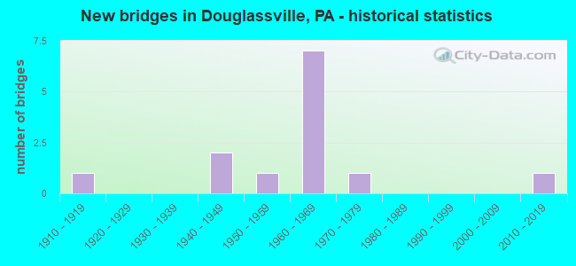
- New bridges - historical statistics
- 11910-1919
- 21940-1949
- 11950-1959
- 71960-1969
- 11970-1979
- 12010-2019
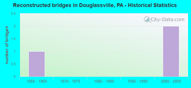
- Reconstructed bridges - Historical Statistics
- 11960-1969
- 01970-1979
- 01980-1989
- 01990-1999
- 22000-2009
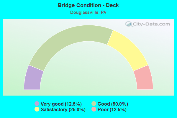
- Bridge Condition - Deck
- 12.5%Very good
- 50.0%Good
- 25.0%Satisfactory
- 12.5%Poor
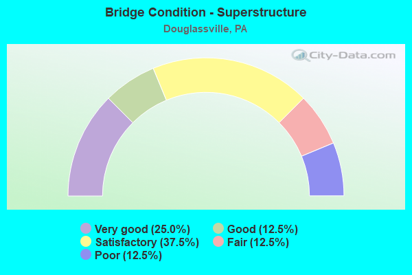
- Bridge Condition - Superstructure
- 25.0%Very good
- 12.5%Good
- 37.5%Satisfactory
- 12.5%Fair
- 12.5%Poor
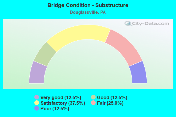
- Bridge Condition - Substructure
- 12.5%Very good
- 12.5%Good
- 37.5%Satisfactory
- 25.0%Fair
- 12.5%Poor
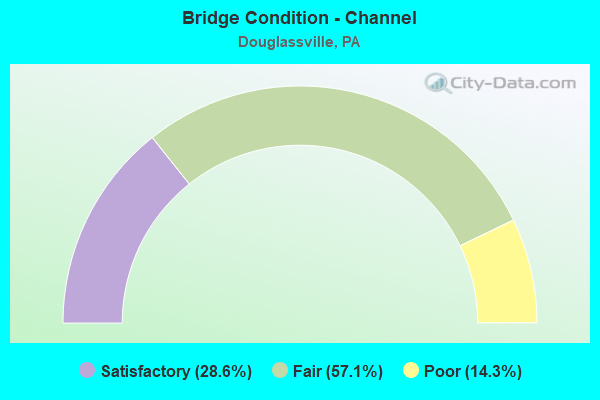
- Bridge Condition - Channel
- 28.6%Satisfactory
- 57.1%Fair
- 14.3%Poor
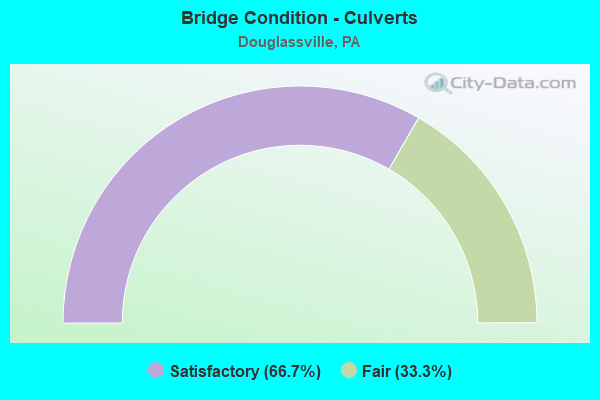
- Bridge Condition - Culverts
- 66.7%Satisfactory
- 33.3%Fair
Find on map >> Show street view
Structure Number: 487, Location: US422EB-OLD 422EB JUNCT. (Lat: 40.254553, Lng: -75.721214), Route carried "on" structure: US 422, Year Built: 1941, Year Reconstructed: 1967, Status: Open, Structure Length: 0.64m (2.10ft), Average Daily Traffic: 300 (year 2020), Truck Traffic: 10%, Average Future Daily Traffic: 23,222 (year 2032), Design Load: HS 20, Features Intersected: LEAFS RUN
Minimum Vertical Clearance: 30+ m (98+ ft), Kilometerpoint: 49.642, Lanes on structure: 2, Base Highway Network: Yes, Owner: State Highway Agency, Approaching Roadway Width: 21.9m (71.9ft), Skew: 14 degrees, Material/Design: Concrete, Design/Construction: Culvert, Number Of Spans In Main Unit: 1, Length of Maximum Span: 6.4m (21.0ft)
Condition: Channel: Fair, Culverts: Satisfactory, Operating Rating: 89.8 metric tons, Method Used To Determine Operating Rating: Load Factor (LF), Inventory Rating: 89.8 metric tons, Method Used To Determine Inventory Rating: Load Factor (LF), Structural Evaluation: Equal to present minimum criteria, Waterway Adequacy: Superior to present desirable criteria, Approach Roadway Alignment: Equal to present desirable criteria, Length Of Structure Improvement: 1.20m (3.94ft), Designated Inspection Frequency: Every 24 months, Inspection Date: Febuary 2020
Find on map >> Show street view
Structure Number: 4871, Location: US 422WB-OLD 422 JUNCT. (Lat: 40.255331, Lng: -75.721292), Route carried "on" structure: US 422, Year Built: 1967, Status: Open, Structure Length: 0.76m (2.49ft), Average Daily Traffic: 16,567 (year 2022), Truck Traffic: 7%, Average Future Daily Traffic: 21,126 (year 2032), Design Load: HS 20, Features Intersected: LEAF'S RUN
Minimum Vertical Clearance: 30+ m (98+ ft), Kilometerpoint: 49.515, Lanes on structure: 2, Base Highway Network: Yes, Owner: State Highway Agency, Approaching Roadway Width: 16.5m (54.1ft), Skew: 13 degrees, Material/Design: Concrete, Design/Construction: Culvert, Number Of Spans In Main Unit: 1, Length of Maximum Span: 7.6m (24.9ft)
Condition: Channel: Fair, Culverts: Satisfactory, Operating Rating: 89.8 metric tons, Method Used To Determine Operating Rating: Load Factor (LF), Inventory Rating: 89.8 metric tons, Method Used To Determine Inventory Rating: Load Factor (LF), Structural Evaluation: Equal to present minimum criteria, Waterway Adequacy: Superior to present desirable criteria, Approach Roadway Alignment: Equal to present desirable criteria, Length Of Structure Improvement: 1.50m (4.92ft), Designated Inspection Frequency: Every 24 months, Inspection Date: Febuary 2020
Find on map >> Show street view
Structure Number: 4872, Location: DOUGLASSVILLE (Lat: 40.254358, Lng: -75.720072), Route carried "on" structure: US 422, Year Built: 1967, Status: Open, Structure Length: 1.80m (5.91ft), Average Daily Traffic: 16,551 (year 2022), Truck Traffic: 9%, Average Future Daily Traffic: 24,208 (year 2032), Design Load: HS 20, Features Intersected: SR 2022 EB(LR 146 PAR.)
Minimum Vertical Clearance: 30+ m (98+ ft), Kilometerpoint: 49.515, Lanes on structure: 2, Lanes under structure: 2, Base Highway Network: Yes, Owner: State Highway Agency, Approaching Roadway Width: 11.6m (38.1ft), Skew: 4 degrees, Material/Design: Prestressed concrete, Design/Construction: Box Beam or Girders - Single/Spread, Number Of Spans In Main Unit: 1, Length of Maximum Span: 17.7m (58.1ft), Curb-To-Curb Width: 11.6m (38.1ft), Out-to-Out Width: 13.9m (45.6ft)
Condition: Deck: Satisfactory, Superstructure: Satisfactory, Substructure: Satisfactory, Operating Rating: 74.4 metric tons, Method Used To Determine Operating Rating: Load Factor (LF), Inventory Rating: 28.1 metric tons, Method Used To Determine Inventory Rating: Load Factor (LF), Structural Evaluation: Equal to present minimum criteria, Deck Geometry: Equal to present minimum criteria, Underclear: Equal to present minimum criteria, Approach Roadway Alignment: Equal to present desirable criteria, Length Of Structure Improvement: 2.50m (8.20ft), Designated Inspection Frequency: Every 24 months, Inspection Date: Febuary 2020, Bridge Improvement Cost: $13,000, Roadway Improvement Cost: $39,000, Total Project Cost: $179,000, Deck Structure Type: Concrete Cast-file-Place, Wearing Surface/Protective System: Wearing Surface: Epoxy Overlay
Find on map >> Show street view
Structure Number: 4873, Location: 1 MI.W.OF MONTGOMERY LINE (Lat: 40.253089, Lng: -75.719406), Route carried "on" structure: US 422, Year Built: 1967, Year Reconstructed: 2011, Status: Open, Structure Length: 8.47m (27.79ft), Average Daily Traffic: 32,428 (year 2022), Truck Traffic: 9%, Average Future Daily Traffic: 47,430 (year 2032), Design Load: HS 20, Features Intersected: NORFOLK SOUTHERN RR
Minimum Vertical Clearance: 0.00m, Kilometerpoint: 50.348, Lanes on structure: 4, Base Highway Network: Yes, Owner: State Highway Agency, Approaching Roadway Width: 21.3m (69.9ft), Skew: 34 degrees, Material/Design: Prestressed concrete, Design/Construction: Box Beam or Girders - Single/Spread, Number Of Spans In Main Unit: 4, Length of Maximum Span: 25.0m (82.0ft), Curb or Sidewalk Widths: Left: 0.5m (1.6ft), Right: 0.5m (1.6ft), Curb-To-Curb Width: 19.5m (64.0ft), Out-to-Out Width: 22.0m (72.2ft)
Condition: Deck: Good, Superstructure: Fair, Substructure: Satisfactory, Operating Rating: 67.1 metric tons, Method Used To Determine Operating Rating: Assigned rating based on Load Factor Design (LFD) reported in metric tons, Inventory Rating: 25.4 metric tons, Method Used To Determine Inventory Rating: Assigned rating based on Load Factor Design (LFD) reported in metric tons, Structural Evaluation: Somewhat better than minimum adequacy, Deck Geometry: Somewhat better than minimum adequacy, Underclear: High priority of corrective action, Approach Roadway Alignment: Equal to present desirable criteria, Length Of Structure Improvement: 9.40m (30.84ft), Designated Inspection Frequency: Every 24 months, Inspection Date: March 2020, Bridge Improvement Cost: $133,000, Roadway Improvement Cost: $390,000, Total Project Cost: $1,790,000, Deck Structure Type: Concrete Cast-file-Place, Wearing Surface/Protective System: Wearing Surface: Latex Concrete
Find on map >> Show street view
Structure Number: 4874, Location: W.OF MONTGOMERY CO LINE (Lat: 40.250472, Lng: -75.717867), Route carried "on" structure: US 422, Year Built: 1967, Status: Open, Structure Length: 1.62m (5.31ft), Average Daily Traffic: 32,428 (year 2022), Truck Traffic: 9%, Average Future Daily Traffic: 47,430 (year 2032), Design Load: HS 20, Features Intersected: OLD PHILADEPHIA PIKE
Minimum Vertical Clearance: 30+ m (98+ ft), Kilometerpoint: 50.854, Lanes on structure: 4, Lanes under structure: 2, Base Highway Network: Yes, Owner: State Highway Agency, Approaching Roadway Width: 24.1m (79.1ft), Skew: 34 degrees, Material/Design: Prestressed concrete, Design/Construction: Box Beam or Girders - Single/Spread, Number Of Spans In Main Unit: 1, Length of Maximum Span: 15.5m (50.9ft), Curb-To-Curb Width: 24.1m (79.1ft), Out-to-Out Width: 26.5m (86.9ft)
Condition: Deck: Satisfactory, Superstructure: Satisfactory, Substructure: Fair, Operating Rating: 53.5 metric tons, Method Used To Determine Operating Rating: Assigned rating based on Load Factor Design (LFD) reported in metric tons, Inventory Rating: 28.1 metric tons, Method Used To Determine Inventory Rating: Assigned rating based on Load Factor Design (LFD) reported in metric tons, Structural Evaluation: Somewhat better than minimum adequacy, Deck Geometry: Superior to present desirable criteria, Underclear: Meets minimum limits, Approach Roadway Alignment: Equal to present desirable criteria, Length Of Structure Improvement: 2.30m (7.55ft), Designated Inspection Frequency: Every 24 months, Inspection Date: January 2021, Bridge Improvement Cost: $25,000, Roadway Improvement Cost: $73,000, Total Project Cost: $334,000, Deck Structure Type: Concrete Cast-file-Place, Wearing Surface/Protective System: Wearing Surface: Latex Concrete
Find on map >> Show street view
Structure Number: 4918, Location: 1.3M.W OF CHESTER CO LINE (Lat: 40.248122, Lng: -75.721122), Route carried "on" structure: State highway 724, Year Built: 1949, Status: Open, Structure Length: 0.64m (2.10ft), Average Daily Traffic: 7,757 (year 2022), Truck Traffic: 9%, Average Future Daily Traffic: 7,674 (year 2032), Design Load: HS 20, Features Intersected: TRIB SCHUYLKILL RIV
Minimum Vertical Clearance: 30+ m (98+ ft), Kilometerpoint: 26.985, Lanes on structure: 2, Owner: State Highway Agency, Approaching Roadway Width: 9.1m (29.9ft), Material/Design: Concrete, Design/Construction: Culvert, Number Of Spans In Main Unit: 1, Length of Maximum Span: 6.4m (21.0ft)
Condition: Channel: Poor, Culverts: Fair, Operating Rating: 89.8 metric tons, Method Used To Determine Operating Rating: Allowable Stress (AS), Inventory Rating: 89.8 metric tons, Method Used To Determine Inventory Rating: Allowable Stress (AS), Structural Evaluation: Somewhat better than minimum adequacy, Waterway Adequacy: Equal to present minimum criteria, Approach Roadway Alignment: Equal to present desirable criteria, Length Of Structure Improvement: 1.20m (3.94ft), Designated Inspection Frequency: Every 24 months, Underwater Inspection Frequency: Every 24 months, Inspection Date: June 2021, Underwater Inspection Date: September 2021
Find on map >> Show street view
Structure Number: 5122, Location: TOWNSHIPLINE&TOLLGATE RDS (Lat: 40.263211, Lng: -75.715997), Route carried "on" structure: State highway , Year Built: 1914, Status: Open, Structure Length: 0.70m (2.30ft), Average Daily Traffic: 393 (year 2022), Truck Traffic: 4%, Average Future Daily Traffic: 858 (year 2032), Design Load: HS 20, Features Intersected: LEAF CREEK, Facility Carried by Structure: SR 2057(LR 06204)
Minimum Vertical Clearance: 30+ m (98+ ft), Kilometerpoint: 0.000, Lanes on structure: 2, Owner: State Highway Agency, Approaching Roadway Width: 5.5m (18.0ft), Material/Design: Concrete, Design/Construction: Slab, Number Of Spans In Main Unit: 1, Length of Maximum Span: 6.4m (21.0ft), Curb-To-Curb Width: 5.5m (18.0ft), Out-to-Out Width: 6.2m (20.3ft)
Condition: Deck: Poor, Superstructure: Poor, Substructure: Poor, Channel: Satisfactory, Operating Rating: 57.2 metric tons, Method Used To Determine Operating Rating: Field evaluation and documented engineering judgment, Inventory Rating: 34.5 metric tons, Method Used To Determine Inventory Rating: Field evaluation and documented engineering judgment, Structural Evaluation: Meets minimum limits, Deck Geometry: High priority of corrective action, Waterway Adequacy: Better than present minimum criteria, Approach Roadway Alignment: Equal to present desirable criteria, Length Of Structure Improvement: 1.30m (4.27ft), Designated Inspection Frequency: Every 24 months, Inspection Date: April 2020, Bridge Improvement Cost: $5,000, Roadway Improvement Cost: $15,000, Total Project Cost: $70,000, Wearing Surface/Protective System: Wearing Surface: Bituminous
Find on map >> Show street view
Structure Number: 5132, Location: DOUGLASSVILLE BRIDGE (Lat: 40.249194, Lng: -75.725614), Route carried "on" structure: Spur State highway , Year Built: 1951, Year Reconstructed: 2014, Status: Open, Structure Length: 18.71m (61.38ft), Average Daily Traffic: 4,266 (year 2021), Truck Traffic: 5%, Average Future Daily Traffic: 6,111 (year 2032), Design Load: HL 93, Features Intersected: SCHUYLKILL RIVER, Facility Carried by Structure: SR 2077(147 SP)
Minimum Vertical Clearance: 30+ m (98+ ft), Kilometerpoint: 0.000, Lanes on structure: 2, Owner: State Highway Agency, Approaching Roadway Width: 9.8m (32.2ft), Material/Design: Steel continuous, Design/Construction: Stringer/Multi-beam, Number Of Spans In Main Unit: 6, Length of Maximum Span: 33.2m (108.9ft), Curb-To-Curb Width: 9.8m (32.2ft), Out-to-Out Width: 10.8m (35.4ft)
Condition: Deck: Good, Superstructure: Very good, Substructure: Satisfactory, Channel: Fair, Operating Rating: 47.6 metric tons, Method Used To Determine Operating Rating: Assigned ratings based on Load and Resistance Factor Design (LRFD) reported by rating factor (RF) using HL93 loadings, Inventory Rating: 36.6 metric tons, Method Used To Determine Inventory Rating: Assigned ratings based on Load and Resistance Factor Design (LRFD) reported by rating factor (RF) using HL93 loadings, Structural Evaluation: Equal to present minimum criteria, Deck Geometry: Meets minimum limits, Waterway Adequacy: Superior to present desirable criteria, Approach Roadway Alignment: Better than present minimum criteria, Length Of Structure Improvement: 19.40m (63.65ft), Designated Inspection Frequency: Every 48 months, Underwater Inspection Frequency: Every 60 months, Inspection Date: January 2019, Underwater Inspection Date: October 2020, Bridge Improvement Cost: $80,000, Roadway Improvement Cost: $236,000, Total Project Cost: $1,080,000, Deck Structure Type: Concrete Cast-file-Place, Wearing Surface/Protective System: Wearing Surface: Monolithic Concrete, Deck Protection: Epoxy Coated Reinforcing
Find on map >> Show street view
Structure Number: 5316, Location: LEAF CREEK BRIDGE (Lat: 40.249667, Lng: -75.724864), Route carried "on" structure: Other road 110, Year Built: 1971, Status: Posted for load, Structure Length: 1.31m (4.30ft), Average Daily Traffic: 1,149 (year 2019), Truck Traffic: 3%, Average Future Daily Traffic: 1,161 (year 2024), Design Load: HS 20, Features Intersected: LEAF CREEK, Facility Carried by Structure: OLD PHILY PIKE
Minimum Vertical Clearance: 30+ m (98+ ft), Kilometerpoint: 0.000, Lanes on structure: 2, Owner: County Highway Agency, Approaching Roadway Width: 8.2m (26.9ft), Material/Design: Prestressed concrete, Design/Construction: Box Beam or Girders - Single/Spread, Number Of Spans In Main Unit: 1, Length of Maximum Span: 12.5m (41.0ft), Curb or Sidewalk Widths: Left: 1.5m (4.9ft), Right: 1.5m (4.9ft), Curb-To-Curb Width: 8.5m (27.9ft), Out-to-Out Width: 12.3m (40.4ft)
Condition: Deck: Good, Superstructure: Satisfactory, Substructure: Good, Channel: Satisfactory, Operating Rating: 35.4 metric tons, Method Used To Determine Operating Rating: Load Factor (LF), Inventory Rating: 20.9 metric tons, Method Used To Determine Inventory Rating: Load Factor (LF), Structural Evaluation: Somewhat better than minimum adequacy, Deck Geometry: Somewhat better than minimum adequacy, Waterway Adequacy: Superior to present desirable criteria, Approach Roadway Alignment: Equal to present desirable criteria, Bridge Posting: Required (Relationship of Operating Rating to Maximum Legal Load: 10.0 - 19.9% below), Length Of Structure Improvement: 2.00m (6.56ft), Designated Inspection Frequency: Every 24 months, Other Special Inspection Frequency: Every 12 months, Inspection Date: August 2021, Other Special Inspection Date: August 2021, Deck Structure Type: Concrete Cast-file-Place, Wearing Surface/Protective System: Wearing Surface: Bituminous
Find on map >> Show street view
Structure Number: 547, Location: NEAR CHESTER COUNTY (Lat: 40.239450, Lng: -75.713672), Route carried "on" structure: City street , Year Built: 1966, Status: Open, Structure Length: 0.73m (2.40ft), Average Daily Traffic: 500 (year 2009), Truck Traffic: 1%, Average Future Daily Traffic: 700 (year 2019), Design Load: HS 20, Features Intersected: NORRIS CREEK, Facility Carried by Structure: UNIONVILLE ROAD
Minimum Vertical Clearance: 30+ m (98+ ft), Kilometerpoint: 0.000, Lanes on structure: 2, Owner: Town or Township Highway Agency, Approaching Roadway Width: 5.8m (19.0ft), Skew: 3 degrees, Material/Design: Concrete, Design/Construction: Slab, Number Of Spans In Main Unit: 1, Length of Maximum Span: 6.7m (22.0ft), Curb or Sidewalk Widths: Left: 0.4m (1.3ft), Right: 0.4m (1.3ft), Curb-To-Curb Width: 9.8m (32.2ft), Out-to-Out Width: 11.6m (38.1ft)
Condition: Deck: Good, Superstructure: Good, Substructure: Fair, Channel: Fair, Operating Rating: 68.0 metric tons, Method Used To Determine Operating Rating: Load Factor (LF), Inventory Rating: 40.8 metric tons, Method Used To Determine Inventory Rating: Load Factor (LF), Structural Evaluation: Somewhat better than minimum adequacy, Deck Geometry: Equal to present minimum criteria, Waterway Adequacy: Meets minimum limits, Approach Roadway Alignment: Equal to present desirable criteria, Length Of Structure Improvement: 1.40m (4.59ft), Designated Inspection Frequency: Every 24 months, Inspection Date: August 2021, Deck Structure Type: Concrete Cast-file-Place, Wearing Surface/Protective System: Wearing Surface: Monolithic Concrete
Find on map >> Show street view
Structure Number: 48312, Location: DOUGLASSVILLE (Lat: 40.254292, Lng: -75.724175), Route carried "on" structure: Spur State highway , Year Built: 2013, Status: Open, Structure Length: 5.00m (16.40ft), Average Daily Traffic: 4,266 (year 2021), Truck Traffic: 5%, Average Future Daily Traffic: 6,111 (year 2032), Design Load: HL 93, Features Intersected: NORFOLK SOUTHERN RR, Facility Carried by Structure: SR2077 (LR147SP)
Minimum Vertical Clearance: 30+ m (98+ ft), Kilometerpoint: 0.000, Lanes on structure: 2, Owner: State Highway Agency, Approaching Roadway Width: 8.5m (27.9ft), Skew: 3 degrees, Material/Design: Prestressed concrete, Design/Construction: Box Beam or Girders - Single/Spread, Number Of Spans In Main Unit: 2, Length of Maximum Span: 25.0m (82.0ft), Curb or Sidewalk Widths: Left: 3.9m (12.8ft), Right: 0.2m (0.7ft), Curb-To-Curb Width: 8.5m (27.9ft), Out-to-Out Width: 12.9m (42.3ft)
Condition: Deck: Very good, Superstructure: Very good, Substructure: Very good, Operating Rating: 55.1 metric tons, Method Used To Determine Operating Rating: Assigned ratings based on Load and Resistance Factor Design (LRFD) reported by rating factor (RF) using HL93 loadings, Inventory Rating: 40.2 metric tons, Method Used To Determine Inventory Rating: Assigned ratings based on Load and Resistance Factor Design (LRFD) reported by rating factor (RF) using HL93 loadings, Structural Evaluation: Equal to present desirable criteria, Deck Geometry: Meets minimum limits, Underclear: High priority of corrective action, Approach Roadway Alignment: Equal to present minimum criteria, Designated Inspection Frequency: Every 48 months, Inspection Date: December 2019, Deck Structure Type: Concrete Cast-file-Place, Wearing Surface/Protective System: Wearing Surface: Monolithic Concrete, Deck Protection: Epoxy Coated Reinforcing
Find on map >> Show street view
Structure Number: 4872, Location: DOUGLASSVILLE (Lat: 40.254358, Lng: -75.720072), Route carried "under" structure: State highway , Year Built: 1967, Structure Length: 0. m, Average Daily Traffic: 5,958 (year 2022), Truck Traffic: 8%, Features Intersected: SR 2022 EB(LR 146 PAR.), Facility Carried by Structure: SR 422WB(LR 1041)
Minimum Vertical Clearance: 4.60m (15.09ft), Kilometerpoint: 0.000, Lanes on structure: 2, Lanes under structure: 2, Material/Design: Prestressed concrete, Design/Construction: Box Beam or Girders - Single/Spread, Length of Maximum Span: 17.7m (58.1ft)
Find on map >> Show street view
Structure Number: 4874, Location: W.OF MONTGOMERY CO LINE (Lat: 40.250472, Lng: -75.717867), Route carried "under" structure: City street , Year Built: 1967, Structure Length: 0. m, Average Daily Traffic: 100 (year 1994), Features Intersected: OLD PHILADEPHIA PIKE, Facility Carried by Structure: US 422(LR 1041)
Minimum Vertical Clearance: 4.39m (14.40ft), Kilometerpoint: 0.000, Lanes on structure: 4, Lanes under structure: 2, Material/Design: Prestressed concrete, Design/Construction: Box Beam or Girders - Single/Spread, Length of Maximum Span: 15.5m (50.9ft)