Bridge Statistics for Downingtown, Pennsylvania (PA)
Condition, Traffic, Stress, Structural Evaluation, Project Costs
- National Bridge Inventory (NBI) Statistics
- 44Number of bridges
- 305ft / 93.4mTotal length
- $8,807,000Total costs
- 685,662Total average daily traffic
- 47,599Total average daily truck traffic
- National Bridge Inventory (NBI) Registered Bridges for Downingtown
- No street view available for this location
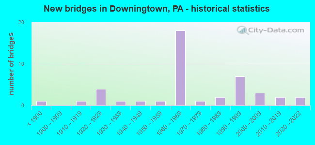
- New bridges - historical statistics
- 1Before 1900
- 11910-1919
- 41920-1929
- 11930-1939
- 11940-1949
- 11950-1959
- 181960-1969
- 11970-1979
- 21980-1989
- 71990-1999
- 32000-2009
- 22010-2019
- 22020-2022
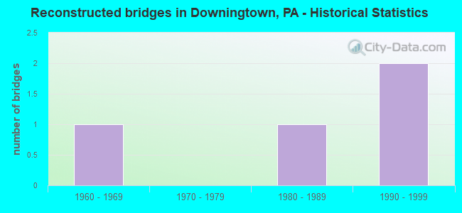
- Reconstructed bridges - Historical Statistics
- 11960-1969
- 01970-1979
- 11980-1989
- 21990-1999
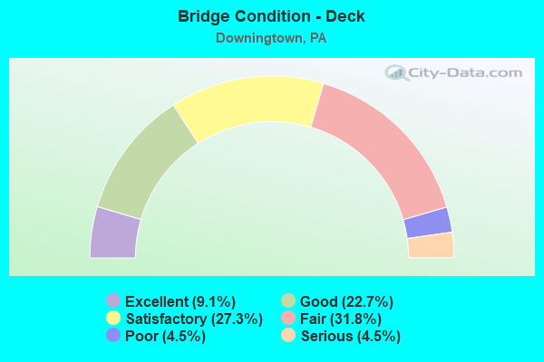
- Bridge Condition - Deck
- 9.1%Excellent
- 22.7%Good
- 27.3%Satisfactory
- 31.8%Fair
- 4.5%Poor
- 4.5%Serious
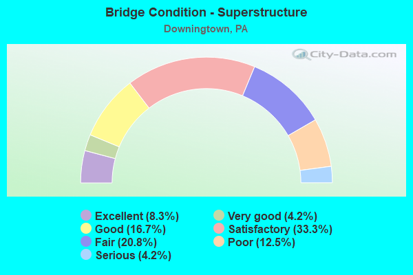
- Bridge Condition - Superstructure
- 8.3%Excellent
- 4.2%Very good
- 16.7%Good
- 33.3%Satisfactory
- 20.8%Fair
- 12.5%Poor
- 4.2%Serious
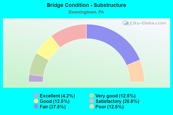
- Bridge Condition - Substructure
- 4.2%Excellent
- 12.5%Very good
- 12.5%Good
- 20.8%Satisfactory
- 37.5%Fair
- 12.5%Poor
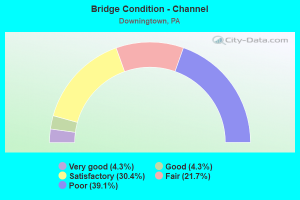
- Bridge Condition - Channel
- 4.3%Very good
- 4.3%Good
- 30.4%Satisfactory
- 21.7%Fair
- 39.1%Poor
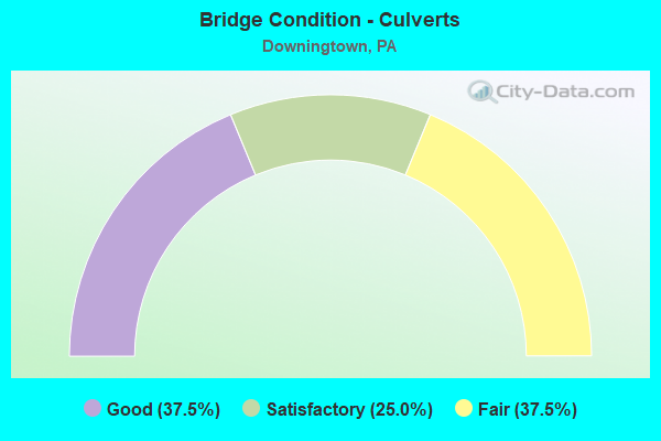
- Bridge Condition - Culverts
- 37.5%Good
- 25.0%Satisfactory
- 37.5%Fair
Find on map >> Show street view
Structure Number: 9974, Location: NEAR DOWNINGTOWN 30D1 (Lat: 40.012575, Lng: -75.725575), Route carried "on" structure: US 30, Year Built: 1961, Status: Open, Structure Length: 5.46m (17.91ft), Average Daily Traffic: 76,991 (year 2022), Truck Traffic: 7%, Average Future Daily Traffic: 91,868 (year 2032), Design Load: HS 20, Features Intersected: US ROUTE 322
Minimum Vertical Clearance: 30+ m (98+ ft), Kilometerpoint: 21.688, Lanes on structure: 6, Lanes under structure: 4, Base Highway Network: Yes, Owner: State Highway Agency, Approaching Roadway Width: 26.8m (87.9ft), Skew: 34 degrees, Material/Design: Steel continuous, Design/Construction: Stringer/Multi-beam, Number Of Spans In Main Unit: 3, Length of Maximum Span: 27.7m (90.9ft), Curb or Sidewalk Widths: Left: 0.5m (1.6ft), Right: 0.5m (1.6ft), Curb-To-Curb Width: 29.6m (97.1ft), Out-to-Out Width: 32.2m (105.6ft)
Condition: Deck: Fair, Superstructure: Satisfactory, Substructure: Satisfactory, Operating Rating: 59.9 metric tons, Method Used To Determine Operating Rating: Load Factor (LF), Inventory Rating: 35.4 metric tons, Method Used To Determine Inventory Rating: Load Factor (LF), Structural Evaluation: Equal to present minimum criteria, Deck Geometry: Superior to present desirable criteria, Underclear: Meets minimum limits, Approach Roadway Alignment: Equal to present desirable criteria, Length Of Structure Improvement: 6.30m (20.67ft), Designated Inspection Frequency: Every 24 months, Inspection Date: June 2021, Bridge Improvement Cost: $178,000, Roadway Improvement Cost: $524,000, Total Project Cost: $2,402,000, Deck Structure Type: Concrete Cast-file-Place, Wearing Surface/Protective System: Wearing Surface: Bituminous
Find on map >> Show street view
Structure Number: 9976, Location: EAST CALN TWP. 20F13 (Lat: 40.017367, Lng: -75.707481), Route carried "on" structure: US 30, Year Built: 1961, Status: Open, Structure Length: 7.16m (23.49ft), Average Daily Traffic: 76,991 (year 2022), Truck Traffic: 7%, Average Future Daily Traffic: 91,868 (year 2032), Design Load: HS 20, Features Intersected: CREEK RD, BRANDYWINE CK.
Minimum Vertical Clearance: 30+ m (98+ ft), Kilometerpoint: 23.360, Lanes on structure: 2, Lanes under structure: 2, Base Highway Network: Yes, Owner: State Highway Agency, Approaching Roadway Width: 20.7m (67.9ft), Skew: 30 degrees, Material/Design: Prestressed concrete, Design/Construction: Box Beam or Girders - Single/Spread, Number Of Spans In Main Unit: 4, Length of Maximum Span: 19.5m (64.0ft), Curb or Sidewalk Widths: Left: 0.5m (1.6ft), Right: 0.5m (1.6ft), Curb-To-Curb Width: 16.5m (54.1ft), Out-to-Out Width: 19.1m (62.7ft)
Condition: Deck: Satisfactory, Superstructure: Satisfactory, Substructure: Poor, Channel: Fair, Operating Rating: 68.9 metric tons, Method Used To Determine Operating Rating: Load Factor (LF), Inventory Rating: 30.8 metric tons, Method Used To Determine Inventory Rating: Load Factor (LF), Structural Evaluation: Meets minimum limits, Deck Geometry: Superior to present desirable criteria, Underclear: Equal to present minimum criteria, Waterway Adequacy: Superior to present desirable criteria, Approach Roadway Alignment: Equal to present desirable criteria, Length Of Structure Improvement: 7.90m (25.92ft), Designated Inspection Frequency: Every 24 months, Inspection Date: June 2021, Bridge Improvement Cost: $173,000, Roadway Improvement Cost: $510,000, Total Project Cost: $2,337,000, Deck Structure Type: Concrete Cast-file-Place, Wearing Surface/Protective System: Wearing Surface: Bituminous
Find on map >> Show street view
Structure Number: 9977, Location: DOWNINGTOWN 20G13 (Lat: 40.018083, Lng: -75.704722), Route carried "on" structure: US 30, Year Built: 1961, Status: Open, Structure Length: 1.13m (3.71ft), Average Daily Traffic: 76,991 (year 2022), Truck Traffic: 7%, Average Future Daily Traffic: 91,868 (year 2032), Design Load: HS 20, Features Intersected: HIKE/BIKE PATH
Minimum Vertical Clearance: 30+ m (98+ ft), Kilometerpoint: 23.360, Lanes on structure: 4, Base Highway Network: Yes, Owner: State Highway Agency, Approaching Roadway Width: 21.9m (71.9ft), Skew: 30 degrees, Material/Design: Prestressed concrete, Design/Construction: Box Beam or Girders - Single/Spread, Number Of Spans In Main Unit: 1, Length of Maximum Span: 11.3m (37.1ft), Curb or Sidewalk Widths: Left: 0.1m (0.3ft), Right: 0.1m (0.3ft), Curb-To-Curb Width: 20.7m (67.9ft), Out-to-Out Width: 23.5m (77.1ft)
Condition: Deck: Fair, Superstructure: Satisfactory, Substructure: Satisfactory, Operating Rating: 57.2 metric tons, Method Used To Determine Operating Rating: Load Factor (LF), Inventory Rating: 33.6 metric tons, Method Used To Determine Inventory Rating: Load Factor (LF), Structural Evaluation: Equal to present minimum criteria, Deck Geometry: Equal to present minimum criteria, Approach Roadway Alignment: Equal to present desirable criteria, Length Of Structure Improvement: 1.70m (5.58ft), Designated Inspection Frequency: Every 24 months, Inspection Date: June 2021, Bridge Improvement Cost: $19,000, Roadway Improvement Cost: $57,000, Total Project Cost: $260,000, Deck Structure Type: Concrete Cast-file-Place, Wearing Surface/Protective System: Wearing Surface: Bituminous
Find on map >> Show street view
Structure Number: 9978, Location: DOWNINGTOWN 20G13 (Lat: 40.018361, Lng: -75.703861), Route carried "on" structure: US 30, Year Built: 1961, Status: Open, Structure Length: 3.05m (10.01ft), Average Daily Traffic: 76,991 (year 2022), Truck Traffic: 7%, Average Future Daily Traffic: 91,868 (year 2032), Design Load: HS 20, Features Intersected: NORWOOD ROAD
Minimum Vertical Clearance: 30+ m (98+ ft), Kilometerpoint: 23.651, Lanes on structure: 4, Lanes under structure: 2, Base Highway Network: Yes, Owner: State Highway Agency, Approaching Roadway Width: 21.9m (71.9ft), Skew: 30 degrees, Material/Design: Prestressed concrete, Design/Construction: Box Beam or Girders - Single/Spread, Number Of Spans In Main Unit: 3, Length of Maximum Span: 12.8m (42.0ft), Curb or Sidewalk Widths: Left: 0.1m (0.3ft), Right: 0.1m (0.3ft), Curb-To-Curb Width: 20.7m (67.9ft), Out-to-Out Width: 21.8m (71.5ft)
Condition: Deck: Fair, Superstructure: Satisfactory, Substructure: Fair, Operating Rating: 56.2 metric tons, Method Used To Determine Operating Rating: Load Factor (LF), Inventory Rating: 31.8 metric tons, Method Used To Determine Inventory Rating: Load Factor (LF), Structural Evaluation: Somewhat better than minimum adequacy, Deck Geometry: Equal to present minimum criteria, Underclear: Somewhat better than minimum adequacy, Approach Roadway Alignment: Equal to present desirable criteria, Length Of Structure Improvement: 3.80m (12.47ft), Designated Inspection Frequency: Every 24 months, Inspection Date: August 2021, Bridge Improvement Cost: $68,000, Roadway Improvement Cost: $200,000, Total Project Cost: $918,000, Deck Structure Type: Concrete Cast-file-Place, Wearing Surface/Protective System: Wearing Surface: Bituminous
Find on map >> Show street view
Structure Number: 9979, Location: NEAR DOWNINGTOWN 21A12 (Lat: 40.019619, Lng: -75.677889), Route carried "on" structure: US 30, Year Built: 1961, Year Reconstructed: 1995, Status: Open, Structure Length: 1.25m (4.10ft), Average Daily Traffic: 62,365 (year 2022), Truck Traffic: 8%, Average Future Daily Traffic: 65,927 (year 2032), Design Load: HS 20, Features Intersected: BELL TAVERN ROAD
Minimum Vertical Clearance: 30+ m (98+ ft), Kilometerpoint: 25.910, Lanes on structure: 5, Lanes under structure: 2, Base Highway Network: Yes, Owner: State Highway Agency, Approaching Roadway Width: 32.0m (105.0ft), Skew: 33 degrees, Material/Design: Prestressed concrete, Design/Construction: Box Beam or Girders - Single/Spread, Number Of Spans In Main Unit: 1, Length of Maximum Span: 12.2m (40.0ft), Curb or Sidewalk Widths: Left: 0.2m (0.7ft), Right: 0.2m (0.7ft), Curb-To-Curb Width: 30.9m (101.4ft), Out-to-Out Width: 33.1m (108.6ft)
Condition: Deck: Good, Superstructure: Good, Substructure: Satisfactory, Operating Rating: 41.7 metric tons, Method Used To Determine Operating Rating: Load Factor (LF), Inventory Rating: 25.4 metric tons, Method Used To Determine Inventory Rating: Load Factor (LF), Structural Evaluation: Equal to present minimum criteria, Deck Geometry: Superior to present desirable criteria, Underclear: High priority of corrective action, Approach Roadway Alignment: Equal to present desirable criteria, Length Of Structure Improvement: 1.90m (6.23ft), Designated Inspection Frequency: Every 24 months, Inspection Date: June 2021, Deck Structure Type: Concrete Cast-file-Place, Wearing Surface/Protective System: Wearing Surface: Monolithic Concrete, Deck Protection: Epoxy Coated Reinforcing
Find on map >> Show street view
Structure Number: 9982, Location: E.DOWNINGTOWN 21A13 (Lat: 40.019144, Lng: -75.675078), Route carried "on" structure: Bypass US 30, Year Built: 1995, Status: Open, Structure Length: 8.75m (28.71ft), Average Daily Traffic: 19,841 (year 2020), Truck Traffic: 11%, Average Future Daily Traffic: 33,386 (year 2032), Design Load: HS 25 or greater, Features Intersected: RTE US 30 BUSINESS, Facility Carried by Structure: EXTON BYPASS(WB)
Minimum Vertical Clearance: 30+ m (98+ ft), Kilometerpoint: 26.033, Lanes on structure: 2, Lanes under structure: 4, Base Highway Network: Yes, Owner: State Highway Agency, Approaching Roadway Width: 13.4m (44.0ft), Skew: 15 degrees, Material/Design: Prestressed concrete continuous, Design/Construction: Stringer/Multi-beam, Number Of Spans In Main Unit: 3, Length of Maximum Span: 41.8m (137.1ft), Curb or Sidewalk Widths: Left: 0.2m (0.7ft), Right: 0.2m (0.7ft), Curb-To-Curb Width: 13.4m (44.0ft), Out-to-Out Width: 14.7m (48.2ft)
Condition: Deck: Good, Superstructure: Satisfactory, Substructure: Satisfactory, Operating Rating: 87.1 metric tons, Method Used To Determine Operating Rating: Load Factor (LF), Inventory Rating: 21.8 metric tons, Method Used To Determine Inventory Rating: Load Factor (LF), Structural Evaluation: Somewhat better than minimum adequacy, Deck Geometry: Superior to present desirable criteria, Underclear: High priority of corrective action, Approach Roadway Alignment: Equal to present desirable criteria, Length Of Structure Improvement: 9.70m (31.82ft), Designated Inspection Frequency: Every 24 months, Inspection Date: June 2020, Deck Structure Type: Concrete Cast-file-Place, Wearing Surface/Protective System: Wearing Surface: Monolithic Concrete, Deck Protection: Epoxy Coated Reinforcing
Find on map >> Show street view
Structure Number: 10075, Location: ROUTE 113 INTER. 20H12 (Lat: 40.019706, Lng: -75.694011), Route carried "on" structure: State highway 113, Year Built: 1961, Year Reconstructed: 1993, Status: Open, Structure Length: 3.05m (10.01ft), Average Daily Traffic: 17,832 (year 2021), Truck Traffic: 7%, Average Future Daily Traffic: 25,309 (year 2032), Design Load: HS 20, Features Intersected: US-30 BYPASS, Facility Carried by Structure: UWCHLAN AVENUE
Minimum Vertical Clearance: 30+ m (98+ ft), Kilometerpoint: 0.885, Lanes on structure: 4, Lanes under structure: 5, Owner: State Highway Agency, Approaching Roadway Width: 14.6m (47.9ft), Skew: 2 degrees, Material/Design: Prestressed concrete, Design/Construction: Stringer/Multi-beam, Number Of Spans In Main Unit: 1, Length of Maximum Span: 29.3m (96.1ft), Curb or Sidewalk Widths: Left: 0.2m (0.7ft), Right: 0.2m (0.7ft), Curb-To-Curb Width: 15.7m (51.5ft), Out-to-Out Width: 17.1m (56.1ft)
Condition: Deck: Fair, Superstructure: Fair, Substructure: Fair, Operating Rating: 67.1 metric tons, Method Used To Determine Operating Rating: Load Factor (LF), Inventory Rating: 22.7 metric tons, Method Used To Determine Inventory Rating: Load Factor (LF), Structural Evaluation: Somewhat better than minimum adequacy, Deck Geometry: Meets minimum limits, Underclear: High priority of corrective action, Approach Roadway Alignment: Better than present minimum criteria, Length Of Structure Improvement: 3.80m (12.47ft), Designated Inspection Frequency: Every 24 months, Inspection Date: October 2019, Bridge Improvement Cost: $42,000, Roadway Improvement Cost: $123,000, Total Project Cost: $565,000, Deck Structure Type: Concrete Cast-file-Place, Wearing Surface/Protective System: Wearing Surface: Bituminous, Membrane: Other
Find on map >> Show street view
Structure Number: 10172, Location: 2 MI.S. 30 BYPASS 20G13 (Lat: 40.014483, Lng: -75.704664), Route carried "on" structure: State highway 282, Year Built: 1974, Status: Open, Structure Length: 5.09m (16.70ft), Average Daily Traffic: 7,619 (year 2022), Truck Traffic: 5%, Average Future Daily Traffic: 6,717 (year 2032), Design Load: HS 20, Features Intersected: E.BR. BRANDYWINE CREEK, Facility Carried by Structure: CREEK ROAD
Minimum Vertical Clearance: 30+ m (98+ ft), Kilometerpoint: 17.516, Lanes on structure: 2, Owner: State Highway Agency, Approaching Roadway Width: 6.7m (22.0ft), Skew: 2 degrees, Material/Design: Prestressed concrete, Design/Construction: Box Beam or Girders - Multiple, Number Of Spans In Main Unit: 2, Length of Maximum Span: 25.3m (83.0ft), Curb-To-Curb Width: 14.6m (47.9ft), Out-to-Out Width: 15.8m (51.8ft)
Condition: Deck: Satisfactory, Superstructure: Satisfactory, Substructure: Satisfactory, Channel: Satisfactory, Operating Rating: 87.1 metric tons, Method Used To Determine Operating Rating: Load Factor (LF), Inventory Rating: 32.7 metric tons, Method Used To Determine Inventory Rating: Load Factor (LF), Structural Evaluation: Equal to present minimum criteria, Deck Geometry: Superior to present desirable criteria, Waterway Adequacy: Better than present minimum criteria, Approach Roadway Alignment: Equal to present desirable criteria, Length Of Structure Improvement: 6.10m (20.01ft), Designated Inspection Frequency: Every 24 months, Inspection Date: June 2021, Deck Structure Type: Concrete Cast-file-Place, Wearing Surface/Protective System: Wearing Surface: Monolithic Concrete, Deck Protection: Galvanized Reinforcing
Find on map >> Show street view
Structure Number: 10189, Location: DOWNINGTOWN 30F2 (Lat: 40.007533, Lng: -75.711842), Route carried "on" structure: US 322, Year Built: 1934, Status: Open, Structure Length: 1.95m (6.40ft), Average Daily Traffic: 11,617 (year 2021), Truck Traffic: 4%, Average Future Daily Traffic: 13,361 (year 2032), Design Load: HS 20, Features Intersected: BEAVER CREEK, Facility Carried by Structure: MANOR AVENUE
Minimum Vertical Clearance: 30+ m (98+ ft), Kilometerpoint: 22.880, Lanes on structure: 2, Base Highway Network: Yes, Owner: State Highway Agency, Approaching Roadway Width: 11.3m (37.1ft), Material/Design: Concrete, Design/Construction: Tee Beam, Number Of Spans In Main Unit: 2, Length of Maximum Span: 9.4m (30.8ft), Curb or Sidewalk Widths: Left: 2.4m (7.9ft), Right: 2.4m (7.9ft), Curb-To-Curb Width: 11.1m (36.4ft), Out-to-Out Width: 15.8m (51.8ft)
Condition: Deck: Fair, Superstructure: Poor, Substructure: Fair, Channel: Fair, Operating Rating: 53.5 metric tons, Method Used To Determine Operating Rating: Load Factor (LF), Inventory Rating: 31.8 metric tons, Method Used To Determine Inventory Rating: Load Factor (LF), Structural Evaluation: Meets minimum limits, Deck Geometry: Meets minimum limits, Waterway Adequacy: Better than present minimum criteria, Approach Roadway Alignment: Equal to present desirable criteria, Length Of Structure Improvement: 2.60m (8.53ft), Designated Inspection Frequency: Every 24 months, Inspection Date: June 2021, Bridge Improvement Cost: $61,000, Roadway Improvement Cost: $178,000, Total Project Cost: $818,000, Deck Structure Type: Concrete Cast-file-Place, Wearing Surface/Protective System: Wearing Surface: Bituminous
Find on map >> Show street view
Structure Number: 1019, Location: DOWNINGTOWN 30G2 (Lat: 40.005969, Lng: -75.705044), Route carried "on" structure: Business US 322, Year Built: 1921, Status: Posted for load, Structure Length: 5.33m (17.49ft), Average Daily Traffic: 17,722 (year 2022), Truck Traffic: 7%, Average Future Daily Traffic: 19,856 (year 2032), Design Load: H 20, Features Intersected: EAST BR. BRANDYWINE CK., Facility Carried by Structure: LANCASTER AVENUE
Minimum Vertical Clearance: 30+ m (98+ ft), Kilometerpoint: 23.561, Lanes on structure: 2, Base Highway Network: Yes, Owner: State Highway Agency, Approaching Roadway Width: 11.6m (38.1ft), Material/Design: Concrete, Design/Construction: Arch - Deck, Number Of Spans In Main Unit: 4, Length of Maximum Span: 12.2m (40.0ft), Curb or Sidewalk Widths: Left: 1.5m (4.9ft), Right: 1.5m (4.9ft), Curb-To-Curb Width: 11.6m (38.1ft), Out-to-Out Width: 16.5m (54.1ft)
Condition: Superstructure: Poor, Substructure: Poor, Channel: Poor, Operating Rating: 50.8 metric tons, Method Used To Determine Operating Rating: Field evaluation and documented engineering judgment, Inventory Rating: 30.8 metric tons, Method Used To Determine Inventory Rating: Field evaluation and documented engineering judgment, Structural Evaluation: Meets minimum limits, Deck Geometry: Somewhat better than minimum adequacy, Waterway Adequacy: Equal to present desirable criteria, Approach Roadway Alignment: Equal to present desirable criteria, Length Of Structure Improvement: 5.30m (17.39ft), Designated Inspection Frequency: Every 24 months, Other Special Inspection Frequency: Every 12 months, Inspection Date: July 2021, Other Special Inspection Date: July 2021, Bridge Improvement Cost: $42,000, Roadway Improvement Cost: $122,000, Total Project Cost: $561,000
Find on map >> Show street view
Structure Number: 10194, Location: < 1/2 MI. BOOT RD 30G4 (Lat: 39.996200, Lng: -75.700997), Route carried "on" structure: US 322, Year Built: 1929, Status: Open, Structure Length: 0.85m (2.79ft), Average Daily Traffic: 15,251 (year 2021), Truck Traffic: 4%, Average Future Daily Traffic: 17,485 (year 2032), Design Load: H 20, Features Intersected: MILL-RACE CREEK, Facility Carried by Structure: BRANDYWINE AVENUE
Minimum Vertical Clearance: 30+ m (98+ ft), Kilometerpoint: 25.062, Lanes on structure: 2, Base Highway Network: Yes, Owner: State Highway Agency, Approaching Roadway Width: 12.2m (40.0ft), Skew: 6 degrees, Material/Design: Concrete, Design/Construction: Culvert, Number Of Spans In Main Unit: 1, Length of Maximum Span: 8.5m (27.9ft), Curb-To-Curb Width: 12.2m (40.0ft), Out-to-Out Width: 13.3m (43.6ft)
Condition: Channel: Poor, Culverts: Fair, Operating Rating: 62.6 metric tons, Method Used To Determine Operating Rating: Field evaluation and documented engineering judgment, Inventory Rating: 30.8 metric tons, Method Used To Determine Inventory Rating: Field evaluation and documented engineering judgment, Structural Evaluation: Somewhat better than minimum adequacy, Deck Geometry: Somewhat better than minimum adequacy, Waterway Adequacy: Equal to present minimum criteria, Approach Roadway Alignment: Equal to present desirable criteria, Length Of Structure Improvement: 1.60m (5.25ft), Designated Inspection Frequency: Every 24 months, Underwater Inspection Frequency: Every 24 months, Inspection Date: August 2021, Underwater Inspection Date: October 2020
Find on map >> Show street view
Structure Number: 102, Location: WEST WEST CHESTER 31B09 (Lat: 39.969889, Lng: -75.666278), Route carried "on" structure: US 322, Year Built: 1929, Year Reconstructed: 1972, Status: Open, Structure Length: 2.38m (7.81ft), Average Daily Traffic: 9,423 (year 2020), Truck Traffic: 12%, Average Future Daily Traffic: 19,373 (year 2032), Design Load: HS 20, Features Intersected: VALLEY CREEK, Facility Carried by Structure: DOWNINGTOWN PIKE
Minimum Vertical Clearance: 30+ m (98+ ft), Kilometerpoint: 29.660, Lanes on structure: 2, Base Highway Network: Yes, Owner: State Highway Agency, Approaching Roadway Width: 9.8m (32.2ft), Material/Design: Concrete, Design/Construction: Tee Beam, Number Of Spans In Main Unit: 2, Length of Maximum Span: 11.3m (37.1ft), Curb-To-Curb Width: 9.1m (29.9ft), Out-to-Out Width: 10.4m (34.1ft)
Condition: Deck: Poor, Superstructure: Poor, Substructure: Fair, Channel: Poor, Operating Rating: 58.1 metric tons, Method Used To Determine Operating Rating: Load Factor (LF), Inventory Rating: 34.5 metric tons, Method Used To Determine Inventory Rating: Load Factor (LF), Structural Evaluation: Meets minimum limits, Deck Geometry: High priority of corrective action, Waterway Adequacy: Equal to present minimum criteria, Approach Roadway Alignment: Equal to present desirable criteria, Length Of Structure Improvement: 3.10m (10.17ft), Designated Inspection Frequency: Every 24 months, Inspection Date: August 2020, Bridge Improvement Cost: $14,000, Roadway Improvement Cost: $40,000, Total Project Cost: $184,000, Deck Structure Type: Concrete Cast-file-Place, Wearing Surface/Protective System: Wearing Surface: Bituminous
Find on map >> Show street view
Structure Number: 10398, Location: NEAR DOWNINGTOWN 31B2 (Lat: 40.006211, Lng: -75.671406), Route carried "on" structure: State highway , Year Built: 1964, Status: Posted for load, Structure Length: 4.94m (16.21ft), Average Daily Traffic: 9,188 (year 2021), Truck Traffic: 9%, Average Future Daily Traffic: 15,075 (year 2032), Design Load: HS 20, Features Intersected: AMTRAK, Facility Carried by Structure: BOOT ROAD
Minimum Vertical Clearance: 30+ m (98+ ft), Kilometerpoint: 2.686, Lanes on structure: 2, Owner: State Highway Agency, Approaching Roadway Width: 11.6m (38.1ft), Skew: 3 degrees, Material/Design: Prestressed concrete, Design/Construction: Box Beam or Girders - Multiple, Number Of Spans In Main Unit: 1, Number Of Approach Spans: 2, Length of Maximum Span: 24.4m (80.1ft), Curb or Sidewalk Widths: Left: 0.5m (1.6ft), Right: 0.5m (1.6ft), Curb-To-Curb Width: 8.0m (26.2ft), Out-to-Out Width: 12.8m (42.0ft)
Condition: Deck: Serious, Superstructure: Serious, Substructure: Fair, Operating Rating: 29.9 metric tons, Method Used To Determine Operating Rating: Load Factor (LF), Inventory Rating: 0.9 metric tons, Method Used To Determine Inventory Rating: Load Factor (LF), Structural Evaluation: High priority of corrective action, Deck Geometry: High priority of replacement, Underclear: High priority of corrective action, Approach Roadway Alignment: Equal to present desirable criteria, Bridge Posting: Required (Relationship of Operating Rating to Maximum Legal Load: 20.0 - 29.9% below), Length Of Structure Improvement: 5.90m (19.36ft), Designated Inspection Frequency: Every 24 months, Other Special Inspection Frequency: Every 12 months, Inspection Date: January 2021, Other Special Inspection Date: January 2021, Deck Structure Type: Other, Wearing Surface/Protective System: Wearing Surface: Bituminous
Find on map >> Show street view
Structure Number: 10399, Location: SE DOWNINGTOWN 31B2 (Lat: 40.006556, Lng: -75.665931), Route carried "on" structure: State highway , Year Built: 1964, Status: Open, Structure Length: 1.37m (4.49ft), Average Daily Traffic: 7,349 (year 2021), Truck Traffic: 8%, Average Future Daily Traffic: 12,768 (year 2032), Design Load: HS 20, Features Intersected: VALLEY CREEK, Facility Carried by Structure: BOOT ROAD
Minimum Vertical Clearance: 30+ m (98+ ft), Kilometerpoint: 2.686, Lanes on structure: 2, Owner: State Highway Agency, Approaching Roadway Width: 11.6m (38.1ft), Material/Design: Prestressed concrete, Design/Construction: Box Beam or Girders - Multiple, Number Of Spans In Main Unit: 1, Length of Maximum Span: 13.4m (44.0ft), Curb-To-Curb Width: 11.6m (38.1ft), Out-to-Out Width: 12.8m (42.0ft)
Condition: Deck: Satisfactory, Superstructure: Satisfactory, Substructure: Fair, Channel: Poor, Operating Rating: 45.4 metric tons, Method Used To Determine Operating Rating: Load Factor (LF), Inventory Rating: 21.8 metric tons, Method Used To Determine Inventory Rating: Load Factor (LF), Structural Evaluation: Somewhat better than minimum adequacy, Deck Geometry: Somewhat better than minimum adequacy, Waterway Adequacy: Superior to present desirable criteria, Approach Roadway Alignment: Equal to present desirable criteria, Length Of Structure Improvement: 2.10m (6.89ft), Designated Inspection Frequency: Every 24 months, Underwater Inspection Frequency: Every 24 months, Inspection Date: July 2021, Underwater Inspection Date: September 2021, Deck Structure Type: Concrete Cast-file-Place, Wearing Surface/Protective System: Wearing Surface: Integral Concrete, Membrane: Epoxy, Deck Protection: Epoxy Coated Reinforcing
Find on map >> Show street view
Structure Number: 10531, Location: NEAR GRUBBS MILL 31B5 (Lat: 39.990039, Lng: -75.666619), Route carried "on" structure: State highway , Year Built: 1923, Status: Open, Structure Length: 1.34m (4.40ft), Average Daily Traffic: 1,322 (year 2021), Truck Traffic: 3%, Average Future Daily Traffic: 2,075 (year 2032), Design Load: H 15, Features Intersected: VALLEY CREEK, Facility Carried by Structure: VALLEY CREEK ROAD
Minimum Vertical Clearance: 30+ m (98+ ft), Kilometerpoint: 0.745, Lanes on structure: 2, Owner: State Highway Agency, Approaching Roadway Width: 5.2m (17.1ft), Skew: 1 degrees, Material/Design: Concrete continuous, Design/Construction: Slab, Number Of Spans In Main Unit: 2, Length of Maximum Span: 5.5m (18.0ft), Curb-To-Curb Width: 5.7m (18.7ft), Out-to-Out Width: 6.7m (22.0ft)
Condition: Deck: Fair, Superstructure: Fair, Substructure: Fair, Channel: Poor, Operating Rating: 54.4 metric tons, Method Used To Determine Operating Rating: Load Factor (LF), Inventory Rating: 32.7 metric tons, Method Used To Determine Inventory Rating: Load Factor (LF), Structural Evaluation: Somewhat better than minimum adequacy, Deck Geometry: High priority of replacement, Waterway Adequacy: Better than present minimum criteria, Approach Roadway Alignment: Somewhat better than minimum adequacy, Length Of Structure Improvement: 2.00m (6.56ft), Designated Inspection Frequency: Every 24 months, Inspection Date: June 2020, Bridge Improvement Cost: $6,000, Roadway Improvement Cost: $19,000, Total Project Cost: $86,000, Deck Structure Type: Concrete Cast-file-Place, Wearing Surface/Protective System: Wearing Surface: Bituminous
Find on map >> Show street view
Structure Number: 10539, Location: EMBREEVILLE STATE 30G12 (Lat: 39.949458, Lng: -75.705486), Route carried "on" structure: State highway , Year Built: 1959, Status: Open, Structure Length: 1.13m (3.71ft), Average Daily Traffic: 5,731 (year 2022), Truck Traffic: 8%, Average Future Daily Traffic: 6,898 (year 2032), Design Load: HS 20, Features Intersected: BROAD RUN, Facility Carried by Structure: STRASBURG ROAD
Minimum Vertical Clearance: 30+ m (98+ ft), Kilometerpoint: 16.431, Lanes on structure: 2, Owner: State Highway Agency, Approaching Roadway Width: 11.6m (38.1ft), Material/Design: Prestressed concrete, Design/Construction: Box Beam or Girders - Multiple, Number Of Spans In Main Unit: 1, Length of Maximum Span: 11.0m (36.1ft), Curb or Sidewalk Widths: Left: 0.5m (1.6ft), Right: 0.5m (1.6ft), Curb-To-Curb Width: 11.7m (38.4ft), Out-to-Out Width: 13.3m (43.6ft)
Condition: Deck: Satisfactory, Superstructure: Fair, Substructure: Fair, Channel: Poor, Operating Rating: 50.8 metric tons, Method Used To Determine Operating Rating: Load Factor (LF), Inventory Rating: 22.7 metric tons, Method Used To Determine Inventory Rating: Load Factor (LF), Structural Evaluation: Somewhat better than minimum adequacy, Deck Geometry: Somewhat better than minimum adequacy, Waterway Adequacy: Equal to present desirable criteria, Approach Roadway Alignment: Equal to present desirable criteria, Length Of Structure Improvement: 1.70m (5.58ft), Designated Inspection Frequency: Every 24 months, Inspection Date: May 2020, Deck Structure Type: Other, Wearing Surface/Protective System: Wearing Surface: Bituminous
Find on map >> Show street view
Structure Number: 10587, Location: NEAR DOWLIN 20F10 (Lat: 40.034894, Lng: -75.708444), Route carried "on" structure: State highway , Year Built: 1941, Status: Open, Structure Length: 3.14m (10.30ft), Average Daily Traffic: 3,491 (year 2021), Truck Traffic: 4%, Average Future Daily Traffic: 3,232 (year 2032), Design Load: H 20, Features Intersected: EAST BR BRANDYWINE CREEK, Facility Carried by Structure: DOWLINS FORGE RD.
Minimum Vertical Clearance: 30+ m (98+ ft), Kilometerpoint: 2.736, Lanes on structure: 2, Owner: State Highway Agency, Approaching Roadway Width: 7.3m (24.0ft), Skew: 3 degrees, Material/Design: Steel, Design/Construction: Stringer/Multi-beam, Number Of Spans In Main Unit: 2, Length of Maximum Span: 15.2m (49.9ft), Curb-To-Curb Width: 7.3m (24.0ft), Out-to-Out Width: 8.5m (27.9ft)
Condition: Deck: Good, Superstructure: Fair, Substructure: Fair, Channel: Poor, Operating Rating: 53.5 metric tons, Method Used To Determine Operating Rating: Load Factor (LF), Inventory Rating: 31.8 metric tons, Method Used To Determine Inventory Rating: Load Factor (LF), Structural Evaluation: Somewhat better than minimum adequacy, Deck Geometry: High priority of replacement, Waterway Adequacy: Superior to present desirable criteria, Approach Roadway Alignment: Equal to present minimum criteria, Length Of Structure Improvement: 3.00m (9.84ft), Designated Inspection Frequency: Every 24 months, Underwater Inspection Frequency: Every 24 months, Inspection Date: May 2021, Underwater Inspection Date: December 2019, Bridge Improvement Cost: $27,000, Roadway Improvement Cost: $136,000, Total Project Cost: $369,000, Deck Structure Type: Concrete Cast-file-Place, Wearing Surface/Protective System: Wearing Surface: Bituminous
Find on map >> Show street view
Structure Number: 10676, Location: GIBSON BR E/W BRAD 30K07 (Lat: 39.975958, Lng: -75.682900), Route carried "on" structure: City street , Year Built: 1872, Year Reconstructed: 2003, Status: Closed, Structure Length: 2.68m (8.79ft), Average Daily Traffic: 1,061 (year 2019), Truck Traffic: 2%, Average Future Daily Traffic: 1,295 (year 2039), Design Load: HS 25 or greater, Features Intersected: E BR OF BRANDYWINE CREEK, Facility Carried by Structure: HARMONY HILL ROAD
Minimum Vertical Clearance: 3.66m (12.01ft), Kilometerpoint: 0.000, Lanes on structure: 1, Owner: County Highway Agency, Approaching Roadway Width: 5.5m (18.0ft), Material/Design: Steel, Design/Construction: Stringer/Multi-beam, Number Of Spans In Main Unit: 1, Length of Maximum Span: 25.9m (85.0ft), Curb-To-Curb Width: 3.7m (12.1ft), Out-to-Out Width: 4.2m (13.8ft)
Condition: Deck: Good, Superstructure: Good, Substructure: Good, Channel: Satisfactory, Operating Rating: 63.5 metric tons, Method Used To Determine Operating Rating: Load Factor (LF), Inventory Rating: 38.1 metric tons, Method Used To Determine Inventory Rating: Load Factor (LF), Structural Evaluation: Better than present minimum criteria, Waterway Adequacy: Equal to present minimum criteria, Approach Roadway Alignment: Meets minimum limits, Length Of Structure Improvement: 3.40m (11.15ft), Designated Inspection Frequency: Every 24 months, Critical Feature Inspection Frequency: Every 24 months, Inspection Date: April 2020, Critical Feature Inspection Date: April 2020, Deck Structure Type: Wood or Timber, Wearing Surface/Protective System: Wearing Surface: Wood or Timber
Find on map >> Show street view
Structure Number: 10677, Location: E BRADFORD TWP 3582-D3 (Lat: 39.984183, Lng: -75.664606), Route carried "on" structure: City street , Year Built: 1918, Status: Posted for load, Structure Length: 1.07m (3.51ft), Average Daily Traffic: 1,492 (year 2018), Truck Traffic: 8%, Average Future Daily Traffic: 1,641 (year 2023), Features Intersected: VALLEY CREEK, Facility Carried by Structure: HARMONY HILL ROAD
Minimum Vertical Clearance: 30+ m (98+ ft), Kilometerpoint: 0.000, Lanes on structure: 2, Owner: County Highway Agency, Approaching Roadway Width: 5.8m (19.0ft), Material/Design: Steel, Design/Construction: Stringer/Multi-beam, Number Of Spans In Main Unit: 1, Length of Maximum Span: 8.5m (27.9ft), Curb-To-Curb Width: 5.5m (18.0ft), Out-to-Out Width: 6.3m (20.7ft)
Condition: Deck: Fair, Superstructure: Fair, Substructure: Poor, Channel: Poor, Operating Rating: 49.9 metric tons, Method Used To Determine Operating Rating: Load Factor (LF), Inventory Rating: 29.9 metric tons, Method Used To Determine Inventory Rating: Load Factor (LF), Structural Evaluation: Meets minimum limits, Deck Geometry: High priority of replacement, Waterway Adequacy: High priority of corrective action, Approach Roadway Alignment: Better than present minimum criteria, Length Of Structure Improvement: 1.30m (4.27ft), Designated Inspection Frequency: Every 24 months, Other Special Inspection Frequency: Every 12 months, Inspection Date: April 2020, Other Special Inspection Date: August 2021, Bridge Improvement Cost: $23,000, Roadway Improvement Cost: $67,000, Total Project Cost: $307,000, Deck Structure Type: Concrete Cast-file-Place, Wearing Surface/Protective System: Wearing Surface: Bituminous
Find on map >> Show street view
Structure Number: 10866, Location: 500' N US-322 3471-G9 (Lat: 40.006997, Lng: -75.706500), Route carried "on" structure: City street , Year Built: 1986, Status: Open, Structure Length: 4.57m (14.99ft), Average Daily Traffic: 10,500 (year 2015), Truck Traffic: 1%, Average Future Daily Traffic: 12,500 (year 2035), Design Load: HS 25 or greater, Features Intersected: BRANDYWINE CREEK, Facility Carried by Structure: PENNSYLVANIA AVE
Minimum Vertical Clearance: 30+ m (98+ ft), Kilometerpoint: 0.000, Lanes on structure: 2, Owner: Town or Township Highway Agency, Approaching Roadway Width: 8.5m (27.9ft), Material/Design: Prestressed concrete, Design/Construction: Box Beam or Girders - Multiple, Number Of Spans In Main Unit: 2, Length of Maximum Span: 22.6m (74.1ft), Curb or Sidewalk Widths: Left: 1.8m (5.9ft), Right: 1.8m (5.9ft), Curb-To-Curb Width: 8.5m (27.9ft), Out-to-Out Width: 12.8m (42.0ft)
Condition: Deck: Satisfactory, Superstructure: Satisfactory, Substructure: Good, Channel: Satisfactory, Inventory Rating: 62.6 metric tons, Method Used To Determine Inventory Rating: Load Factor (LF), Structural Evaluation: Equal to present minimum criteria, Deck Geometry: High priority of replacement, Waterway Adequacy: Equal to present minimum criteria, Approach Roadway Alignment: Equal to present desirable criteria, Length Of Structure Improvement: 5.50m (18.04ft), Designated Inspection Frequency: Every 24 months, Inspection Date: April 2020, Deck Structure Type: Concrete Cast-file-Place, Wearing Surface/Protective System: Wearing Surface: Monolithic Concrete, Deck Protection: Epoxy Coated Reinforcing
Find on map >> Show street view
Structure Number: 43236, Location: 2MI.TO LR 15080 30G13 (Lat: 39.946614, Lng: -75.703014), Route carried "on" structure: State highway 162, Year Built: 2005, Status: Open, Structure Length: 1.46m (4.79ft), Average Daily Traffic: 1,940 (year 2022), Truck Traffic: 10%, Average Future Daily Traffic: 6,065 (year 2032), Design Load: HS 25 or greater, Features Intersected: BROAD RUN, Facility Carried by Structure: TELEGRAPH ROAD
Minimum Vertical Clearance: 30+ m (98+ ft), Kilometerpoint: 7.496, Lanes on structure: 2, Owner: State Highway Agency, Approaching Roadway Width: 7.9m (25.9ft), Material/Design: Concrete, Design/Construction: Arch - Deck, Number Of Spans In Main Unit: 1, Length of Maximum Span: 14.6m (47.9ft), Curb-To-Curb Width: 8.5m (27.9ft), Out-to-Out Width: 9.4m (30.8ft)
Condition: Superstructure: Very good, Substructure: Very good, Channel: Fair, Inventory Rating: 99.8 metric tons, Method Used To Determine Inventory Rating: Load Factor (LF), Structural Evaluation: Equal to present desirable criteria, Deck Geometry: Somewhat better than minimum adequacy, Waterway Adequacy: Superior to present desirable criteria, Approach Roadway Alignment: Equal to present desirable criteria, Designated Inspection Frequency: Every 24 months, Inspection Date: July 2020
Find on map >> Show street view
Structure Number: 43396, Location: At Sterling Ln 3471-J7 (Lat: 40.025100, Lng: -75.699097), Route carried "on" structure: City street , Year Built: 2005, Status: Open, Structure Length: 0.73m (2.40ft), Average Daily Traffic: 2,764 (year 2015), Truck Traffic: 1%, Average Future Daily Traffic: 3,000 (year 2035), Design Load: HS 25 or greater, Features Intersected: LUDWIG'S RUN, Facility Carried by Structure: NORWOOD ROAD
Minimum Vertical Clearance: 30+ m (98+ ft), Kilometerpoint: 0.000, Lanes on structure: 2, Owner: Town or Township Highway Agency, Approaching Roadway Width: 6.1m (20.0ft), Material/Design: Concrete, Design/Construction: Culvert, Number Of Spans In Main Unit: 1, Length of Maximum Span: 7.3m (24.0ft), Curb-To-Curb Width: 9.8m (32.2ft), Out-to-Out Width: 13.4m (44.0ft)
Condition: Channel: Fair, Culverts: Good, Inventory Rating: 77.1 metric tons, Method Used To Determine Inventory Rating: Load Factor (LF), Structural Evaluation: Better than present minimum criteria, Deck Geometry: Meets minimum limits, Waterway Adequacy: Equal to present desirable criteria, Approach Roadway Alignment: Equal to present desirable criteria, Designated Inspection Frequency: Every 24 months, Inspection Date: April 2020
Find on map >> Show street view
Structure Number: 44004, Location: SOUTHWIND LN 3472-B10 (Lat: 40.004633, Lng: -75.675869), Route carried "on" structure: City street , Year Built: 2001, Status: Open, Structure Length: 1.92m (6.30ft), Average Daily Traffic: 800 (year 2016), Truck Traffic: 1%, Average Future Daily Traffic: 810 (year 2036), Design Load: H 20, Features Intersected: CONRAIL (TRACK REMOVED), Facility Carried by Structure: SOUTHWIND LN
Minimum Vertical Clearance: 30+ m (98+ ft), Kilometerpoint: 0.000, Lanes on structure: 2, Owner: Town or Township Highway Agency, Approaching Roadway Width: 8.5m (27.9ft), Skew: 3 degrees, Material/Design: Prestressed concrete, Design/Construction: Box Beam or Girders - Multiple, Number Of Spans In Main Unit: 1, Length of Maximum Span: 18.3m (60.0ft), Curb or Sidewalk Widths: Left: 0.0m, Right: 2.6m (8.5ft), Curb-To-Curb Width: 9.1m (29.9ft), Out-to-Out Width: 12.6m (41.3ft)
Condition: Deck: Satisfactory, Superstructure: Good, Substructure: Good, Inventory Rating: 46.3 metric tons, Method Used To Determine Inventory Rating: Load Factor (LF), Structural Evaluation: Better than present minimum criteria, Deck Geometry: Equal to present minimum criteria, Underclear: High priority of corrective action, Approach Roadway Alignment: Equal to present minimum criteria, Designated Inspection Frequency: Every 24 months, Inspection Date: January 2021, Deck Structure Type: Concrete Cast-file-Place, Wearing Surface/Protective System: Wearing Surface: Monolithic Concrete, Deck Protection: Epoxy Coated Reinforcing
Find on map >> Show street view
Structure Number: 48483, Location: 1 MI. S. BUS30 3581J1 (Lat: 39.995056, Lng: -75.699389), Route carried "on" structure: US 322, Year Built: 2014, Status: Open, Structure Length: 5.15m (16.90ft), Average Daily Traffic: 15,251 (year 2021), Truck Traffic: 4%, Average Future Daily Traffic: 17,485 (year 2032), Design Load: HL 93, Features Intersected: E. BR. BRANDYWINE CREEK, Facility Carried by Structure: BRANDYWINE AVENUE
Minimum Vertical Clearance: 30+ m (98+ ft), Kilometerpoint: 25.062, Lanes on structure: 2, Base Highway Network: Yes, Owner: State Highway Agency, Approaching Roadway Width: 12.2m (40.0ft), Skew: 4 degrees, Material/Design: Prestressed concrete, Design/Construction: Stringer/Multi-beam, Number Of Spans In Main Unit: 1, Length of Maximum Span: 50.9m (167.0ft), Curb or Sidewalk Widths: Left: 2.4m (7.9ft), Right: 0.1m (0.3ft), Curb-To-Curb Width: 12.2m (40.0ft), Out-to-Out Width: 16.1m (52.8ft)
Condition: Deck: Good, Superstructure: Good, Substructure: Very good, Channel: Satisfactory, Operating Rating: 50.2 metric tons, Method Used To Determine Operating Rating: Assigned ratings based on Load and Resistance Factor Design (LRFD) reported by rating factor (RF) using HL93 loadings, Inventory Rating: 34.0 metric tons, Method Used To Determine Inventory Rating: Assigned ratings based on Load and Resistance Factor Design (LRFD) reported by rating factor (RF) using HL93 loadings, Structural Evaluation: Better than present minimum criteria, Deck Geometry: Somewhat better than minimum adequacy, Waterway Adequacy: Superior to present desirable criteria, Approach Roadway Alignment: Equal to present desirable criteria, Designated Inspection Frequency: Every 24 months, Inspection Date: October 2020, Deck Structure Type: Concrete Cast-file-Place, Wearing Surface/Protective System: Wearing Surface: Monolithic Concrete, Membrane: Other, Deck Protection: Epoxy Coated Reinforcing
Find on map >> Show street view
Structure Number: 52732, Location: .12M Frm Lloyd Ave3471D10 (Lat: 40.004342, Lng: -75.726869), Route carried "on" structure: City street , Year Built: 2015, Status: Open, Structure Length: 3.66m (12.01ft), Average Daily Traffic: 100 (year 2016), Truck Traffic: 3%, Average Future Daily Traffic: 122 (year 2036), Design Load: HS 25 or greater, Features Intersected: Tri. of Beaver Creek, Facility Carried by Structure: Ayerwood Drive
Minimum Vertical Clearance: 30+ m (98+ ft), Kilometerpoint: 0.000, Lanes on structure: 2, Owner: Town or Township Highway Agency, Approaching Roadway Width: 15.2m (49.9ft), Material/Design: Concrete, Design/Construction: Culvert, Number Of Spans In Main Unit: 3, Length of Maximum Span: 6.1m (20.0ft), Curb or Sidewalk Widths: Left: 1.5m (4.9ft), Right: 1.5m (4.9ft)
Condition: Channel: Poor, Culverts: Fair, Operating Rating: 60.8 metric tons, Method Used To Determine Operating Rating: Load Factor (LF), Inventory Rating: 42.6 metric tons, Method Used To Determine Inventory Rating: Load Factor (LF), Structural Evaluation: Somewhat better than minimum adequacy, Waterway Adequacy: Equal to present desirable criteria, Approach Roadway Alignment: Equal to present desirable criteria, Designated Inspection Frequency: Every 24 months, Inspection Date: September 2019
Find on map >> Show street view
Structure Number: 54226, Location: E Williamburg Blvd 3471J5 (Lat: 40.031536, Lng: -75.694469), Route carried "on" structure: Other road , Year Built: 1990, Status: Open, Structure Length: 0.76m (2.49ft), Average Daily Traffic: 2,800 (year 2017), Truck Traffic: 1%, Average Future Daily Traffic: 3,200 (year 2037), Design Load: HS 25 or greater, Features Intersected: BRANCH BRANDYWINE CREEK, Facility Carried by Structure: NORWOOD ROAD
Minimum Vertical Clearance: 30+ m (98+ ft), Kilometerpoint: 0.000, Lanes on structure: 2, Owner: Town or Township Highway Agency, Approaching Roadway Width: 11.6m (38.1ft), Skew: 3 degrees, Material/Design: Concrete, Design/Construction: Culvert, Number Of Spans In Main Unit: 1, Length of Maximum Span: 7.6m (24.9ft)
Condition: Channel: Satisfactory, Culverts: Satisfactory, Operating Rating: 78.0 metric tons, Method Used To Determine Operating Rating: Field evaluation and documented engineering judgment, Inventory Rating: 46.3 metric tons, Method Used To Determine Inventory Rating: Field evaluation and documented engineering judgment, Structural Evaluation: Equal to present minimum criteria, Waterway Adequacy: Better than present minimum criteria, Approach Roadway Alignment: Equal to present desirable criteria, Designated Inspection Frequency: Every 24 months, Inspection Date: March 2021
Find on map >> Show street view
Structure Number: 54227, Location: Nof Norwood Rd 3471J5 (Lat: 40.031453, Lng: -75.695364), Route carried "on" structure: Other road , Year Built: 1990, Status: Open, Structure Length: 1.22m (4.00ft), Average Daily Traffic: 1,000 (year 2018), Truck Traffic: 1%, Average Future Daily Traffic: 1,200 (year 2038), Design Load: HS 25 or greater, Features Intersected: BR. BRANDYWINE CREEK, Facility Carried by Structure: WILLIAMSBURG BLVD.
Minimum Vertical Clearance: 30+ m (98+ ft), Kilometerpoint: 0.000, Lanes on structure: 2, Owner: Town or Township Highway Agency, Approaching Roadway Width: 14.3m (46.9ft), Material/Design: Concrete, Design/Construction: Culvert, Number Of Spans In Main Unit: 1, Length of Maximum Span: 12.2m (40.0ft)
Condition: Channel: Very good, Culverts: Satisfactory, Operating Rating: 74.4 metric tons, Method Used To Determine Operating Rating: Field evaluation and documented engineering judgment, Inventory Rating: 44.5 metric tons, Method Used To Determine Inventory Rating: Field evaluation and documented engineering judgment, Structural Evaluation: Equal to present minimum criteria, Waterway Adequacy: Superior to present desirable criteria, Approach Roadway Alignment: Equal to present desirable criteria, Designated Inspection Frequency: Every 24 months, Inspection Date: Febuary 2021
Find on map >> Show street view
Structure Number: 54234, Location: E of Lloyd Av 3581E1 (Lat: 39.997289, Lng: -75.722900), Route carried "on" structure: City street , Year Built: 1980, Status: Open, Structure Length: 0.67m (2.20ft), Average Daily Traffic: 1,000 (year 2017), Truck Traffic: 1%, Average Future Daily Traffic: 1,200 (year 2037), Design Load: HS 20, Features Intersected: BEAVER CREEK, Facility Carried by Structure: PROSPECT AVENUE
Minimum Vertical Clearance: 30+ m (98+ ft), Kilometerpoint: 0.000, Lanes on structure: 2, Owner: Town or Township Highway Agency, Approaching Roadway Width: 10.4m (34.1ft), Skew: 1 degrees, Material/Design: Concrete, Design/Construction: Culvert, Number Of Spans In Main Unit: 2, Length of Maximum Span: 3.0m (9.8ft), Curb or Sidewalk Widths: Left: 1.7m (5.6ft), Right: 1.6m (5.2ft)
Condition: Channel: Good, Culverts: Good, Operating Rating: 57.2 metric tons, Method Used To Determine Operating Rating: Field evaluation and documented engineering judgment, Inventory Rating: 33.6 metric tons, Method Used To Determine Inventory Rating: Field evaluation and documented engineering judgment, Structural Evaluation: Better than present minimum criteria, Waterway Adequacy: Better than present minimum criteria, Approach Roadway Alignment: Equal to present desirable criteria, Designated Inspection Frequency: Every 24 months, Inspection Date: March 2021
Find on map >> Show street view
Structure Number: 54235, Location: S of Jefferson Av 3471J10 (Lat: 40.005319, Lng: -75.698056), Route carried "on" structure: City street , Year Built: 1990, Status: Open, Structure Length: 1.04m (3.41ft), Average Daily Traffic: 800 (year 2017), Truck Traffic: 1%, Average Future Daily Traffic: 1,000 (year 2037), Design Load: HS 25 or greater, Features Intersected: PARKE RUN, Facility Carried by Structure: GREEN STREET
Minimum Vertical Clearance: 30+ m (98+ ft), Kilometerpoint: 0.000, Lanes on structure: 2, Owner: Town or Township Highway Agency, Approaching Roadway Width: 9.1m (29.9ft), Material/Design: Concrete, Design/Construction: Culvert, Number Of Spans In Main Unit: 1, Length of Maximum Span: 10.4m (34.1ft), Curb or Sidewalk Widths: Left: 1.7m (5.6ft), Right: 1.7m (5.6ft), Curb-To-Curb Width: 9.1m (29.9ft), Out-to-Out Width: 13.4m (44.0ft)
Condition: Channel: Satisfactory, Culverts: Good, Operating Rating: 78.0 metric tons, Method Used To Determine Operating Rating: Field evaluation and documented engineering judgment, Inventory Rating: 47.2 metric tons, Method Used To Determine Inventory Rating: Field evaluation and documented engineering judgment, Structural Evaluation: Better than present minimum criteria, Deck Geometry: Equal to present minimum criteria, Waterway Adequacy: Equal to present minimum criteria, Approach Roadway Alignment: Equal to present desirable criteria, Designated Inspection Frequency: Every 24 months, Inspection Date: Febuary 2021
Find on map >> Show street view
Structure Number: 54243, Location: N Sawmill Rd 3581-G4 (Lat: 39.979197, Lng: -75.710797), Route carried "on" structure: Other road , Year Built: 1990, Status: Open, Structure Length: 0.91m (2.99ft), Average Daily Traffic: 150 (year 2018), Truck Traffic: 2%, Average Future Daily Traffic: 183 (year 2038), Design Load: HS 25 or greater, Features Intersected: BRANCH BRANDYWINE CREEK, Facility Carried by Structure: FOX TRAIL ROAD
Minimum Vertical Clearance: 30+ m (98+ ft), Kilometerpoint: 0.000, Lanes on structure: 2, Owner: Town or Township Highway Agency, Approaching Roadway Width: 6.1m (20.0ft), Skew: 4 degrees, Material/Design: Concrete, Design/Construction: Culvert, Number Of Spans In Main Unit: 3, Length of Maximum Span: 2.4m (7.9ft), Curb-To-Curb Width: 6.8m (22.3ft), Out-to-Out Width: 7.3m (24.0ft)
Condition: Channel: Fair, Culverts: Fair, Operating Rating: 74.4 metric tons, Method Used To Determine Operating Rating: Field evaluation and documented engineering judgment, Inventory Rating: 44.5 metric tons, Method Used To Determine Inventory Rating: Field evaluation and documented engineering judgment, Structural Evaluation: Somewhat better than minimum adequacy, Deck Geometry: Meets minimum limits, Waterway Adequacy: Better than present minimum criteria, Approach Roadway Alignment: Equal to present desirable criteria, Designated Inspection Frequency: Every 24 months, Inspection Date: May 2021
Find on map >> Show street view
Structure Number: 67512, Location: WEST BRADFORD TWP. 31A9 (Lat: 39.968528, Lng: -75.673167), Route carried "on" structure: US 322, Year Built: 2020, Status: Open, Structure Length: 4.91m (16.11ft), Average Daily Traffic: 9,423 (year 2020), Truck Traffic: 12%, Average Future Daily Traffic: 19,373 (year 2032), Design Load: HL 93, Features Intersected: E. BR. BRANDYWINE CREEK, Facility Carried by Structure: DOWNINGTOWN PIKE
Minimum Vertical Clearance: 30+ m (98+ ft), Kilometerpoint: 29.031, Lanes on structure: 2, Base Highway Network: Yes, Owner: State Highway Agency, Approaching Roadway Width: 15.2m (49.9ft), Skew: 2 degrees, Material/Design: Prestressed concrete continuous, Design/Construction: Stringer/Multi-beam, Number Of Spans In Main Unit: 2, Length of Maximum Span: 24.4m (80.1ft), Curb-To-Curb Width: 15.2m (49.9ft), Out-to-Out Width: 16.5m (54.1ft)
Condition: Deck: Excellent, Superstructure: Excellent, Substructure: Very good, Channel: Satisfactory, Operating Rating: 49.2 metric tons, Method Used To Determine Operating Rating: Assigned ratings based on Load and Resistance Factor Design (LRFD) reported by rating factor (RF) using HL93 loadings, Inventory Rating: 37.9 metric tons, Method Used To Determine Inventory Rating: Assigned ratings based on Load and Resistance Factor Design (LRFD) reported by rating factor (RF) using HL93 loadings, Structural Evaluation: Equal to present desirable criteria, Deck Geometry: Superior to present desirable criteria, Waterway Adequacy: Equal to present minimum criteria, Approach Roadway Alignment: Better than present minimum criteria, Designated Inspection Frequency: Every 24 months, Inspection Date: June 2020, Deck Structure Type: Concrete Cast-file-Place, Wearing Surface/Protective System: Wearing Surface: Monolithic Concrete, Deck Protection: Epoxy Coated Reinforcing
Find on map >> Show street view
Structure Number: 68223, Location: 500 FT N Boot Rd 3471-J10 (Lat: 40.003300, Lng: -75.694097), Route carried "on" structure: Business City street , Year Built: 2021, Status: Open, Structure Length: 5.24m (17.19ft), Average Daily Traffic: 8,125 (year 2017), Truck Traffic: 4%, Average Future Daily Traffic: 9,250 (year 2037), Design Load: HL 93, Features Intersected: AMTRAK/NORFOLK SOUTHERN, Facility Carried by Structure: CHESTNUT STREET
Minimum Vertical Clearance: 30+ m (98+ ft), Kilometerpoint: 0.000, Lanes on structure: 2, Owner: City or Municipal Highway Agency, Approaching Roadway Width: 10.1m (33.1ft), Material/Design: Prestressed concrete continuous, Design/Construction: Box Beam or Girders - Single/Spread, Number Of Spans In Main Unit: 2, Number Of Approach Spans: 1, Length of Maximum Span: 24.1m (79.1ft), Curb or Sidewalk Widths: Left: 1.9m (6.2ft), Right: 0.2m (0.7ft), Curb-To-Curb Width: 10.2m (33.5ft), Out-to-Out Width: 13.4m (44.0ft)
Condition: Deck: Excellent, Superstructure: Excellent, Substructure: Excellent, Operating Rating: 55.7 metric tons, Method Used To Determine Operating Rating: Assigned ratings based on Load and Resistance Factor Design (LRFD) reported by rating factor (RF) using HL93 loadings, Inventory Rating: 34.7 metric tons, Method Used To Determine Inventory Rating: Assigned ratings based on Load and Resistance Factor Design (LRFD) reported by rating factor (RF) using HL93 loadings, Structural Evaluation: Superior to present desirable criteria, Deck Geometry: Meets minimum limits, Underclear: High priority of corrective action, Approach Roadway Alignment: Better than present minimum criteria, Designated Inspection Frequency: Every 24 months, Inspection Date: May 2021, Deck Structure Type: Concrete Cast-file-Place, Wearing Surface/Protective System: Wearing Surface: Monolithic Concrete, Deck Protection: Epoxy Coated Reinforcing
Find on map >> Show street view
Structure Number: 9974, Location: NEAR DOWNINGTOWN 30D1 (Lat: 40.012575, Lng: -75.725575), Route carried "under" structure: US 322, Year Built: 1961, Structure Length: 0. m, Average Daily Traffic: 4,377 (year 2020), Truck Traffic: 10%, Features Intersected: US ROUTE 322, Facility Carried by Structure: 30 BYPASS
Minimum Vertical Clearance: 4.27m (14.01ft), Kilometerpoint: 21.633, Lanes on structure: 6, Lanes under structure: 2, Material/Design: Steel continuous, Design/Construction: Stringer/Multi-beam, Length of Maximum Span: 27.7m (90.9ft)
Find on map >> Show street view
Structure Number: 9974, Location: NEAR DOWNINGTOWN 30D1 (Lat: 40.012575, Lng: -75.725575), Route carried "under" structure: US 322, Year Built: 1961, Structure Length: 0. m, Average Daily Traffic: 9,273 (year 2020), Truck Traffic: 11%, Features Intersected: US ROUTE 322, Facility Carried by Structure: 30 BYPASS
Minimum Vertical Clearance: 4.60m (15.09ft), Kilometerpoint: 21.633, Lanes on structure: 6, Lanes under structure: 2, Material/Design: Steel continuous, Design/Construction: Stringer/Multi-beam, Length of Maximum Span: 27.7m (90.9ft)
Find on map >> Show street view
Structure Number: 9975, Location: NEAR DOWNINGTOWN 20D13 (Lat: 40.014369, Lng: -75.720706), Route carried "under" structure: State highway , Year Built: 1961, Structure Length: 0. m, Average Daily Traffic: 3,073 (year 2020), Truck Traffic: 3%, Features Intersected: ROCK RAYMOND ROAD, Facility Carried by Structure: ROUTE 30 BY-PASS
Minimum Vertical Clearance: 4.78m (15.68ft), Kilometerpoint: 0.000, Lanes on structure: 4, Lanes under structure: 2, Material/Design: Prestressed concrete, Design/Construction: Box Beam or Girders - Single/Spread, Length of Maximum Span: 14.9m (48.9ft)
Find on map >> Show street view
Structure Number: 9976, Location: EAST CALN TWP. 20F13 (Lat: 40.017367, Lng: -75.707481), Route carried "under" structure: State highway 282, Year Built: 1961, Structure Length: 0. m, Average Daily Traffic: 7,619 (year 2022), Truck Traffic: 5%, Features Intersected: CREEK RD, BRANDYWINE CK., Facility Carried by Structure: ROUTE 30 BY-PASS
Minimum Vertical Clearance: 4.77m (15.65ft), Kilometerpoint: 16.869, Lanes on structure: 2, Lanes under structure: 2, Material/Design: Prestressed concrete, Design/Construction: Box Beam or Girders - Single/Spread, Length of Maximum Span: 19.5m (64.0ft)
Find on map >> Show street view
Structure Number: 9978, Location: DOWNINGTOWN 20G13 (Lat: 40.018361, Lng: -75.703861), Route carried "under" structure: State highway , Year Built: 1961, Structure Length: 0. m, Average Daily Traffic: 2,500 (year 1980), Truck Traffic: 7%, Features Intersected: NORWOOD ROAD, Facility Carried by Structure: ROUTE 30 BYPASS
Minimum Vertical Clearance: 4.40m (14.44ft), Kilometerpoint: 0.000, Lanes on structure: 4, Lanes under structure: 2, Material/Design: Prestressed concrete, Design/Construction: Box Beam or Girders - Single/Spread, Length of Maximum Span: 12.8m (42.0ft)
Find on map >> Show street view
Structure Number: 9979, Location: NEAR DOWNINGTOWN 21A12 (Lat: 40.019619, Lng: -75.677889), Route carried "under" structure: State highway , Year Built: 1961, Structure Length: 0. m, Average Daily Traffic: 650 (year 1980), Truck Traffic: 7%, Features Intersected: BELL TAVERN ROAD, Facility Carried by Structure: US 30 BYPASS;RMP F
Minimum Vertical Clearance: 4.40m (14.44ft), Kilometerpoint: 0.000, Lanes on structure: 5, Lanes under structure: 2, Material/Design: Prestressed concrete, Design/Construction: Box Beam or Girders - Single/Spread, Length of Maximum Span: 12.2m (40.0ft)
Find on map >> Show street view
Structure Number: 998, Location: E.OF DOWNINGTOWN 21A13 (Lat: 40.019114, Lng: -75.675597), Route carried "under" structure: US 30B, Year Built: 1961, Structure Length: 0. m, Average Daily Traffic: 10,301 (year 2021), Truck Traffic: 6%, Features Intersected: ROUTE US 30 BUSINESS, Facility Carried by Structure: EXTON BYPASS(EB)
Minimum Vertical Clearance: 4.62m (15.16ft), Kilometerpoint: 21.514, Lanes on structure: 2, Lanes under structure: 2, Material/Design: Steel continuous, Design/Construction: Stringer/Multi-beam, Length of Maximum Span: 42.4m (139.1ft)
Find on map >> Show street view
Structure Number: 998, Location: E.OF DOWNINGTOWN 21A13 (Lat: 40.019114, Lng: -75.675597), Route carried "under" structure: US 30B, Year Built: 1961, Structure Length: 0. m, Average Daily Traffic: 10,641 (year 2021), Truck Traffic: 4%, Features Intersected: ROUTE US 30 BUSINESS, Facility Carried by Structure: EXTON BYPASS(EB)
Minimum Vertical Clearance: 4.42m (14.50ft), Kilometerpoint: 21.514, Lanes on structure: 2, Lanes under structure: 2, Material/Design: Steel continuous, Design/Construction: Stringer/Multi-beam, Length of Maximum Span: 42.4m (139.1ft)
Find on map >> Show street view
Structure Number: 9982, Location: E.DOWNINGTOWN 21A13 (Lat: 40.019144, Lng: -75.675078), Route carried "under" structure: Business US 30B, Year Built: 1995, Structure Length: 0. m, Average Daily Traffic: 10,301 (year 2021), Truck Traffic: 6%, Features Intersected: RTE US 30 BUSINESS, Facility Carried by Structure: EXTON BYPASS(WB)
Minimum Vertical Clearance: 4.50m (14.76ft), Kilometerpoint: 21.514, Lanes on structure: 2, Lanes under structure: 2, Material/Design: Prestressed concrete continuous, Design/Construction: Stringer/Multi-beam, Length of Maximum Span: 41.8m (137.1ft)
Find on map >> Show street view
Structure Number: 9982, Location: E.DOWNINGTOWN 21A13 (Lat: 40.019144, Lng: -75.675078), Route carried "under" structure: Business US 30B, Year Built: 1995, Structure Length: 0. m, Average Daily Traffic: 10,641 (year 2021), Truck Traffic: 4%, Features Intersected: RTE US 30 BUSINESS, Facility Carried by Structure: EXTON BYPASS(WB)
Minimum Vertical Clearance: 4.40m (14.44ft), Kilometerpoint: 21.514, Lanes on structure: 2, Lanes under structure: 2, Material/Design: Prestressed concrete continuous, Design/Construction: Stringer/Multi-beam, Length of Maximum Span: 41.8m (137.1ft)
Find on map >> Show street view
Structure Number: 10075, Location: ROUTE 113 INTER. 20H12 (Lat: 40.019706, Lng: -75.694011), Route carried "under" structure: US 30, Year Built: 1961, Structure Length: 0. m, Average Daily Traffic: 38,891 (year 2022), Truck Traffic: 6%, Features Intersected: US-30 BYPASS, Facility Carried by Structure: UWCHLAN AVENUE
Minimum Vertical Clearance: 4.70m (15.42ft), Kilometerpoint: 24.520, Lanes on structure: 4, Lanes under structure: 2, Material/Design: Prestressed concrete, Design/Construction: Stringer/Multi-beam, Length of Maximum Span: 29.3m (96.1ft)
Find on map >> Show street view
Structure Number: 10075, Location: ROUTE 113 INTER. 20H12 (Lat: 40.019706, Lng: -75.694011), Route carried "under" structure: US 30, Year Built: 1961, Structure Length: 0. m, Average Daily Traffic: 23,474 (year 2022), Truck Traffic: 11%, Features Intersected: US-30 BYPASS, Facility Carried by Structure: UWCHLAN AVENUE
Minimum Vertical Clearance: 5.49m (18.01ft), Kilometerpoint: 24.433, Lanes on structure: 4, Lanes under structure: 3, Material/Design: Prestressed concrete, Design/Construction: Stringer/Multi-beam, Length of Maximum Span: 29.3m (96.1ft)