Bridge Statistics for Doyline, Louisiana (LA)
Condition, Traffic, Stress, Structural Evaluation, Project Costs
- National Bridge Inventory (NBI) Statistics
- 14Number of bridges
- 144ft / 44.1mTotal length
- 90,300Total average daily traffic
- 27,209Total average daily truck traffic
- National Bridge Inventory (NBI) Registered Bridges for Doyline
- No street view available for this location
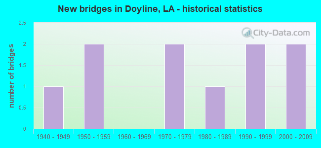
- New bridges - historical statistics
- 11940-1949
- 21950-1959
- 21970-1979
- 11980-1989
- 21990-1999
- 22000-2009


- Bridge Condition - Deck
- 14.3%Good
- 57.1%Satisfactory
- 28.6%Fair

- Bridge Condition - Superstructure
- 85.7%Satisfactory
- 14.3%Fair

- Bridge Condition - Substructure
- 14.3%Good
- 57.1%Satisfactory
- 28.6%Fair

- Bridge Condition - Channel
- 42.9%Good
- 42.9%Satisfactory
- 14.3%Fair

- Bridge Condition - Culverts
- 33.3%Good
- 66.7%Satisfactory
Find on map >> Show street view
Structure Number: 46001220200621, Location: 1.4 MI WEST OF LA 163 (Lat: 32.536131, Lng: -93.435000), Route carried "on" structure: State highway 164, Year Built: 1943, Status: Open, Structure Length: 1.07m (3.51ft), Average Daily Traffic: 3,400 (year 2016), Truck Traffic: 19%, Average Future Daily Traffic: 2,100 (year 2036), Design Load: H 15, Features Intersected: DRAIN
Minimum Vertical Clearance: 30+ m (98+ ft), Kilometerpoint: 1.053, Lanes on structure: 2, Owner: State Highway Agency, Approaching Roadway Width: 12.2m (40.0ft), Material/Design: Concrete, Design/Construction: Culvert, Number Of Spans In Main Unit: 6, Length of Maximum Span: 1.5m (4.9ft), Curb-To-Curb Width: 11.6m (38.1ft), Out-to-Out Width: 12.2m (40.0ft)
Condition: Channel: Good, Culverts: Good, Operating Rating: 42.1 metric tons, Method Used To Determine Operating Rating: Load and Resistance Factor Rating (LRFR) rating reported by rating factor(RF) method using HL-93 loadings, Inventory Rating: 32.4 metric tons, Method Used To Determine Inventory Rating: Load and Resistance Factor Rating (LRFR) rating reported by rating factor(RF) method using HL-93 loadings, Structural Evaluation: Better than present minimum criteria, Deck Geometry: Somewhat better than minimum adequacy, Waterway Adequacy: Better than present minimum criteria, Approach Roadway Alignment: Equal to present desirable criteria, Designated Inspection Frequency: Every 24 months, Inspection Date: September 2020, Deck Structure Type: Concrete Cast-file-Place
Find on map >> Show street view
Structure Number: 46001220302131, Location: 2.13 M EAST OF HWY 163 (Lat: 32.539231, Lng: -93.373800), Route carried "on" structure: State highway 164, Year Built: 1991, Status: Open, Structure Length: 3.47m (11.38ft), Average Daily Traffic: 3,100 (year 2016), Truck Traffic: 19%, Average Future Daily Traffic: 1,860 (year 2036), Design Load: HS 20, Features Intersected: BOONE CREEK
Minimum Vertical Clearance: 30+ m (98+ ft), Kilometerpoint: 3.495, Lanes on structure: 2, Owner: State Highway Agency, Approaching Roadway Width: 10.4m (34.1ft), Material/Design: Concrete, Design/Construction: Slab, Number Of Spans In Main Unit: 6, Length of Maximum Span: 5.8m (19.0ft), Curb-To-Curb Width: 9.8m (32.2ft), Out-to-Out Width: 10.6m (34.8ft)
Condition: Deck: Satisfactory, Superstructure: Satisfactory, Substructure: Fair, Channel: Good, Operating Rating: 89.8 metric tons, Method Used To Determine Operating Rating: Load Factor (LF), Inventory Rating: 57.1 metric tons, Method Used To Determine Inventory Rating: Load Factor (LF), Structural Evaluation: Somewhat better than minimum adequacy, Deck Geometry: Meets minimum limits, Waterway Adequacy: High priority of corrective action, Approach Roadway Alignment: Equal to present desirable criteria, Designated Inspection Frequency: Every 24 months, Inspection Date: September 2021, Deck Structure Type: Concrete Precast Panels
Find on map >> Show street view
Structure Number: 46004510300791, Location: .79 MI WEST OF US 371 (Lat: 32.578761, Lng: -93.432500), Route carried "on" structure: Interstate 20, Year Built: 2004, Status: Open, Structure Length: 6.37m (20.90ft), Average Daily Traffic: 24,050 (year 2016), Truck Traffic: 36%, Average Future Daily Traffic: 16,848 (year 2036), Design Load: HS 20, Features Intersected: GOODWILL ROAD
Minimum Vertical Clearance: 30+ m (98+ ft), Kilometerpoint: 1.299, Lanes on structure: 2, Lanes under structure: 2, Base Highway Network: Yes (Inventory Route: 451-03-1, Subroute: 10), Owner: State Highway Agency, Approaching Roadway Width: 12.2m (40.0ft), Skew: 18 degrees, Material/Design: Prestressed concrete, Design/Construction: Stringer/Multi-beam, Number Of Spans In Main Unit: 3, Length of Maximum Span: 32.0m (105.0ft), Curb-To-Curb Width: 12.1m (39.7ft), Out-to-Out Width: 13.0m (42.7ft)
Condition: Deck: Satisfactory, Superstructure: Satisfactory, Substructure: Satisfactory, Operating Rating: 82.5 metric tons, Method Used To Determine Operating Rating: Load Factor (LF), Inventory Rating: 38.1 metric tons, Method Used To Determine Inventory Rating: Load Factor (LF), Structural Evaluation: Equal to present minimum criteria, Deck Geometry: Equal to present minimum criteria, Underclear: Better than present minimum criteria, Approach Roadway Alignment: Equal to present desirable criteria, Designated Inspection Frequency: Every 24 months, Inspection Date: September 2021, Deck Structure Type: Concrete Cast-file-Place
Find on map >> Show street view
Structure Number: 46004510300792, Location: .79 MI WEST OF US 371 (Lat: 32.579069, Lng: -93.431700), Route carried "on" structure: Interstate 20, Year Built: 2004, Status: Open, Structure Length: 6.37m (20.90ft), Average Daily Traffic: 24,050 (year 2016), Truck Traffic: 36%, Average Future Daily Traffic: 16,848 (year 2036), Design Load: HS 20, Features Intersected: GOODWILL ROAD
Minimum Vertical Clearance: 30+ m (98+ ft), Kilometerpoint: 24.660, Lanes on structure: 2, Lanes under structure: 2, Base Highway Network: Yes (Inventory Route: 451-03-2, Subroute: 10), Owner: State Highway Agency, Approaching Roadway Width: 12.2m (40.0ft), Skew: 10 degrees, Material/Design: Prestressed concrete, Design/Construction: Stringer/Multi-beam, Number Of Spans In Main Unit: 3, Length of Maximum Span: 32.0m (105.0ft), Curb-To-Curb Width: 12.1m (39.7ft), Out-to-Out Width: 13.0m (42.7ft)
Condition: Deck: Good, Superstructure: Satisfactory, Substructure: Good, Operating Rating: 82.5 metric tons, Method Used To Determine Operating Rating: Load Factor (LF), Inventory Rating: 38.1 metric tons, Method Used To Determine Inventory Rating: Load Factor (LF), Structural Evaluation: Equal to present minimum criteria, Deck Geometry: Equal to present minimum criteria, Underclear: High priority of corrective action, Approach Roadway Alignment: Equal to present desirable criteria, Designated Inspection Frequency: Every 24 months, Inspection Date: September 2021, Deck Structure Type: Concrete Cast-file-Place
Find on map >> Show street view
Structure Number: 46004510303141, Location: 3.14 MI WEST OF US 371 (Lat: 32.582519, Lng: -93.392650), Route carried "on" structure: Interstate 20, Year Built: 1975, Status: Open, Structure Length: 16.79m (55.09ft), Average Daily Traffic: 24,050 (year 2016), Truck Traffic: 36%, Average Future Daily Traffic: 16,848 (year 2036), Design Load: HS 20, Features Intersected: US 80
Minimum Vertical Clearance: 30+ m (98+ ft), Kilometerpoint: 5.040, Lanes on structure: 2, Lanes under structure: 4, Base Highway Network: Yes (Inventory Route: 451-03-1, Subroute: 10), Owner: State Highway Agency, Approaching Roadway Width: 12.2m (40.0ft), Skew: 10 degrees, Material/Design: Steel continuous, Design/Construction: Girder and Floorbeam System, Number Of Spans In Main Unit: 4, Length of Maximum Span: 53.3m (174.9ft), Curb-To-Curb Width: 12.1m (39.7ft), Out-to-Out Width: 13.0m (42.7ft)
Condition: Deck: Satisfactory, Superstructure: Satisfactory, Substructure: Satisfactory, Operating Rating: 74.4 metric tons, Method Used To Determine Operating Rating: Load Factor (LF), Inventory Rating: 44.4 metric tons, Method Used To Determine Inventory Rating: Load Factor (LF), Structural Evaluation: Equal to present minimum criteria, Deck Geometry: Equal to present minimum criteria, Underclear: Better than present minimum criteria, Approach Roadway Alignment: Equal to present desirable criteria, Designated Inspection Frequency: Every 24 months, Inspection Date: September 2021, Deck Structure Type: Concrete Cast-file-Place
Find on map >> Show street view
Structure Number: 46032289932471, Location: 0.6 MI W OF HWY 163 (Lat: 32.482300, Lng: -93.412369), Route carried "on" structure: County highway , Year Built: 1959, Status: Open, Structure Length: 1.10m (3.61ft), Average Daily Traffic: 281 (year 2020), Average Future Daily Traffic: 138 (year 2036), Design Load: HS 20, Features Intersected: PRAIRIE BAYOU, Facility Carried by Structure: Montgomery Xing
Minimum Vertical Clearance: 30+ m (98+ ft), Kilometerpoint: 0.000, Lanes on structure: 2, Owner: County Highway Agency, Approaching Roadway Width: 12.2m (40.0ft), Material/Design: Concrete, Design/Construction: Culvert, Number Of Spans In Main Unit: 4, Length of Maximum Span: 2.7m (8.9ft), Curb-To-Curb Width: 7.6m (24.9ft), Out-to-Out Width: 12.2m (40.0ft)
Condition: Channel: Satisfactory, Culverts: Satisfactory, Operating Rating: 42.1 metric tons, Method Used To Determine Operating Rating: Load and Resistance Factor Rating (LRFR) rating reported by rating factor(RF) method using HL-93 loadings, Inventory Rating: 32.4 metric tons, Method Used To Determine Inventory Rating: Load and Resistance Factor Rating (LRFR) rating reported by rating factor(RF) method using HL-93 loadings, Structural Evaluation: Equal to present minimum criteria, Deck Geometry: Somewhat better than minimum adequacy, Waterway Adequacy: Equal to present desirable criteria, Approach Roadway Alignment: Equal to present desirable criteria, Designated Inspection Frequency: Every 24 months, Inspection Date: July 2021, Deck Structure Type: Concrete Cast-file-Place
Find on map >> Show street view
Structure Number: 46032289932481, Location: 0.8 MI W OF HWY 163 (Lat: 32.482569, Lng: -93.415711), Route carried "on" structure: County highway , Year Built: 1959, Status: Open, Structure Length: 0.76m (2.49ft), Average Daily Traffic: 281 (year 2020), Average Future Daily Traffic: 138 (year 2036), Design Load: HS 20, Features Intersected: TRIB TO PRAIRIE BAYOU, Facility Carried by Structure: Montgomery Xing
Minimum Vertical Clearance: 30+ m (98+ ft), Kilometerpoint: 0.000, Lanes on structure: 2, Owner: County Highway Agency, Approaching Roadway Width: 10.7m (35.1ft), Skew: 30 degrees, Material/Design: Concrete, Design/Construction: Culvert, Number Of Spans In Main Unit: 3, Length of Maximum Span: 2.4m (7.9ft)
Condition: Channel: Fair, Culverts: Satisfactory, Operating Rating: 31.1 metric tons, Method Used To Determine Operating Rating: Load and Resistance Factor Rating (LRFR) rating reported by rating factor(RF) method using HL-93 loadings, Inventory Rating: 24.0 metric tons, Method Used To Determine Inventory Rating: Load and Resistance Factor Rating (LRFR) rating reported by rating factor(RF) method using HL-93 loadings, Structural Evaluation: Equal to present minimum criteria, Waterway Adequacy: Equal to present desirable criteria, Approach Roadway Alignment: Equal to present desirable criteria, Designated Inspection Frequency: Every 24 months, Inspection Date: July 2021, Deck Structure Type: Concrete Cast-file-Place
Find on map >> Show street view
Structure Number: 46032311931731, Location: 2 MI E OF HWY 163 (Lat: 32.519750, Lng: -93.372150), Route carried "on" structure: County highway , Year Built: 1979, Status: Posted for load, Structure Length: 1.80m (5.91ft), Average Daily Traffic: 86 (year 2020), Average Future Daily Traffic: 42 (year 2036), Design Load: H 20, Features Intersected: TRIB TO TAD POLE LAKE, Facility Carried by Structure: Bistineau Terrace
Minimum Vertical Clearance: 30+ m (98+ ft), Kilometerpoint: 0.000, Lanes on structure: 2, Owner: County Highway Agency, Approaching Roadway Width: 7.3m (24.0ft), Material/Design: Wood or Timber, Design/Construction: Stringer/Multi-beam, Number Of Spans In Main Unit: 3, Length of Maximum Span: 5.8m (19.0ft), Curb-To-Curb Width: 7.3m (24.0ft), Out-to-Out Width: 7.7m (25.3ft)
Condition: Deck: Fair, Superstructure: Satisfactory, Substructure: Fair, Channel: Satisfactory, Operating Rating: 31.7 metric tons, Method Used To Determine Operating Rating: Allowable Stress (AS), Inventory Rating: 20.9 metric tons, Method Used To Determine Inventory Rating: Allowable Stress (AS), Structural Evaluation: Somewhat better than minimum adequacy, Deck Geometry: Equal to present minimum criteria, Waterway Adequacy: Equal to present desirable criteria, Approach Roadway Alignment: Equal to present desirable criteria, Bridge Posting: Required (Relationship of Operating Rating to Maximum Legal Load: 0.1 - 9.9% below), Designated Inspection Frequency: Every 24 months, Inspection Date: July 2021, Deck Structure Type: Wood or Timber, Wearing Surface/Protective System: Wearing Surface: Other
Find on map >> Show street view
Structure Number: 46032325932261, Location: 5.5 MI. SE OF US 80 (Lat: 32.542261, Lng: -93.377069), Route carried "on" structure: County highway , Year Built: 1988, Status: Open, Structure Length: 3.47m (11.38ft), Average Daily Traffic: 25 (year 2021), Average Future Daily Traffic: 28 (year 2041), Design Load: HS 20, Features Intersected: BOONE CREEK, Facility Carried by Structure: Sewage Disposal Rd
Minimum Vertical Clearance: 30+ m (98+ ft), Kilometerpoint: 0.000, Lanes on structure: 2, Base Highway Network: Yes, Owner: State Agenciy, Approaching Roadway Width: 4.3m (14.1ft), Material/Design: Concrete, Design/Construction: Slab, Number Of Spans In Main Unit: 6, Length of Maximum Span: 5.8m (19.0ft), Curb-To-Curb Width: 7.4m (24.3ft), Out-to-Out Width: 8.3m (27.2ft)
Condition: Deck: Satisfactory, Superstructure: Satisfactory, Substructure: Satisfactory, Channel: Satisfactory, Operating Rating: 62.2 metric tons, Method Used To Determine Operating Rating: Load and Resistance Factor Rating (LRFR) rating reported by rating factor(RF) method using HL-93 loadings, Inventory Rating: 48.0 metric tons, Method Used To Determine Inventory Rating: Load and Resistance Factor Rating (LRFR) rating reported by rating factor(RF) method using HL-93 loadings, Structural Evaluation: Equal to present minimum criteria, Deck Geometry: Equal to present minimum criteria, Waterway Adequacy: Equal to present desirable criteria, Approach Roadway Alignment: Equal to present desirable criteria, Designated Inspection Frequency: Every 24 months, Inspection Date: August 2021, Deck Structure Type: Concrete Cast-file-Place
Find on map >> Show street view
Structure Number: 46032331932271, Location: 3.5 MI. SE OF US 80 (Lat: 32.551900, Lng: -93.378989), Route carried "on" structure: County highway , Year Built: 1990, Status: Posted for load, Structure Length: 2.90m (9.51ft), Average Daily Traffic: 25 (year 2021), Average Future Daily Traffic: 28 (year 2041), Design Load: HS 20, Features Intersected: BOONE CREEK, Facility Carried by Structure: Victory Rd
Minimum Vertical Clearance: 30+ m (98+ ft), Kilometerpoint: 0.000, Lanes on structure: 2, Base Highway Network: Yes, Owner: State Agenciy, Approaching Roadway Width: 6.1m (20.0ft), Material/Design: Concrete, Design/Construction: Slab, Number Of Spans In Main Unit: 5, Length of Maximum Span: 5.8m (19.0ft), Curb-To-Curb Width: 8.6m (28.2ft), Out-to-Out Width: 9.4m (30.8ft)
Condition: Deck: Fair, Superstructure: Fair, Substructure: Satisfactory, Channel: Good, Operating Rating: 46.3 metric tons, Method Used To Determine Operating Rating: Load and Resistance Factor Rating (LRFR) rating reported by rating factor(RF) method using HL-93 loadings, Inventory Rating: 35.6 metric tons, Method Used To Determine Inventory Rating: Load and Resistance Factor Rating (LRFR) rating reported by rating factor(RF) method using HL-93 loadings, Structural Evaluation: Somewhat better than minimum adequacy, Deck Geometry: Better than present minimum criteria, Waterway Adequacy: Equal to present desirable criteria, Approach Roadway Alignment: Equal to present desirable criteria, Designated Inspection Frequency: Every 24 months, Inspection Date: August 2021, Deck Structure Type: Concrete Precast Panels
Find on map >> Show street view
Structure Number: 46004510303141, Location: 3.32 MI W OF US 371 (Lat: 32.582961, Lng: -93.391819), Route carried "under" structure: US 80, Structure Length: 0. m, Average Daily Traffic: 2,738 (year 2019), Features Intersected: US 80 WB UNDER I-20 EB
Minimum Vertical Clearance: 6.10m (20.01ft), Kilometerpoint: 10.218, Lanes on structure: 2, Lanes under structure: 4, Length of Maximum Span: 0.0m
Find on map >> Show street view
Structure Number: 46004510303141, Location: 5.812 MI E OF LA 164 (Lat: 32.582589, Lng: -93.391650), Route carried "under" structure: US 80, Structure Length: 0. m, Average Daily Traffic: 2,738 (year 2019), Features Intersected: US 80 EB UNDER I-20 EB
Minimum Vertical Clearance: 5.85m (19.19ft), Kilometerpoint: 5.333, Lanes on structure: 2, Lanes under structure: 4, Length of Maximum Span: 0.0m
Find on map >> Show street view
Structure Number: 46004510303142, Location: 3.31 MI W OF US 371 (Lat: 32.583000, Lng: -93.391250), Route carried "under" structure: US 80, Structure Length: 0. m, Average Daily Traffic: 2,738 (year 2019), Features Intersected: US 80 WB UNDER I-20 WB
Minimum Vertical Clearance: 5.79m (19.00ft), Kilometerpoint: 10.155, Lanes on structure: 2, Lanes under structure: 4, Length of Maximum Span: 0.0m
Find on map >> Show street view
Structure Number: 46004510303142, Location: 5.82 MI E OF LA 6164 (Lat: 32.582900, Lng: -93.391031), Route carried "under" structure: US 80, Structure Length: 0. m, Average Daily Traffic: 2,738 (year 2019), Features Intersected: US 80 EB UNDER I-20 WB
Minimum Vertical Clearance: 5.76m (18.90ft), Kilometerpoint: 5.729, Lanes on structure: 2, Lanes under structure: 4, Length of Maximum Span: 0.0m