Bridge Statistics for Drayton, North Dakota (ND)
Condition, Traffic, Stress, Structural Evaluation, Project Costs
- National Bridge Inventory (NBI) Statistics
- 20Number of bridges
- 512ft / 156mTotal length
- $3,372,000Total costs
- 34,712Total average daily traffic
- 12,120Total average daily truck traffic
- National Bridge Inventory (NBI) Registered Bridges for Drayton
- No street view available for this location
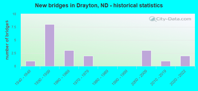
- New bridges - historical statistics
- 11940-1949
- 81950-1959
- 31960-1969
- 21970-1979
- 32000-2009
- 12010-2019
- 22020-2022

- Reconstructed bridges - Historical Statistics
- 11970-1979
- 11980-1989
- 11990-1999
- 12000-2009


- Bridge Condition - Deck
- 22.2%Very good
- 55.6%Good
- 11.1%Satisfactory
- 11.1%Fair

- Bridge Condition - Superstructure
- 11.1%Very good
- 22.2%Good
- 44.4%Satisfactory
- 22.2%Fair

- Bridge Condition - Substructure
- 11.1%Good
- 33.3%Satisfactory
- 55.6%Fair

- Bridge Condition - Channel
- 11.1%Excellent
- 22.2%Very good
- 33.3%Good
- 33.3%Satisfactory

- Bridge Condition - Culverts
- 33.3%Very good
- 33.3%Good
- 33.3%Satisfactory
Find on map >> Show street view
Structure Number: 3413328, Location: 3 WEST 2 SOUTH PITTSBURG (Lat: 48.607747, Lng: -97.233811), Route carried "on" structure: County highway , Year Built: 1946, Year Reconstructed: 1976, Status: Open, Structure Length: 1.16m (3.81ft), Average Daily Traffic: 24 (year 2014), Average Future Daily Traffic: 24 (year 2034), Features Intersected: DITCH, Facility Carried by Structure: COUNTY HIGHWAY
Minimum Vertical Clearance: 30+ m (98+ ft), Kilometerpoint: 0.000, Lanes on structure: 2, Owner: County Highway Agency, Approaching Roadway Width: 4.9m (16.1ft), Material/Design: Prestressed concrete, Design/Construction: Box Beam or Girders - Multiple, Number Of Spans In Main Unit: 1, Length of Maximum Span: 10.7m (35.1ft), Curb-To-Curb Width: 8.3m (27.2ft), Out-to-Out Width: 8.3m (27.2ft)
Condition: Deck: Satisfactory, Superstructure: Satisfactory, Substructure: Satisfactory, Channel: Satisfactory, Structural Evaluation: Equal to present minimum criteria, Deck Geometry: Equal to present minimum criteria, Waterway Adequacy: Equal to present desirable criteria, Approach Roadway Alignment: Equal to present desirable criteria, Designated Inspection Frequency: Every 24 months, Inspection Date: May 2020
Find on map >> Show street view
Structure Number: 3413428, Location: 2 WEST 2 SOUTH PITTSBURG (Lat: 48.607636, Lng: -97.211889), Route carried "on" structure: County highway , Year Built: 1950, Status: Open, Structure Length: 1.31m (4.30ft), Average Daily Traffic: 24 (year 2014), Average Future Daily Traffic: 24 (year 2034), Design Load: H 20, Features Intersected: DRAIN DITCH, Facility Carried by Structure: COUNTY ROAD
Minimum Vertical Clearance: 30+ m (98+ ft), Kilometerpoint: 0.000, Lanes on structure: 2, Owner: County Highway Agency, Approaching Roadway Width: 4.9m (16.1ft), Material/Design: Steel, Design/Construction: Stringer/Multi-beam, Number Of Spans In Main Unit: 2, Length of Maximum Span: 6.1m (20.0ft), Curb or Sidewalk Widths: Left: 0.0m, Right: 0.3m (1.0ft), Curb-To-Curb Width: 6.7m (22.0ft), Out-to-Out Width: 7.3m (24.0ft)
Condition: Deck: Good, Superstructure: Satisfactory, Substructure: Fair, Channel: Satisfactory, Operating Rating: 55.4 metric tons, Method Used To Determine Operating Rating: Load Factor (LF), Inventory Rating: 33.2 metric tons, Method Used To Determine Inventory Rating: Load Factor (LF), Structural Evaluation: Somewhat better than minimum adequacy, Deck Geometry: Somewhat better than minimum adequacy, Waterway Adequacy: Better than present minimum criteria, Approach Roadway Alignment: Equal to present desirable criteria, Designated Inspection Frequency: Every 24 months, Inspection Date: May 2020, Deck Structure Type: Wood or Timber, Wearing Surface/Protective System: Wearing Surface: Wood or Timber
Find on map >> Show street view
Structure Number: 3413528, Location: 3 NORTH OF DRAYTON (Lat: 48.607633, Lng: -97.190072), Route carried "on" structure: County highway , Year Built: 1958, Year Reconstructed: 2008, Status: Open, Structure Length: 1.25m (4.10ft), Average Daily Traffic: 50 (year 2014), Average Future Daily Traffic: 50 (year 2034), Features Intersected: DITCH, Facility Carried by Structure: COUNTY ROAD
Minimum Vertical Clearance: 30+ m (98+ ft), Kilometerpoint: 0.000, Lanes on structure: 2, Owner: County Highway Agency, Approaching Roadway Width: 5.5m (18.0ft), Material/Design: Steel continuous, Design/Construction: Stringer/Multi-beam, Number Of Spans In Main Unit: 2, Length of Maximum Span: 5.8m (19.0ft), Curb or Sidewalk Widths: Left: 0.2m (0.7ft), Right: 0.2m (0.7ft), Curb-To-Curb Width: 7.0m (23.0ft), Out-to-Out Width: 7.3m (24.0ft)
Condition: Deck: Good, Superstructure: Fair, Substructure: Fair, Channel: Satisfactory, Operating Rating: 60.6 metric tons, Method Used To Determine Operating Rating: Load Factor (LF), Inventory Rating: 36.3 metric tons, Method Used To Determine Inventory Rating: Load Factor (LF), Structural Evaluation: Somewhat better than minimum adequacy, Deck Geometry: Somewhat better than minimum adequacy, Waterway Adequacy: Better than present minimum criteria, Approach Roadway Alignment: Somewhat better than minimum adequacy, Designated Inspection Frequency: Every 24 months, Inspection Date: November 2020, Deck Structure Type: Wood or Timber, Wearing Surface/Protective System: Wearing Surface: Wood or Timber
Find on map >> Show street view
Structure Number: 3413628, Location: 2 NORTH OF DRAYTON (Lat: 48.607569, Lng: -97.178694), Route carried "on" structure: County highway 3428, Year Built: 2020, Status: Open, Structure Length: 0.76m (2.49ft), Average Daily Traffic: 160 (year 2019), Truck Traffic: 12%, Average Future Daily Traffic: 180 (year 2039), Design Load: HL 93, Features Intersected: DITCH, Facility Carried by Structure: COUNTY HIGHWAY
Minimum Vertical Clearance: 30+ m (98+ ft), Kilometerpoint: 22.204, Lanes on structure: 2, Owner: County Highway Agency, Approaching Roadway Width: 7.3m (24.0ft), Material/Design: Concrete, Design/Construction: Culvert, Number Of Spans In Main Unit: 2, Length of Maximum Span: 3.7m (12.1ft)
Condition: Channel: Good, Culverts: Good, Operating Rating: 54.4 metric tons, Method Used To Determine Operating Rating: Field evaluation and documented engineering judgment, Inventory Rating: 32.7 metric tons, Method Used To Determine Inventory Rating: Field evaluation and documented engineering judgment, Structural Evaluation: Better than present minimum criteria, Waterway Adequacy: Equal to present desirable criteria, Approach Roadway Alignment: Equal to present desirable criteria, Designated Inspection Frequency: Every 24 months, Inspection Date: May 2021
Find on map >> Show street view
Structure Number: 34136281, Location: 2 NORTH OF DRAYTON (Lat: 48.607592, Lng: -97.168189), Route carried "on" structure: County highway 3428, Year Built: 1977, Status: Open, Structure Length: 1.25m (4.10ft), Average Daily Traffic: 24 (year 2014), Average Future Daily Traffic: 24 (year 2034), Features Intersected: DRAIN DITCH, Facility Carried by Structure: COUNTY ROAD
Minimum Vertical Clearance: 30+ m (98+ ft), Kilometerpoint: 4.827, Lanes on structure: 2, Owner: County Highway Agency, Approaching Roadway Width: 3.7m (12.1ft), Material/Design: Steel, Design/Construction: Stringer/Multi-beam, Number Of Spans In Main Unit: 2, Length of Maximum Span: 5.8m (19.0ft), Curb or Sidewalk Widths: Left: 0.1m (0.3ft), Right: 0.1m (0.3ft), Curb-To-Curb Width: 7.0m (23.0ft), Out-to-Out Width: 7.3m (24.0ft)
Condition: Deck: Fair, Superstructure: Fair, Substructure: Fair, Channel: Very good, Operating Rating: 42.1 metric tons, Method Used To Determine Operating Rating: Load Factor (LF), Inventory Rating: 25.2 metric tons, Method Used To Determine Inventory Rating: Load Factor (LF), Structural Evaluation: Somewhat better than minimum adequacy, Deck Geometry: Somewhat better than minimum adequacy, Waterway Adequacy: Better than present minimum criteria, Approach Roadway Alignment: Equal to present desirable criteria, Designated Inspection Frequency: Every 24 months, Inspection Date: May 2020, Deck Structure Type: Wood or Timber, Wearing Surface/Protective System: Wearing Surface: Wood or Timber
Find on map >> Show street view
Structure Number: 3413728, Location: 2 EAST 2 SOUTH PITTSBURG (Lat: 48.607686, Lng: -97.151389), Route carried "on" structure: County highway , Year Built: 1969, Status: Open, Structure Length: 0.98m (3.22ft), Average Daily Traffic: 5 (year 2014), Average Future Daily Traffic: 5 (year 2034), Features Intersected: DRAIN DITCH, Facility Carried by Structure: COUNTY ROAD
Minimum Vertical Clearance: 30+ m (98+ ft), Kilometerpoint: 0.000, Lanes on structure: 2, Owner: County Highway Agency, Approaching Roadway Width: 3.7m (12.1ft), Material/Design: Concrete, Design/Construction: Channel Beam, Number Of Spans In Main Unit: 1, Length of Maximum Span: 9.1m (29.9ft), Curb or Sidewalk Widths: Left: 0.2m (0.7ft), Right: 0.2m (0.7ft), Curb-To-Curb Width: 7.4m (24.3ft), Out-to-Out Width: 7.9m (25.9ft)
Condition: Deck: Good, Superstructure: Very good, Substructure: Fair, Channel: Very good, Operating Rating: 56.2 metric tons, Method Used To Determine Operating Rating: Load Factor (LF), Inventory Rating: 33.6 metric tons, Method Used To Determine Inventory Rating: Load Factor (LF), Structural Evaluation: Somewhat better than minimum adequacy, Deck Geometry: Equal to present minimum criteria, Waterway Adequacy: Equal to present desirable criteria, Approach Roadway Alignment: Equal to present minimum criteria, Designated Inspection Frequency: Every 24 months, Inspection Date: May 2020
Find on map >> Show street view
Structure Number: 5015203, Location: 5 EAST 1 NORTH (Lat: 48.499711, Lng: -97.191203), Route carried "on" structure: County highway , Year Built: 1972, Status: Open, Structure Length: 0.79m (2.59ft), Average Daily Traffic: 5 (year 2017), Average Future Daily Traffic: 5 (year 2037), Design Load: HS 20, Features Intersected: CREEK, Facility Carried by Structure: COUNTY HIGHWAY
Minimum Vertical Clearance: 30+ m (98+ ft), Kilometerpoint: 0.000, Lanes on structure: 2, Owner: County Highway Agency, Approaching Roadway Width: 6.1m (20.0ft), Material/Design: Concrete, Design/Construction: Culvert, Number Of Spans In Main Unit: 3, Length of Maximum Span: 2.4m (7.9ft)
Condition: Channel: Good, Culverts: Satisfactory, Operating Rating: 54.0 metric tons, Method Used To Determine Operating Rating: Load Factor (LF), Inventory Rating: 32.4 metric tons, Method Used To Determine Inventory Rating: Load Factor (LF), Structural Evaluation: Equal to present minimum criteria, Waterway Adequacy: Equal to present desirable criteria, Approach Roadway Alignment: Equal to present desirable criteria, Designated Inspection Frequency: Every 24 months, Inspection Date: April 2021
Find on map >> Show street view
Structure Number: 29184038, Location: 3 SOUTH ND 66 (Lat: 48.528333, Lng: -97.185000), Route carried "on" structure: State highway 44, Year Built: 2004, Status: Open, Structure Length: 7.80m (25.59ft), Average Daily Traffic: 700 (year 2019), Truck Traffic: 12%, Average Future Daily Traffic: 855 (year 2039), Design Load: HS 25 or greater, Features Intersected: I-29/HERRICK INTERCHANGE
Minimum Vertical Clearance: 30+ m (98+ ft), Kilometerpoint: 47.353, Lanes on structure: 2, Lanes under structure: 4, Owner: State Highway Agency, Approaching Roadway Width: 7.3m (24.0ft), Material/Design: Prestressed concrete continuous, Design/Construction: Stringer/Multi-beam, Number Of Spans In Main Unit: 2, Length of Maximum Span: 37.8m (124.0ft), Curb-To-Curb Width: 11.0m (36.1ft), Out-to-Out Width: 11.8m (38.7ft)
Condition: Deck: Very good, Superstructure: Good, Substructure: Good, Operating Rating: 89.8 metric tons, Method Used To Determine Operating Rating: Load Factor (LF), Inventory Rating: 57.9 metric tons, Method Used To Determine Inventory Rating: Load Factor (LF), Structural Evaluation: Better than present minimum criteria, Deck Geometry: Better than present minimum criteria, Underclear: Better than present minimum criteria, Approach Roadway Alignment: Better than present minimum criteria, Designated Inspection Frequency: Every 24 months, Inspection Date: November 2021, Deck Structure Type: Concrete Cast-file-Place, Wearing Surface/Protective System: Wearing Surface: Monolithic Concrete, Deck Protection: Epoxy Coated Reinforcing
Find on map >> Show street view
Structure Number: 29186881, Location: JUNCTION ND 66 (Lat: 48.571667, Lng: -97.185000), Route carried "on" structure: State highway 66, Year Built: 1959, Year Reconstructed: 1986, Status: Open, Structure Length: 7.44m (24.41ft), Average Daily Traffic: 1,830 (year 2019), Truck Traffic: 10%, Average Future Daily Traffic: 1,830 (year 2039), Design Load: HS 20, Features Intersected: I-29/DRAYTON INTERCHANGE
Minimum Vertical Clearance: 30+ m (98+ ft), Kilometerpoint: 220.325, Lanes on structure: 2, Lanes under structure: 4, Base Highway Network: Yes, Owner: State Highway Agency, Approaching Roadway Width: 12.2m (40.0ft), Material/Design: Prestressed concrete continuous, Design/Construction: Stringer/Multi-beam, Number Of Spans In Main Unit: 4, Length of Maximum Span: 17.7m (58.1ft), Curb-To-Curb Width: 12.2m (40.0ft), Out-to-Out Width: 13.0m (42.7ft)
Condition: Deck: Good, Superstructure: Satisfactory, Substructure: Satisfactory, Operating Rating: 80.7 metric tons, Method Used To Determine Operating Rating: Load Factor (LF), Inventory Rating: 48.4 metric tons, Method Used To Determine Inventory Rating: Load Factor (LF), Structural Evaluation: Equal to present minimum criteria, Deck Geometry: Better than present minimum criteria, Underclear: Meets minimum limits, Approach Roadway Alignment: Better than present minimum criteria, Designated Inspection Frequency: Every 24 months, Inspection Date: November 2021, Deck Structure Type: Concrete Cast-file-Place, Wearing Surface/Protective System: Wearing Surface: Low Slump Concrete
Find on map >> Show street view
Structure Number: 29189439, Location: 3 NORTH ND 66 (Lat: 48.607531, Lng: -97.180369), Route carried "on" structure: Interstate 29, Year Built: 2021, Status: Open, Structure Length: 0.92m (3.02ft), Average Daily Traffic: 3,825 (year 2018), Truck Traffic: 41%, Average Future Daily Traffic: 5,295 (year 2038), Design Load: HL 93, Features Intersected: DRAINAGE DITCH
Minimum Vertical Clearance: 30+ m (98+ ft), Kilometerpoint: 304.873, Lanes on structure: 4, Base Highway Network: Yes, Owner: State Highway Agency, Approaching Roadway Width: 11.6m (38.1ft), Skew: 10 degrees, Material/Design: Concrete, Design/Construction: Culvert, Number Of Spans In Main Unit: 2, Length of Maximum Span: 4.3m (14.1ft)
Condition: Channel: Excellent, Culverts: Very good, Operating Rating: 77.8 metric tons, Method Used To Determine Operating Rating: Load and Resistance Factor Rating (LRFR) rating reported by rating factor(RF) method using HL-93 loadings, Inventory Rating: 58.3 metric tons, Method Used To Determine Inventory Rating: Load and Resistance Factor Rating (LRFR) rating reported by rating factor(RF) method using HL-93 loadings, Structural Evaluation: Equal to present desirable criteria, Waterway Adequacy: Equal to present desirable criteria, Approach Roadway Alignment: Equal to present desirable criteria, Designated Inspection Frequency: Every 24 months, Inspection Date: October 2021
Find on map >> Show street view
Structure Number: 29190955, Location: 4 NORTH OF ND 66 (Lat: 48.630000, Lng: -97.183333), Route carried "on" structure: County highway 3428, Year Built: 1959, Year Reconstructed: 1997, Status: Open, Structure Length: 7.47m (24.51ft), Average Daily Traffic: 200 (year 2019), Truck Traffic: 14%, Average Future Daily Traffic: 200 (year 2039), Design Load: HS 20, Features Intersected: I-29/PITTSBURG INT, Facility Carried by Structure: COUNTY HIGHWAY
Minimum Vertical Clearance: 5.13m (16.83ft), Kilometerpoint: 19.791, Lanes on structure: 2, Lanes under structure: 4, Owner: State Highway Agency, Approaching Roadway Width: 7.3m (24.0ft), Material/Design: Prestressed concrete continuous, Design/Construction: Stringer/Multi-beam, Number Of Spans In Main Unit: 4, Length of Maximum Span: 17.7m (58.1ft), Curb-To-Curb Width: 7.3m (24.0ft), Out-to-Out Width: 8.8m (28.9ft)
Condition: Deck: Good, Superstructure: Satisfactory, Substructure: Fair, Operating Rating: 49.6 metric tons, Method Used To Determine Operating Rating: Load Factor (LF), Inventory Rating: 29.7 metric tons, Method Used To Determine Inventory Rating: Load Factor (LF), Structural Evaluation: Somewhat better than minimum adequacy, Deck Geometry: Somewhat better than minimum adequacy, Underclear: High priority of corrective action, Approach Roadway Alignment: Better than present minimum criteria, Designated Inspection Frequency: Every 24 months, Inspection Date: November 2021, Deck Structure Type: Concrete Cast-file-Place, Wearing Surface/Protective System: Wearing Surface: Low Slump Concrete
Find on map >> Show street view
Structure Number: 6613872, Location: 2 EAST OF I-29 (Lat: 48.571667, Lng: -97.148333), Route carried "on" structure: State highway 66, Year Built: 2010, Status: Open, Structure Length: 124.60m (408.79ft), Average Daily Traffic: 1,465 (year 2019), Truck Traffic: 16%, Average Future Daily Traffic: 1,645 (year 2039), Design Load: HS 25 or greater, Features Intersected: RED RIVER OF THE NORTH
Minimum Vertical Clearance: 30+ m (98+ ft), Kilometerpoint: 223.200, Lanes on structure: 2, Base Highway Network: Yes, Owner: State Highway Agency, Approaching Roadway Width: 11.0m (36.1ft), Material/Design: Steel continuous, Design/Construction: Stringer/Multi-beam, Number Of Spans In Main Unit: 4, Number Of Approach Spans: 33, Length of Maximum Span: 76.2m (250.0ft), Curb or Sidewalk Widths: Left: 0.5m (1.6ft), Right: 0.0m, Curb-To-Curb Width: 12.2m (40.0ft), Out-to-Out Width: 12.2m (40.0ft)
Condition: Deck: Very good, Superstructure: Good, Substructure: Satisfactory, Channel: Good, Operating Rating: 73.0 metric tons, Method Used To Determine Operating Rating: Load Factor (LF), Inventory Rating: 43.7 metric tons, Method Used To Determine Inventory Rating: Load Factor (LF), Structural Evaluation: Equal to present minimum criteria, Deck Geometry: Better than present minimum criteria, Waterway Adequacy: Equal to present desirable criteria, Approach Roadway Alignment: Better than present minimum criteria, Length Of Structure Improvement: 32.25m (105.81ft), Designated Inspection Frequency: Every 24 months, Underwater Inspection Frequency: Every 60 months, Inspection Date: May 2020, Underwater Inspection Date: August 2020, Bridge Improvement Cost: $2,248,000, Roadway Improvement Cost: $225,000, Total Project Cost: $3,372,000, Deck Structure Type: Concrete Cast-file-Place, Wearing Surface/Protective System: Wearing Surface: Monolithic Concrete
Find on map >> Show street view
Structure Number: 29184038, Location: 3 SOUTH ND 66 (Lat: 48.528333, Lng: -97.185000), Route carried "under" structure: Interstate 29, Year Built: 2004, Structure Length: 0. m, Average Daily Traffic: 3,850 (year 2011), Truck Traffic: 34%, Features Intersected: I-29/HERRICK INTERCHANGE, Facility Carried by Structure: ND HIGHWAY 44
Minimum Vertical Clearance: 5.22m (17.13ft), Kilometerpoint: 296.180, Lanes on structure: 2, Lanes under structure: 2, Material/Design: Prestressed concrete continuous, Design/Construction: Stringer/Multi-beam, Length of Maximum Span: 37.8m (124.0ft)
Find on map >> Show street view
Structure Number: 29184038, Location: 3 SOUTH ND 66 (Lat: 48.528333, Lng: -97.185000), Route carried "under" structure: Interstate 29, Year Built: 2004, Structure Length: 0. m, Average Daily Traffic: 3,850 (year 2011), Truck Traffic: 34%, Features Intersected: I-29/HERRICK INTERCHANGE, Facility Carried by Structure: ND HIGHWAY 44
Minimum Vertical Clearance: 5.14m (16.86ft), Kilometerpoint: 296.180, Lanes on structure: 2, Lanes under structure: 2, Material/Design: Prestressed concrete continuous, Design/Construction: Stringer/Multi-beam, Length of Maximum Span: 37.8m (124.0ft)
Find on map >> Show street view
Structure Number: 29184133 B, Location: 3 SOUTH ND 66 (Lat: 48.531667, Lng: -97.185000), Route carried "under" structure: Interstate 29, Year Built: 1961, Structure Length: 0. m, Average Daily Traffic: 3,500 (year 2012), Truck Traffic: 37%, Features Intersected: BNSF RAILROAD, Facility Carried by Structure: RAILROAD
Minimum Vertical Clearance: 5.19m (17.03ft), Kilometerpoint: 296.271, Lanes under structure: 2, Material/Design: Steel, Design/Construction: Girder and Floorbeam System, Length of Maximum Span: 20.7m (67.9ft)
Find on map >> Show street view
Structure Number: 29184133 B, Location: 3 SOUTH ND 66 (Lat: 48.531667, Lng: -97.185000), Route carried "under" structure: Interstate 29, Year Built: 1961, Structure Length: 0. m, Average Daily Traffic: 3,500 (year 2012), Truck Traffic: 37%, Features Intersected: BNSF RAILROAD, Facility Carried by Structure: RAILROAD
Minimum Vertical Clearance: 5.11m (16.77ft), Kilometerpoint: 296.271, Lanes under structure: 2, Material/Design: Steel, Design/Construction: Girder and Floorbeam System, Length of Maximum Span: 20.7m (67.9ft)
Find on map >> Show street view
Structure Number: 29186881, Location: JUNCTION ND 66 (Lat: 48.571667, Lng: -97.185000), Route carried "under" structure: Interstate 29, Year Built: 1959, Structure Length: 0. m, Average Daily Traffic: 2,950 (year 2011), Truck Traffic: 41%, Features Intersected: I-29/DRAYTON INTERCHANGE, Facility Carried by Structure: ND HIGHWAY 66
Minimum Vertical Clearance: 5.07m (16.63ft), Kilometerpoint: 300.756, Lanes on structure: 2, Lanes under structure: 2, Material/Design: Prestressed concrete continuous, Design/Construction: Stringer/Multi-beam, Length of Maximum Span: 17.7m (58.1ft)
Find on map >> Show street view
Structure Number: 29186881, Location: JUNCTION ND 66 (Lat: 48.571667, Lng: -97.185000), Route carried "under" structure: Interstate 29, Year Built: 1959, Structure Length: 0. m, Average Daily Traffic: 2,950 (year 2011), Truck Traffic: 41%, Features Intersected: I-29/DRAYTON INTERCHANGE, Facility Carried by Structure: ND HIGHWAY 66
Minimum Vertical Clearance: 5.03m (16.50ft), Kilometerpoint: 300.756, Lanes on structure: 2, Lanes under structure: 2, Material/Design: Prestressed concrete continuous, Design/Construction: Stringer/Multi-beam, Length of Maximum Span: 17.7m (58.1ft)
Find on map >> Show street view
Structure Number: 29190955, Location: 4 NORTH OF ND 66 (Lat: 48.630000, Lng: -97.183333), Route carried "under" structure: Interstate 29, Year Built: 1959, Structure Length: 0. m, Average Daily Traffic: 2,900 (year 2011), Truck Traffic: 41%, Features Intersected: I-29/PITTSBURG INT, Facility Carried by Structure: COUNTY HIGHWAY
Minimum Vertical Clearance: 5.12m (16.80ft), Kilometerpoint: 307.312, Lanes on structure: 2, Lanes under structure: 2, Material/Design: Prestressed concrete continuous, Design/Construction: Stringer/Multi-beam, Length of Maximum Span: 17.7m (58.1ft)
Find on map >> Show street view
Structure Number: 29190955, Location: 4 NORTH OF ND 66 (Lat: 48.630000, Lng: -97.183333), Route carried "under" structure: Interstate 29, Year Built: 1959, Structure Length: 0. m, Average Daily Traffic: 2,900 (year 2011), Truck Traffic: 41%, Features Intersected: I-29/PITTSBURG INT, Facility Carried by Structure: COUNTY HIGHWAY
Minimum Vertical Clearance: 5.11m (16.77ft), Kilometerpoint: 307.312, Lanes on structure: 2, Lanes under structure: 2, Material/Design: Prestressed concrete continuous, Design/Construction: Stringer/Multi-beam, Length of Maximum Span: 17.7m (58.1ft)