Bridge Statistics for Duanesburg, New York (NY)
Condition, Traffic, Stress, Structural Evaluation, Project Costs
- National Bridge Inventory (NBI) Statistics
- 14Number of bridges
- 144ft / 43.8mTotal length
- $24,316,000Total costs
- 42,888Total average daily traffic
- 5,645Total average daily truck traffic
- National Bridge Inventory (NBI) Registered Bridges for Duanesburg
- No street view available for this location
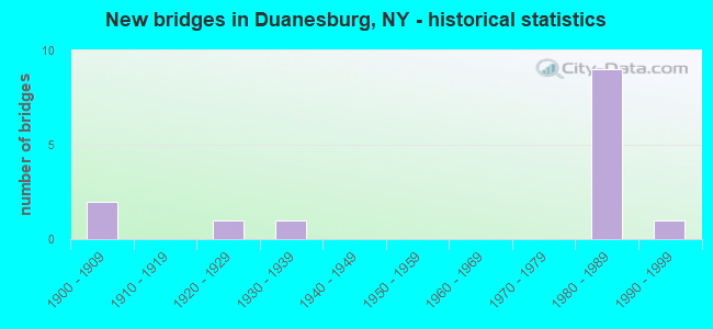
- New bridges - historical statistics
- 21900-1909
- 11920-1929
- 11930-1939
- 91980-1989
- 11990-1999

- Reconstructed bridges - Historical Statistics
- 11970-1979
- 01980-1989
- 01990-1999
- 12000-2009


- Bridge Condition - Deck
- 14.3%Very good
- 57.1%Satisfactory
- 28.6%Fair

- Bridge Condition - Superstructure
- 25.0%Very good
- 25.0%Good
- 50.0%Fair

- Bridge Condition - Substructure
- 25.0%Very good
- 12.5%Good
- 25.0%Satisfactory
- 37.5%Fair

- Bridge Condition - Channel
- 50.0%Satisfactory
- 50.0%Fair
Find on map >> Show street view
Structure Number: 100415, Location: .8 MI SW JCT US 20 & SH 7 (Lat: 42.754664, Lng: -74.145964), Route carried "on" structure: State highway 7, Year Built: 1990, Status: Open, Structure Length: 4.82m (15.81ft), Average Daily Traffic: 2,214 (year 2020), Truck Traffic: 7%, Average Future Daily Traffic: 2,309 (year 2040), Design Load: HS 20, Features Intersected: SMS Rail Road
Minimum Vertical Clearance: 30+ m (98+ ft), Kilometerpoint: 11.311, Lanes on structure: 2, Base Highway Network: Yes, Owner: State Highway Agency, Approaching Roadway Width: 9.8m (32.2ft), Skew: 4 degrees, Material/Design: Steel continuous, Design/Construction: Stringer/Multi-beam, Number Of Spans In Main Unit: 3, Length of Maximum Span: 22.5m (73.8ft), Curb-To-Curb Width: 9.5m (31.2ft), Out-to-Out Width: 10.5m (34.4ft)
Condition: Deck: Very good, Superstructure: Very good, Substructure: Very good, Operating Rating: 59.0 metric tons, Method Used To Determine Operating Rating: Load Factor (LF), Inventory Rating: 32.7 metric tons, Method Used To Determine Inventory Rating: Load Factor (LF), Structural Evaluation: Equal to present desirable criteria, Deck Geometry: Meets minimum limits, Underclear: Better than present minimum criteria, Approach Roadway Alignment: Equal to present desirable criteria, Length Of Structure Improvement: 4.81m (15.78ft), Designated Inspection Frequency: Every 24 months, Inspection Date: September 2021, Bridge Improvement Cost: $1,354,000, Roadway Improvement Cost: $793,000, Total Project Cost: $2,147,000 ( Estimate for 2021), Deck Structure Type: Concrete Cast-file-Place, Wearing Surface/Protective System: Wearing Surface: Integral Concrete, Deck Protection: Epoxy Coated Reinforcing
Find on map >> Show street view
Structure Number: 101594, Location: 0.2 MI NW JCT RTS 7 & 20 (Lat: 42.761917, Lng: -74.137917), Route carried "on" structure: US 20, Year Built: 1929, Status: Open, Structure Length: 0.91m (2.99ft), Average Daily Traffic: 4,615 (year 2018), Truck Traffic: 6%, Average Future Daily Traffic: 5,170 (year 2040), Features Intersected: NORMANS KILL
Minimum Vertical Clearance: 30+ m (98+ ft), Kilometerpoint: 9.879, Lanes on structure: 2, Base Highway Network: Yes, Owner: State Highway Agency, Approaching Roadway Width: 10.4m (34.1ft), Material/Design: Concrete, Design/Construction: Arch - Deck, Number Of Spans In Main Unit: 1, Length of Maximum Span: 8.8m (28.9ft), Curb-To-Curb Width: 10.6m (34.8ft), Out-to-Out Width: 11.9m (39.0ft)
Condition: Superstructure: Fair, Substructure: Satisfactory, Channel: Fair, Operating Rating: 47.3 metric tons, Method Used To Determine Operating Rating: Field evaluation and documented engineering judgment, Inventory Rating: 19.5 metric tons, Method Used To Determine Inventory Rating: Field evaluation and documented engineering judgment, Structural Evaluation: Somewhat better than minimum adequacy, Deck Geometry: Somewhat better than minimum adequacy, Waterway Adequacy: Superior to present desirable criteria, Approach Roadway Alignment: Equal to present desirable criteria, Length Of Structure Improvement: 0.91m (2.99ft), Designated Inspection Frequency: Every 24 months, Inspection Date: June 2020, Bridge Improvement Cost: $207,000, Roadway Improvement Cost: $121,000, Total Project Cost: $329,000 ( Estimate for 2021), Wearing Surface/Protective System: Wearing Surface: Bituminous
Find on map >> Show street view
Structure Number: 1070731, Location: 1.2 MI W JCT US 20 & I88 (Lat: 42.753808, Lng: -74.144569), Route carried "on" structure: Interstate 88, Year Built: 1981, Status: Open, Structure Length: 6.00m (19.69ft), Average Daily Traffic: 7,071 (year 2005), Truck Traffic: 21%, Average Future Daily Traffic: 15,821 (year 2031), Design Load: HS 20, Features Intersected: DELAWARE & HUDSON
Minimum Vertical Clearance: 30+ m (98+ ft), Kilometerpoint: 11.617, Lanes on structure: 3, Base Highway Network: Yes, Owner: State Highway Agency, Approaching Roadway Width: 14.0m (45.9ft), Skew: 2 degrees, Material/Design: Steel continuous, Design/Construction: Stringer/Multi-beam, Number Of Spans In Main Unit: 3, Length of Maximum Span: 23.4m (76.8ft), Curb-To-Curb Width: 13.7m (44.9ft), Out-to-Out Width: 14.7m (48.2ft)
Condition: Deck: Fair, Superstructure: Good, Substructure: Good, Operating Rating: 42.4 metric tons, Method Used To Determine Operating Rating: Load and Resistance Factor Rating (LRFR) rating reported by rating factor(RF) method using HL-93 loadings, Inventory Rating: 32.7 metric tons, Method Used To Determine Inventory Rating: Load and Resistance Factor Rating (LRFR) rating reported by rating factor(RF) method using HL-93 loadings, Structural Evaluation: Better than present minimum criteria, Deck Geometry: High priority of corrective action, Underclear: Superior to present desirable criteria, Approach Roadway Alignment: Equal to present desirable criteria, Length Of Structure Improvement: 6.00m (19.69ft), Designated Inspection Frequency: Every 24 months, Inspection Date: July 2020, Bridge Improvement Cost: $2,048,000, Roadway Improvement Cost: $1,199,000, Total Project Cost: $3,247,000 ( Estimate for 2021), Deck Structure Type: Concrete Cast-file-Place, Wearing Surface/Protective System: Wearing Surface: Bituminous, Membrane: Other, Deck Protection: Epoxy Coated Reinforcing
Find on map >> Show street view
Structure Number: 1070732, Location: 1.2 MI W JCT RTS 20 & I88 (Lat: 42.753556, Lng: -74.144331), Route carried "on" structure: Interstate 88, Year Built: 1981, Status: Open, Structure Length: 6.40m (21.00ft), Average Daily Traffic: 5,519 (year 2019), Truck Traffic: 17%, Average Future Daily Traffic: 6,573 (year 2040), Design Load: HS 20, Features Intersected: DELAWARE & HUDSON
Minimum Vertical Clearance: 30+ m (98+ ft), Kilometerpoint: 11.617, Lanes on structure: 2, Base Highway Network: Yes, Owner: State Highway Agency, Approaching Roadway Width: 12.8m (42.0ft), Skew: 2 degrees, Material/Design: Steel continuous, Design/Construction: Stringer/Multi-beam, Number Of Spans In Main Unit: 3, Length of Maximum Span: 24.6m (80.7ft), Curb-To-Curb Width: 12.5m (41.0ft), Out-to-Out Width: 13.4m (44.0ft)
Condition: Deck: Satisfactory, Superstructure: Good, Substructure: Very good, Operating Rating: 40.5 metric tons, Method Used To Determine Operating Rating: Load and Resistance Factor Rating (LRFR) rating reported by rating factor(RF) method using HL-93 loadings, Inventory Rating: 31.1 metric tons, Method Used To Determine Inventory Rating: Load and Resistance Factor Rating (LRFR) rating reported by rating factor(RF) method using HL-93 loadings, Structural Evaluation: Better than present minimum criteria, Deck Geometry: Better than present minimum criteria, Underclear: Superior to present desirable criteria, Approach Roadway Alignment: Equal to present desirable criteria, Length Of Structure Improvement: 6.40m (21.00ft), Designated Inspection Frequency: Every 24 months, Inspection Date: July 2020, Bridge Improvement Cost: $1,970,000, Roadway Improvement Cost: $1,154,000, Total Project Cost: $3,124,000 ( Estimate for 2021), Deck Structure Type: Concrete Cast-file-Place, Wearing Surface/Protective System: Wearing Surface: Bituminous, Deck Protection: Epoxy Coated Reinforcing
Find on map >> Show street view
Structure Number: 1070751, Location: 1.3 MI W JCT RTS 20 & I88 (Lat: 42.753514, Lng: -74.145781), Route carried "on" structure: Interstate 88, Year Built: 1981, Status: Open, Structure Length: 3.26m (10.70ft), Average Daily Traffic: 7,071 (year 2005), Truck Traffic: 21%, Design Load: HS 20, Features Intersected: WEAVER ROAD
Minimum Vertical Clearance: 30+ m (98+ ft), Kilometerpoint: 11.520, Lanes on structure: 3, Lanes under structure: 2, Base Highway Network: Yes, Owner: State Highway Agency, Approaching Roadway Width: 14.0m (45.9ft), Material/Design: Prestressed concrete, Design/Construction: Box Beam or Girders - Multiple, Number Of Spans In Main Unit: 1, Length of Maximum Span: 31.3m (102.7ft), Curb-To-Curb Width: 13.7m (44.9ft), Out-to-Out Width: 15.0m (49.2ft)
Condition: Deck: Satisfactory, Superstructure: Fair, Substructure: Fair, Operating Rating: 86.2 metric tons, Method Used To Determine Operating Rating: Load Factor (LF), Inventory Rating: 33.6 metric tons, Method Used To Determine Inventory Rating: Load Factor (LF), Structural Evaluation: Somewhat better than minimum adequacy, Deck Geometry: High priority of corrective action, Underclear: High priority of corrective action, Approach Roadway Alignment: Equal to present desirable criteria, Length Of Structure Improvement: 3.26m (10.70ft), Designated Inspection Frequency: Every 24 months, Inspection Date: April 2020, Bridge Improvement Cost: $1,680,000, Roadway Improvement Cost: $984,000, Total Project Cost: $2,664,000 ( Estimate for 2021), Wearing Surface/Protective System: Wearing Surface: Bituminous
Find on map >> Show street view
Structure Number: 1070752, Location: 1.3 MI W JCT RTS 20 & I88 (Lat: 42.753239, Lng: -74.145656), Route carried "on" structure: Interstate 88, Year Built: 1981, Status: Open, Structure Length: 3.26m (10.70ft), Average Daily Traffic: 5,519 (year 2019), Truck Traffic: 17%, Average Future Daily Traffic: 6,573 (year 2040), Design Load: HS 20, Features Intersected: WEAVER ROAD
Minimum Vertical Clearance: 30+ m (98+ ft), Kilometerpoint: 11.520, Lanes on structure: 2, Lanes under structure: 2, Base Highway Network: Yes, Owner: State Highway Agency, Approaching Roadway Width: 13.1m (43.0ft), Material/Design: Prestressed concrete, Design/Construction: Box Beam or Girders - Multiple, Number Of Spans In Main Unit: 1, Length of Maximum Span: 31.3m (102.7ft), Curb-To-Curb Width: 12.5m (41.0ft), Out-to-Out Width: 13.7m (44.9ft)
Condition: Deck: Fair, Superstructure: Fair, Substructure: Fair, Operating Rating: 92.5 metric tons, Method Used To Determine Operating Rating: Load Factor (LF), Inventory Rating: 53.5 metric tons, Method Used To Determine Inventory Rating: Load Factor (LF), Structural Evaluation: Somewhat better than minimum adequacy, Deck Geometry: Better than present minimum criteria, Underclear: High priority of corrective action, Approach Roadway Alignment: Equal to present desirable criteria, Length Of Structure Improvement: 3.26m (10.70ft), Designated Inspection Frequency: Every 24 months, Inspection Date: April 2020, Bridge Improvement Cost: $1,503,000, Roadway Improvement Cost: $880,000, Total Project Cost: $2,383,000 ( Estimate for 2021), Wearing Surface/Protective System: Wearing Surface: Bituminous
Find on map >> Show street view
Structure Number: 107077, Location: JCT OF RTS 20 & I88 (Lat: 42.760233, Lng: -74.120000), Route carried "on" structure: US 20, Year Built: 1981, Year Reconstructed: 2012, Status: Open, Structure Length: 17.31m (56.79ft), Average Daily Traffic: 4,449 (year 2020), Truck Traffic: 8%, Average Future Daily Traffic: 4,984 (year 2040), Design Load: HS 20, Features Intersected: 88I 88I16081086 EB, RTE
Minimum Vertical Clearance: 30+ m (98+ ft), Kilometerpoint: 11.311, Lanes on structure: 2, Lanes under structure: 5, Base Highway Network: Yes, Owner: State Highway Agency, Approaching Roadway Width: 15.5m (50.9ft), Material/Design: Steel continuous, Design/Construction: Stringer/Multi-beam, Number Of Spans In Main Unit: 2, Length of Maximum Span: 85.6m (280.8ft), Curb-To-Curb Width: 15.5m (50.9ft), Out-to-Out Width: 16.5m (54.1ft)
Condition: Deck: Satisfactory, Superstructure: Fair, Substructure: Satisfactory, Inventory Rating: 64.4 metric tons, Method Used To Determine Inventory Rating: Load Factor (LF), Structural Evaluation: Somewhat better than minimum adequacy, Deck Geometry: Superior to present desirable criteria, Underclear: High priority of corrective action, Approach Roadway Alignment: Equal to present desirable criteria, Length Of Structure Improvement: 17.31m (56.79ft), Designated Inspection Frequency: Every 24 months, Inspection Date: November 2021, Bridge Improvement Cost: $6,032,000, Roadway Improvement Cost: $3,533,000, Total Project Cost: $9,565,000 ( Estimate for 2021), Deck Structure Type: Concrete Cast-file-Place, Wearing Surface/Protective System: Wearing Surface: Monolithic Concrete, Deck Protection: Epoxy Coated Reinforcing
Find on map >> Show street view
Structure Number: 330489, Location: .4 MI N OF DUANESBURG (Lat: 42.767350, Lng: -74.127767), Route carried "on" structure: County highway , Year Built: 1907, Year Reconstructed: 1984, Status: Open, Structure Length: 1.83m (6.00ft), Average Daily Traffic: 285 (year 2014), Truck Traffic: 3%, Average Future Daily Traffic: 399 (year 2034), Design Load: HS 20, Features Intersected: NORMANS KILL, Facility Carried by Structure: DEPOT ROAD
Minimum Vertical Clearance: 30+ m (98+ ft), Kilometerpoint: 0.837, Lanes on structure: 2, Owner: County Highway Agency, Approaching Roadway Width: 5.5m (18.0ft), Material/Design: Prestressed concrete, Design/Construction: Box Beam or Girders - Multiple, Number Of Spans In Main Unit: 1, Length of Maximum Span: 17.3m (56.8ft), Curb-To-Curb Width: 8.0m (26.2ft), Out-to-Out Width: 8.7m (28.5ft)
Condition: Deck: Satisfactory, Superstructure: Very good, Substructure: Fair, Channel: Satisfactory, Operating Rating: 36.0 metric tons, Method Used To Determine Operating Rating: Load and Resistance Factor Rating (LRFR) rating reported by rating factor(RF) method using HL-93 loadings, Inventory Rating: 18.5 metric tons, Method Used To Determine Inventory Rating: Load and Resistance Factor Rating (LRFR) rating reported by rating factor(RF) method using HL-93 loadings, Structural Evaluation: Somewhat better than minimum adequacy, Deck Geometry: Somewhat better than minimum adequacy, Waterway Adequacy: Meets minimum limits, Approach Roadway Alignment: Meets minimum limits, Length Of Structure Improvement: 1.82m (5.97ft), Designated Inspection Frequency: Every 24 months, Inspection Date: May 2021, Bridge Improvement Cost: $541,000, Roadway Improvement Cost: $317,000, Total Project Cost: $857,000 ( Estimate for 2021), Deck Structure Type: Concrete Cast-file-Place, Wearing Surface/Protective System: Wearing Surface: Bituminous, Membrane: Other
Find on map >> Show street view
Structure Number: 10707, Location: .4 MI.E JCT RTS 20 I88 (Lat: 42.762528, Lng: -74.114492), Route carried "under" structure: Interstate 88, Year Built: 1981, Structure Length: 0. m, Average Daily Traffic: 100 (year 2021), Features Intersected: 88I 88I16081088-WB, RTE, Facility Carried by Structure: RTE 915
Minimum Vertical Clearance: 5.69m (18.67ft), Kilometerpoint: 14.384, Lanes on structure: 4, Lanes under structure: 2, Material/Design: Steel continuous, Design/Construction: Stringer/Multi-beam, Length of Maximum Span: 45.4m (149.0ft)
Find on map >> Show street view
Structure Number: 1070751, Location: 1.3 MI W JCT RTS 20 & I88 (Lat: 42.753514, Lng: -74.145781), Route carried "under" structure: Other road , Year Built: 1981, Structure Length: 0. m, Truck Traffic: 6%, Features Intersected: WEAVER ROAD, Facility Carried by Structure: RTE I88
Minimum Vertical Clearance: 5.64m (18.50ft), Kilometerpoint: 0.000, Lanes on structure: 3, Lanes under structure: 2, Material/Design: Prestressed concrete, Design/Construction: Box Beam or Girders - Multiple, Length of Maximum Span: 31.3m (102.7ft)
Find on map >> Show street view
Structure Number: 1070752, Location: 1.3 MI W JCT RTS 20 & I88 (Lat: 42.753239, Lng: -74.145656), Route carried "under" structure: Other road , Year Built: 1981, Structure Length: 0. m, Truck Traffic: 6%, Features Intersected: WEAVER ROAD, Facility Carried by Structure: RTE I88
Minimum Vertical Clearance: 5.77m (18.93ft), Kilometerpoint: 0.129, Lanes on structure: 2, Lanes under structure: 2, Material/Design: Prestressed concrete, Design/Construction: Box Beam or Girders - Multiple, Length of Maximum Span: 31.3m (102.7ft)
Find on map >> Show street view
Structure Number: 107077, Location: JCT OF RTS 20 & I88 (Lat: 42.760233, Lng: -74.120000), Route carried "under" structure: Interstate 88, Year Built: 1981, Structure Length: 0. m, Average Daily Traffic: 100 (year 2021), Features Intersected: 88I 88I16081086 EB, RTE, Facility Carried by Structure: RTE 20
Minimum Vertical Clearance: 5.69m (18.67ft), Kilometerpoint: 13.918, Lanes on structure: 2, Lanes under structure: 3, Material/Design: Steel continuous, Design/Construction: Stringer/Multi-beam, Length of Maximum Span: 85.6m (280.8ft)
Find on map >> Show street view
Structure Number: 701593, Location: 0.7 MI NW JCT RTES 7 & 20 (Lat: 42.764572, Lng: -74.144853), Route carried "under" structure: US 20, Year Built: 1937, Structure Length: 0. m, Average Daily Traffic: 5,660 (year 2000), Features Intersected: RTE 20, Facility Carried by Structure: DELAWARE & HUDSON
Minimum Vertical Clearance: 4.39m (14.40ft), Kilometerpoint: 9.300, Lanes under structure: 2, Material/Design: Steel, Design/Construction: Girder and Floorbeam System, Length of Maximum Span: 34.7m (113.8ft)
Find on map >> Show street view
Structure Number: 730504, Location: .5 MI N OF DUANESBURG (Lat: 42.767508, Lng: -74.127914), Route carried "under" structure: County highway , Year Built: 1907, Structure Length: 0. m, Average Daily Traffic: 285 (year 2014), Truck Traffic: 3%, Features Intersected: COUNTY ROAD 123, Facility Carried by Structure: DELAWARE & HUDSON
Minimum Vertical Clearance: 3.40m (11.15ft), Kilometerpoint: 0.837, Lanes under structure: 2, Material/Design: Steel, Design/Construction: Girder and Floorbeam System, Length of Maximum Span: 11.2m (36.7ft)