Bridge Statistics for Dubois, Idaho (ID)
Condition, Traffic, Stress, Structural Evaluation, Project Costs
- National Bridge Inventory (NBI) Statistics
- 17Number of bridges
- 138ft / 42.3mTotal length
- $5,824,000Total costs
- 55,390Total average daily traffic
- 10,197Total average daily truck traffic
- National Bridge Inventory (NBI) Registered Bridges for Dubois
- No street view available for this location
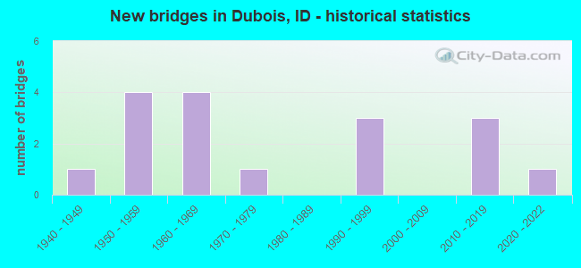
- New bridges - historical statistics
- 11940-1949
- 41950-1959
- 41960-1969
- 11970-1979
- 31990-1999
- 32010-2019
- 12020-2022

- Reconstructed bridges - Historical Statistics
- 11950-1959
- 01960-1969
- 01970-1979
- 21980-1989


- Bridge Condition - Deck
- 6.7%Excellent
- 6.7%Very good
- 20.0%Good
- 60.0%Satisfactory
- 6.7%Fair

- Bridge Condition - Superstructure
- 6.7%Excellent
- 13.3%Very good
- 26.7%Good
- 40.0%Satisfactory
- 6.7%Fair
- 6.7%Poor

- Bridge Condition - Substructure
- 6.7%Excellent
- 13.3%Very good
- 6.7%Good
- 60.0%Satisfactory
- 13.3%Fair

- Bridge Condition - Channel
- 27.3%Excellent
- 18.2%Very good
- 27.3%Good
- 18.2%Satisfactory
- 9.1%Fair
Find on map >> Show street view
Structure Number: 1092, Location: 2.9 W. AMERICAN FALLS (Lat: 42.748972, Lng: -112.879694), Route carried "on" structure: Business City street 86, Year Built: 1959, Year Reconstructed: 1985, Status: Open, Structure Length: 7.47m (24.51ft), Average Daily Traffic: 1,300 (year 2019), Truck Traffic: 15%, Average Future Daily Traffic: 1,950 (year 2039), Design Load: HS 25 or greater, Features Intersected: I 86 EB-WB;ROCKLAND IC
Minimum Vertical Clearance: 30+ m (98+ ft), Kilometerpoint: 0.027, Lanes on structure: 2, Lanes under structure: 4, Owner: State Highway Agency, Approaching Roadway Width: 9.1m (29.9ft), Skew: 3 degrees, Material/Design: Prestressed concrete, Design/Construction: Box Beam or Girders - Multiple, Number Of Spans In Main Unit: 5, Length of Maximum Span: 17.7m (58.1ft), Curb-To-Curb Width: 8.8m (28.9ft), Out-to-Out Width: 9.8m (32.2ft)
Condition: Deck: Satisfactory, Superstructure: Poor, Substructure: Fair, Operating Rating: 68.0 metric tons, Method Used To Determine Operating Rating: Load Factor (LF), Inventory Rating: 26.3 metric tons, Method Used To Determine Inventory Rating: Load Factor (LF), Structural Evaluation: Meets minimum limits, Deck Geometry: Somewhat better than minimum adequacy, Underclear: High priority of replacement, Approach Roadway Alignment: Equal to present desirable criteria, Length Of Structure Improvement: 8.96m (29.40ft), Designated Inspection Frequency: Every 12 months, Inspection Date: September 2021, Bridge Improvement Cost: $2,037,000, Roadway Improvement Cost: $204,000, Total Project Cost: $3,056,000 ( Estimate for 2015), Deck Structure Type: Concrete Precast Panels, Wearing Surface/Protective System: Wearing Surface: Bituminous, Deck Protection: Epoxy Coated Reinforcing
Find on map >> Show street view
Structure Number: 1192, Location: 3.5 S. DUBOIS (Lat: 44.124222, Lng: -112.236194), Route carried "on" structure: Interstate 15, Year Built: 1965, Year Reconstructed: 1989, Status: Open, Structure Length: 0.85m (2.79ft), Average Daily Traffic: 3,400 (year 2019), Truck Traffic: 32%, Average Future Daily Traffic: 5,100 (year 2039), Design Load: HS 20, Features Intersected: BEAVER CREEK;S.DUBOIS BR
Minimum Vertical Clearance: 30+ m (98+ ft), Kilometerpoint: 263.025, Lanes on structure: 4, Base Highway Network: Yes, Owner: State Highway Agency, Approaching Roadway Width: 25.0m (82.0ft), Skew: 13 degrees, Material/Design: Concrete, Design/Construction: Frame, Number Of Spans In Main Unit: 1, Length of Maximum Span: 8.5m (27.9ft), Curb or Sidewalk Widths: Left: 0.3m (1.0ft), Right: 0.3m (1.0ft), Curb-To-Curb Width: 61.0m (200.1ft), Out-to-Out Width: 61.6m (202.1ft)
Condition: Deck: Satisfactory, Superstructure: Satisfactory, Substructure: Satisfactory, Channel: Good, Operating Rating: 82.6 metric tons, Method Used To Determine Operating Rating: Load Factor (LF), Inventory Rating: 49.0 metric tons, Method Used To Determine Inventory Rating: Load Factor (LF), Structural Evaluation: Equal to present minimum criteria, Deck Geometry: Superior to present desirable criteria, Waterway Adequacy: Equal to present desirable criteria, Approach Roadway Alignment: Equal to present desirable criteria, Designated Inspection Frequency: Every 48 months, Inspection Date: June 2019, Deck Structure Type: Concrete Cast-file-Place, Wearing Surface/Protective System: Wearing Surface: Bituminous
Find on map >> Show street view
Structure Number: 1193, Location: 3.5 N. DUBOIS (Lat: 44.228389, Lng: -112.231389), Route carried "on" structure: Interstate 15, Year Built: 1965, Status: Open, Structure Length: 1.92m (6.30ft), Average Daily Traffic: 1,700 (year 2019), Truck Traffic: 38%, Average Future Daily Traffic: 2,550 (year 2039), Design Load: HS 20, Features Intersected: BEAVER CREEK
Minimum Vertical Clearance: 30+ m (98+ ft), Kilometerpoint: 274.702, Lanes on structure: 2, Base Highway Network: Yes, Owner: State Highway Agency, Approaching Roadway Width: 13.4m (44.0ft), Skew: 1 degrees, Material/Design: Prestressed concrete, Design/Construction: Stringer/Multi-beam, Number Of Spans In Main Unit: 1, Length of Maximum Span: 18.3m (60.0ft), Curb-To-Curb Width: 13.4m (44.0ft), Out-to-Out Width: 14.0m (45.9ft)
Condition: Deck: Satisfactory, Superstructure: Good, Substructure: Satisfactory, Channel: Excellent, Operating Rating: 64.4 metric tons, Method Used To Determine Operating Rating: Load Factor (LF), Inventory Rating: 39.0 metric tons, Method Used To Determine Inventory Rating: Load Factor (LF), Structural Evaluation: Equal to present minimum criteria, Deck Geometry: Superior to present desirable criteria, Waterway Adequacy: Superior to present desirable criteria, Approach Roadway Alignment: Equal to present desirable criteria, Designated Inspection Frequency: Every 48 months, Inspection Date: June 2019, Deck Structure Type: Concrete Cast-file-Place, Wearing Surface/Protective System: Wearing Surface: Monolithic Concrete
Find on map >> Show street view
Structure Number: 11931, Location: 3.5 N. DUBOIS (Lat: 44.228722, Lng: -112.231722), Route carried "on" structure: Interstate 15, Year Built: 1991, Status: Open, Structure Length: 2.01m (6.59ft), Average Daily Traffic: 1,700 (year 2019), Truck Traffic: 32%, Average Future Daily Traffic: 2,550 (year 2039), Design Load: HS 25 or greater, Features Intersected: BEAVER CREEK
Minimum Vertical Clearance: 30+ m (98+ ft), Kilometerpoint: 274.704, Lanes on structure: 2, Base Highway Network: Yes, Owner: State Highway Agency, Approaching Roadway Width: 12.8m (42.0ft), Material/Design: Prestressed concrete, Design/Construction: Stringer/Multi-beam, Number Of Spans In Main Unit: 1, Length of Maximum Span: 19.5m (64.0ft), Curb-To-Curb Width: 12.4m (40.7ft), Out-to-Out Width: 13.3m (43.6ft)
Condition: Deck: Satisfactory, Superstructure: Good, Substructure: Satisfactory, Channel: Excellent, Operating Rating: 71.7 metric tons, Method Used To Determine Operating Rating: Load Factor (LF), Inventory Rating: 42.6 metric tons, Method Used To Determine Inventory Rating: Load Factor (LF), Structural Evaluation: Equal to present minimum criteria, Deck Geometry: Better than present minimum criteria, Waterway Adequacy: Superior to present desirable criteria, Approach Roadway Alignment: Equal to present desirable criteria, Designated Inspection Frequency: Every 48 months, Inspection Date: June 2019, Deck Structure Type: Concrete Cast-file-Place, Wearing Surface/Protective System: Wearing Surface: Low Slump Concrete, Deck Protection: Epoxy Coated Reinforcing
Find on map >> Show street view
Structure Number: 12991, Location: IN DUBOIS (Lat: 44.176361, Lng: -112.240889), Route carried "on" structure: State highway 22, Year Built: 2012, Status: Open, Structure Length: 7.07m (23.20ft), Average Daily Traffic: 1,300 (year 2019), Truck Traffic: 6%, Average Future Daily Traffic: 1,950 (year 2039), Design Load: HL 93, Features Intersected: I 15 NB-SB; DUBOIS IC
Minimum Vertical Clearance: 30+ m (98+ ft), Kilometerpoint: 110.247, Lanes on structure: 2, Lanes under structure: 4, Owner: State Highway Agency, Approaching Roadway Width: 16.5m (54.1ft), Material/Design: Steel continuous, Design/Construction: Stringer/Multi-beam, Number Of Spans In Main Unit: 2, Length of Maximum Span: 35.1m (115.2ft), Curb-To-Curb Width: 16.5m (54.1ft), Out-to-Out Width: 17.1m (56.1ft)
Condition: Deck: Good, Superstructure: Very good, Substructure: Very good, Operating Rating: 43.4 metric tons, Method Used To Determine Operating Rating: Load and Resistance Factor Rating (LRFR) rating reported by rating factor(RF) method using HL-93 loadings, Inventory Rating: 33.4 metric tons, Method Used To Determine Inventory Rating: Load and Resistance Factor Rating (LRFR) rating reported by rating factor(RF) method using HL-93 loadings, Structural Evaluation: Equal to present desirable criteria, Deck Geometry: Superior to present desirable criteria, Underclear: High priority of corrective action, Approach Roadway Alignment: Equal to present desirable criteria, Designated Inspection Frequency: Every 48 months, Inspection Date: May 2020, Deck Structure Type: Concrete Cast-file-Place, Wearing Surface/Protective System: Wearing Surface: Monolithic Concrete, Deck Protection: Epoxy Coated Reinforcing
Find on map >> Show street view
Structure Number: 135, Location: IN NAMPA (Lat: 43.583333, Lng: -116.556111), Route carried "on" structure: Business Interstate 84, Year Built: 1951, Year Reconstructed: 1955, Status: Open, Structure Length: 0.79m (2.59ft), Average Daily Traffic: 22,500 (year 2019), Truck Traffic: 4%, Average Future Daily Traffic: 33,750 (year 2039), Design Load: HS 20, Features Intersected: INDIAN CREEK
Minimum Vertical Clearance: 30+ m (98+ ft), Kilometerpoint: 95.221, Lanes on structure: 5, Base Highway Network: Yes (Inventory Route: IB0, Subroute: 3), Owner: State Highway Agency, Approaching Roadway Width: 18.9m (62.0ft), Material/Design: Steel, Design/Construction: Stringer/Multi-beam, Number Of Spans In Main Unit: 1, Length of Maximum Span: 7.6m (24.9ft), Curb or Sidewalk Widths: Left: 1.8m (5.9ft), Right: 1.8m (5.9ft), Curb-To-Curb Width: 18.7m (61.4ft), Out-to-Out Width: 23.2m (76.1ft)
Condition: Deck: Satisfactory, Superstructure: Satisfactory, Substructure: Satisfactory, Channel: Satisfactory, Operating Rating: 71.7 metric tons, Method Used To Determine Operating Rating: Load Factor (LF), Inventory Rating: 42.6 metric tons, Method Used To Determine Inventory Rating: Load Factor (LF), Structural Evaluation: Equal to present minimum criteria, Deck Geometry: High priority of corrective action, Waterway Adequacy: Equal to present desirable criteria, Approach Roadway Alignment: Equal to present desirable criteria, Designated Inspection Frequency: Every 48 months, Underwater Inspection Frequency: Every 60 months, Inspection Date: January 2021, Underwater Inspection Date: August 2019, Deck Structure Type: Concrete Cast-file-Place, Wearing Surface/Protective System: Wearing Surface: Bituminous
Find on map >> Show street view
Structure Number: 151, Location: 8.9 W. CAREY (Lat: 43.317361, Lng: -114.105611), Route carried "on" structure: US 20, Year Built: 1979, Status: Open, Structure Length: 3.14m (10.30ft), Average Daily Traffic: 1,800 (year 2019), Truck Traffic: 18%, Average Future Daily Traffic: 2,700 (year 2039), Design Load: HS 20, Features Intersected: SILVER CREEK
Minimum Vertical Clearance: 30+ m (98+ ft), Kilometerpoint: 301.183, Lanes on structure: 2, Base Highway Network: Yes (Inventory Route: US0, Subroute: 1), Owner: State Highway Agency, Approaching Roadway Width: 10.4m (34.1ft), Skew: 3 degrees, Material/Design: Prestressed concrete, Design/Construction: Box Beam or Girders - Multiple, Number Of Spans In Main Unit: 3, Length of Maximum Span: 10.7m (35.1ft), Curb-To-Curb Width: 11.3m (37.1ft), Out-to-Out Width: 12.2m (40.0ft)
Condition: Deck: Satisfactory, Superstructure: Fair, Substructure: Satisfactory, Channel: Very good, Operating Rating: 78.0 metric tons, Method Used To Determine Operating Rating: Load Factor (LF), Inventory Rating: 34.5 metric tons, Method Used To Determine Inventory Rating: Load Factor (LF), Structural Evaluation: Somewhat better than minimum adequacy, Deck Geometry: Equal to present minimum criteria, Waterway Adequacy: Equal to present desirable criteria, Approach Roadway Alignment: Equal to present desirable criteria, Length Of Structure Improvement: 4.08m (13.39ft), Designated Inspection Frequency: Every 24 months, Underwater Inspection Frequency: Every 60 months, Inspection Date: May 2021, Underwater Inspection Date: August 2019, Bridge Improvement Cost: $884,000, Roadway Improvement Cost: $88,000, Total Project Cost: $1,326,000 ( Estimate for 2019), Deck Structure Type: Concrete Cast-file-Place, Wearing Surface/Protective System: Wearing Surface: Latex Concrete, Deck Protection: Epoxy Coated Reinforcing
Find on map >> Show street view
Structure Number: 16255, Location: 18.5 W. BURLEY (Lat: 42.574350, Lng: -114.148200), Route carried "on" structure: Interstate 84, Year Built: 1966, Status: Open, Structure Length: 3.57m (11.71ft), Average Daily Traffic: 10,750 (year 2019), Truck Traffic: 32%, Average Future Daily Traffic: 16,125 (year 2039), Design Load: HS 20, Features Intersected: STC2744;MURTAUGH RD GS
Minimum Vertical Clearance: 30+ m (98+ ft), Kilometerpoint: 304.896, Lanes on structure: 2, Lanes under structure: 2, Base Highway Network: Yes (Inventory Route: I, Subroute: 2), Owner: State Highway Agency, Approaching Roadway Width: 11.6m (38.1ft), Skew: 1 degrees, Material/Design: Concrete, Design/Construction: Stringer/Multi-beam, Number Of Spans In Main Unit: 3, Length of Maximum Span: 11.6m (38.1ft), Curb-To-Curb Width: 11.4m (37.4ft), Out-to-Out Width: 12.0m (39.4ft)
Condition: Deck: Satisfactory, Superstructure: Satisfactory, Substructure: Satisfactory, Operating Rating: 56.2 metric tons, Method Used To Determine Operating Rating: Load Factor (LF), Inventory Rating: 33.6 metric tons, Method Used To Determine Inventory Rating: Load Factor (LF), Structural Evaluation: Equal to present minimum criteria, Deck Geometry: Somewhat better than minimum adequacy, Underclear: Meets minimum limits, Approach Roadway Alignment: Equal to present desirable criteria, Designated Inspection Frequency: Every 48 months, Inspection Date: August 2020, Deck Structure Type: Concrete Cast-file-Place, Wearing Surface/Protective System: Wearing Surface: Latex Concrete
Find on map >> Show street view
Structure Number: 208, Location: 3.8 S. 1.9 E. IDAHO FALLS (Lat: 43.436333, Lng: -112.003833), Route carried "on" structure: County highway 6705, Year Built: 1966, Status: Open, Structure Length: 1.34m (4.40ft), Average Daily Traffic: 2,200 (year 2019), Truck Traffic: 5%, Average Future Daily Traffic: 3,300 (year 2039), Design Load: H 20, Features Intersected: W. BRANCH SAND CREEK
Minimum Vertical Clearance: 30+ m (98+ ft), Kilometerpoint: 2.929, Lanes on structure: 2, Owner: City or Municipal Highway Agency, Approaching Roadway Width: 9.1m (29.9ft), Skew: 3 degrees, Material/Design: Prestressed concrete, Design/Construction: Stringer/Multi-beam, Number Of Spans In Main Unit: 1, Length of Maximum Span: 12.8m (42.0ft), Curb or Sidewalk Widths: Left: 0.2m (0.7ft), Right: 0.2m (0.7ft), Curb-To-Curb Width: 10.5m (34.4ft), Out-to-Out Width: 11.9m (39.0ft)
Condition: Deck: Satisfactory, Superstructure: Satisfactory, Substructure: Satisfactory, Channel: Fair, Operating Rating: 27.2 metric tons, Method Used To Determine Operating Rating: Field evaluation and documented engineering judgment, Inventory Rating: 16.3 metric tons, Method Used To Determine Inventory Rating: Field evaluation and documented engineering judgment, Structural Evaluation: Meets minimum limits, Deck Geometry: Somewhat better than minimum adequacy, Waterway Adequacy: Equal to present desirable criteria, Approach Roadway Alignment: Equal to present desirable criteria, Length Of Structure Improvement: 1.34m (4.40ft), Designated Inspection Frequency: Every 24 months, Inspection Date: April 2020, Bridge Improvement Cost: $464,000, Roadway Improvement Cost: $46,000, Total Project Cost: $696,000 ( Estimate for 2020), Deck Structure Type: Concrete Cast-file-Place, Wearing Surface/Protective System: Wearing Surface: Bituminous
Find on map >> Show street view
Structure Number: 21165, Location: IN DUBOIS;MAIN ST (Lat: 44.176250, Lng: -112.228944), Route carried "on" structure: County highway 6862, Year Built: 1953, Status: Open, Structure Length: 0.67m (2.20ft), Average Daily Traffic: 750 (year 2019), Truck Traffic: 13%, Average Future Daily Traffic: 1,125 (year 2039), Design Load: HS 20, Features Intersected: BEAVER CREEK
Minimum Vertical Clearance: 30+ m (98+ ft), Kilometerpoint: 0.787, Lanes on structure: 2, Owner: City or Municipal Highway Agency, Approaching Roadway Width: 8.5m (27.9ft), Material/Design: Concrete, Design/Construction: Frame, Number Of Spans In Main Unit: 1, Length of Maximum Span: 6.7m (22.0ft), Curb or Sidewalk Widths: Left: 2.5m (8.2ft), Right: 2.4m (7.9ft), Curb-To-Curb Width: 17.8m (58.4ft), Out-to-Out Width: 18.3m (60.0ft)
Condition: Deck: Satisfactory, Superstructure: Satisfactory, Substructure: Fair, Channel: Satisfactory, Operating Rating: 52.6 metric tons, Method Used To Determine Operating Rating: Load Factor (LF), Inventory Rating: 31.8 metric tons, Method Used To Determine Inventory Rating: Load Factor (LF), Structural Evaluation: Somewhat better than minimum adequacy, Deck Geometry: Superior to present desirable criteria, Waterway Adequacy: Equal to present desirable criteria, Approach Roadway Alignment: Better than present minimum criteria, Designated Inspection Frequency: Every 24 months, Inspection Date: July 2020, Deck Structure Type: Concrete Cast-file-Place, Wearing Surface/Protective System: Wearing Surface: Bituminous
Find on map >> Show street view
Structure Number: 2245, Location: 1.0 N. 3.5 E. SHELLEY (Lat: 43.395694, Lng: -112.053833), Route carried "on" structure: County highway , Year Built: 1959, Status: Posted for load, Structure Length: 0.85m (2.79ft), Average Daily Traffic: 150 (year 2019), Truck Traffic: 13%, Average Future Daily Traffic: 225 (year 2039), Design Load: H 15, Features Intersected: LITTLE SAND CREEK, Facility Carried by Structure: COUNTRY CLUB;1400N
Minimum Vertical Clearance: 30+ m (98+ ft), Kilometerpoint: 168.387, Lanes on structure: 2, Owner: County Highway Agency, Approaching Roadway Width: 6.4m (21.0ft), Skew: 1 degrees, Material/Design: Prestressed concrete, Design/Construction: Channel Beam, Number Of Spans In Main Unit: 1, Length of Maximum Span: 8.2m (26.9ft), Curb or Sidewalk Widths: Left: 0.3m (1.0ft), Right: 0.3m (1.0ft), Curb-To-Curb Width: 7.3m (24.0ft), Out-to-Out Width: 8.0m (26.2ft)
Condition: Deck: Good, Superstructure: Good, Substructure: Satisfactory, Channel: Good, Operating Rating: 27.2 metric tons, Method Used To Determine Operating Rating: Field evaluation and documented engineering judgment, Inventory Rating: 16.3 metric tons, Method Used To Determine Inventory Rating: Field evaluation and documented engineering judgment, Structural Evaluation: Somewhat better than minimum adequacy, Deck Geometry: Somewhat better than minimum adequacy, Waterway Adequacy: Equal to present minimum criteria, Approach Roadway Alignment: Better than present minimum criteria, Bridge Posting: Required (Relationship of Operating Rating to Maximum Legal Load: 20.0 - 29.9% below), Length Of Structure Improvement: 1.28m (4.20ft), Designated Inspection Frequency: Every 24 months, Inspection Date: April 2020, Bridge Improvement Cost: $208,000, Roadway Improvement Cost: $21,000, Total Project Cost: $312,000 ( Estimate for 2020), Deck Structure Type: Concrete Precast Panels, Wearing Surface/Protective System: Wearing Surface: Bituminous
Find on map >> Show street view
Structure Number: 31571, Location: 4.8 N 0.2 W DUBOIS (Lat: 44.247500, Lng: -112.240694), Route carried "on" structure: County highway , Year Built: 2021, Status: Open, Structure Length: 2.32m (7.61ft), Average Daily Traffic: 80 (year 2021), Truck Traffic: 12%, Average Future Daily Traffic: 120 (year 2041), Design Load: HL 93, Features Intersected: BEAVER CREEK, Facility Carried by Structure: SHEEP FARM ROAD
Minimum Vertical Clearance: 30+ m (98+ ft), Kilometerpoint: 0.797, Lanes on structure: 2, Owner: County Highway Agency, Approaching Roadway Width: 7.9m (25.9ft), Material/Design: Prestressed concrete, Design/Construction: Stringer/Multi-beam, Number Of Spans In Main Unit: 1, Length of Maximum Span: 21.6m (70.9ft), Curb-To-Curb Width: 8.3m (27.2ft), Out-to-Out Width: 9.1m (29.9ft)
Condition: Deck: Excellent, Superstructure: Excellent, Substructure: Excellent, Channel: Very good, Operating Rating: 48.3 metric tons, Method Used To Determine Operating Rating: Load and Resistance Factor Rating (LRFR) rating reported by rating factor(RF) method using HL-93 loadings, Inventory Rating: 37.3 metric tons, Method Used To Determine Inventory Rating: Load and Resistance Factor Rating (LRFR) rating reported by rating factor(RF) method using HL-93 loadings, Structural Evaluation: Superior to present desirable criteria, Deck Geometry: Equal to present minimum criteria, Waterway Adequacy: Superior to present desirable criteria, Approach Roadway Alignment: Equal to present desirable criteria, Designated Inspection Frequency: Every 24 months, Inspection Date: June 2021, Deck Structure Type: Concrete Cast-file-Place, Wearing Surface/Protective System: Wearing Surface: Monolithic Concrete, Deck Protection: Epoxy Coated Reinforcing
Find on map >> Show street view
Structure Number: 31575, Location: IN DUBOIS (Lat: 44.173222, Lng: -112.228111), Route carried "on" structure: City street , Year Built: 1941, Status: Posted for load, Structure Length: 0.76m (2.49ft), Average Daily Traffic: 380 (year 2019), Truck Traffic: 29%, Average Future Daily Traffic: 570 (year 2039), Design Load: H 10, Features Intersected: BEAVER CREEK, Facility Carried by Structure: 2ND SOUTH ST
Minimum Vertical Clearance: 30+ m (98+ ft), Kilometerpoint: 174.229, Lanes on structure: 2, Owner: City or Municipal Highway Agency, Approaching Roadway Width: 7.3m (24.0ft), Material/Design: Steel, Design/Construction: Stringer/Multi-beam, Number Of Spans In Main Unit: 1, Length of Maximum Span: 7.0m (23.0ft), Curb or Sidewalk Widths: Left: 2.1m (6.9ft), Right: 0.0m, Curb-To-Curb Width: 7.4m (24.3ft), Out-to-Out Width: 10.0m (32.8ft)
Condition: Deck: Fair, Superstructure: Satisfactory, Substructure: Satisfactory, Channel: Good, Operating Rating: 31.8 metric tons, Method Used To Determine Operating Rating: Load Factor (LF), Inventory Rating: 19.1 metric tons, Method Used To Determine Inventory Rating: Load Factor (LF), Structural Evaluation: Somewhat better than minimum adequacy, Deck Geometry: Somewhat better than minimum adequacy, Waterway Adequacy: Equal to present minimum criteria, Approach Roadway Alignment: Equal to present desirable criteria, Bridge Posting: Required (Relationship of Operating Rating to Maximum Legal Load: 0.1 - 9.9% below), Length Of Structure Improvement: 1.37m (4.49ft), Designated Inspection Frequency: Every 24 months, Inspection Date: July 2020, Bridge Improvement Cost: $290,000, Roadway Improvement Cost: $29,000, Total Project Cost: $434,000 ( Estimate for 2018), Deck Structure Type: Concrete Cast-file-Place, Wearing Surface/Protective System: Wearing Surface: Bituminous
Find on map >> Show street view
Structure Number: 31591, Location: IN DUBOIS (Lat: 44.169611, Lng: -112.226639), Route carried "on" structure: City street , Year Built: 2013, Status: Open, Structure Length: 1.10m (3.61ft), Average Daily Traffic: 400 (year 2019), Truck Traffic: 10%, Average Future Daily Traffic: 600 (year 2039), Design Load: HL 93, Features Intersected: BEAVER CREEK, Facility Carried by Structure: 5TH SOUTH STREET
Minimum Vertical Clearance: 30+ m (98+ ft), Kilometerpoint: 161.651, Lanes on structure: 2, Owner: City or Municipal Highway Agency, Approaching Roadway Width: 6.7m (22.0ft), Skew: 2 degrees, Material/Design: Steel, Design/Construction: Stringer/Multi-beam, Number Of Spans In Main Unit: 1, Length of Maximum Span: 10.7m (35.1ft), Curb-To-Curb Width: 6.7m (22.0ft), Out-to-Out Width: 7.7m (25.3ft)
Condition: Deck: Very good, Superstructure: Very good, Substructure: Very good, Channel: Excellent, Operating Rating: 83.6 metric tons, Method Used To Determine Operating Rating: Load and Resistance Factor Rating (LRFR) rating reported by rating factor(RF) method using HL-93 loadings, Inventory Rating: 64.2 metric tons, Method Used To Determine Inventory Rating: Load and Resistance Factor Rating (LRFR) rating reported by rating factor(RF) method using HL-93 loadings, Structural Evaluation: Equal to present desirable criteria, Deck Geometry: Meets minimum limits, Waterway Adequacy: Equal to present desirable criteria, Approach Roadway Alignment: Equal to present minimum criteria, Designated Inspection Frequency: Every 48 months, Inspection Date: July 2020, Deck Structure Type: Concrete Cast-file-Place, Wearing Surface/Protective System: Wearing Surface: Bituminous, Deck Protection: Epoxy Coated Reinforcing
Find on map >> Show street view
Structure Number: 31616, Location: 5.0 N. DUBOIS (Lat: 44.247139, Lng: -112.228667), Route carried "on" structure: County highway , Year Built: 1990, Status: Open, Structure Length: 8.47m (27.79ft), Average Daily Traffic: 80 (year 2019), Truck Traffic: 13%, Average Future Daily Traffic: 120 (year 2039), Design Load: HS 25 or greater, Features Intersected: I 15;SHEEP FARM ROAD IC, Facility Carried by Structure: SHEEP FARM ROAD
Minimum Vertical Clearance: 30+ m (98+ ft), Kilometerpoint: 1.777, Lanes on structure: 2, Lanes under structure: 4, Owner: State Highway Agency, Approaching Roadway Width: 7.9m (25.9ft), Material/Design: Prestressed concrete, Design/Construction: Stringer/Multi-beam, Number Of Spans In Main Unit: 4, Length of Maximum Span: 31.1m (102.0ft), Curb-To-Curb Width: 8.1m (26.6ft), Out-to-Out Width: 9.1m (29.9ft)
Condition: Deck: Good, Superstructure: Good, Substructure: Good, Operating Rating: 90.6 metric tons, Method Used To Determine Operating Rating: Load Factor (LF), Inventory Rating: 46.3 metric tons, Method Used To Determine Inventory Rating: Load Factor (LF), Structural Evaluation: Better than present minimum criteria, Deck Geometry: Equal to present minimum criteria, Underclear: Better than present minimum criteria, Approach Roadway Alignment: Equal to present desirable criteria, Designated Inspection Frequency: Every 48 months, Inspection Date: June 2019, Deck Structure Type: Concrete Cast-file-Place, Wearing Surface/Protective System: Wearing Surface: Monolithic Concrete, Deck Protection: Epoxy Coated Reinforcing
Find on map >> Show street view
Structure Number: 12991, Location: IN DUBOIS (Lat: 44.176361, Lng: -112.240889), Route carried "under" structure: Interstate 15, Year Built: 2012, Structure Length: 0. m, Average Daily Traffic: 3,500 (year 2018), Truck Traffic: 37%, Features Intersected: I 15 NB-SB; DUBOIS IC, Facility Carried by Structure: SH 22
Minimum Vertical Clearance: 5.39m (17.68ft), Kilometerpoint: 268.822, Lanes on structure: 2, Lanes under structure: 4, Material/Design: Steel continuous, Design/Construction: Stringer/Multi-beam, Length of Maximum Span: 35.1m (115.2ft)
Find on map >> Show street view
Structure Number: 31616, Location: 5.0 N. DUBOIS (Lat: 44.247139, Lng: -112.228667), Route carried "under" structure: Interstate 15, Year Built: 1990, Structure Length: 0. m, Average Daily Traffic: 3,400 (year 2018), Truck Traffic: 38%, Features Intersected: I 15;SHEEP FARM ROAD IC, Facility Carried by Structure: SHEEP FARM ROAD
Minimum Vertical Clearance: 5.41m (17.75ft), Kilometerpoint: 276.765, Lanes on structure: 2, Lanes under structure: 4, Material/Design: Prestressed concrete, Design/Construction: Stringer/Multi-beam, Length of Maximum Span: 31.1m (102.0ft)