Bridge Statistics for Dubois, Wyoming (WY)
Condition, Traffic, Stress, Structural Evaluation, Project Costs
- National Bridge Inventory (NBI) Statistics
- 17Number of bridges
- 174ft / 53.2mTotal length
- $3,145,000Total costs
- 16,743Total average daily traffic
- 846Total average daily truck traffic
- 23,427Total future (year 2039) average daily traffic
- National Bridge Inventory (NBI) Registered Bridges for Dubois
- No street view available for this location
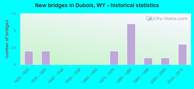
- New bridges - historical statistics
- 21920-1929
- 21930-1939
- 21970-1979
- 61980-1989
- 11990-1999
- 12000-2009
- 32010-2019
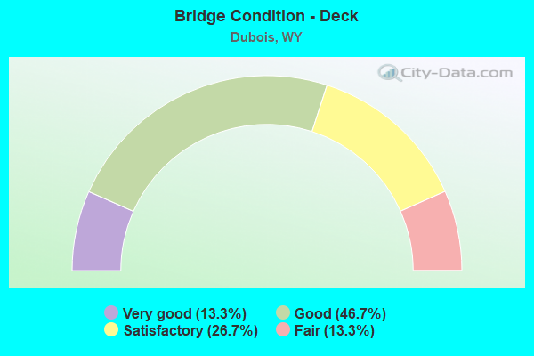
- Bridge Condition - Deck
- 13.3%Very good
- 46.7%Good
- 26.7%Satisfactory
- 13.3%Fair
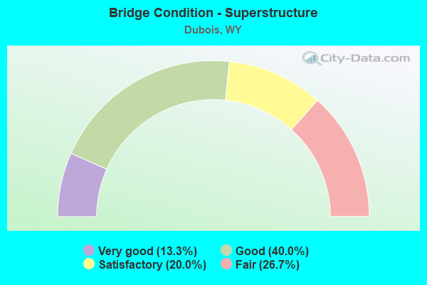
- Bridge Condition - Superstructure
- 13.3%Very good
- 40.0%Good
- 20.0%Satisfactory
- 26.7%Fair
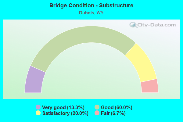
- Bridge Condition - Substructure
- 13.3%Very good
- 60.0%Good
- 20.0%Satisfactory
- 6.7%Fair
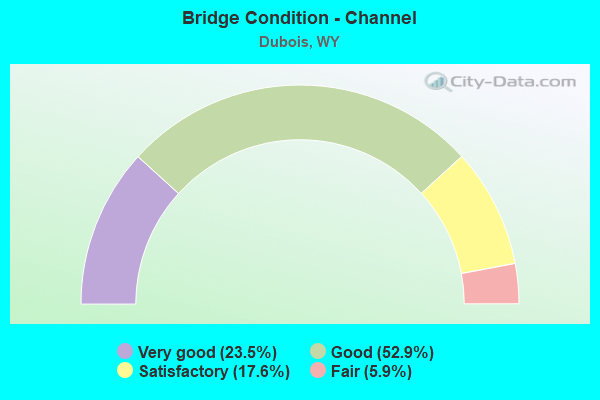
- Bridge Condition - Channel
- 23.5%Very good
- 52.9%Good
- 17.6%Satisfactory
- 5.9%Fair
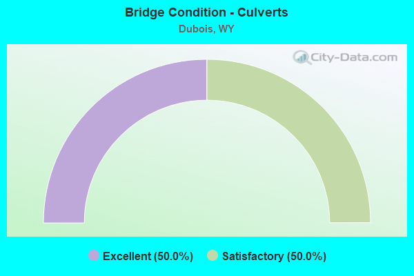
- Bridge Condition - Culverts
- 50.0%Excellent
- 50.0%Satisfactory
Find on map >> Show street view
Structure Number: C837, Location: 1.5 KM SE OF CROWHEART (Lat: 43.301194, Lng: -109.188778), Route carried "on" structure: Federal lands road 31, Year Built: 1970, Status: Posted for load, Structure Length: 2.20m (7.22ft), Average Daily Traffic: 50 (year 2020), Truck Traffic: 15%, Average Future Daily Traffic: 60 (year 2040), Design Load: HS 15, Features Intersected: MEADOW CREEK
Minimum Vertical Clearance: 30+ m (98+ ft), Kilometerpoint: 4.600, Lanes on structure: 2, Owner: Bureau of Indian Affairs, Approaching Roadway Width: 6.1m (20.0ft), Material/Design: Wood or Timber, Design/Construction: Stringer/Multi-beam, Number Of Spans In Main Unit: 3, Length of Maximum Span: 7.3m (24.0ft), Curb or Sidewalk Widths: Left: 0.1m (0.3ft), Right: 0.1m (0.3ft), Curb-To-Curb Width: 7.1m (23.3ft), Out-to-Out Width: 7.3m (24.0ft)
Condition: Deck: Satisfactory, Superstructure: Fair, Substructure: Good, Channel: Fair, Operating Rating: 30.9 metric tons, Method Used To Determine Operating Rating: Load Factor (LF), Inventory Rating: 21.7 metric tons, Method Used To Determine Inventory Rating: Load Factor (LF), Structural Evaluation: Somewhat better than minimum adequacy, Deck Geometry: Somewhat better than minimum adequacy, Waterway Adequacy: Equal to present minimum criteria, Approach Roadway Alignment: Equal to present desirable criteria, Bridge Posting: Required (Relationship of Operating Rating to Maximum Legal Load: > 39.9% below), Designated Inspection Frequency: Every 24 months, Inspection Date: October 2020, Deck Structure Type: Wood or Timber, Wearing Surface/Protective System: Wearing Surface: Bituminous
Find on map >> Show street view
Structure Number: C839, Location: 1KM N US 26/WILDERNESS RD (Lat: 43.434333, Lng: -109.360944), Route carried "on" structure: Federal lands road 280, Year Built: 1920, Status: Posted for load, Structure Length: 4.69m (15.39ft), Average Daily Traffic: 20 (year 2019), Truck Traffic: 10%, Average Future Daily Traffic: 30 (year 2039), Features Intersected: BIG WIND RIVER
Minimum Vertical Clearance: 30+ m (98+ ft), Kilometerpoint: 13.900, Lanes on structure: 1, Owner: Bureau of Indian Affairs, Approaching Roadway Width: 3.8m (12.5ft), Material/Design: Steel, Design/Construction: Truss - Thru, Number Of Spans In Main Unit: 1, Number Of Approach Spans: 1, Length of Maximum Span: 30.0m (98.4ft), Curb or Sidewalk Widths: Left: 0.2m (0.7ft), Right: 0.2m (0.7ft), Curb-To-Curb Width: 4.5m (14.8ft), Out-to-Out Width: 4.8m (15.7ft)
Condition: Deck: Fair, Superstructure: Fair, Substructure: Satisfactory, Channel: Good, Operating Rating: 9.1 metric tons, Method Used To Determine Operating Rating: Load Factor (LF), Inventory Rating: 3.9 metric tons, Method Used To Determine Inventory Rating: Load Factor (LF), Structural Evaluation: High priority of replacement, Deck Geometry: Equal to present minimum criteria, Waterway Adequacy: Equal to present minimum criteria, Approach Roadway Alignment: High priority of corrective action, Bridge Posting: Required (Relationship of Operating Rating to Maximum Legal Load: > 39.9% below), Length Of Structure Improvement: 6.50m (21.33ft), Designated Inspection Frequency: Every 12 months, Critical Feature Inspection Frequency: Every 12 months, Inspection Date: July 2019, Critical Feature Inspection Date: July 2019, Bridge Improvement Cost: $1,260,000, Roadway Improvement Cost: $100,000, Total Project Cost: $1,640,000 ( Estimate for 2019), Deck Structure Type: Wood or Timber, Wearing Surface/Protective System: Wearing Surface: Wood or Timber
Find on map >> Show street view
Structure Number: C842, Location: 4.4 KM NE OF CROWHEART (Lat: 43.330333, Lng: -109.149250), Route carried "on" structure: Federal lands road 32, Year Built: 2013, Status: Open, Structure Length: 0.75m (2.46ft), Average Daily Traffic: 15 (year 2020), Truck Traffic: 10%, Average Future Daily Traffic: 18 (year 2040), Design Load: HS 20, Features Intersected: CROW CREEK
Minimum Vertical Clearance: 30+ m (98+ ft), Kilometerpoint: 2.000, Lanes on structure: 2, Owner: Bureau of Indian Affairs, Approaching Roadway Width: 7.6m (24.9ft), Material/Design: Aluminum, Iron, Design/Construction: Culvert, Number Of Spans In Main Unit: 1, Length of Maximum Span: 7.5m (24.6ft), Curb-To-Curb Width: 7.5m (24.6ft), Out-to-Out Width: 7.5m (24.6ft)
Condition: Channel: Good, Culverts: Excellent, Operating Rating: 44.5 metric tons, Method Used To Determine Operating Rating: No rating analysis performed, Inventory Rating: 32.7 metric tons, Method Used To Determine Inventory Rating: No rating analysis performed, Structural Evaluation: Superior to present desirable criteria, Deck Geometry: Equal to present minimum criteria, Waterway Adequacy: Equal to present desirable criteria, Approach Roadway Alignment: Equal to present minimum criteria, Designated Inspection Frequency: Every 24 months, Inspection Date: October 2020
Find on map >> Show street view
Structure Number: DHH, Location: Moran Jct - Dubois (Lat: 43.533719, Lng: -109.633111), Route carried "on" structure: US 26, Year Built: 1981, Status: Open, Structure Length: 3.63m (11.91ft), Average Daily Traffic: 2,068 (year 2021), Truck Traffic: 6%, Average Future Daily Traffic: 2,895 (year 2041), Design Load: HS 20, Features Intersected: Horse Creek
Minimum Vertical Clearance: 30+ m (98+ ft), Kilometerpoint: 88.990, Lanes on structure: 4, Base Highway Network: Yes (Inventory Route: ML3, Subroute: 3), Owner: State Highway Agency, Approaching Roadway Width: 19.5m (64.0ft), Material/Design: Steel continuous, Design/Construction: Stringer/Multi-beam, Number Of Spans In Main Unit: 3, Length of Maximum Span: 13.7m (44.9ft), Curb or Sidewalk Widths: Left: 1.5m (4.9ft), Right: 1.5m (4.9ft), Curb-To-Curb Width: 16.5m (54.1ft), Out-to-Out Width: 20.7m (67.9ft)
Condition: Deck: Fair, Superstructure: Good, Substructure: Good, Channel: Good, Operating Rating: 59.9 metric tons, Method Used To Determine Operating Rating: Load Factor (LF), Inventory Rating: 35.4 metric tons, Method Used To Determine Inventory Rating: Load Factor (LF), Structural Evaluation: Better than present minimum criteria, Deck Geometry: Meets minimum limits, Waterway Adequacy: Equal to present desirable criteria, Approach Roadway Alignment: Equal to present desirable criteria, Designated Inspection Frequency: Every 24 months, Inspection Date: September 2021, Deck Structure Type: Concrete Cast-file-Place
Find on map >> Show street view
Structure Number: ELO, Location: Dubois (Lat: 43.531125, Lng: -109.634383), Route carried "on" structure: City street 105-2, Year Built: 1935, Status: Posted for load, Structure Length: 3.14m (10.30ft), Average Daily Traffic: 263 (year 2021), Truck Traffic: 8%, Average Future Daily Traffic: 368 (year 2041), Features Intersected: Big Wind River, Facility Carried by Structure: 3rd Street
Minimum Vertical Clearance: 30+ m (98+ ft), Kilometerpoint: 160.642, Lanes on structure: 2, Owner: City or Municipal Highway Agency, Approaching Roadway Width: 5.5m (18.0ft), Material/Design: Steel, Design/Construction: Truss - Thru, Number Of Spans In Main Unit: 1, Length of Maximum Span: 30.5m (100.1ft), Curb-To-Curb Width: 6.4m (21.0ft), Out-to-Out Width: 6.4m (21.0ft)
Condition: Deck: Very good, Superstructure: Fair, Substructure: Satisfactory, Channel: Very good, Operating Rating: 22.9 metric tons, Method Used To Determine Operating Rating: Allowable Stress (AS), Inventory Rating: 15.3 metric tons, Method Used To Determine Inventory Rating: Allowable Stress (AS), Structural Evaluation: Meets minimum limits, Deck Geometry: Meets minimum limits, Waterway Adequacy: Equal to present desirable criteria, Approach Roadway Alignment: Equal to present minimum criteria, Bridge Posting: Required (Relationship of Operating Rating to Maximum Legal Load: > 39.9% below), Length Of Structure Improvement: 3.96m (12.99ft), Designated Inspection Frequency: Every 12 months, Critical Feature Inspection Frequency: Every 24 months, Inspection Date: April 2021, Critical Feature Inspection Date: April 2020, Bridge Improvement Cost: $372,000, Roadway Improvement Cost: $37,000, Total Project Cost: $559,000 ( Estimate for 2014), Deck Structure Type: Corrugated Steel, Wearing Surface/Protective System: Wearing Surface: Bituminous
Find on map >> Show street view
Structure Number: ELP, Location: Dubois Streets (Lat: 43.532692, Lng: -109.633111), Route carried "on" structure: City street 105-1, Year Built: 1979, Status: Open, Structure Length: 2.10m (6.89ft), Average Daily Traffic: 169 (year 2021), Truck Traffic: 8%, Average Future Daily Traffic: 237 (year 2041), Design Load: HS 20, Features Intersected: Horse Creek, Facility Carried by Structure: E. Welty Street
Minimum Vertical Clearance: 30+ m (98+ ft), Kilometerpoint: 160.856, Lanes on structure: 2, Owner: City or Municipal Highway Agency, Approaching Roadway Width: 9.8m (32.2ft), Skew: 4 degrees, Material/Design: Concrete continuous, Design/Construction: Culvert, Number Of Spans In Main Unit: 5, Length of Maximum Span: 3.0m (9.8ft), Curb or Sidewalk Widths: Left: 1.5m (4.9ft), Right: 0.0m, Curb-To-Curb Width: 9.8m (32.2ft), Out-to-Out Width: 12.3m (40.4ft)
Condition: Channel: Good, Culverts: Satisfactory, Operating Rating: 54.4 metric tons, Method Used To Determine Operating Rating: Allowable Stress (AS), Inventory Rating: 32.7 metric tons, Method Used To Determine Inventory Rating: Allowable Stress (AS), Structural Evaluation: Equal to present minimum criteria, Deck Geometry: Better than present minimum criteria, Waterway Adequacy: Equal to present minimum criteria, Approach Roadway Alignment: Equal to present desirable criteria, Length Of Structure Improvement: 1.83m (6.00ft), Designated Inspection Frequency: Every 24 months, Inspection Date: April 2020, Bridge Improvement Cost: $10,000, Roadway Improvement Cost: $1,000, Total Project Cost: $12,000 ( Estimate for 2014), Deck Structure Type: Concrete Cast-file-Place
Find on map >> Show street view
Structure Number: ELQ, Location: 2 Mi. S.E. Of Dubois (Lat: 43.519400, Lng: -109.605208), Route carried "on" structure: County highway 800, Year Built: 1921, Status: Posted for load, Structure Length: 5.09m (16.70ft), Average Daily Traffic: 78 (year 2021), Truck Traffic: 8%, Average Future Daily Traffic: 109 (year 2041), Features Intersected: Big Wind River, Facility Carried by Structure: Fr Cnty Rd 238
Minimum Vertical Clearance: 4.28m (14.04ft), Kilometerpoint: 0.063, Lanes on structure: 1, Owner: County Highway Agency, Approaching Roadway Width: 4.6m (15.1ft), Material/Design: Steel, Design/Construction: Truss - Thru, Number Of Spans In Main Unit: 1, Number Of Approach Spans: 2, Length of Maximum Span: 38.4m (126.0ft), Curb-To-Curb Width: 4.8m (15.7ft), Out-to-Out Width: 4.9m (16.1ft)
Condition: Deck: Satisfactory, Superstructure: Fair, Substructure: Satisfactory, Channel: Good, Operating Rating: 27.6 metric tons, Method Used To Determine Operating Rating: Allowable Stress (AS), Inventory Rating: 14.4 metric tons, Method Used To Determine Inventory Rating: Allowable Stress (AS), Structural Evaluation: Meets minimum limits, Deck Geometry: High priority of replacement, Waterway Adequacy: Equal to present desirable criteria, Approach Roadway Alignment: Equal to present minimum criteria, Bridge Posting: Required (Relationship of Operating Rating to Maximum Legal Load: 30.0 - 39.9% below), Length Of Structure Improvement: 6.07m (19.91ft), Designated Inspection Frequency: Every 12 months, Critical Feature Inspection Frequency: Every 24 months, Inspection Date: April 2021, Critical Feature Inspection Date: April 2020, Bridge Improvement Cost: $570,000, Roadway Improvement Cost: $57,000, Total Project Cost: $856,000 ( Estimate for 2014), Deck Structure Type: Wood or Timber, Wearing Surface/Protective System: Wearing Surface: Bituminous
Find on map >> Show street view
Structure Number: EUT, Location: Dubois-Diversion Dam Jct (Lat: 43.501847, Lng: -109.554811), Route carried "on" structure: US 287, Year Built: 1983, Status: Open, Structure Length: 2.79m (9.15ft), Average Daily Traffic: 2,068 (year 2021), Truck Traffic: 6%, Average Future Daily Traffic: 2,895 (year 2041), Design Load: HS 20, Features Intersected: South Fork Torrey Creek, Facility Carried by Structure: US 26
Minimum Vertical Clearance: 30+ m (98+ ft), Kilometerpoint: 96.936, Lanes on structure: 2, Base Highway Network: Yes (Inventory Route: ML3, Subroute: 3), Owner: State Highway Agency, Approaching Roadway Width: 11.6m (38.1ft), Material/Design: Steel continuous, Design/Construction: Stringer/Multi-beam, Number Of Spans In Main Unit: 2, Length of Maximum Span: 13.4m (44.0ft), Curb-To-Curb Width: 12.2m (40.0ft), Out-to-Out Width: 13.0m (42.7ft)
Condition: Deck: Good, Superstructure: Good, Substructure: Good, Channel: Satisfactory, Operating Rating: 60.8 metric tons, Method Used To Determine Operating Rating: Load Factor (LF), Inventory Rating: 36.3 metric tons, Method Used To Determine Inventory Rating: Load Factor (LF), Structural Evaluation: Better than present minimum criteria, Deck Geometry: Equal to present minimum criteria, Waterway Adequacy: Equal to present desirable criteria, Approach Roadway Alignment: Equal to present minimum criteria, Designated Inspection Frequency: Every 24 months, Inspection Date: September 2021, Deck Structure Type: Concrete Cast-file-Place, Wearing Surface/Protective System: Wearing Surface: Epoxy Overlay
Find on map >> Show street view
Structure Number: EUU, Location: Dubois-Diversion Dam Jct (Lat: 43.502383, Lng: -109.555967), Route carried "on" structure: US 287, Year Built: 1983, Status: Open, Structure Length: 1.52m (4.99ft), Average Daily Traffic: 2,068 (year 2021), Truck Traffic: 6%, Average Future Daily Traffic: 2,895 (year 2041), Design Load: HS 20, Features Intersected: North Fork Torrey Creek, Facility Carried by Structure: US 26
Minimum Vertical Clearance: 30+ m (98+ ft), Kilometerpoint: 96.825, Lanes on structure: 2, Base Highway Network: Yes (Inventory Route: ML3, Subroute: 3), Owner: State Highway Agency, Approaching Roadway Width: 12.2m (40.0ft), Material/Design: Steel, Design/Construction: Stringer/Multi-beam, Number Of Spans In Main Unit: 1, Length of Maximum Span: 14.3m (46.9ft), Curb-To-Curb Width: 12.2m (40.0ft), Out-to-Out Width: 13.0m (42.7ft)
Condition: Deck: Good, Superstructure: Good, Substructure: Good, Channel: Very good, Operating Rating: 59.9 metric tons, Method Used To Determine Operating Rating: Load Factor (LF), Inventory Rating: 35.4 metric tons, Method Used To Determine Inventory Rating: Load Factor (LF), Structural Evaluation: Better than present minimum criteria, Deck Geometry: Equal to present minimum criteria, Waterway Adequacy: Equal to present desirable criteria, Approach Roadway Alignment: Equal to present minimum criteria, Designated Inspection Frequency: Every 24 months, Inspection Date: September 2021, Deck Structure Type: Concrete Cast-file-Place, Wearing Surface/Protective System: Wearing Surface: Epoxy Overlay
Find on map >> Show street view
Structure Number: EUV, Location: Dubois-Diversion Dam Jct (Lat: 43.514344, Lng: -109.570600), Route carried "on" structure: US 287, Year Built: 1983, Status: Open, Structure Length: 3.60m (11.81ft), Average Daily Traffic: 2,068 (year 2021), Truck Traffic: 6%, Average Future Daily Traffic: 2,895 (year 2041), Design Load: HS 20, Features Intersected: Jakeys Fork, Facility Carried by Structure: US 26
Minimum Vertical Clearance: 30+ m (98+ ft), Kilometerpoint: 94.985, Lanes on structure: 2, Base Highway Network: Yes (Inventory Route: ML3, Subroute: 3), Owner: State Highway Agency, Approaching Roadway Width: 12.2m (40.0ft), Skew: 2 degrees, Material/Design: Steel continuous, Design/Construction: Stringer/Multi-beam, Number Of Spans In Main Unit: 2, Length of Maximum Span: 17.4m (57.1ft), Curb-To-Curb Width: 12.2m (40.0ft), Out-to-Out Width: 13.0m (42.7ft)
Condition: Deck: Good, Superstructure: Good, Substructure: Good, Channel: Very good, Operating Rating: 59.9 metric tons, Method Used To Determine Operating Rating: Load Factor (LF), Inventory Rating: 35.4 metric tons, Method Used To Determine Inventory Rating: Load Factor (LF), Structural Evaluation: Better than present minimum criteria, Deck Geometry: Equal to present minimum criteria, Waterway Adequacy: Equal to present desirable criteria, Approach Roadway Alignment: Equal to present desirable criteria, Designated Inspection Frequency: Every 24 months, Inspection Date: September 2021, Deck Structure Type: Concrete Cast-file-Place
Find on map >> Show street view
Structure Number: EUW, Location: Dubois-Diversion Dam Jct (Lat: 43.522808, Lng: -109.610636), Route carried "on" structure: US 287, Year Built: 1983, Status: Open, Structure Length: 4.79m (15.72ft), Average Daily Traffic: 2,068 (year 2021), Truck Traffic: 6%, Average Future Daily Traffic: 2,895 (year 2041), Design Load: HS 20, Features Intersected: Wind River, Facility Carried by Structure: US 26
Minimum Vertical Clearance: 30+ m (98+ ft), Kilometerpoint: 91.387, Lanes on structure: 2, Base Highway Network: Yes (Inventory Route: ML3, Subroute: 3), Owner: State Highway Agency, Approaching Roadway Width: 12.2m (40.0ft), Material/Design: Steel continuous, Design/Construction: Stringer/Multi-beam, Number Of Spans In Main Unit: 3, Length of Maximum Span: 18.3m (60.0ft), Curb-To-Curb Width: 12.2m (40.0ft), Out-to-Out Width: 13.0m (42.7ft)
Condition: Deck: Satisfactory, Superstructure: Good, Substructure: Good, Channel: Satisfactory, Operating Rating: 58.1 metric tons, Method Used To Determine Operating Rating: Load Factor (LF), Inventory Rating: 34.5 metric tons, Method Used To Determine Inventory Rating: Load Factor (LF), Structural Evaluation: Better than present minimum criteria, Deck Geometry: Equal to present minimum criteria, Waterway Adequacy: Equal to present desirable criteria, Approach Roadway Alignment: Equal to present desirable criteria, Designated Inspection Frequency: Every 24 months, Inspection Date: September 2021, Deck Structure Type: Concrete Cast-file-Place
Find on map >> Show street view
Structure Number: FHT, Location: T41N R107W S01 (Lat: 43.537883, Lng: -109.650439), Route carried "on" structure: City street 105-3, Year Built: 1988, Status: Open, Structure Length: 3.11m (10.20ft), Average Daily Traffic: 1,516 (year 2021), Truck Traffic: 2%, Average Future Daily Traffic: 2,122 (year 2041), Design Load: HS 20, Features Intersected: Big Wind River, Facility Carried by Structure: Mickel Drive
Minimum Vertical Clearance: 30+ m (98+ ft), Kilometerpoint: 159.459, Lanes on structure: 1, Owner: City or Municipal Highway Agency, Approaching Roadway Width: 6.1m (20.0ft), Material/Design: Steel continuous, Design/Construction: Stringer/Multi-beam, Number Of Spans In Main Unit: 2, Length of Maximum Span: 14.9m (48.9ft), Curb-To-Curb Width: 4.3m (14.1ft), Out-to-Out Width: 5.1m (16.7ft)
Condition: Deck: Satisfactory, Superstructure: Good, Substructure: Good, Channel: Good, Operating Rating: 67.1 metric tons, Method Used To Determine Operating Rating: Load Factor (LF), Inventory Rating: 39.0 metric tons, Method Used To Determine Inventory Rating: Load Factor (LF), Structural Evaluation: Better than present minimum criteria, Deck Geometry: High priority of replacement, Waterway Adequacy: Equal to present desirable criteria, Approach Roadway Alignment: High priority of corrective action, Length Of Structure Improvement: 0.18m (0.59ft), Designated Inspection Frequency: Every 24 months, Inspection Date: April 2020, Bridge Improvement Cost: $6,000, Roadway Improvement Cost: $1,000, Total Project Cost: $8,000 ( Estimate for 2014), Deck Structure Type: Concrete Cast-file-Place, Wearing Surface/Protective System: Deck Protection: Epoxy Coated Reinforcing
Find on map >> Show street view
Structure Number: FJZ, Location: Dubois Streets (Lat: 43.536158, Lng: -109.633194), Route carried "on" structure: City street 105-5, Year Built: 1937, Status: Posted for load, Structure Length: 3.17m (10.40ft), Average Daily Traffic: 433 (year 2021), Truck Traffic: 8%, Average Future Daily Traffic: 606 (year 2041), Design Load: H 15, Features Intersected: Horse Creek, Facility Carried by Structure: Clendenning Street
Minimum Vertical Clearance: 30+ m (98+ ft), Kilometerpoint: 160.857, Lanes on structure: 2, Owner: City or Municipal Highway Agency, Approaching Roadway Width: 10.4m (34.1ft), Material/Design: Steel, Design/Construction: Truss - Thru, Number Of Spans In Main Unit: 1, Length of Maximum Span: 30.5m (100.1ft), Curb or Sidewalk Widths: Left: 0.1m (0.3ft), Right: 1.2m (3.9ft), Curb-To-Curb Width: 7.3m (24.0ft), Out-to-Out Width: 9.6m (31.5ft)
Condition: Deck: Good, Superstructure: Satisfactory, Substructure: Very good, Channel: Good, Operating Rating: 30.7 metric tons, Method Used To Determine Operating Rating: Allowable Stress (AS), Inventory Rating: 8.8 metric tons, Method Used To Determine Inventory Rating: Allowable Stress (AS), Structural Evaluation: High priority of corrective action, Deck Geometry: Meets minimum limits, Waterway Adequacy: Equal to present desirable criteria, Approach Roadway Alignment: Equal to present minimum criteria, Bridge Posting: Required (Relationship of Operating Rating to Maximum Legal Load: 10.0 - 19.9% below), Length Of Structure Improvement: 3.05m (10.01ft), Designated Inspection Frequency: Every 12 months, Critical Feature Inspection Frequency: Every 24 months, Inspection Date: April 2021, Critical Feature Inspection Date: April 2020, Bridge Improvement Cost: $10,000, Roadway Improvement Cost: $1,000, Total Project Cost: $12,000 ( Estimate for 2014), Deck Structure Type: Concrete Cast-file-Place, Wearing Surface/Protective System: Deck Protection: Epoxy Coated Reinforcing
Find on map >> Show street view
Structure Number: KSX, Location: 2 M. W. Of Dwntn Dubois (Lat: 43.546517, Lng: -109.667244), Route carried "on" structure: County highway 283, Year Built: 1998, Status: Open, Structure Length: 4.02m (13.19ft), Average Daily Traffic: 401 (year 2021), Truck Traffic: 5%, Average Future Daily Traffic: 561 (year 2041), Design Load: HS 25 or greater, Features Intersected: Big Wind River
Minimum Vertical Clearance: 30+ m (98+ ft), Kilometerpoint: 0.547, Lanes on structure: 2, Owner: County Highway Agency, Approaching Roadway Width: 7.6m (24.9ft), Skew: 1 degrees, Material/Design: Prestressed concrete, Design/Construction: Stringer/Multi-beam, Number Of Spans In Main Unit: 2, Length of Maximum Span: 19.2m (63.0ft), Curb-To-Curb Width: 7.8m (25.6ft), Out-to-Out Width: 8.8m (28.9ft)
Condition: Deck: Good, Superstructure: Very good, Substructure: Good, Channel: Good, Operating Rating: 76.2 metric tons, Method Used To Determine Operating Rating: Load Factor (LF), Inventory Rating: 47.2 metric tons, Method Used To Determine Inventory Rating: Load Factor (LF), Structural Evaluation: Better than present minimum criteria, Deck Geometry: Meets minimum limits, Waterway Adequacy: Equal to present desirable criteria, Approach Roadway Alignment: Equal to present minimum criteria, Length Of Structure Improvement: 0.03m (0.10ft), Designated Inspection Frequency: Every 24 months, Inspection Date: March 2021, Bridge Improvement Cost: $1,000, Roadway Improvement Cost: $1,000, Total Project Cost: $3,000, Deck Structure Type: Concrete Cast-file-Place
Find on map >> Show street view
Structure Number: LDW, Location: 3 Mi Se Of Dubois (Lat: 43.516806, Lng: -109.594553), Route carried "on" structure: County highway 239, Year Built: 2002, Status: Open, Structure Length: 3.44m (11.29ft), Average Daily Traffic: 194 (year 2021), Truck Traffic: 8%, Average Future Daily Traffic: 272 (year 2041), Features Intersected: Big Wind River
Minimum Vertical Clearance: 30+ m (98+ ft), Kilometerpoint: 0.169, Lanes on structure: 2, Owner: County Highway Agency, Approaching Roadway Width: 6.7m (22.0ft), Material/Design: Steel, Design/Construction: Stringer/Multi-beam, Number Of Spans In Main Unit: 2, Length of Maximum Span: 16.6m (54.5ft), Curb-To-Curb Width: 6.1m (20.0ft), Out-to-Out Width: 6.1m (20.0ft)
Condition: Deck: Good, Superstructure: Satisfactory, Substructure: Good, Channel: Good, Operating Rating: 71.7 metric tons, Method Used To Determine Operating Rating: Load Factor (LF), Inventory Rating: 42.6 metric tons, Method Used To Determine Inventory Rating: Load Factor (LF), Structural Evaluation: Equal to present minimum criteria, Deck Geometry: Meets minimum limits, Waterway Adequacy: Equal to present desirable criteria, Approach Roadway Alignment: Better than present minimum criteria, Length Of Structure Improvement: 8.05m (26.41ft), Designated Inspection Frequency: Every 24 months, Inspection Date: April 2020, Bridge Improvement Cost: $23,000, Roadway Improvement Cost: $30,000, Total Project Cost: $55,000 ( Estimate for 2014), Deck Structure Type: Corrugated Steel, Wearing Surface/Protective System: Wearing Surface: Bituminous
Find on map >> Show street view
Structure Number: MZL, Location: .8 Miles S. of US 26 (Lat: 43.539642, Lng: -109.654939), Route carried "on" structure: City street , Year Built: 2016, Status: Posted for load, Structure Length: 1.85m (6.07ft), Average Daily Traffic: 401 (year 2021), Truck Traffic: 5%, Average Future Daily Traffic: 561 (year 2041), Design Load: HL 93, Features Intersected: Wind River, Facility Carried by Structure: Rhoads Street
Minimum Vertical Clearance: 30+ m (98+ ft), Kilometerpoint: 159.074, Lanes on structure: 2, Owner: Town or Township Highway Agency, Approaching Roadway Width: 6.1m (20.0ft), Material/Design: Steel, Design/Construction: Stringer/Multi-beam, Number Of Spans In Main Unit: 1, Length of Maximum Span: 0.0m, Curb-To-Curb Width: 4.9m (16.1ft), Out-to-Out Width: 4.9m (16.1ft)
Condition: Deck: Very good, Superstructure: Very good, Substructure: Very good, Channel: Very good, Operating Rating: 46.3 metric tons, Method Used To Determine Operating Rating: Load and Resistance Factor Rating (LRFR) rating reported by rating factor(RF) method using HL-93 loadings, Inventory Rating: 35.6 metric tons, Method Used To Determine Inventory Rating: Load and Resistance Factor Rating (LRFR) rating reported by rating factor(RF) method using HL-93 loadings, Structural Evaluation: Equal to present desirable criteria, Deck Geometry: High priority of replacement, Waterway Adequacy: Equal to present desirable criteria, Approach Roadway Alignment: Equal to present minimum criteria, Designated Inspection Frequency: Every 24 months, Inspection Date: April 2020, Deck Structure Type: Corrugated Steel, Wearing Surface/Protective System: Wearing Surface: Wood or Timber
Find on map >> Show street view
Structure Number: NDY, Location: Dubois (Lat: 43.525219, Lng: -109.616933), Route carried "on" structure: City street , Year Built: 2019, Status: Open, Structure Length: 3.27m (10.73ft), Average Daily Traffic: 2,863 (year 2021), Truck Traffic: 2%, Average Future Daily Traffic: 4,008 (year 2041), Features Intersected: Wind River, Facility Carried by Structure: Absoroka Drive
Minimum Vertical Clearance: 30+ m (98+ ft), Kilometerpoint: 161.165, Lanes on structure: 2, Owner: City or Municipal Highway Agency, Approaching Roadway Width: 7.3m (24.0ft), Material/Design: Steel, Design/Construction: Stringer/Multi-beam, Number Of Spans In Main Unit: 4, Length of Maximum Span: 8.8m (28.9ft), Curb or Sidewalk Widths: Left: 1.5m (4.9ft), Right: 0.2m (0.7ft), Curb-To-Curb Width: 5.3m (17.4ft), Out-to-Out Width: 7.3m (24.0ft)
Condition: Deck: Good, Superstructure: Satisfactory, Substructure: Fair, Channel: Satisfactory, Operating Rating: 99.2 metric tons, Method Used To Determine Operating Rating: Load Factor (LF), Inventory Rating: 59.4 metric tons, Method Used To Determine Inventory Rating: Load Factor (LF), Structural Evaluation: Somewhat better than minimum adequacy, Deck Geometry: High priority of replacement, Waterway Adequacy: Equal to present desirable criteria, Approach Roadway Alignment: Equal to present desirable criteria, Designated Inspection Frequency: Every 24 months, Inspection Date: March 2021, Deck Structure Type: Wood or Timber, Wearing Surface/Protective System: Wearing Surface: Wood or Timber