Bridge Statistics for Duenweg, Missouri (MO)
Condition, Traffic, Stress, Structural Evaluation, Project Costs
- National Bridge Inventory (NBI) Statistics
- 17Number of bridges
- 167ft / 51.5mTotal length
- $1,899,000Total costs
- 121,375Total average daily traffic
- 30,517Total average daily truck traffic
- National Bridge Inventory (NBI) Registered Bridges for Duenweg
- No street view available for this location
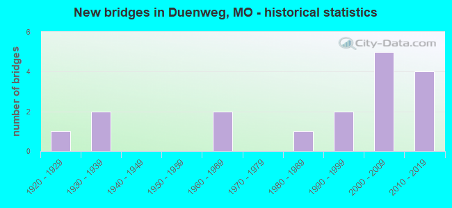
- New bridges - historical statistics
- 11920-1929
- 21930-1939
- 21960-1969
- 11980-1989
- 21990-1999
- 52000-2009
- 42010-2019

- Reconstructed bridges - Historical Statistics
- 11940-1949
- 01950-1959
- 01960-1969
- 01970-1979
- 01980-1989
- 21990-1999


- Bridge Condition - Deck
- 9.1%Excellent
- 18.2%Very good
- 54.5%Good
- 9.1%Satisfactory
- 9.1%Fair

- Bridge Condition - Superstructure
- 18.2%Excellent
- 36.4%Very good
- 27.3%Good
- 9.1%Satisfactory
- 9.1%Fair

- Bridge Condition - Substructure
- 18.2%Excellent
- 9.1%Very good
- 27.3%Good
- 27.3%Satisfactory
- 9.1%Fair
- 9.1%Poor

- Bridge Condition - Channel
- 45.5%Very good
- 18.2%Good
- 18.2%Satisfactory
- 18.2%Fair

- Bridge Condition - Culverts
- 50.0%Very good
- 50.0%Fair
Find on map >> Show street view
Structure Number: 25026, Location: S 10 T 27 N R 32 W (Lat: 37.071942, Lng: -94.404800), Route carried "on" structure: County highway 600, Year Built: 1989, Status: Open, Structure Length: 1.31m (4.30ft), Average Daily Traffic: 1,000 (year 2021), Truck Traffic: 30%, Average Future Daily Traffic: 1,500 (year 2041), Features Intersected: TURKEY CR, Facility Carried by Structure: PRIGMOR AVE
Minimum Vertical Clearance: 30+ m (98+ ft), Kilometerpoint: 1.287, Lanes on structure: 2, Owner: County Highway Agency, Approaching Roadway Width: 6.1m (20.0ft), Material/Design: Concrete, Design/Construction: Culvert, Number Of Spans In Main Unit: 3, Length of Maximum Span: 4.0m (13.1ft), Curb-To-Curb Width: 11.3m (37.1ft), Out-to-Out Width: 11.9m (39.0ft)
Condition: Channel: Satisfactory, Culverts: Very good, Operating Rating: 49.5 metric tons, Method Used To Determine Operating Rating: Allowable Stress (AS), Inventory Rating: 32.4 metric tons, Method Used To Determine Inventory Rating: Allowable Stress (AS), Structural Evaluation: Equal to present desirable criteria, Deck Geometry: Better than present minimum criteria, Waterway Adequacy: Equal to present desirable criteria, Approach Roadway Alignment: Equal to present desirable criteria, Designated Inspection Frequency: Every 24 months, Inspection Date: January 2021
Find on map >> Show street view
Structure Number: 25032, Location: S 10 T 27 N R 32 W (Lat: 37.073844, Lng: -94.413875), Route carried "on" structure: County highway 603, Year Built: 1930, Year Reconstructed: 1953, Status: Open, Structure Length: 0.82m (2.69ft), Average Daily Traffic: 200 (year 2021), Truck Traffic: 10%, Average Future Daily Traffic: 300 (year 2041), Design Load: H 10, Features Intersected: TURKEY CR, Facility Carried by Structure: S IRWIN ST
Minimum Vertical Clearance: 30+ m (98+ ft), Kilometerpoint: 0.161, Lanes on structure: 2, Owner: County Highway Agency, Approaching Roadway Width: 6.1m (20.0ft), Material/Design: Concrete, Design/Construction: Slab, Number Of Spans In Main Unit: 2, Length of Maximum Span: 3.7m (12.1ft), Curb-To-Curb Width: 9.2m (30.2ft), Out-to-Out Width: 9.2m (30.2ft)
Condition: Deck: Fair, Superstructure: Fair, Substructure: Fair, Channel: Good, Operating Rating: 25.2 metric tons, Method Used To Determine Operating Rating: Allowable Stress (AS), Inventory Rating: 14.4 metric tons, Method Used To Determine Inventory Rating: Allowable Stress (AS), Structural Evaluation: Meets minimum limits, Deck Geometry: Equal to present minimum criteria, Waterway Adequacy: High priority of corrective action, Approach Roadway Alignment: Equal to present desirable criteria, Length Of Structure Improvement: 0.15m (0.49ft), Designated Inspection Frequency: Every 24 months, Inspection Date: January 2021, Bridge Improvement Cost: $74,000, Roadway Improvement Cost: $7,000, Total Project Cost: $111,000 ( Estimate for 2022), Deck Structure Type: Concrete Cast-file-Place, Wearing Surface/Protective System: Wearing Surface: Bituminous
Find on map >> Show street view
Structure Number: 25047, Location: S 10 T 27 N R 32 W (Lat: 37.074583, Lng: -94.423019), Route carried "on" structure: County highway 606, Year Built: 1992, Status: Open, Structure Length: 2.41m (7.91ft), Average Daily Traffic: 200 (year 2021), Truck Traffic: 10%, Average Future Daily Traffic: 300 (year 2041), Design Load: HS 20, Features Intersected: TURKEY CR, Facility Carried by Structure: PROSPERITY AVE
Minimum Vertical Clearance: 30+ m (98+ ft), Kilometerpoint: 0.161, Lanes on structure: 2, Owner: County Highway Agency, Approaching Roadway Width: 6.1m (20.0ft), Material/Design: Prestressed concrete, Design/Construction: Tee Beam, Number Of Spans In Main Unit: 3, Length of Maximum Span: 7.9m (25.9ft), Curb-To-Curb Width: 7.3m (24.0ft), Out-to-Out Width: 7.5m (24.6ft)
Condition: Deck: Good, Superstructure: Very good, Substructure: Satisfactory, Channel: Very good, Operating Rating: 81.0 metric tons, Method Used To Determine Operating Rating: Allowable Stress (AS), Inventory Rating: 48.6 metric tons, Method Used To Determine Inventory Rating: Allowable Stress (AS), Structural Evaluation: Equal to present minimum criteria, Deck Geometry: Somewhat better than minimum adequacy, Waterway Adequacy: Equal to present desirable criteria, Approach Roadway Alignment: Equal to present desirable criteria, Designated Inspection Frequency: Every 24 months, Inspection Date: January 2021, Deck Structure Type: Concrete Cast-file-Place, Wearing Surface/Protective System: Wearing Surface: Monolithic Concrete
Find on map >> Show street view
Structure Number: 25236, Location: S 9 T 27 N R 32 W (Lat: 37.081878, Lng: -94.436433), Route carried "on" structure: County highway 705, Year Built: 1930, Status: Open, Structure Length: 0.73m (2.40ft), Average Daily Traffic: 250 (year 2021), Truck Traffic: 10%, Average Future Daily Traffic: 375 (year 2041), Design Load: H 20, Features Intersected: TRIB TO TURKEY CR, Facility Carried by Structure: KENSER RD
Minimum Vertical Clearance: 30+ m (98+ ft), Kilometerpoint: 0.161, Lanes on structure: 2, Owner: County Highway Agency, Approaching Roadway Width: 6.7m (22.0ft), Material/Design: Concrete, Design/Construction: Slab, Number Of Spans In Main Unit: 2, Length of Maximum Span: 3.0m (9.8ft), Curb-To-Curb Width: 7.5m (24.6ft), Out-to-Out Width: 7.5m (24.6ft)
Condition: Deck: Good, Superstructure: Good, Substructure: Good, Channel: Fair, Operating Rating: 43.2 metric tons, Method Used To Determine Operating Rating: Allowable Stress (AS), Inventory Rating: 25.2 metric tons, Method Used To Determine Inventory Rating: Allowable Stress (AS), Structural Evaluation: Equal to present minimum criteria, Deck Geometry: Somewhat better than minimum adequacy, Waterway Adequacy: Equal to present desirable criteria, Approach Roadway Alignment: Equal to present desirable criteria, Designated Inspection Frequency: Every 24 months, Inspection Date: January 2021, Deck Structure Type: Concrete Cast-file-Place, Wearing Surface/Protective System: Wearing Surface: Bituminous
Find on map >> Show street view
Structure Number: 28446, Location: S 9 T 27 N R 32 W (Lat: 37.078761, Lng: -94.436581), Route carried "on" structure: County highway 705, Year Built: 1999, Status: Open, Structure Length: 6.10m (20.01ft), Average Daily Traffic: 250 (year 2021), Truck Traffic: 10%, Average Future Daily Traffic: 375 (year 2041), Design Load: HS 20, Features Intersected: TURKEY CR, Facility Carried by Structure: KENSER RD
Minimum Vertical Clearance: 30+ m (98+ ft), Kilometerpoint: 0.483, Lanes on structure: 2, Owner: County Highway Agency, Approaching Roadway Width: 9.1m (29.9ft), Material/Design: Concrete continuous, Design/Construction: Slab, Number Of Spans In Main Unit: 5, Length of Maximum Span: 13.4m (44.0ft), Curb-To-Curb Width: 9.1m (29.9ft), Out-to-Out Width: 9.3m (30.5ft)
Condition: Deck: Very good, Superstructure: Very good, Substructure: Very good, Channel: Very good, Operating Rating: 72.9 metric tons, Method Used To Determine Operating Rating: Load Factor (LF), Inventory Rating: 44.1 metric tons, Method Used To Determine Inventory Rating: Load Factor (LF), Structural Evaluation: Equal to present desirable criteria, Deck Geometry: Equal to present minimum criteria, Waterway Adequacy: Superior to present desirable criteria, Approach Roadway Alignment: Equal to present desirable criteria, Designated Inspection Frequency: Every 24 months, Inspection Date: January 2021, Deck Structure Type: Concrete Cast-file-Place, Wearing Surface/Protective System: Wearing Surface: Monolithic Concrete
Find on map >> Show street view
Structure Number: 28775, Location: S 11 T 27 N R 32 W (Lat: 37.068411, Lng: -94.389564), Route carried "on" structure: County highway 688, Year Built: 2000, Status: Open, Structure Length: 3.14m (10.30ft), Average Daily Traffic: 150 (year 2021), Truck Traffic: 10%, Average Future Daily Traffic: 225 (year 2041), Design Load: HS 20, Features Intersected: TURKEY CR, Facility Carried by Structure: APPLE RD
Minimum Vertical Clearance: 30+ m (98+ ft), Kilometerpoint: 1.609, Lanes on structure: 2, Owner: County Highway Agency, Approaching Roadway Width: 9.8m (32.2ft), Skew: 3 degrees, Material/Design: Concrete continuous, Design/Construction: Slab, Number Of Spans In Main Unit: 3, Length of Maximum Span: 12.2m (40.0ft), Curb-To-Curb Width: 7.3m (24.0ft), Out-to-Out Width: 7.5m (24.6ft)
Condition: Deck: Good, Superstructure: Good, Substructure: Good, Channel: Very good, Operating Rating: 87.3 metric tons, Method Used To Determine Operating Rating: Load Factor (LF), Inventory Rating: 52.2 metric tons, Method Used To Determine Inventory Rating: Load Factor (LF), Structural Evaluation: Better than present minimum criteria, Deck Geometry: Somewhat better than minimum adequacy, Waterway Adequacy: Superior to present desirable criteria, Approach Roadway Alignment: Equal to present desirable criteria, Designated Inspection Frequency: Every 24 months, Inspection Date: January 2021, Deck Structure Type: Concrete Cast-file-Place, Wearing Surface/Protective System: Wearing Surface: Monolithic Concrete
Find on map >> Show street view
Structure Number: 28999, Location: S 4 T 27 N R 32 W (Lat: 37.083289, Lng: -94.425150), Route carried "on" structure: State highway 66, Year Built: 2002, Status: Open, Structure Length: 8.72m (28.61ft), Average Daily Traffic: 8,983 (year 2021), Truck Traffic: 13%, Average Future Daily Traffic: 13,924 (year 2041), Design Load: HS 25 or greater, Features Intersected: MO 249
Minimum Vertical Clearance: 30+ m (98+ ft), Kilometerpoint: 17.339, Lanes on structure: 5, Lanes under structure: 4, Base Highway Network: Yes, Owner: State Highway Agency, Approaching Roadway Width: 24.6m (80.7ft), Material/Design: Steel continuous, Design/Construction: Stringer/Multi-beam, Number Of Spans In Main Unit: 2, Length of Maximum Span: 35.0m (114.8ft), Curb-To-Curb Width: 24.6m (80.7ft), Out-to-Out Width: 25.4m (83.3ft)
Condition: Deck: Good, Superstructure: Very good, Substructure: Good, Operating Rating: 73.8 metric tons, Method Used To Determine Operating Rating: Load Factor (LF), Inventory Rating: 45.0 metric tons, Method Used To Determine Inventory Rating: Load Factor (LF), Structural Evaluation: Better than present minimum criteria, Deck Geometry: Superior to present desirable criteria, Underclear: Somewhat better than minimum adequacy, Approach Roadway Alignment: Equal to present desirable criteria, Designated Inspection Frequency: Every 24 months, Inspection Date: August 2021, Deck Structure Type: Concrete Cast-file-Place, Wearing Surface/Protective System: Wearing Surface: Monolithic Concrete, Deck Protection: Epoxy Coated Reinforcing
Find on map >> Show street view
Structure Number: 31039, Location: S 9 T 27 N R 32 W (Lat: 37.075289, Lng: -94.426517), Route carried "on" structure: State highway 249, Year Built: 2005, Status: Open, Structure Length: 13.84m (45.41ft), Average Daily Traffic: 9,906 (year 2021), Truck Traffic: 20%, Average Future Daily Traffic: 17,831 (year 2041), Design Load: HS 20+Mod, Features Intersected: TURKEY CR
Minimum Vertical Clearance: 30+ m (98+ ft), Kilometerpoint: 7.878, Lanes on structure: 2, Base Highway Network: Yes, Owner: State Highway Agency, Approaching Roadway Width: 11.4m (37.4ft), Skew: 1 degrees, Material/Design: Prestressed concrete continuous, Design/Construction: Stringer/Multi-beam, Number Of Spans In Main Unit: 6, Length of Maximum Span: 29.0m (95.1ft), Curb-To-Curb Width: 11.4m (37.4ft), Out-to-Out Width: 12.2m (40.0ft)
Condition: Deck: Good, Superstructure: Very good, Substructure: Poor, Channel: Satisfactory, Operating Rating: 72.9 metric tons, Method Used To Determine Operating Rating: Load Factor (LF), Inventory Rating: 44.1 metric tons, Method Used To Determine Inventory Rating: Load Factor (LF), Structural Evaluation: Meets minimum limits, Deck Geometry: Somewhat better than minimum adequacy, Waterway Adequacy: Superior to present desirable criteria, Approach Roadway Alignment: Equal to present desirable criteria, Length Of Structure Improvement: 1.46m (4.79ft), Designated Inspection Frequency: Every 24 months, Inspection Date: August 2021, Bridge Improvement Cost: $1,192,000, Roadway Improvement Cost: $119,000, Total Project Cost: $1,788,000 ( Estimate for 2022), Deck Structure Type: Concrete Cast-file-Place, Wearing Surface/Protective System: Wearing Surface: Monolithic Concrete, Deck Protection: Epoxy Coated Reinforcing
Find on map >> Show street view
Structure Number: 34795, Location: S 11 T 27 N R 32 W (Lat: 37.069258, Lng: -94.403997), Route carried "on" structure: City street , Year Built: 2014, Status: Open, Structure Length: 4.45m (14.60ft), Average Daily Traffic: 2,516 (year 2021), Truck Traffic: 11%, Average Future Daily Traffic: 3,774 (year 2041), Features Intersected: IS 44, Facility Carried by Structure: PRIGMOR AVE S
Minimum Vertical Clearance: 30+ m (98+ ft), Kilometerpoint: 3.135, Lanes on structure: 2, Lanes under structure: 4, Owner: State Highway Agency, Approaching Roadway Width: 12.2m (40.0ft), Material/Design: Prestressed concrete continuous, Design/Construction: Stringer/Multi-beam, Number Of Spans In Main Unit: 2, Length of Maximum Span: 21.6m (70.9ft), Curb-To-Curb Width: 12.2m (40.0ft), Out-to-Out Width: 13.0m (42.7ft)
Condition: Deck: Very good, Superstructure: Excellent, Substructure: Excellent, Operating Rating: 77.4 metric tons, Method Used To Determine Operating Rating: Load Factor (LF), Inventory Rating: 36.9 metric tons, Method Used To Determine Inventory Rating: Load Factor (LF), Structural Evaluation: Superior to present desirable criteria, Deck Geometry: Equal to present minimum criteria, Underclear: Meets minimum limits, Approach Roadway Alignment: Equal to present desirable criteria, Designated Inspection Frequency: Every 24 months, Inspection Date: August 2021, Deck Structure Type: Concrete Cast-file-Place, Wearing Surface/Protective System: Wearing Surface: Monolithic Concrete, Deck Protection: Epoxy Coated Reinforcing
Find on map >> Show street view
Structure Number: 36207, Location: S 12 T 27 N R 32 W (Lat: 37.068467, Lng: -94.370769), Route carried "on" structure: County highway 688, Year Built: 2019, Status: Open, Structure Length: 2.23m (7.32ft), Average Daily Traffic: 150 (year 2021), Truck Traffic: 10%, Average Future Daily Traffic: 225 (year 2041), Design Load: HS 20, Features Intersected: GROVE CR, Facility Carried by Structure: APPLE RD
Minimum Vertical Clearance: 30+ m (98+ ft), Kilometerpoint: 3.058, Lanes on structure: 2, Owner: County Highway Agency, Approaching Roadway Width: 6.7m (22.0ft), Material/Design: Prestressed concrete, Design/Construction: Tee Beam, Number Of Spans In Main Unit: 1, Length of Maximum Span: 21.0m (68.9ft), Curb-To-Curb Width: 8.1m (26.6ft), Out-to-Out Width: 8.8m (28.9ft)
Condition: Deck: Excellent, Superstructure: Excellent, Substructure: Excellent, Channel: Very good, Operating Rating: 70.2 metric tons, Method Used To Determine Operating Rating: Load Factor (LF), Inventory Rating: 43.2 metric tons, Method Used To Determine Inventory Rating: Load Factor (LF), Structural Evaluation: Superior to present desirable criteria, Deck Geometry: Somewhat better than minimum adequacy, Waterway Adequacy: Superior to present desirable criteria, Approach Roadway Alignment: Equal to present desirable criteria, Designated Inspection Frequency: Every 24 months, Inspection Date: January 2021, Deck Structure Type: Concrete Precast Panels, Wearing Surface/Protective System: Wearing Surface: Monolithic Concrete
Find on map >> Show street view
Structure Number: 372, Location: S 11 T 27 N R 32 W (Lat: 37.072575, Lng: -94.394481), Route carried "on" structure: Interstate 44, Year Built: 1960, Year Reconstructed: 2003, Status: Open, Structure Length: 2.83m (9.28ft), Average Daily Traffic: 17,954 (year 2021), Truck Traffic: 32%, Average Future Daily Traffic: 32,317 (year 2041), Design Load: HS 20, Features Intersected: TURKEY CR
Minimum Vertical Clearance: 30+ m (98+ ft), Kilometerpoint: 449.552, Lanes on structure: 2, Base Highway Network: Yes, Owner: State Highway Agency, Approaching Roadway Width: 11.6m (38.1ft), Skew: 2 degrees, Material/Design: Concrete continuous, Design/Construction: Slab, Number Of Spans In Main Unit: 3, Length of Maximum Span: 9.6m (31.5ft), Curb-To-Curb Width: 12.2m (40.0ft), Out-to-Out Width: 13.0m (42.7ft)
Condition: Deck: Satisfactory, Superstructure: Satisfactory, Substructure: Satisfactory, Channel: Good, Operating Rating: 53.1 metric tons, Method Used To Determine Operating Rating: Load Factor (LF), Inventory Rating: 31.5 metric tons, Method Used To Determine Inventory Rating: Load Factor (LF), Structural Evaluation: Equal to present minimum criteria, Deck Geometry: Better than present minimum criteria, Waterway Adequacy: Equal to present desirable criteria, Approach Roadway Alignment: Equal to present desirable criteria, Designated Inspection Frequency: Every 24 months, Inspection Date: August 2021, Deck Structure Type: Concrete Cast-file-Place, Wearing Surface/Protective System: Wearing Surface: Low Slump Concrete
Find on map >> Show street view
Structure Number: 374, Location: S 12 T 27 N R 32 W (Lat: 37.078575, Lng: -94.376689), Route carried "on" structure: Interstate 44, Year Built: 1960, Year Reconstructed: 2003, Status: Open, Structure Length: 4.08m (13.39ft), Average Daily Traffic: 17,954 (year 2021), Truck Traffic: 32%, Average Future Daily Traffic: 32,317 (year 2041), Design Load: HS 20, Features Intersected: GROVE CR
Minimum Vertical Clearance: 30+ m (98+ ft), Kilometerpoint: 447.830, Lanes on structure: 2, Base Highway Network: Yes, Owner: State Highway Agency, Approaching Roadway Width: 11.6m (38.1ft), Skew: 1 degrees, Material/Design: Steel continuous, Design/Construction: Stringer/Multi-beam, Number Of Spans In Main Unit: 3, Length of Maximum Span: 15.2m (49.9ft), Curb-To-Curb Width: 12.2m (40.0ft), Out-to-Out Width: 13.0m (42.7ft)
Condition: Deck: Good, Superstructure: Good, Substructure: Satisfactory, Channel: Very good, Operating Rating: 70.2 metric tons, Method Used To Determine Operating Rating: Load Factor (LF), Inventory Rating: 42.3 metric tons, Method Used To Determine Inventory Rating: Load Factor (LF), Structural Evaluation: Equal to present minimum criteria, Deck Geometry: Better than present minimum criteria, Waterway Adequacy: Equal to present minimum criteria, Approach Roadway Alignment: Equal to present desirable criteria, Designated Inspection Frequency: Every 24 months, Inspection Date: August 2021, Deck Structure Type: Concrete Cast-file-Place, Wearing Surface/Protective System: Wearing Surface: Monolithic Concrete, Deck Protection: Epoxy Coated Reinforcing
Find on map >> Show street view
Structure Number: 5025, Location: S 1 T 27 N R 32 W (Lat: 37.082775, Lng: -94.381358), Route carried "on" structure: State highway 66, Year Built: 1926, Status: Open, Structure Length: 0.82m (2.69ft), Average Daily Traffic: 4,989 (year 2021), Truck Traffic: 14%, Average Future Daily Traffic: 7,484 (year 2041), Design Load: H 15, Features Intersected: GROVE CR BR
Minimum Vertical Clearance: 30+ m (98+ ft), Kilometerpoint: 21.288, Lanes on structure: 2, Owner: State Highway Agency, Approaching Roadway Width: 9.8m (32.2ft), Skew: 3 degrees, Material/Design: Concrete continuous, Design/Construction: Culvert, Number Of Spans In Main Unit: 2, Length of Maximum Span: 3.7m (12.1ft)
Condition: Channel: Fair, Culverts: Fair, Inventory Rating: 63.0 metric tons, Method Used To Determine Inventory Rating: Load Factor (LF), Structural Evaluation: Somewhat better than minimum adequacy, Waterway Adequacy: Equal to present minimum criteria, Approach Roadway Alignment: Equal to present desirable criteria, Designated Inspection Frequency: Every 24 months, Inspection Date: January 2022
Find on map >> Show street view
Structure Number: 28999, Location: S 4 T 27 N R 32 W (Lat: 37.083289, Lng: -94.425150), Route carried "under" structure: State highway 249, Year Built: 2002, Structure Length: 0. m, Average Daily Traffic: 9,288 (year 2021), Truck Traffic: 17%, Features Intersected: MO 249, Facility Carried by Structure: MO 66 E
Minimum Vertical Clearance: 4.98m (16.34ft), Kilometerpoint: 2.969, Lanes on structure: 5, Lanes under structure: 2, Material/Design: Steel continuous, Design/Construction: Stringer/Multi-beam, Length of Maximum Span: 35.0m (114.8ft)
Find on map >> Show street view
Structure Number: 28999, Location: S 4 T 27 N R 32 W (Lat: 37.083289, Lng: -94.425150), Route carried "under" structure: State highway 249, Year Built: 2002, Structure Length: 0. m, Average Daily Traffic: 10,305 (year 2021), Truck Traffic: 17%, Features Intersected: MO 249, Facility Carried by Structure: MO 66 E
Minimum Vertical Clearance: 5.04m (16.54ft), Kilometerpoint: 7.091, Lanes on structure: 5, Lanes under structure: 2, Material/Design: Steel continuous, Design/Construction: Stringer/Multi-beam, Length of Maximum Span: 35.0m (114.8ft)
Find on map >> Show street view
Structure Number: 34795, Location: S 11 T 27 N R 32 W (Lat: 37.069258, Lng: -94.403997), Route carried "under" structure: Interstate 44, Year Built: 2014, Structure Length: 0. m, Average Daily Traffic: 19,326 (year 2021), Truck Traffic: 28%, Features Intersected: IS 44, Facility Carried by Structure: PRIGMOR AVE S
Minimum Vertical Clearance: 5.31m (17.42ft), Kilometerpoint: 21.322, Lanes on structure: 2, Lanes under structure: 2, Material/Design: Prestressed concrete continuous, Design/Construction: Stringer/Multi-beam, Length of Maximum Span: 21.6m (70.9ft)
Find on map >> Show street view
Structure Number: 34795, Location: S 11 T 27 N R 32 W (Lat: 37.069258, Lng: -94.403997), Route carried "under" structure: Interstate 44, Year Built: 2014, Structure Length: 0. m, Average Daily Traffic: 17,954 (year 2021), Truck Traffic: 32%, Features Intersected: IS 44, Facility Carried by Structure: PRIGMOR AVE S
Minimum Vertical Clearance: 5.31m (17.42ft), Kilometerpoint: 450.490, Lanes on structure: 2, Lanes under structure: 2, Material/Design: Prestressed concrete continuous, Design/Construction: Stringer/Multi-beam, Length of Maximum Span: 21.6m (70.9ft)