Bridge Statistics for Dumas, Arkansas (AR)
Condition, Traffic, Stress, Structural Evaluation, Project Costs
- National Bridge Inventory (NBI) Statistics
- 12Number of bridges
- 131ft / 39.8mTotal length
- 37,343Total average daily traffic
- 7,233Total average daily truck traffic
- 70,528Total future (year 2004) average daily traffic
- National Bridge Inventory (NBI) Registered Bridges for Dumas
- No street view available for this location
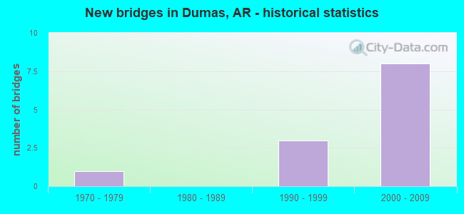
- New bridges - historical statistics
- 11970-1979
- 31990-1999
- 82000-2009


- Bridge Condition - Deck
- 22.2%Very good
- 66.7%Good
- 11.1%Fair

- Bridge Condition - Superstructure
- 44.4%Very good
- 44.4%Good
- 11.1%Poor

- Bridge Condition - Substructure
- 44.4%Very good
- 33.3%Good
- 22.2%Satisfactory

- Bridge Condition - Channel
- 16.7%Very good
- 66.7%Good
- 16.7%Satisfactory

- Bridge Condition - Culverts
- 33.3%Very good
- 66.7%Good
Find on map >> Show street view
Structure Number: 4328, Location: 2.8 M S US 65-Dumas (Lat: 33.864167, Lng: -91.528608), Route carried "on" structure: County highway 21, Year Built: 1977, Status: Open, Structure Length: 3.20m (10.50ft), Average Daily Traffic: 60 (year 2018), Truck Traffic: 2%, Average Future Daily Traffic: 327 (year 2007), Design Load: H 15, Features Intersected: Little Wagon Bayou
Minimum Vertical Clearance: 30+ m (98+ ft), Kilometerpoint: 4.168, Lanes on structure: 2, Owner: County Highway Agency, Approaching Roadway Width: 7.3m (24.0ft), Material/Design: Concrete, Design/Construction: Slab, Number Of Spans In Main Unit: 3, Length of Maximum Span: 10.7m (35.1ft), Curb-To-Curb Width: 7.9m (25.9ft), Out-to-Out Width: 8.8m (28.9ft)
Condition: Deck: Good, Superstructure: Good, Substructure: Very good, Channel: Good, Operating Rating: 49.9 metric tons, Method Used To Determine Operating Rating: Load Factor (LF), Inventory Rating: 29.9 metric tons, Method Used To Determine Inventory Rating: Load Factor (LF), Structural Evaluation: Better than present minimum criteria, Deck Geometry: Equal to present minimum criteria, Waterway Adequacy: Equal to present desirable criteria, Approach Roadway Alignment: Better than present minimum criteria, Designated Inspection Frequency: Every 24 months, Critical Feature Inspection Frequency: Every 24 months, Inspection Date: March 2020, Deck Structure Type: Concrete Cast-file-Place, Wearing Surface/Protective System: Wearing Surface: Monolithic Concrete
Find on map >> Show street view
Structure Number: 4795, Location: 1.3 Mi E US65, Mitchville (Lat: 33.926389, Lng: -91.480831), Route carried "on" structure: County highway 31, Year Built: 1998, Status: Open, Structure Length: 5.33m (17.49ft), Average Daily Traffic: 70 (year 2018), Truck Traffic: 1%, Average Future Daily Traffic: 179 (year 2017), Design Load: HS 20, Features Intersected: Canal 19
Minimum Vertical Clearance: 30+ m (98+ ft), Kilometerpoint: 3.653, Lanes on structure: 2, Owner: County Highway Agency, Approaching Roadway Width: 8.5m (27.9ft), Material/Design: Concrete, Design/Construction: Tee Beam, Number Of Spans In Main Unit: 5, Length of Maximum Span: 10.7m (35.1ft), Curb-To-Curb Width: 8.5m (27.9ft), Out-to-Out Width: 9.5m (31.2ft)
Condition: Deck: Good, Superstructure: Good, Substructure: Good, Channel: Satisfactory, Operating Rating: 54.4 metric tons, Method Used To Determine Operating Rating: Load Factor (LF), Inventory Rating: 32.7 metric tons, Method Used To Determine Inventory Rating: Load Factor (LF), Structural Evaluation: Better than present minimum criteria, Deck Geometry: Better than present minimum criteria, Waterway Adequacy: Equal to present desirable criteria, Approach Roadway Alignment: Equal to present desirable criteria, Designated Inspection Frequency: Every 24 months, Critical Feature Inspection Frequency: Every 24 months, Inspection Date: April 2020, Deck Structure Type: Concrete Cast-file-Place
Find on map >> Show street view
Structure Number: 6855, Location: 1.26 Mi E US 65-Dumas (Lat: 33.882489, Lng: -91.461931), Route carried "on" structure: US 165, Year Built: 2003, Status: Open, Structure Length: 4.79m (15.72ft), Average Daily Traffic: 4,400 (year 2018), Truck Traffic: 16%, Average Future Daily Traffic: 6,924 (year 2028), Design Load: HS 20, Features Intersected: Canal No. 19
Minimum Vertical Clearance: 30+ m (98+ ft), Kilometerpoint: 2.028, Lanes on structure: 2, Base Highway Network: Yes, Owner: State Highway Agency, Approaching Roadway Width: 11.6m (38.1ft), Material/Design: Steel continuous, Design/Construction: Stringer/Multi-beam, Number Of Spans In Main Unit: 3, Length of Maximum Span: 18.0m (59.1ft), Curb-To-Curb Width: 12.2m (40.0ft), Out-to-Out Width: 13.1m (43.0ft)
Condition: Deck: Good, Superstructure: Very good, Substructure: Good, Channel: Very good, Operating Rating: 54.4 metric tons, Method Used To Determine Operating Rating: Load Factor (LF), Inventory Rating: 32.7 metric tons, Method Used To Determine Inventory Rating: Load Factor (LF), Structural Evaluation: Better than present minimum criteria, Deck Geometry: Equal to present minimum criteria, Waterway Adequacy: Equal to present desirable criteria, Approach Roadway Alignment: Equal to present desirable criteria, Designated Inspection Frequency: Every 24 months, Critical Feature Inspection Frequency: Every 24 months, Inspection Date: January 2021, Deck Structure Type: Concrete Cast-file-Place, Wearing Surface/Protective System: Wearing Surface: Monolithic Concrete, Deck Protection: Epoxy Coated Reinforcing
Find on map >> Show street view
Structure Number: 6856, Location: 1.86 Mi E US 65-Dumas (Lat: 33.881769, Lng: -91.451589), Route carried "on" structure: US 165, Year Built: 2003, Status: Open, Structure Length: 3.97m (13.02ft), Average Daily Traffic: 4,400 (year 2018), Truck Traffic: 16%, Average Future Daily Traffic: 6,924 (year 2028), Design Load: HS 20, Features Intersected: Cypress Creek
Minimum Vertical Clearance: 30+ m (98+ ft), Kilometerpoint: 2.993, Lanes on structure: 2, Base Highway Network: Yes, Owner: State Highway Agency, Approaching Roadway Width: 11.6m (38.1ft), Material/Design: Steel continuous, Design/Construction: Stringer/Multi-beam, Number Of Spans In Main Unit: 3, Length of Maximum Span: 14.6m (47.9ft), Curb-To-Curb Width: 12.2m (40.0ft), Out-to-Out Width: 13.1m (43.0ft)
Condition: Deck: Good, Superstructure: Very good, Substructure: Very good, Channel: Good, Operating Rating: 54.4 metric tons, Method Used To Determine Operating Rating: Load Factor (LF), Inventory Rating: 32.7 metric tons, Method Used To Determine Inventory Rating: Load Factor (LF), Structural Evaluation: Equal to present desirable criteria, Deck Geometry: Equal to present minimum criteria, Waterway Adequacy: Equal to present desirable criteria, Approach Roadway Alignment: Equal to present desirable criteria, Designated Inspection Frequency: Every 24 months, Critical Feature Inspection Frequency: Every 24 months, Inspection Date: January 2021, Deck Structure Type: Concrete Cast-file-Place, Wearing Surface/Protective System: Wearing Surface: Monolithic Concrete, Deck Protection: Epoxy Coated Reinforcing
Find on map >> Show street view
Structure Number: 21014, Location: 0.01 Mi W US 65-Dumas (Lat: 33.879550, Lng: -91.483192), Route carried "on" structure: City street 23, Year Built: 1991, Status: Open, Structure Length: 1.36m (4.46ft), Average Daily Traffic: 83 (year 1987), Truck Traffic: 1%, Average Future Daily Traffic: 15,132 (year 2038), Features Intersected: Canal, Facility Carried by Structure: Red Line Road - CS
Minimum Vertical Clearance: 30+ m (98+ ft), Kilometerpoint: 0.016, Lanes on structure: 1, Owner: City or Municipal Highway Agency, Approaching Roadway Width: 6.1m (20.0ft), Material/Design: Steel, Design/Construction: Orthotropic, Number Of Spans In Main Unit: 1, Length of Maximum Span: 8.5m (27.9ft), Curb or Sidewalk Widths: Left: 0.1m (0.3ft), Right: 0.1m (0.3ft), Curb-To-Curb Width: 5.2m (17.1ft), Out-to-Out Width: 5.4m (17.7ft)
Condition: Deck: Good, Superstructure: Good, Substructure: Satisfactory, Channel: Good, Operating Rating: 54.4 metric tons, Method Used To Determine Operating Rating: Load Factor (LF), Inventory Rating: 32.7 metric tons, Method Used To Determine Inventory Rating: Load Factor (LF), Structural Evaluation: Equal to present minimum criteria, Deck Geometry: High priority of corrective action, Waterway Adequacy: Equal to present minimum criteria, Approach Roadway Alignment: Equal to present desirable criteria, Designated Inspection Frequency: Every 24 months, Critical Feature Inspection Frequency: Every 24 months, Inspection Date: December 2021, Critical Feature Inspection Date: December 2021, Deck Structure Type: Steel plate
Find on map >> Show street view
Structure Number: 213, Location: @ EWalnutLake Dr-Pickens (Lat: 33.845911, Lng: -91.482811), Route carried "on" structure: County highway 288, Year Built: 1993, Status: Posted for load, Structure Length: 2.71m (8.89ft), Average Daily Traffic: 11 (year 2018), Truck Traffic: 10%, Average Future Daily Traffic: 12 (year 2004), Features Intersected: Walnut Lake
Minimum Vertical Clearance: 30+ m (98+ ft), Kilometerpoint: 0.016, Lanes on structure: 1, Owner: County Highway Agency, Approaching Roadway Width: 6.1m (20.0ft), Material/Design: Steel continuous, Design/Construction: Orthotropic, Number Of Spans In Main Unit: 3, Length of Maximum Span: 11.2m (36.7ft), Curb-To-Curb Width: 5.1m (16.7ft), Out-to-Out Width: 5.3m (17.4ft)
Condition: Deck: Fair, Superstructure: Poor, Substructure: Satisfactory, Channel: Satisfactory, Operating Rating: 8.2 metric tons, Method Used To Determine Operating Rating: Load Factor (LF), Inventory Rating: 4.5 metric tons, Method Used To Determine Inventory Rating: Load Factor (LF), Structural Evaluation: High priority of corrective action, Deck Geometry: High priority of corrective action, Waterway Adequacy: Equal to present minimum criteria, Approach Roadway Alignment: Equal to present minimum criteria, Bridge Posting: Required (Relationship of Operating Rating to Maximum Legal Load: > 39.9% below), Designated Inspection Frequency: Every 24 months, Critical Feature Inspection Frequency: Every 24 months, Inspection Date: January 2022, Critical Feature Inspection Date: January 2022, Deck Structure Type: Steel plate, Wearing Surface/Protective System: Wearing Surface: Other
Find on map >> Show street view
Structure Number: 22708, Location: 0.2 Mi W US 65-Dumas (Lat: 33.872222, Lng: -91.483333), Route carried "on" structure: City street 7260, Year Built: 2005, Status: Open, Structure Length: 0.94m (3.08ft), Average Daily Traffic: 18 (year 2018), Truck Traffic: 1%, Average Future Daily Traffic: 1,316 (year 2008), Features Intersected: Drainage Ditch, Facility Carried by Structure: Brookhaven St-CS
Minimum Vertical Clearance: 30+ m (98+ ft), Kilometerpoint: 0.499, Lanes on structure: 2, Owner: City or Municipal Highway Agency, Approaching Roadway Width: 6.9m (22.6ft), Material/Design: Concrete, Design/Construction: Channel Beam, Number Of Spans In Main Unit: 1, Length of Maximum Span: 7.9m (25.9ft), Curb or Sidewalk Widths: Left: 0.3m (1.0ft), Right: 0.3m (1.0ft), Curb-To-Curb Width: 8.4m (27.6ft), Out-to-Out Width: 9.1m (29.9ft)
Condition: Deck: Good, Superstructure: Good, Substructure: Good, Channel: Good, Operating Rating: 54.4 metric tons, Method Used To Determine Operating Rating: Load Factor (LF), Inventory Rating: 32.7 metric tons, Method Used To Determine Inventory Rating: Load Factor (LF), Structural Evaluation: Better than present minimum criteria, Deck Geometry: Equal to present minimum criteria, Waterway Adequacy: Better than present minimum criteria, Approach Roadway Alignment: Equal to present desirable criteria, Designated Inspection Frequency: Every 24 months, Critical Feature Inspection Frequency: Every 24 months, Inspection Date: January 2021, Deck Structure Type: Concrete Precast Panels, Wearing Surface/Protective System: Wearing Surface: Monolithic Concrete
Find on map >> Show street view
Structure Number: A6966, Location: 4.7 Mi N SH 138-Perkins (Lat: 33.847058, Lng: -91.476608), Route carried "on" structure: US 65, Year Built: 2006, Status: Open, Structure Length: 7.63m (25.03ft), Average Daily Traffic: 2,150 (year 2018), Truck Traffic: 22%, Average Future Daily Traffic: 4,328 (year 2028), Design Load: HS 20, Features Intersected: Walnut Lake
Minimum Vertical Clearance: 30+ m (98+ ft), Kilometerpoint: 15.466, Lanes on structure: 2, Base Highway Network: Yes, Owner: State Highway Agency, Approaching Roadway Width: 11.6m (38.1ft), Skew: 3 degrees, Material/Design: Steel continuous, Design/Construction: Stringer/Multi-beam, Number Of Spans In Main Unit: 4, Length of Maximum Span: 21.0m (68.9ft), Curb-To-Curb Width: 11.6m (38.1ft), Out-to-Out Width: 12.5m (41.0ft)
Condition: Deck: Very good, Superstructure: Very good, Substructure: Very good, Channel: Good, Operating Rating: 54.4 metric tons, Method Used To Determine Operating Rating: Load Factor (LF), Inventory Rating: 32.7 metric tons, Method Used To Determine Inventory Rating: Load Factor (LF), Structural Evaluation: Equal to present desirable criteria, Deck Geometry: Better than present minimum criteria, Waterway Adequacy: Equal to present desirable criteria, Approach Roadway Alignment: Equal to present desirable criteria, Designated Inspection Frequency: Every 24 months, Critical Feature Inspection Frequency: Every 24 months, Inspection Date: April 2020, Deck Structure Type: Concrete Cast-file-Place, Wearing Surface/Protective System: Wearing Surface: Monolithic Concrete
Find on map >> Show street view
Structure Number: B6966, Location: 4.7 Mi N SH 138-Perkins (Lat: 33.846958, Lng: -91.476308), Route carried "on" structure: US 65, Year Built: 2006, Status: Open, Structure Length: 7.63m (25.03ft), Average Daily Traffic: 2,150 (year 2018), Truck Traffic: 22%, Average Future Daily Traffic: 4,328 (year 2028), Design Load: HS 20, Features Intersected: Walnut Lake
Minimum Vertical Clearance: 30+ m (98+ ft), Kilometerpoint: 15.482, Lanes on structure: 2, Base Highway Network: Yes, Owner: State Highway Agency, Approaching Roadway Width: 11.6m (38.1ft), Skew: 3 degrees, Material/Design: Steel continuous, Design/Construction: Stringer/Multi-beam, Number Of Spans In Main Unit: 4, Length of Maximum Span: 21.0m (68.9ft), Curb-To-Curb Width: 11.6m (38.1ft), Out-to-Out Width: 12.5m (41.0ft)
Condition: Deck: Very good, Superstructure: Very good, Substructure: Very good, Channel: Good, Operating Rating: 54.4 metric tons, Method Used To Determine Operating Rating: Load Factor (LF), Inventory Rating: 32.7 metric tons, Method Used To Determine Inventory Rating: Load Factor (LF), Structural Evaluation: Equal to present desirable criteria, Deck Geometry: Better than present minimum criteria, Waterway Adequacy: Equal to present desirable criteria, Approach Roadway Alignment: Equal to present desirable criteria, Designated Inspection Frequency: Every 24 months, Critical Feature Inspection Frequency: Every 24 months, Inspection Date: April 2020, Deck Structure Type: Concrete Cast-file-Place, Wearing Surface/Protective System: Wearing Surface: Monolithic Concrete
Find on map >> Show street view
Structure Number: X1144, Location: 1.0 Mi N US 165-Dumas (Lat: 33.898069, Lng: -91.489150), Route carried "on" structure: US 65, Year Built: 2004, Status: Open, Structure Length: 0.80m (2.62ft), Average Daily Traffic: 9,647 (year 2018), Truck Traffic: 22%, Average Future Daily Traffic: 12,695 (year 2028), Design Load: H 20, Features Intersected: Ditch
Minimum Vertical Clearance: 30+ m (98+ ft), Kilometerpoint: 9.608, Lanes on structure: 5, Base Highway Network: Yes, Owner: State Highway Agency, Approaching Roadway Width: 17.7m (58.1ft), Skew: 4 degrees, Material/Design: Concrete, Design/Construction: Culvert, Number Of Spans In Main Unit: 2, Length of Maximum Span: 4.0m (13.1ft)
Condition: Channel: Very good, Culverts: Good, Operating Rating: 29.0 metric tons, Method Used To Determine Operating Rating: Load Factor (LF), Inventory Rating: 17.2 metric tons, Method Used To Determine Inventory Rating: Load Factor (LF), Structural Evaluation: Meets minimum limits, Waterway Adequacy: Equal to present desirable criteria, Approach Roadway Alignment: Equal to present desirable criteria, Designated Inspection Frequency: Every 24 months, Critical Feature Inspection Frequency: Every 24 months, Inspection Date: Febuary 2022
Find on map >> Show street view
Structure Number: X1215, Location: 0.40 Mi S US 165-Dumas (Lat: 33.868589, Lng: -91.480619), Route carried "on" structure: US 65, Year Built: 2004, Status: Open, Structure Length: 0.79m (2.59ft), Average Daily Traffic: 11,844 (year 2018), Truck Traffic: 22%, Average Future Daily Traffic: 15,132 (year 2038), Design Load: H 20, Features Intersected: Ditch
Minimum Vertical Clearance: 30+ m (98+ ft), Kilometerpoint: 13.036, Lanes on structure: 5, Base Highway Network: Yes, Owner: State Highway Agency, Approaching Roadway Width: 21.5m (70.5ft), Material/Design: Concrete, Design/Construction: Culvert, Number Of Spans In Main Unit: 3, Length of Maximum Span: 2.4m (7.9ft)
Condition: Channel: Good, Culverts: Good, Operating Rating: 49.9 metric tons, Method Used To Determine Operating Rating: Load Factor (LF), Inventory Rating: 29.9 metric tons, Method Used To Determine Inventory Rating: Load Factor (LF), Structural Evaluation: Better than present minimum criteria, Waterway Adequacy: Equal to present desirable criteria, Approach Roadway Alignment: Equal to present desirable criteria, Designated Inspection Frequency: Every 24 months, Critical Feature Inspection Frequency: Every 24 months, Inspection Date: Febuary 2022
Find on map >> Show street view
Structure Number: X1309, Location: 1.4 Mi W US 65-Dumas (Lat: 33.891078, Lng: -91.500550), Route carried "on" structure: State highway 54, Year Built: 2007, Status: Open, Structure Length: 0.62m (2.03ft), Average Daily Traffic: 2,510 (year 2018), Truck Traffic: 6%, Average Future Daily Traffic: 3,231 (year 2028), Features Intersected: Ditch #6
Minimum Vertical Clearance: 30+ m (98+ ft), Kilometerpoint: 2.398, Lanes on structure: 3, Owner: State Highway Agency, Approaching Roadway Width: 11.0m (36.1ft), Material/Design: Aluminum, Iron, Design/Construction: Culvert, Number Of Spans In Main Unit: 1, Length of Maximum Span: 6.1m (20.0ft), Curb or Sidewalk Widths: Left: 0.3m (1.0ft), Right: 0.3m (1.0ft)
Condition: Channel: Good, Culverts: Very good, Operating Rating: 54.4 metric tons, Method Used To Determine Operating Rating: Load Factor (LF), Inventory Rating: 32.7 metric tons, Method Used To Determine Inventory Rating: Load Factor (LF), Structural Evaluation: Equal to present desirable criteria, Waterway Adequacy: Equal to present desirable criteria, Approach Roadway Alignment: Better than present minimum criteria, Length Of Structure Improvement: 2.29m (7.51ft), Designated Inspection Frequency: Every 24 months, Critical Feature Inspection Frequency: Every 24 months, Inspection Date: January 2021