Bridge Statistics for Dunkerton, Iowa (IA)
Condition, Traffic, Stress, Structural Evaluation, Project Costs
- National Bridge Inventory (NBI) Statistics
- 19Number of bridges
- 243ft / 74.4mTotal length
- 12,735Total average daily traffic
- 1,986Total average daily truck traffic
- 12,735Total future (year 2038) average daily traffic
- National Bridge Inventory (NBI) Registered Bridges for Dunkerton
- No street view available for this location
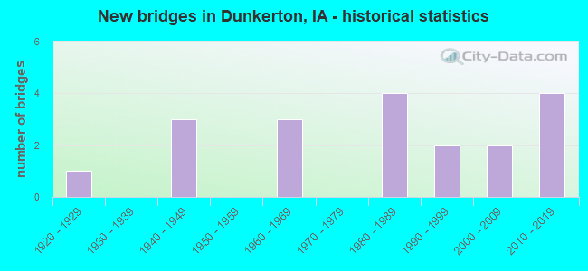
- New bridges - historical statistics
- 11920-1929
- 31940-1949
- 31960-1969
- 41980-1989
- 21990-1999
- 22000-2009
- 42010-2019

- Bridge Condition - Deck
- 18.8%Very good
- 31.3%Good
- 18.8%Satisfactory
- 18.8%Fair
- 6.3%Poor
- 6.3%Failed

- Bridge Condition - Superstructure
- 25.0%Very good
- 37.5%Good
- 25.0%Satisfactory
- 6.3%Fair
- 6.3%Failed

- Bridge Condition - Substructure
- 31.3%Very good
- 31.3%Good
- 18.8%Satisfactory
- 6.3%Fair
- 6.3%Poor
- 6.3%Failed

- Bridge Condition - Channel
- 5.3%Excellent
- 36.8%Very good
- 47.4%Good
- 5.3%Satisfactory
- 5.3%Fair

- Bridge Condition - Culverts
- 33.3%Very good
- 66.7%Good
Find on map >> Show street view
Structure Number: 4271, Location: 0.3 mi. N of Jct. SR C66 (Lat: 42.572806, Lng: -92.160753), Route carried "on" structure: State highway 281, Year Built: 2006, Status: Open, Structure Length: 6.52m (21.39ft), Average Daily Traffic: 1,690 (year 2020), Truck Traffic: 13%, Average Future Daily Traffic: 1,690 (year 2040), Design Load: HS 20, Features Intersected: CRANE CREEK
Minimum Vertical Clearance: 30+ m (98+ ft), Kilometerpoint: 17.262, Lanes on structure: 2, Base Highway Network: Yes, Owner: State Highway Agency, Approaching Roadway Width: 12.2m (40.0ft), Material/Design: Concrete continuous, Design/Construction: Slab, Number Of Spans In Main Unit: 5, Length of Maximum Span: 14.3m (46.9ft), Curb-To-Curb Width: 12.2m (40.0ft), Out-to-Out Width: 13.1m (43.0ft)
Condition: Deck: Good, Superstructure: Good, Substructure: Very good, Channel: Very good, Operating Rating: 85.7 metric tons, Method Used To Determine Operating Rating: Load Factor (LF), Inventory Rating: 51.4 metric tons, Method Used To Determine Inventory Rating: Load Factor (LF), Structural Evaluation: Better than present minimum criteria, Deck Geometry: Better than present minimum criteria, Waterway Adequacy: Equal to present desirable criteria, Approach Roadway Alignment: Equal to present desirable criteria, Designated Inspection Frequency: Every 24 months, Inspection Date: November 2020, Deck Structure Type: Concrete Cast-file-Place, Wearing Surface/Protective System: Wearing Surface: Monolithic Concrete, Deck Protection: Epoxy Coated Reinforcing
Find on map >> Show street view
Structure Number: 15131, Location: 2.3 MI N OF JCT SR D20 (Lat: 42.530547, Lng: -92.161142), Route carried "on" structure: State highway 281, Year Built: 2014, Status: Open, Structure Length: 0.88m (2.89ft), Average Daily Traffic: 2,390 (year 2020), Truck Traffic: 14%, Average Future Daily Traffic: 2,390 (year 2041), Design Load: HL 93, Features Intersected: POYNER CREEK
Minimum Vertical Clearance: 30+ m (98+ ft), Kilometerpoint: 12.569, Lanes on structure: 2, Base Highway Network: Yes, Owner: State Highway Agency, Approaching Roadway Width: 13.4m (44.0ft), Skew: 3 degrees, Material/Design: Concrete continuous, Design/Construction: Culvert, Number Of Spans In Main Unit: 2, Length of Maximum Span: 4.3m (14.1ft)
Condition: Channel: Excellent, Culverts: Very good, Operating Rating: 42.1 metric tons, Method Used To Determine Operating Rating: Assigned ratings based on Load and Resistance Factor Design (LRFD) reported by rating factor (RF) using HL93 loadings, Inventory Rating: 32.4 metric tons, Method Used To Determine Inventory Rating: Assigned ratings based on Load and Resistance Factor Design (LRFD) reported by rating factor (RF) using HL93 loadings, Structural Evaluation: Equal to present desirable criteria, Waterway Adequacy: Superior to present desirable criteria, Approach Roadway Alignment: Equal to present desirable criteria, Designated Inspection Frequency: Every 24 months, Inspection Date: June 2021
Find on map >> Show street view
Structure Number: 7548, Location: 89-11-03-01-10 (Lat: 42.555314, Lng: -92.129108), Route carried "on" structure: County highway , Year Built: 1920, Year Reconstructed: 1969, Status: Temporarily open, Structure Length: 0.64m (2.10ft), Average Daily Traffic: 50 (year 2017), Average Future Daily Traffic: 50 (year 2040), Features Intersected: TRIB TO WAPSIPINICON RVR, Facility Carried by Structure: E BIG ROCK RD
Minimum Vertical Clearance: 30+ m (98+ ft), Kilometerpoint: 15.895, Lanes on structure: 2, Owner: County Highway Agency, Approaching Roadway Width: 7.9m (25.9ft), Material/Design: Steel continuous, Design/Construction: Stringer/Multi-beam, Number Of Spans In Main Unit: 2, Length of Maximum Span: 6.1m (20.0ft), Curb-To-Curb Width: 7.2m (23.6ft), Out-to-Out Width: 7.4m (24.3ft)
Condition: Deck: Satisfactory, Superstructure: Satisfactory, Substructure: Satisfactory, Channel: Good, Operating Rating: 48.8 metric tons, Method Used To Determine Operating Rating: Allowable Stress (AS), Inventory Rating: 28.4 metric tons, Method Used To Determine Inventory Rating: Allowable Stress (AS), Structural Evaluation: Equal to present minimum criteria, Deck Geometry: Somewhat better than minimum adequacy, Waterway Adequacy: Better than present minimum criteria, Approach Roadway Alignment: Better than present minimum criteria, Length Of Structure Improvement: 4.00m (13.12ft), Designated Inspection Frequency: Every 24 months, Inspection Date: November 2020, Bridge Improvement Cost: $40,000, Roadway Improvement Cost: $10,000, Deck Structure Type: Concrete Cast-file-Place, Wearing Surface/Protective System: Wearing Surface: Monolithic Concrete
Find on map >> Show street view
Structure Number: 75491, Location: 89-11-07-01-10 (Lat: 42.541461, Lng: -92.196369), Route carried "on" structure: County highway , Year Built: 1986, Status: Open, Structure Length: 1.55m (5.09ft), Average Daily Traffic: 60 (year 2017), Average Future Daily Traffic: 60 (year 2038), Design Load: H 20, Features Intersected: TRIB TO ELK RUN CREEK, Facility Carried by Structure: E AIRLINE HWY
Minimum Vertical Clearance: 30+ m (98+ ft), Kilometerpoint: 7.416, Lanes on structure: 2, Owner: County Highway Agency, Approaching Roadway Width: 6.7m (22.0ft), Material/Design: Prestressed concrete, Design/Construction: Tee Beam, Number Of Spans In Main Unit: 1, Length of Maximum Span: 15.2m (49.9ft), Curb-To-Curb Width: 7.8m (25.6ft), Out-to-Out Width: 7.8m (25.6ft)
Condition: Deck: Good, Superstructure: Good, Substructure: Satisfactory, Channel: Good, Operating Rating: 49.6 metric tons, Method Used To Determine Operating Rating: Load Factor (LF), Inventory Rating: 33.3 metric tons, Method Used To Determine Inventory Rating: Load Factor (LF), Structural Evaluation: Equal to present minimum criteria, Deck Geometry: Equal to present minimum criteria, Waterway Adequacy: Equal to present minimum criteria, Approach Roadway Alignment: Better than present minimum criteria, Designated Inspection Frequency: Every 48 months, Inspection Date: November 2018, Deck Structure Type: Concrete Precast Panels, Wearing Surface/Protective System: Wearing Surface: Monolithic Concrete
Find on map >> Show street view
Structure Number: 75551, Location: 89-11-17-03-10 (Lat: 42.523108, Lng: -92.165906), Route carried "on" structure: County highway , Year Built: 1987, Status: Open, Structure Length: 1.25m (4.10ft), Average Daily Traffic: 60 (year 2021), Average Future Daily Traffic: 60 (year 2038), Design Load: HS 20, Features Intersected: POYNER CREEK, Facility Carried by Structure: BARCLAY RD
Minimum Vertical Clearance: 30+ m (98+ ft), Kilometerpoint: 1.226, Lanes on structure: 2, Owner: County Highway Agency, Approaching Roadway Width: 7.9m (25.9ft), Skew: 1 degrees, Material/Design: Prestressed concrete, Design/Construction: Tee Beam, Number Of Spans In Main Unit: 1, Length of Maximum Span: 12.2m (40.0ft), Curb-To-Curb Width: 8.4m (27.6ft), Out-to-Out Width: 8.5m (27.9ft)
Condition: Deck: Good, Superstructure: Good, Substructure: Good, Channel: Good, Operating Rating: 55.1 metric tons, Method Used To Determine Operating Rating: Load Factor (LF), Inventory Rating: 35.9 metric tons, Method Used To Determine Inventory Rating: Load Factor (LF), Structural Evaluation: Better than present minimum criteria, Deck Geometry: Equal to present minimum criteria, Waterway Adequacy: Equal to present minimum criteria, Approach Roadway Alignment: Better than present minimum criteria, Designated Inspection Frequency: Every 48 months, Inspection Date: November 2018, Deck Structure Type: Concrete Cast-file-Place, Wearing Surface/Protective System: Wearing Surface: Monolithic Concrete
Find on map >> Show street view
Structure Number: 75561, Location: 89-11-20-01-10 (Lat: 42.512261, Lng: -92.173242), Route carried "on" structure: County highway , Year Built: 2014, Status: Open, Structure Length: 1.23m (4.04ft), Average Daily Traffic: 30 (year 2021), Average Future Daily Traffic: 30 (year 2038), Design Load: HL 93, Features Intersected: POYNER CREEK, Facility Carried by Structure: NEWELL ST
Minimum Vertical Clearance: 30+ m (98+ ft), Kilometerpoint: 6.331, Lanes on structure: 2, Owner: County Highway Agency, Approaching Roadway Width: 7.3m (24.0ft), Material/Design: Steel, Design/Construction: Stringer/Multi-beam, Number Of Spans In Main Unit: 1, Length of Maximum Span: 11.9m (39.0ft), Curb-To-Curb Width: 9.1m (29.9ft), Out-to-Out Width: 9.3m (30.5ft)
Condition: Deck: Very good, Superstructure: Very good, Substructure: Very good, Channel: Very good, Operating Rating: 48.3 metric tons, Method Used To Determine Operating Rating: Load and Resistance Factor Rating (LRFR) rating reported by rating factor(RF) method using HL-93 loadings, Inventory Rating: 37.3 metric tons, Method Used To Determine Inventory Rating: Load and Resistance Factor Rating (LRFR) rating reported by rating factor(RF) method using HL-93 loadings, Structural Evaluation: Equal to present desirable criteria, Deck Geometry: Better than present minimum criteria, Waterway Adequacy: Equal to present desirable criteria, Approach Roadway Alignment: Equal to present desirable criteria, Designated Inspection Frequency: Every 48 months, Inspection Date: November 2018, Deck Structure Type: Concrete Cast-file-Place, Wearing Surface/Protective System: Wearing Surface: Monolithic Concrete
Find on map >> Show street view
Structure Number: 76011, Location: 2.2 MI E. OF S.R. C57 (Lat: 42.635053, Lng: -92.144644), Route carried "on" structure: State highway 281, Year Built: 1989, Status: Open, Structure Length: 11.86m (38.91ft), Average Daily Traffic: 1,050 (year 2020), Truck Traffic: 22%, Average Future Daily Traffic: 1,050 (year 2040), Design Load: HS 20, Features Intersected: WAPSIPINICON RIVER
Minimum Vertical Clearance: 30+ m (98+ ft), Kilometerpoint: 25.370, Lanes on structure: 2, Base Highway Network: Yes, Owner: State Highway Agency, Approaching Roadway Width: 12.2m (40.0ft), Material/Design: Prestressed concrete, Design/Construction: Stringer/Multi-beam, Number Of Spans In Main Unit: 4, Length of Maximum Span: 29.6m (97.1ft), Curb-To-Curb Width: 11.0m (36.1ft), Out-to-Out Width: 11.9m (39.0ft)
Condition: Deck: Satisfactory, Superstructure: Very good, Substructure: Good, Channel: Very good, Operating Rating: 90.5 metric tons, Method Used To Determine Operating Rating: Load Factor (LF), Inventory Rating: 44.5 metric tons, Method Used To Determine Inventory Rating: Load Factor (LF), Structural Evaluation: Better than present minimum criteria, Deck Geometry: Equal to present minimum criteria, Waterway Adequacy: Better than present minimum criteria, Approach Roadway Alignment: Better than present minimum criteria, Designated Inspection Frequency: Every 24 months, Underwater Inspection Frequency: Every 48 months, Inspection Date: October 2020, Underwater Inspection Date: October 2020, Deck Structure Type: Concrete Cast-file-Place, Wearing Surface/Protective System: Wearing Surface: Monolithic Concrete, Deck Protection: Epoxy Coated Reinforcing
Find on map >> Show street view
Structure Number: 76031, Location: 90-11-07-01-10 (Lat: 42.628392, Lng: -92.198247), Route carried "on" structure: County highway , Year Built: 2018, Status: Open, Structure Length: 1.23m (4.04ft), Average Daily Traffic: 15 (year 2021), Average Future Daily Traffic: 15 (year 2040), Design Load: HS 20, Features Intersected: TRIB TO CRANE CREEK, Facility Carried by Structure: E GRESHAM RD
Minimum Vertical Clearance: 30+ m (98+ ft), Kilometerpoint: 11.430, Lanes on structure: 2, Owner: County Highway Agency, Approaching Roadway Width: 7.9m (25.9ft), Material/Design: Steel, Design/Construction: Stringer/Multi-beam, Number Of Spans In Main Unit: 1, Length of Maximum Span: 11.9m (39.0ft), Curb-To-Curb Width: 9.1m (29.9ft), Out-to-Out Width: 9.3m (30.5ft)
Condition: Deck: Very good, Superstructure: Very good, Substructure: Very good, Channel: Very good, Operating Rating: 48.3 metric tons, Method Used To Determine Operating Rating: Load and Resistance Factor Rating (LRFR) rating reported by rating factor(RF) method using HL-93 loadings, Inventory Rating: 37.3 metric tons, Method Used To Determine Inventory Rating: Load and Resistance Factor Rating (LRFR) rating reported by rating factor(RF) method using HL-93 loadings, Structural Evaluation: Equal to present desirable criteria, Deck Geometry: Better than present minimum criteria, Waterway Adequacy: Better than present minimum criteria, Approach Roadway Alignment: Equal to present desirable criteria, Designated Inspection Frequency: Every 24 months, Inspection Date: November 2020, Deck Structure Type: Concrete Cast-file-Place, Wearing Surface/Protective System: Wearing Surface: Monolithic Concrete
Find on map >> Show street view
Structure Number: 76035, Location: 90-11-10-03 (Lat: 42.613564, Lng: -92.128522), Route carried "on" structure: County highway , Year Built: 1969, Status: Open, Structure Length: 10.61m (34.81ft), Average Daily Traffic: 1,520 (year 2021), Truck Traffic: 17%, Average Future Daily Traffic: 1,520 (year 2040), Design Load: H 20, Features Intersected: WAPSIPINCON RIVER, Facility Carried by Structure: E CEDAR-WAPSI RD
Minimum Vertical Clearance: 30+ m (98+ ft), Kilometerpoint: 17.168, Lanes on structure: 2, Owner: County Highway Agency, Approaching Roadway Width: 9.8m (32.2ft), Material/Design: Steel continuous, Design/Construction: Stringer/Multi-beam, Number Of Spans In Main Unit: 4, Length of Maximum Span: 29.9m (98.1ft), Curb-To-Curb Width: 8.5m (27.9ft), Out-to-Out Width: 9.1m (29.9ft)
Condition: Deck: Satisfactory, Superstructure: Satisfactory, Substructure: Satisfactory, Channel: Good, Operating Rating: 39.4 metric tons, Method Used To Determine Operating Rating: Allowable Stress (AS), Inventory Rating: 27.3 metric tons, Method Used To Determine Inventory Rating: Allowable Stress (AS), Structural Evaluation: Equal to present minimum criteria, Deck Geometry: Somewhat better than minimum adequacy, Waterway Adequacy: Better than present minimum criteria, Approach Roadway Alignment: Better than present minimum criteria, Length Of Structure Improvement: 34.80m (114.17ft), Designated Inspection Frequency: Every 24 months, Underwater Inspection Frequency: Every 60 months, Inspection Date: September 2020, Underwater Inspection Date: August 2020, Bridge Improvement Cost: $200,000, Roadway Improvement Cost: $100,000, Deck Structure Type: Concrete Cast-file-Place, Wearing Surface/Protective System: Wearing Surface: Monolithic Concrete
Find on map >> Show street view
Structure Number: 76061, Location: 1.0 mi. S of Jct. SR C57 (Lat: 42.598483, Lng: -92.160694), Route carried "on" structure: State highway 281, Year Built: 1995, Status: Open, Structure Length: 0.70m (2.30ft), Average Daily Traffic: 1,050 (year 2020), Truck Traffic: 22%, Average Future Daily Traffic: 1,050 (year 2040), Design Load: HS 20, Features Intersected: STREAM
Minimum Vertical Clearance: 30+ m (98+ ft), Kilometerpoint: 20.114, Lanes on structure: 2, Base Highway Network: Yes, Owner: State Highway Agency, Approaching Roadway Width: 10.4m (34.1ft), Skew: 4 degrees, Material/Design: Concrete continuous, Design/Construction: Culvert, Number Of Spans In Main Unit: 1, Length of Maximum Span: 4.9m (16.1ft)
Condition: Channel: Very good, Culverts: Good, Operating Rating: 43.6 metric tons, Method Used To Determine Operating Rating: Load Factor (LF), Inventory Rating: 26.1 metric tons, Method Used To Determine Inventory Rating: Load Factor (LF), Structural Evaluation: Equal to present minimum criteria, Waterway Adequacy: Equal to present desirable criteria, Approach Roadway Alignment: Equal to present desirable criteria, Designated Inspection Frequency: Every 24 months, Inspection Date: April 2020, Deck Structure Type: Concrete Cast-file-Place, Wearing Surface/Protective System: Wearing Surface: Monolithic Concrete
Find on map >> Show street view
Structure Number: 76076, Location: 90-11-21-04-10 (Lat: 42.595806, Lng: -92.150881), Route carried "on" structure: County highway , Year Built: 1992, Status: Open, Structure Length: 1.31m (4.30ft), Average Daily Traffic: 30 (year 2021), Average Future Daily Traffic: 30 (year 2040), Design Load: HS 20, Features Intersected: TRIB TO CRANE CREK, Facility Carried by Structure: OWEN RD
Minimum Vertical Clearance: 30+ m (98+ ft), Kilometerpoint: 0.463, Lanes on structure: 2, Owner: County Highway Agency, Approaching Roadway Width: 7.3m (24.0ft), Material/Design: Steel, Design/Construction: Stringer/Multi-beam, Number Of Spans In Main Unit: 1, Length of Maximum Span: 12.8m (42.0ft), Curb-To-Curb Width: 7.3m (24.0ft), Out-to-Out Width: 7.6m (24.9ft)
Condition: Deck: Good, Superstructure: Good, Substructure: Good, Channel: Good, Operating Rating: 29.3 metric tons, Method Used To Determine Operating Rating: Allowable Stress (AS), Inventory Rating: 24.4 metric tons, Method Used To Determine Inventory Rating: Allowable Stress (AS), Structural Evaluation: Equal to present minimum criteria, Deck Geometry: Equal to present minimum criteria, Waterway Adequacy: Better than present minimum criteria, Approach Roadway Alignment: Better than present minimum criteria, Designated Inspection Frequency: Every 24 months, Inspection Date: November 2020, Deck Structure Type: Wood or Timber, Wearing Surface/Protective System: Wearing Surface: Wood or Timber
Find on map >> Show street view
Structure Number: 7609, Location: 90-11-23-01 (Lat: 42.597708, Lng: -92.117756), Route carried "on" structure: County highway , Year Built: 1945, Status: Closed, Structure Length: 4.18m (13.71ft), Average Daily Traffic: 35 (year 2017), Truck Traffic: 23%, Average Future Daily Traffic: 35 (year 2040), Features Intersected: WAPSIPINICON RIVER, Facility Carried by Structure: E BENNINGTON RD
Minimum Vertical Clearance: 3.86m (12.66ft), Kilometerpoint: 16.457, Lanes on structure: 1, Owner: County Highway Agency, Approaching Roadway Width: 7.3m (24.0ft), Material/Design: Steel, Design/Construction: Truss - Thru, Number Of Spans In Main Unit: 1, Number Of Approach Spans: 3, Length of Maximum Span: 24.4m (80.1ft), Curb-To-Curb Width: 4.9m (16.1ft), Out-to-Out Width: 5.2m (17.1ft)
Condition: Deck: Failed, Superstructure: Failed, Substructure: Failed, Channel: Fair, Waterway Adequacy: Better than present minimum criteria, Approach Roadway Alignment: High priority of corrective action, Bridge Posting: Required (Relationship of Operating Rating to Maximum Legal Load: > 39.9% below), Length Of Structure Improvement: 13.70m (44.95ft), Designated Inspection Frequency: Every 24 months, Critical Feature Inspection Frequency: Every 24 months, Inspection Date: September 2020, Critical Feature Inspection Date: October 2016, Bridge Improvement Cost: $20,000, Roadway Improvement Cost: $10,000, Deck Structure Type: Wood or Timber, Wearing Surface/Protective System: Wearing Surface: Wood or Timber
Find on map >> Show street view
Structure Number: 76121, Location: 90-11-27-02-10 (Lat: 42.575744, Lng: -92.141119), Route carried "on" structure: County highway , Year Built: 2014, Status: Open, Structure Length: 6.14m (20.14ft), Average Daily Traffic: 40 (year 2021), Average Future Daily Traffic: 40 (year 2038), Design Load: HL 93, Features Intersected: CRANE CREEK, Facility Carried by Structure: N NESBIT RD
Minimum Vertical Clearance: 30+ m (98+ ft), Kilometerpoint: 8.705, Lanes on structure: 2, Owner: County Highway Agency, Approaching Roadway Width: 7.3m (24.0ft), Skew: 1 degrees, Material/Design: Prestressed concrete, Design/Construction: Stringer/Multi-beam, Number Of Spans In Main Unit: 3, Length of Maximum Span: 22.3m (73.2ft), Curb-To-Curb Width: 7.5m (24.6ft), Out-to-Out Width: 8.3m (27.2ft)
Condition: Deck: Very good, Superstructure: Very good, Substructure: Very good, Channel: Very good, Operating Rating: 61.6 metric tons, Method Used To Determine Operating Rating: Load and Resistance Factor Rating (LRFR) rating reported by rating factor(RF) method using HL-93 loadings, Inventory Rating: 47.6 metric tons, Method Used To Determine Inventory Rating: Load and Resistance Factor Rating (LRFR) rating reported by rating factor(RF) method using HL-93 loadings, Structural Evaluation: Equal to present desirable criteria, Deck Geometry: Equal to present minimum criteria, Waterway Adequacy: Equal to present desirable criteria, Approach Roadway Alignment: Equal to present desirable criteria, Designated Inspection Frequency: Every 48 months, Inspection Date: November 2018, Deck Structure Type: Concrete Cast-file-Place, Wearing Surface/Protective System: Wearing Surface: Monolithic Concrete
Find on map >> Show street view
Structure Number: 7613, Location: 90-11-29-02-10 (Lat: 42.576439, Lng: -92.180528), Route carried "on" structure: County highway , Year Built: 1948, Status: Posted for load-capacity, Structure Length: 5.58m (18.31ft), Average Daily Traffic: 60 (year 2017), Average Future Daily Traffic: 60 (year 2040), Features Intersected: CRANE CREEK, Facility Carried by Structure: N PILOT GROVE RD
Minimum Vertical Clearance: 30+ m (98+ ft), Kilometerpoint: 8.744, Lanes on structure: 2, Owner: County Highway Agency, Approaching Roadway Width: 9.1m (29.9ft), Material/Design: Steel, Design/Construction: Stringer/Multi-beam, Number Of Spans In Main Unit: 6, Length of Maximum Span: 9.1m (29.9ft), Curb-To-Curb Width: 5.4m (17.7ft), Out-to-Out Width: 5.9m (19.4ft)
Condition: Deck: Fair, Superstructure: Good, Substructure: Good, Channel: Good, Operating Rating: 36.3 metric tons, Method Used To Determine Operating Rating: Load Factor (LF), Inventory Rating: 21.7 metric tons, Method Used To Determine Inventory Rating: Load Factor (LF), Structural Evaluation: Equal to present minimum criteria, Deck Geometry: High priority of corrective action, Waterway Adequacy: Better than present minimum criteria, Approach Roadway Alignment: Better than present minimum criteria, Bridge Posting: Required (Relationship of Operating Rating to Maximum Legal Load: 0.1 - 9.9% below), Length Of Structure Improvement: 21.00m (68.90ft), Designated Inspection Frequency: Every 24 months, Inspection Date: November 2020, Bridge Improvement Cost: $450,000, Roadway Improvement Cost: $15,000, Deck Structure Type: Concrete Cast-file-Place, Wearing Surface/Protective System: Wearing Surface: Monolithic Concrete
Find on map >> Show street view
Structure Number: 7615, Location: 90-11-35-03 (Lat: 42.569261, Lng: -92.108806), Route carried "on" structure: County highway , Year Built: 1964, Status: Open, Structure Length: 10.61m (34.81ft), Average Daily Traffic: 500 (year 2021), Truck Traffic: 15%, Average Future Daily Traffic: 500 (year 2040), Design Load: H 20, Features Intersected: WAPSIPINICON RIVER, Facility Carried by Structure: E DUNKERTON RD
Minimum Vertical Clearance: 30+ m (98+ ft), Kilometerpoint: 17.429, Lanes on structure: 2, Owner: County Highway Agency, Approaching Roadway Width: 12.2m (40.0ft), Material/Design: Steel continuous, Design/Construction: Stringer/Multi-beam, Number Of Spans In Main Unit: 4, Length of Maximum Span: 29.9m (98.1ft), Curb-To-Curb Width: 8.5m (27.9ft), Out-to-Out Width: 9.9m (32.5ft)
Condition: Deck: Poor, Superstructure: Satisfactory, Substructure: Good, Channel: Good, Operating Rating: 44.4 metric tons, Method Used To Determine Operating Rating: Allowable Stress (AS), Inventory Rating: 27.8 metric tons, Method Used To Determine Inventory Rating: Allowable Stress (AS), Structural Evaluation: Equal to present minimum criteria, Deck Geometry: Somewhat better than minimum adequacy, Waterway Adequacy: Better than present minimum criteria, Approach Roadway Alignment: Better than present minimum criteria, Length Of Structure Improvement: 34.80m (114.17ft), Designated Inspection Frequency: Every 24 months, Inspection Date: September 2020, Bridge Improvement Cost: $200,000, Roadway Improvement Cost: $150,000, Deck Structure Type: Concrete Cast-file-Place, Wearing Surface/Protective System: Wearing Surface: Monolithic Concrete
Find on map >> Show street view
Structure Number: 7616, Location: 90-11-35-04-10 (Lat: 42.562319, Lng: -92.116478), Route carried "on" structure: County highway , Year Built: 1940, Status: Temporarily open, Structure Length: 0.73m (2.40ft), Average Daily Traffic: 45 (year 2017), Average Future Daily Traffic: 45 (year 2040), Features Intersected: TRIB TO WAPSIPINICON RVR, Facility Carried by Structure: RICE RD
Minimum Vertical Clearance: 30+ m (98+ ft), Kilometerpoint: 4.392, Lanes on structure: 2, Owner: County Highway Agency, Approaching Roadway Width: 7.3m (24.0ft), Material/Design: Steel continuous, Design/Construction: Stringer/Multi-beam, Number Of Spans In Main Unit: 2, Length of Maximum Span: 3.7m (12.1ft), Curb-To-Curb Width: 6.0m (19.7ft), Out-to-Out Width: 6.1m (20.0ft)
Condition: Deck: Fair, Superstructure: Satisfactory, Substructure: Poor, Channel: Good, Operating Rating: 29.5 metric tons, Method Used To Determine Operating Rating: Allowable Stress (AS), Inventory Rating: 23.9 metric tons, Method Used To Determine Inventory Rating: Allowable Stress (AS), Structural Evaluation: Meets minimum limits, Deck Geometry: Meets minimum limits, Waterway Adequacy: Better than present minimum criteria, Approach Roadway Alignment: Better than present minimum criteria, Length Of Structure Improvement: 4.00m (13.12ft), Designated Inspection Frequency: Every 24 months, Inspection Date: November 2020, Bridge Improvement Cost: $60,000, Roadway Improvement Cost: $10,000, Deck Structure Type: Concrete Cast-file-Place, Wearing Surface/Protective System: Wearing Surface: Monolithic Concrete
Find on map >> Show street view
Structure Number: 76281, Location: 90-12-13-01-10 (Lat: 42.613917, Lng: -92.201803), Route carried "on" structure: County highway , Year Built: 2007, Status: Open, Structure Length: 2.74m (8.99ft), Average Daily Traffic: 1,930 (year 2021), Truck Traffic: 17%, Average Future Daily Traffic: 1,930 (year 2038), Design Load: HS 20, Features Intersected: TRIB TO CRANE CREEK, Facility Carried by Structure: E CEDAR-WAPSI RD
Minimum Vertical Clearance: 30+ m (98+ ft), Kilometerpoint: 11.156, Lanes on structure: 2, Owner: County Highway Agency, Approaching Roadway Width: 9.1m (29.9ft), Material/Design: Concrete continuous, Design/Construction: Slab, Number Of Spans In Main Unit: 3, Length of Maximum Span: 10.4m (34.1ft), Curb-To-Curb Width: 9.3m (30.5ft), Out-to-Out Width: 10.1m (33.1ft)
Condition: Deck: Good, Superstructure: Good, Substructure: Very good, Channel: Very good, Operating Rating: 75.9 metric tons, Method Used To Determine Operating Rating: Load Factor (LF), Inventory Rating: 45.4 metric tons, Method Used To Determine Inventory Rating: Load Factor (LF), Structural Evaluation: Better than present minimum criteria, Deck Geometry: Somewhat better than minimum adequacy, Waterway Adequacy: Equal to present desirable criteria, Approach Roadway Alignment: Equal to present desirable criteria, Designated Inspection Frequency: Every 48 months, Inspection Date: November 2018, Deck Structure Type: Concrete Cast-file-Place, Wearing Surface/Protective System: Wearing Surface: Monolithic Concrete
Find on map >> Show street view
Structure Number: 76361, Location: 90-12-24-01-10 (Lat: 42.599375, Lng: -92.203233), Route carried "on" structure: County highway , Year Built: 1984, Status: Open, Structure Length: 1.16m (3.81ft), Average Daily Traffic: 20 (year 2017), Average Future Daily Traffic: 20 (year 2040), Design Load: HS 20, Features Intersected: TRIB TO CRANE CREEK, Facility Carried by Structure: E BENNINGTON RD
Minimum Vertical Clearance: 30+ m (98+ ft), Kilometerpoint: 11.005, Lanes on structure: 2, Owner: County Highway Agency, Approaching Roadway Width: 7.9m (25.9ft), Material/Design: Concrete continuous, Design/Construction: Culvert, Number Of Spans In Main Unit: 3, Length of Maximum Span: 3.7m (12.1ft)
Condition: Channel: Good, Culverts: Good, Operating Rating: 46.3 metric tons, Method Used To Determine Operating Rating: Load Factor (LF), Inventory Rating: 27.7 metric tons, Method Used To Determine Inventory Rating: Load Factor (LF), Structural Evaluation: Equal to present minimum criteria, Waterway Adequacy: Better than present minimum criteria, Approach Roadway Alignment: Better than present minimum criteria, Designated Inspection Frequency: Every 24 months, Inspection Date: November 2020
Find on map >> Show street view
Structure Number: 7637, Location: 90-12-24-02 (Lat: 42.593339, Lng: -92.219092), Route carried "on" structure: County highway , Year Built: 1961, Status: Open, Structure Length: 5.49m (18.01ft), Average Daily Traffic: 2,160 (year 2021), Truck Traffic: 14%, Average Future Daily Traffic: 2,160 (year 2040), Design Load: H 20, Features Intersected: CRANE CREEK, Facility Carried by Structure: N RAYMOND RD
Minimum Vertical Clearance: 30+ m (98+ ft), Kilometerpoint: 10.620, Lanes on structure: 2, Owner: County Highway Agency, Approaching Roadway Width: 9.1m (29.9ft), Material/Design: Prestressed concrete, Design/Construction: Stringer/Multi-beam, Number Of Spans In Main Unit: 3, Length of Maximum Span: 21.0m (68.9ft), Curb-To-Curb Width: 8.5m (27.9ft), Out-to-Out Width: 9.1m (29.9ft)
Condition: Deck: Fair, Superstructure: Fair, Substructure: Fair, Channel: Satisfactory, Operating Rating: 55.3 metric tons, Method Used To Determine Operating Rating: Allowable Stress (AS), Inventory Rating: 25.4 metric tons, Method Used To Determine Inventory Rating: Allowable Stress (AS), Structural Evaluation: Somewhat better than minimum adequacy, Deck Geometry: Meets minimum limits, Waterway Adequacy: Better than present minimum criteria, Approach Roadway Alignment: Better than present minimum criteria, Designated Inspection Frequency: Every 24 months, Inspection Date: September 2020, Deck Structure Type: Concrete Cast-file-Place, Wearing Surface/Protective System: Wearing Surface: Monolithic Concrete