Bridge Statistics for Dunkirk, New York (NY)
Condition, Traffic, Stress, Structural Evaluation, Project Costs
- National Bridge Inventory (NBI) Statistics
- 21Number of bridges
- 66ft / 20.2mTotal length
- $22,910,000Total costs
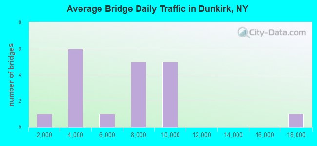
- 121,406Total average daily traffic
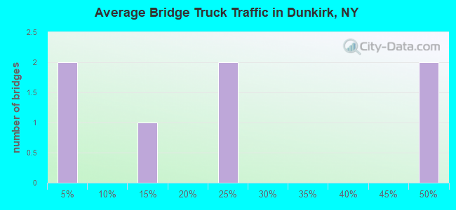
- 11,672Total average daily truck traffic
- National Bridge Inventory (NBI) Registered Bridges for Dunkirk
- No street view available for this location
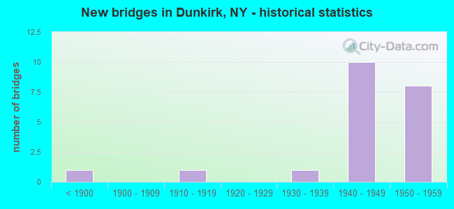
- New bridges - historical statistics
- 1Before 1900
- 11910-1919
- 11930-1939
- 101940-1949
- 81950-1959
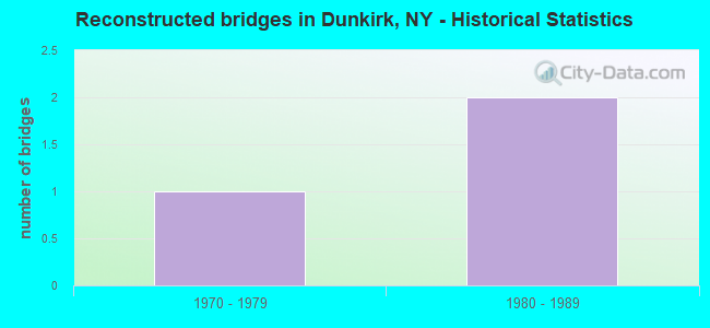
- Reconstructed bridges - Historical Statistics
- 11970-1979
- 21980-1989
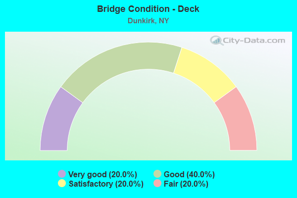
- Bridge Condition - Deck
- 20.0%Very good
- 40.0%Good
- 20.0%Satisfactory
- 20.0%Fair
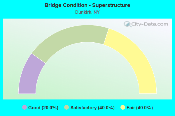
- Bridge Condition - Superstructure
- 20.0%Good
- 40.0%Satisfactory
- 40.0%Fair
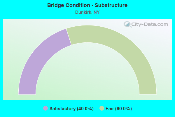
- Bridge Condition - Substructure
- 40.0%Satisfactory
- 60.0%Fair
Find on map >> Show street view
Structure Number: 100124, Location: 6.1 MI NE JCT RTS 5 + 380 (Lat: 42.475439, Lng: -79.365303), Route carried "on" structure: State highway 5, Year Built: 1930, Year Reconstructed: 1977, Status: Open, Structure Length: 3.11m (10.20ft), Average Daily Traffic: 3,274 (year 2017), Truck Traffic: 12%, Average Future Daily Traffic: 3,457 (year 2040), Design Load: HS 20, Features Intersected: CANADAWAY CREEK
Minimum Vertical Clearance: 30+ m (98+ ft), Kilometerpoint: 41.560, Lanes on structure: 2, Base Highway Network: Yes, Owner: State Highway Agency, Approaching Roadway Width: 12.5m (41.0ft), Skew: 1 degrees, Material/Design: Steel, Design/Construction: Girder and Floorbeam System, Number Of Spans In Main Unit: 1, Length of Maximum Span: 30.4m (99.7ft), Curb or Sidewalk Widths: Left: 1.6m (5.2ft), Right: 0.0m, Curb-To-Curb Width: 9.1m (29.9ft), Out-to-Out Width: 10.2m (33.5ft)
Condition: Deck: Good, Superstructure: Fair, Substructure: Fair, Channel: Fair, Operating Rating: 21.7 metric tons, Method Used To Determine Operating Rating: Load and Resistance Factor Rating (LRFR) rating reported by rating factor(RF) method using HL-93 loadings, Inventory Rating: 16.5 metric tons, Method Used To Determine Inventory Rating: Load and Resistance Factor Rating (LRFR) rating reported by rating factor(RF) method using HL-93 loadings, Structural Evaluation: Meets minimum limits, Deck Geometry: Meets minimum limits, Waterway Adequacy: Somewhat better than minimum adequacy, Approach Roadway Alignment: Equal to present minimum criteria, Length Of Structure Improvement: 3.10m (10.17ft), Designated Inspection Frequency: Every 24 months, Critical Feature Inspection Frequency: Every 24 months, Inspection Date: July 2021, Critical Feature Inspection Date: July 2021, Bridge Improvement Cost: $1,560,000, Roadway Improvement Cost: $914,000, Total Project Cost: $2,474,000 ( Estimate for 2021), Deck Structure Type: Concrete Cast-file-Place, Wearing Surface/Protective System: Wearing Surface: Bituminous, Membrane: Other
Find on map >> Show street view
Structure Number: 5511331, Location: 1.5 MI W OF DUNKIRK INT (Lat: 42.459119, Lng: -79.333833), Route carried "on" structure: Interstate 90, Year Built: 1957, Year Reconstructed: 1994, Status: Open, Structure Length: 1.92m (6.30ft), Average Daily Traffic: 9,423 (year 2014), Truck Traffic: 23%, Design Load: HS 20+Mod, Features Intersected: CENTRAL AVE
Minimum Vertical Clearance: 30+ m (98+ ft), Kilometerpoint: 754.943, Lanes on structure: 2, Lanes under structure: 2, Base Highway Network: Yes, Toll: On Interstate toll segment, Owner: State Toll Authority, Approaching Roadway Width: 16.5m (54.1ft), Material/Design: Steel, Design/Construction: Stringer/Multi-beam, Number Of Spans In Main Unit: 1, Length of Maximum Span: 17.7m (58.1ft), Curb-To-Curb Width: 16.3m (53.5ft), Out-to-Out Width: 17.1m (56.1ft)
Condition: Deck: Good, Superstructure: Satisfactory, Substructure: Fair, Operating Rating: 97.1 metric tons, Method Used To Determine Operating Rating: Load Factor (LF), Inventory Rating: 58.1 metric tons, Method Used To Determine Inventory Rating: Load Factor (LF), Structural Evaluation: Somewhat better than minimum adequacy, Deck Geometry: Superior to present desirable criteria, Underclear: Meets minimum limits, Approach Roadway Alignment: Equal to present desirable criteria, Length Of Structure Improvement: 1.92m (6.30ft), Designated Inspection Frequency: Every 24 months, Inspection Date: August 2021, Bridge Improvement Cost: $2,327,000, Roadway Improvement Cost: $1,363,000, Total Project Cost: $3,690,000 ( Estimate for 2021), Deck Structure Type: Concrete Cast-file-Place, Wearing Surface/Protective System: Wearing Surface: Bituminous, Membrane: Other
Find on map >> Show street view
Structure Number: 5511332, Location: 1.5 MI W OF DUNKIRK INT (Lat: 42.458786, Lng: -79.333850), Route carried "on" structure: Interstate 90, Year Built: 1957, Status: Open, Structure Length: 1.92m (6.30ft), Average Daily Traffic: 6,826 (year 2020), Truck Traffic: 49%, Average Future Daily Traffic: 7,650 (year 2040), Design Load: HS 20+Mod, Features Intersected: CENTRAL AVE
Minimum Vertical Clearance: 30+ m (98+ ft), Kilometerpoint: 43.202, Lanes on structure: 2, Lanes under structure: 3, Base Highway Network: Yes, Toll: On Interstate toll segment, Owner: State Toll Authority, Approaching Roadway Width: 12.2m (40.0ft), Material/Design: Steel, Design/Construction: Stringer/Multi-beam, Number Of Spans In Main Unit: 1, Length of Maximum Span: 17.7m (58.1ft), Curb-To-Curb Width: 14.9m (48.9ft), Out-to-Out Width: 17.1m (56.1ft)
Condition: Deck: Satisfactory, Superstructure: Satisfactory, Substructure: Fair, Operating Rating: 86.2 metric tons, Method Used To Determine Operating Rating: Load Factor (LF), Inventory Rating: 51.7 metric tons, Method Used To Determine Inventory Rating: Load Factor (LF), Structural Evaluation: Somewhat better than minimum adequacy, Deck Geometry: Superior to present desirable criteria, Underclear: Meets minimum limits, Approach Roadway Alignment: Equal to present desirable criteria, Length Of Structure Improvement: 1.92m (6.30ft), Designated Inspection Frequency: Every 24 months, Inspection Date: August 2021, Bridge Improvement Cost: $2,327,000, Roadway Improvement Cost: $1,363,000, Total Project Cost: $3,690,000 ( Estimate for 2021), Deck Structure Type: Concrete Cast-file-Place, Wearing Surface/Protective System: Wearing Surface: Bituminous, Membrane: Other
Find on map >> Show street view
Structure Number: 5511341, Location: 1.0 MI W OF DUNKIRK INT (Lat: 42.460144, Lng: -79.324483), Route carried "on" structure: Interstate 90, Year Built: 1955, Year Reconstructed: 1993, Status: Open, Structure Length: 6.61m (21.69ft), Average Daily Traffic: 9,423 (year 2014), Truck Traffic: 23%, Design Load: HS 20+Mod, Features Intersected: MAIN ST EXTENSION, CSX
Minimum Vertical Clearance: 30+ m (98+ ft), Kilometerpoint: 754.154, Lanes on structure: 2, Lanes under structure: 2, Base Highway Network: Yes, Toll: On Interstate toll segment, Owner: State Toll Authority, Approaching Roadway Width: 11.3m (37.1ft), Skew: 1 degrees, Material/Design: Steel continuous, Design/Construction: Stringer/Multi-beam, Number Of Spans In Main Unit: 4, Length of Maximum Span: 19.5m (64.0ft), Curb-To-Curb Width: 16.5m (54.1ft), Out-to-Out Width: 17.1m (56.1ft)
Condition: Deck: Very good, Superstructure: Good, Substructure: Satisfactory, Operating Rating: 81.6 metric tons, Method Used To Determine Operating Rating: Load Factor (LF), Inventory Rating: 49.0 metric tons, Method Used To Determine Inventory Rating: Load Factor (LF), Structural Evaluation: Equal to present minimum criteria, Deck Geometry: Superior to present desirable criteria, Underclear: Somewhat better than minimum adequacy, Approach Roadway Alignment: Equal to present desirable criteria, Length Of Structure Improvement: 6.61m (21.69ft), Designated Inspection Frequency: Every 24 months, Inspection Date: July 2020, Bridge Improvement Cost: $4,117,000, Roadway Improvement Cost: $2,411,000, Total Project Cost: $6,528,000 ( Estimate for 2021), Deck Structure Type: Concrete Cast-file-Place, Wearing Surface/Protective System: Wearing Surface: Bituminous, Membrane: Other, Deck Protection: Epoxy Coated Reinforcing
Find on map >> Show street view
Structure Number: 5511342, Location: 1.0 MI W OF DUNKIRK INT (Lat: 42.459661, Lng: -79.324478), Route carried "on" structure: Interstate 90, Year Built: 1955, Status: Open, Structure Length: 6.61m (21.69ft), Average Daily Traffic: 6,826 (year 2020), Truck Traffic: 49%, Average Future Daily Traffic: 7,650 (year 2040), Design Load: HS 20+Mod, Features Intersected: MAIN ST EXTENSION, CSX
Minimum Vertical Clearance: 30+ m (98+ ft), Kilometerpoint: 43.958, Lanes on structure: 2, Lanes under structure: 2, Base Highway Network: Yes, Toll: On Interstate toll segment, Owner: State Toll Authority, Approaching Roadway Width: 12.2m (40.0ft), Skew: 1 degrees, Material/Design: Steel, Design/Construction: Stringer/Multi-beam, Number Of Spans In Main Unit: 4, Length of Maximum Span: 19.5m (64.0ft), Curb-To-Curb Width: 16.0m (52.5ft), Out-to-Out Width: 17.1m (56.1ft)
Condition: Deck: Fair, Superstructure: Fair, Substructure: Satisfactory, Operating Rating: 59.9 metric tons, Method Used To Determine Operating Rating: Load and Resistance Factor Rating (LRFR) rating reported by rating factor(RF) method using HL-93 loadings, Inventory Rating: 46.3 metric tons, Method Used To Determine Inventory Rating: Load and Resistance Factor Rating (LRFR) rating reported by rating factor(RF) method using HL-93 loadings, Structural Evaluation: Somewhat better than minimum adequacy, Deck Geometry: Superior to present desirable criteria, Underclear: Somewhat better than minimum adequacy, Approach Roadway Alignment: Equal to present desirable criteria, Length Of Structure Improvement: 6.61m (21.69ft), Designated Inspection Frequency: Every 24 months, Inspection Date: July 2020, Bridge Improvement Cost: $4,117,000, Roadway Improvement Cost: $2,411,000, Total Project Cost: $6,528,000 ( Estimate for 2021), Deck Structure Type: Concrete Cast-file-Place, Wearing Surface/Protective System: Wearing Surface: Bituminous, Membrane: Other
Find on map >> Show street view
Structure Number: 5511331, Location: 1.5 MI W OF DUNKIRK INT (Lat: 42.459119, Lng: -79.333833), Route carried "under" structure: City street , Year Built: 1957, Structure Length: 0. m, Average Daily Traffic: 3,245 (year 2020), Truck Traffic: 4%, Features Intersected: CENTRAL AVE, Facility Carried by Structure: RTE I90
Minimum Vertical Clearance: 4.42m (14.50ft), Kilometerpoint: 0.032, Lanes on structure: 2, Lanes under structure: 2, Material/Design: Steel, Design/Construction: Stringer/Multi-beam, Length of Maximum Span: 17.7m (58.1ft)
Find on map >> Show street view
Structure Number: 5511332, Location: 1.5 MI W OF DUNKIRK INT (Lat: 42.458786, Lng: -79.333850), Route carried "under" structure: City street , Year Built: 1957, Structure Length: 0. m, Average Daily Traffic: 3,245 (year 2020), Truck Traffic: 4%, Features Intersected: CENTRAL AVE, Facility Carried by Structure: RTE I90
Minimum Vertical Clearance: 4.42m (14.50ft), Kilometerpoint: 0.000, Lanes on structure: 2, Lanes under structure: 3, Material/Design: Steel, Design/Construction: Stringer/Multi-beam, Length of Maximum Span: 17.7m (58.1ft)
Find on map >> Show street view
Structure Number: 5511341, Location: 1.0 MI W OF DUNKIRK INT (Lat: 42.460144, Lng: -79.324483), Route carried "under" structure: City street , Year Built: 1955, Structure Length: 0. m, Features Intersected: MAIN ST EXTENSION, CSX, Facility Carried by Structure: RTE I90
Minimum Vertical Clearance: 7.11m (23.33ft), Kilometerpoint: 0.306, Lanes on structure: 2, Lanes under structure: 2, Material/Design: Steel continuous, Design/Construction: Stringer/Multi-beam, Length of Maximum Span: 19.5m (64.0ft)
Find on map >> Show street view
Structure Number: 5511342, Location: 1.0 MI W OF DUNKIRK INT (Lat: 42.459661, Lng: -79.324478), Route carried "under" structure: City street , Year Built: 1955, Structure Length: 0. m, Features Intersected: MAIN ST EXTENSION, CSX, Facility Carried by Structure: RTE I90
Minimum Vertical Clearance: 6.98m (22.90ft), Kilometerpoint: 0.000, Lanes on structure: 2, Lanes under structure: 2, Material/Design: Steel, Design/Construction: Stringer/Multi-beam, Length of Maximum Span: 19.5m (64.0ft)
Find on map >> Show street view
Structure Number: 7027901, Location: 0.2 MI S JCT RTS 60 + 5 (Lat: 42.485939, Lng: -79.328781), Route carried "under" structure: State highway 60, Year Built: 1940, Structure Length: 0. m, Average Daily Traffic: 8,834 (year 1998), Features Intersected: RTE 60, Facility Carried by Structure: CSX TRANSPRTATION
Minimum Vertical Clearance: 4.41m (14.47ft), Kilometerpoint: 1.368, Lanes under structure: 2, Material/Design: Steel, Design/Construction: Girder and Floorbeam System, Length of Maximum Span: 14.6m (47.9ft)
Find on map >> Show street view
Structure Number: 7027902, Location: 0.2 MI S JCT RTS 60 + 5 (Lat: 42.486047, Lng: -79.328811), Route carried "under" structure: State highway 60, Year Built: 1940, Structure Length: 0. m, Average Daily Traffic: 8,834 (year 1998), Features Intersected: RTE 60, Facility Carried by Structure: CSX TRANSPRTATION
Minimum Vertical Clearance: 4.47m (14.67ft), Kilometerpoint: 1.368, Lanes under structure: 2, Material/Design: Steel, Design/Construction: Girder and Floorbeam System, Length of Maximum Span: 14.6m (47.9ft)
Find on map >> Show street view
Structure Number: 770737, Location: 0.8 MI W OF DUNKIRK (Lat: 42.463978, Lng: -79.367994), Route carried "under" structure: County highway , Year Built: 1896, Structure Length: 0. m, Average Daily Traffic: 267 (year 2021), Features Intersected: WILLOW RD, Facility Carried by Structure: CSX TRANSPORT
Minimum Vertical Clearance: 3.84m (12.60ft), Kilometerpoint: 0.000, Lanes under structure: 2, Material/Design: Aluminum, Iron, Design/Construction: Box Beam or Girders - Multiple, Length of Maximum Span: 8.2m (26.9ft)
Find on map >> Show street view
Structure Number: 770738, Location: 0.8 MI W OF DUNKIRK (Lat: 42.463739, Lng: -79.367614), Route carried "under" structure: County highway , Year Built: 1915, Structure Length: 0. m, Average Daily Traffic: 2,839 (year 2021), Features Intersected: WILLOW RD-C R 98W, Facility Carried by Structure: NORFOLK SOUTHERN
Minimum Vertical Clearance: 3.53m (11.58ft), Kilometerpoint: 0.193, Lanes under structure: 2, Length of Maximum Span: 8.5m (27.9ft)
Find on map >> Show street view
Structure Number: 77075, Location: AT DUNKIRK,BRIGHAM ROAD (Lat: 42.473833, Lng: -79.346100), Route carried "under" structure: County highway , Year Built: 1940, Structure Length: 0. m, Average Daily Traffic: 4,485 (year 2021), Features Intersected: BRIGHAM RD-CR 98B, Facility Carried by Structure: NORFOLK SOUTHN RR
Minimum Vertical Clearance: 4.41m (14.47ft), Kilometerpoint: 2.430, Lanes under structure: 2, Material/Design: Steel, Design/Construction: Stringer/Multi-beam, Length of Maximum Span: 13.4m (44.0ft)
Find on map >> Show street view
Structure Number: 770751, Location: AT DUNKIRK,CENTRAL AVENUE (Lat: 42.473767, Lng: -79.333131), Route carried "under" structure: County highway , Year Built: 1940, Structure Length: 0. m, Average Daily Traffic: 16,474 (year 2021), Features Intersected: CR136-CENTRAL AVE, Facility Carried by Structure: NORFOLK SOUTHERN
Minimum Vertical Clearance: 4.36m (14.30ft), Kilometerpoint: 3.524, Lanes under structure: 2, Material/Design: Steel, Design/Construction: Stringer/Multi-beam, Length of Maximum Span: 13.4m (44.0ft)
Find on map >> Show street view
Structure Number: 770752, Location: AT DUNKIRK,BRIGHAM ROAD (Lat: 42.482700, Lng: -79.345975), Route carried "under" structure: County highway , Year Built: 1941, Structure Length: 0. m, Average Daily Traffic: 6,708 (year 2021), Features Intersected: BRIGHAM RD, Facility Carried by Structure: CSX TRANSPORT
Minimum Vertical Clearance: 3.88m (12.73ft), Kilometerpoint: 0.000, Lanes under structure: 2, Material/Design: Steel, Design/Construction: Stringer/Multi-beam, Length of Maximum Span: 15.5m (50.9ft)
Find on map >> Show street view
Structure Number: 770753, Location: AT DUNKIRK,SWAN STREET (Lat: 42.484547, Lng: -79.338069), Route carried "under" structure: City street , Year Built: 1940, Structure Length: 0. m, Average Daily Traffic: 3,715 (year 2021), Features Intersected: SWAN STREET, Facility Carried by Structure: CSX TRANSPORT
Minimum Vertical Clearance: 3.93m (12.89ft), Kilometerpoint: 1.126, Lanes under structure: 2, Material/Design: Steel, Design/Construction: Stringer/Multi-beam, Length of Maximum Span: 13.4m (44.0ft)
Find on map >> Show street view
Structure Number: 770754, Location: AT DUNKIRK,CENTRAL AVENUE (Lat: 42.485061, Lng: -79.334994), Route carried "under" structure: County highway , Year Built: 1941, Structure Length: 0. m, Average Daily Traffic: 8,568 (year 2021), Features Intersected: CENTRAL AVE, Facility Carried by Structure: CSX TRANSPORT
Minimum Vertical Clearance: 4.34m (14.24ft), Kilometerpoint: 0.000, Lanes under structure: 2, Material/Design: Steel, Design/Construction: Stringer/Multi-beam, Length of Maximum Span: 14.9m (48.9ft)
Find on map >> Show street view
Structure Number: 770755, Location: AT DUNKIRK,WASHINGTON RD (Lat: 42.485319, Lng: -79.333433), Route carried "under" structure: City street , Year Built: 1940, Structure Length: 0. m, Average Daily Traffic: 2,760 (year 2021), Features Intersected: WASHINGTON AVENUE, Facility Carried by Structure: CSX TRANSPORT
Minimum Vertical Clearance: 3.96m (12.99ft), Kilometerpoint: 1.255, Lanes under structure: 2, Material/Design: Steel, Design/Construction: Stringer/Multi-beam, Length of Maximum Span: 13.4m (44.0ft)
Find on map >> Show street view
Structure Number: 7707571, Location: AT DUNKIRK,ROBERTS ROAD (Lat: 42.486994, Lng: -79.321006), Route carried "under" structure: County highway , Year Built: 1940, Structure Length: 0. m, Average Daily Traffic: 7,830 (year 2021), Features Intersected: ROBERTS RD, Facility Carried by Structure: CSX TRANSPORT
Minimum Vertical Clearance: 4.31m (14.14ft), Kilometerpoint: 0.000, Lanes under structure: 2, Material/Design: Steel, Design/Construction: Stringer/Multi-beam, Length of Maximum Span: 17.9m (58.7ft)
Find on map >> Show street view
Structure Number: 7707572, Location: AT DUNKIRK,ROBERTS ROAD (Lat: 42.486922, Lng: -79.320867), Route carried "under" structure: County highway , Year Built: 1940, Structure Length: 0. m, Average Daily Traffic: 7,830 (year 2021), Features Intersected: ROBERTS RD, Facility Carried by Structure: CSX TRANSPORT
Minimum Vertical Clearance: 4.36m (14.30ft), Kilometerpoint: 0.000, Lanes under structure: 2, Material/Design: Steel, Design/Construction: Girder and Floorbeam System, Length of Maximum Span: 18.2m (59.7ft)