Bridge Statistics for Durand, Michigan (MI)
Condition, Traffic, Stress, Structural Evaluation, Project Costs
- National Bridge Inventory (NBI) Statistics
- 29Number of bridges
- 246ft / 75.2mTotal length
- 576,819Total average daily traffic
- 98,135Total average daily truck traffic
- National Bridge Inventory (NBI) Registered Bridges for Durand
- No street view available for this location
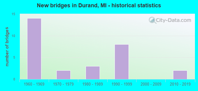
- New bridges - historical statistics
- 141960-1969
- 21970-1979
- 31980-1989
- 81990-1999
- 22010-2019

- Reconstructed bridges - Historical Statistics
- 11990-1999
- 12000-2009


- Bridge Condition - Deck
- 4.8%Very good
- 52.4%Good
- 38.1%Satisfactory
- 4.8%Fair

- Bridge Condition - Superstructure
- 14.3%Very good
- 52.4%Good
- 28.6%Satisfactory
- 4.8%Fair

- Bridge Condition - Substructure
- 19.0%Very good
- 61.9%Good
- 14.3%Satisfactory
- 4.8%Fair

- Bridge Condition - Channel
- 5.6%Very good
- 44.4%Good
- 33.3%Satisfactory
- 11.1%Fair
- 5.6%Poor

- Bridge Condition - Culverts
- 33.3%Good
- 33.3%Satisfactory
- 33.3%Fair
Find on map >> Show street view
Structure Number: 1829, Location: 1.6 MI E OF US-127 BR (Lat: 43.001353, Lng: -84.519058), Route carried "on" structure: US 127, Year Built: 1993, Status: Open, Structure Length: 3.93m (12.89ft), Average Daily Traffic: 10,100 (year 2020), Truck Traffic: 8%, Average Future Daily Traffic: 11,163 (year 2040), Design Load: HS 25 or greater, Features Intersected: M-21
Minimum Vertical Clearance: 30.48m (100.00ft), Kilometerpoint: 8.078, Lanes on structure: 2, Lanes under structure: 5, Base Highway Network: Yes (Inventory Route: 319, Subroute: 1), Owner: State Highway Agency, Approaching Roadway Width: 13.4m (44.0ft), Material/Design: Prestressed concrete, Design/Construction: Stringer/Multi-beam, Number Of Spans In Main Unit: 1, Length of Maximum Span: 38.1m (125.0ft), Curb-To-Curb Width: 13.4m (44.0ft), Out-to-Out Width: 14.4m (47.2ft)
Condition: Deck: Good, Superstructure: Satisfactory, Substructure: Good, Operating Rating: 93.0 metric tons, Method Used To Determine Operating Rating: Load Factor (LF) rating reported by rating factor (RF) method using MS18 loading, Inventory Rating: 34.7 metric tons, Method Used To Determine Inventory Rating: Load Factor (LF) rating reported by rating factor (RF) method using MS18 loading, Structural Evaluation: Equal to present minimum criteria, Deck Geometry: Superior to present desirable criteria, Underclear: Better than present minimum criteria, Approach Roadway Alignment: Equal to present desirable criteria, Designated Inspection Frequency: Every 24 months, Inspection Date: May 2020, Deck Structure Type: Concrete Cast-file-Place, Wearing Surface/Protective System: Wearing Surface: Epoxy Overlay, Deck Protection: Epoxy Coated Reinforcing
Find on map >> Show street view
Structure Number: 2355, Location: 8 MILES E OF OLIVET (Lat: 42.454886, Lng: -84.777264), Route carried "on" structure: County highway 2361, Year Built: 1966, Status: Open, Structure Length: 0.64m (2.10ft), Average Daily Traffic: 953 (year 2009), Average Future Daily Traffic: 840 (year 2013), Design Load: HS 20+Mod, Features Intersected: BATTLE CREEK RIVER, Facility Carried by Structure: NARROW LAKE ROAD
Minimum Vertical Clearance: 30.48m (100.00ft), Kilometerpoint: 3.829, Lanes on structure: 2, Owner: County Highway Agency, Approaching Roadway Width: 11.0m (36.1ft), Material/Design: Steel, Design/Construction: Culvert, Number Of Spans In Main Unit: 1, Length of Maximum Span: 6.4m (21.0ft), Curb-To-Curb Width: 13.0m (42.7ft), Out-to-Out Width: 13.4m (44.0ft)
Condition: Channel: Good, Culverts: Satisfactory, Operating Rating: 72.3 metric tons, Method Used To Determine Operating Rating: Load Factor (LF) rating reported by rating factor (RF) method using MS18 loading, Inventory Rating: 43.4 metric tons, Method Used To Determine Inventory Rating: Load Factor (LF) rating reported by rating factor (RF) method using MS18 loading, Structural Evaluation: Equal to present minimum criteria, Deck Geometry: Superior to present desirable criteria, Waterway Adequacy: Equal to present desirable criteria, Approach Roadway Alignment: Equal to present desirable criteria, Designated Inspection Frequency: Every 24 months, Inspection Date: April 2021
Find on map >> Show street view
Structure Number: 3195, Location: SEC 18 ELBA TWP (Lat: 43.164931, Lng: -84.477406), Route carried "on" structure: County highway , Year Built: 1992, Status: Open, Structure Length: 2.04m (6.69ft), Average Daily Traffic: 112 (year 2004), Average Future Daily Traffic: 139 (year 2024), Design Load: HS 20, Features Intersected: WOLF & BEAR CREEK DRAIN, Facility Carried by Structure: ARNOLD ROAD
Minimum Vertical Clearance: 30.48m (100.00ft), Kilometerpoint: 0.406, Lanes on structure: 2, Owner: County Highway Agency, Approaching Roadway Width: 8.5m (27.9ft), Skew: 1 degrees, Material/Design: Prestressed concrete, Design/Construction: Box Beam or Girders - Multiple, Number Of Spans In Main Unit: 1, Length of Maximum Span: 20.4m (66.9ft), Curb-To-Curb Width: 8.8m (28.9ft), Out-to-Out Width: 9.4m (30.8ft)
Condition: Deck: Good, Superstructure: Satisfactory, Substructure: Good, Channel: Very good, Operating Rating: 57.0 metric tons, Method Used To Determine Operating Rating: Load Factor (LF), Inventory Rating: 34.2 metric tons, Method Used To Determine Inventory Rating: Load Factor (LF), Structural Evaluation: Equal to present minimum criteria, Deck Geometry: Equal to present minimum criteria, Waterway Adequacy: Equal to present desirable criteria, Approach Roadway Alignment: Equal to present desirable criteria, Designated Inspection Frequency: Every 24 months, Inspection Date: July 2020, Deck Structure Type: Concrete Precast Panels, Wearing Surface/Protective System: Wearing Surface: Bituminous, Membrane: Preformed Fabric
Find on map >> Show street view
Structure Number: 5134, Location: 300 FT W OF WHITNEYVILLE (Lat: 42.870472, Lng: -85.460144), Route carried "on" structure: County highway , Year Built: 1971, Status: Open, Structure Length: 0.79m (2.59ft), Average Daily Traffic: 142 (year 2004), Average Future Daily Traffic: 240 (year 2024), Design Load: HS 20+Mod, Features Intersected: UNNAMED, Facility Carried by Structure: 52ND STREET
Minimum Vertical Clearance: 30.48m (100.00ft), Kilometerpoint: 0.713, Lanes on structure: 2, Owner: County Highway Agency, Approaching Roadway Width: 4.9m (16.1ft), Material/Design: Steel, Design/Construction: Culvert, Number Of Spans In Main Unit: 2, Length of Maximum Span: 3.9m (12.8ft)
Condition: Channel: Fair, Culverts: Fair, Operating Rating: 49.2 metric tons, Method Used To Determine Operating Rating: Load Factor (LF) rating reported by rating factor (RF) method using MS18 loading, Inventory Rating: 42.8 metric tons, Method Used To Determine Inventory Rating: Load Factor (LF) rating reported by rating factor (RF) method using MS18 loading, Structural Evaluation: Somewhat better than minimum adequacy, Waterway Adequacy: Equal to present desirable criteria, Approach Roadway Alignment: Equal to present minimum criteria, Designated Inspection Frequency: Every 24 months, Inspection Date: November 2021
Find on map >> Show street view
Structure Number: 9736, Location: 0.3 MI NE OF M-71 (Lat: 42.928894, Lng: -83.994878), Route carried "on" structure: Interstate 69, Year Built: 1961, Status: Open, Structure Length: 1.83m (6.00ft), Average Daily Traffic: 192,000 (year 2011), Truck Traffic: 17%, Average Future Daily Traffic: 212,000 (year 2031), Design Load: HS 25 or greater, Features Intersected: HOLLY DRAIN
Minimum Vertical Clearance: 30.48m (100.00ft), Kilometerpoint: 34.058, Lanes on structure: 2, Base Highway Network: Yes (Inventory Route: 55, Subroute: 8), Owner: State Highway Agency, Approaching Roadway Width: 12.8m (42.0ft), Skew: 13 degrees, Material/Design: Steel, Design/Construction: Stringer/Multi-beam, Number Of Spans In Main Unit: 1, Length of Maximum Span: 17.3m (56.8ft), Curb-To-Curb Width: 13.0m (42.7ft), Out-to-Out Width: 14.3m (46.9ft)
Condition: Deck: Satisfactory, Superstructure: Satisfactory, Substructure: Satisfactory, Channel: Satisfactory, Operating Rating: 83.3 metric tons, Method Used To Determine Operating Rating: Load Factor (LF) rating reported by rating factor (RF) method using MS18 loading, Inventory Rating: 49.9 metric tons, Method Used To Determine Inventory Rating: Load Factor (LF) rating reported by rating factor (RF) method using MS18 loading, Structural Evaluation: Equal to present minimum criteria, Deck Geometry: Superior to present desirable criteria, Waterway Adequacy: Equal to present desirable criteria, Approach Roadway Alignment: Equal to present desirable criteria, Designated Inspection Frequency: Every 24 months, Inspection Date: August 2021, Deck Structure Type: Concrete Cast-file-Place, Wearing Surface/Protective System: Wearing Surface: Epoxy Overlay
Find on map >> Show street view
Structure Number: 9737, Location: 0.3 MI NE OF M-71 (Lat: 42.929000, Lng: -83.995297), Route carried "on" structure: Interstate 69, Year Built: 1961, Status: Open, Structure Length: 1.86m (6.10ft), Average Daily Traffic: 192,000 (year 2011), Truck Traffic: 17%, Average Future Daily Traffic: 212,000 (year 2031), Design Load: HS 25 or greater, Features Intersected: HOLLY DRAIN
Minimum Vertical Clearance: 30.48m (100.00ft), Kilometerpoint: 34.016, Lanes on structure: 2, Base Highway Network: Yes (Inventory Route: 55, Subroute: 9), Owner: State Highway Agency, Approaching Roadway Width: 12.8m (42.0ft), Skew: 13 degrees, Material/Design: Steel, Design/Construction: Stringer/Multi-beam, Number Of Spans In Main Unit: 1, Length of Maximum Span: 17.6m (57.7ft), Curb-To-Curb Width: 13.0m (42.7ft), Out-to-Out Width: 14.3m (46.9ft)
Condition: Deck: Satisfactory, Superstructure: Satisfactory, Substructure: Satisfactory, Channel: Satisfactory, Operating Rating: 81.0 metric tons, Method Used To Determine Operating Rating: Load Factor (LF) rating reported by rating factor (RF) method using MS18 loading, Inventory Rating: 48.3 metric tons, Method Used To Determine Inventory Rating: Load Factor (LF) rating reported by rating factor (RF) method using MS18 loading, Structural Evaluation: Equal to present minimum criteria, Deck Geometry: Superior to present desirable criteria, Waterway Adequacy: Equal to present desirable criteria, Approach Roadway Alignment: Equal to present desirable criteria, Designated Inspection Frequency: Every 24 months, Inspection Date: August 2021, Deck Structure Type: Concrete Cast-file-Place, Wearing Surface/Protective System: Wearing Surface: Epoxy Overlay
Find on map >> Show street view
Structure Number: 9738, Location: 2.7 MI SW OF GENESEE COL (Lat: 42.955989, Lng: -83.969208), Route carried "on" structure: Interstate 69, Year Built: 1961, Status: Open, Structure Length: 1.95m (6.40ft), Average Daily Traffic: 14,378 (year 2007), Truck Traffic: 20%, Average Future Daily Traffic: 15,340 (year 2018), Design Load: HS 25 or greater, Features Intersected: WEBB DRAIN
Minimum Vertical Clearance: 30.48m (100.00ft), Kilometerpoint: 37.732, Lanes on structure: 2, Base Highway Network: Yes (Inventory Route: 55, Subroute: 8), Owner: State Highway Agency, Approaching Roadway Width: 12.8m (42.0ft), Skew: 13 degrees, Material/Design: Steel, Design/Construction: Stringer/Multi-beam, Number Of Spans In Main Unit: 1, Length of Maximum Span: 19.5m (64.0ft), Curb-To-Curb Width: 12.8m (42.0ft), Out-to-Out Width: 14.3m (46.9ft)
Condition: Deck: Good, Superstructure: Good, Substructure: Good, Channel: Satisfactory, Operating Rating: 57.0 metric tons, Method Used To Determine Operating Rating: Load Factor (LF) rating reported by rating factor (RF) method using MS18 loading, Inventory Rating: 34.0 metric tons, Method Used To Determine Inventory Rating: Load Factor (LF) rating reported by rating factor (RF) method using MS18 loading, Structural Evaluation: Better than present minimum criteria, Deck Geometry: Equal to present desirable criteria, Waterway Adequacy: Equal to present desirable criteria, Approach Roadway Alignment: Equal to present desirable criteria, Designated Inspection Frequency: Every 24 months, Inspection Date: August 2021, Deck Structure Type: Concrete Cast-file-Place, Wearing Surface/Protective System: Wearing Surface: Epoxy Overlay
Find on map >> Show street view
Structure Number: 9739, Location: 2.7 MI SW OF GENESEE COL (Lat: 42.955967, Lng: -83.969675), Route carried "on" structure: Interstate 69, Year Built: 1961, Status: Open, Structure Length: 1.95m (6.40ft), Average Daily Traffic: 14,378 (year 2007), Truck Traffic: 20%, Average Future Daily Traffic: 15,340 (year 2018), Design Load: HS 25 or greater, Features Intersected: WEBB DRAIN
Minimum Vertical Clearance: 30.48m (100.00ft), Kilometerpoint: 37.679, Lanes on structure: 2, Base Highway Network: Yes (Inventory Route: 55, Subroute: 9), Owner: State Highway Agency, Approaching Roadway Width: 12.8m (42.0ft), Skew: 13 degrees, Material/Design: Steel, Design/Construction: Stringer/Multi-beam, Number Of Spans In Main Unit: 1, Length of Maximum Span: 19.5m (64.0ft), Curb-To-Curb Width: 12.8m (42.0ft), Out-to-Out Width: 14.3m (46.9ft)
Condition: Deck: Satisfactory, Superstructure: Good, Substructure: Good, Channel: Satisfactory, Operating Rating: 59.3 metric tons, Method Used To Determine Operating Rating: Load Factor (LF) rating reported by rating factor (RF) method using MS18 loading, Inventory Rating: 35.6 metric tons, Method Used To Determine Inventory Rating: Load Factor (LF) rating reported by rating factor (RF) method using MS18 loading, Structural Evaluation: Better than present minimum criteria, Deck Geometry: Equal to present desirable criteria, Waterway Adequacy: Equal to present desirable criteria, Approach Roadway Alignment: Equal to present desirable criteria, Designated Inspection Frequency: Every 24 months, Inspection Date: August 2021, Deck Structure Type: Concrete Cast-file-Place, Wearing Surface/Protective System: Wearing Surface: Epoxy Overlay
Find on map >> Show street view
Structure Number: 9742, Location: 0.6 MI SW OF M-71 (Lat: 42.924239, Lng: -84.011483), Route carried "on" structure: Interstate 69, Year Built: 1961, Year Reconstructed: 1998, Status: Open, Structure Length: 9.18m (30.12ft), Average Daily Traffic: 13,840 (year 2007), Truck Traffic: 22%, Average Future Daily Traffic: 19,072 (year 2018), Design Load: HS 20, Features Intersected: CN RR & REED RD
Minimum Vertical Clearance: 30.48m (100.00ft), Kilometerpoint: 32.605, Lanes on structure: 2, Lanes under structure: 2, Base Highway Network: Yes (Inventory Route: 55, Subroute: 8), Owner: State Highway Agency, Approaching Roadway Width: 14.0m (45.9ft), Skew: 13 degrees, Material/Design: Steel, Design/Construction: Stringer/Multi-beam, Number Of Spans In Main Unit: 6, Length of Maximum Span: 15.8m (51.8ft), Curb-To-Curb Width: 14.0m (45.9ft), Out-to-Out Width: 15.0m (49.2ft)
Condition: Deck: Good, Superstructure: Fair, Substructure: Satisfactory, Operating Rating: 80.6 metric tons, Method Used To Determine Operating Rating: Load Factor (LF), Inventory Rating: 48.3 metric tons, Method Used To Determine Inventory Rating: Load Factor (LF), Structural Evaluation: Somewhat better than minimum adequacy, Deck Geometry: Superior to present desirable criteria, Underclear: Equal to present minimum criteria, Approach Roadway Alignment: Equal to present desirable criteria, Designated Inspection Frequency: Every 24 months, Inspection Date: August 2021, Deck Structure Type: Concrete Cast-file-Place, Wearing Surface/Protective System: Wearing Surface: Monolithic Concrete, Deck Protection: Epoxy Coated Reinforcing
Find on map >> Show street view
Structure Number: 9752, Location: @ M-71 (Lat: 42.927011, Lng: -84.000750), Route carried "on" structure: State highway 71, Year Built: 2011, Status: Open, Structure Length: 8.96m (29.40ft), Average Daily Traffic: 8,100 (year 2011), Truck Traffic: 5%, Average Future Daily Traffic: 8,900 (year 2031), Design Load: HL 93, Features Intersected: I-69
Minimum Vertical Clearance: 30.48m (100.00ft), Kilometerpoint: 0.150, Lanes on structure: 2, Lanes under structure: 6, Base Highway Network: Yes (Inventory Route: 55, Subroute: 3), Owner: State Highway Agency, Approaching Roadway Width: 12.8m (42.0ft), Skew: 1 degrees, Material/Design: Steel continuous, Design/Construction: Stringer/Multi-beam, Number Of Spans In Main Unit: 4, Length of Maximum Span: 31.1m (102.0ft), Curb-To-Curb Width: 13.4m (44.0ft), Out-to-Out Width: 14.4m (47.2ft)
Condition: Deck: Good, Superstructure: Good, Substructure: Good, Operating Rating: 61.6 metric tons, Method Used To Determine Operating Rating: Load and Resistance Factor Rating (LRFR) rating reported by rating factor(RF) method using HL-93 loadings, Inventory Rating: 47.6 metric tons, Method Used To Determine Inventory Rating: Load and Resistance Factor Rating (LRFR) rating reported by rating factor(RF) method using HL-93 loadings, Structural Evaluation: Better than present minimum criteria, Deck Geometry: Equal to present minimum criteria, Underclear: Equal to present minimum criteria, Approach Roadway Alignment: Equal to present minimum criteria, Designated Inspection Frequency: Every 24 months, Inspection Date: August 2021, Deck Structure Type: Concrete Cast-file-Place, Wearing Surface/Protective System: Wearing Surface: Monolithic Concrete, Deck Protection: Epoxy Coated Reinforcing
Find on map >> Show street view
Structure Number: 9753, Location: 0.8 MI NE OF M-71 (Lat: 42.934553, Lng: -83.988567), Route carried "on" structure: County highway 7687, Year Built: 1961, Status: Open, Structure Length: 10.89m (35.73ft), Average Daily Traffic: 2,882 (year 2011), Truck Traffic: 4%, Average Future Daily Traffic: 3,184 (year 2031), Design Load: H 15, Features Intersected: I-69, Facility Carried by Structure: DURAND RD
Minimum Vertical Clearance: 30.48m (100.00ft), Kilometerpoint: 11.237, Lanes on structure: 2, Lanes under structure: 5, Owner: State Highway Agency, Approaching Roadway Width: 11.5m (37.7ft), Skew: 5 degrees, Material/Design: Steel, Design/Construction: Stringer/Multi-beam, Number Of Spans In Main Unit: 5, Length of Maximum Span: 30.4m (99.7ft), Curb-To-Curb Width: 9.1m (29.9ft), Out-to-Out Width: 10.2m (33.5ft)
Condition: Deck: Satisfactory, Superstructure: Good, Substructure: Good, Operating Rating: 54.4 metric tons, Method Used To Determine Operating Rating: Load Factor (LF) rating reported by rating factor (RF) method using MS18 loading, Inventory Rating: 32.7 metric tons, Method Used To Determine Inventory Rating: Load Factor (LF) rating reported by rating factor (RF) method using MS18 loading, Structural Evaluation: Better than present minimum criteria, Deck Geometry: Meets minimum limits, Underclear: Meets minimum limits, Approach Roadway Alignment: Equal to present desirable criteria, Designated Inspection Frequency: Every 24 months, Inspection Date: August 2021, Deck Structure Type: Concrete Cast-file-Place, Wearing Surface/Protective System: Wearing Surface: Latex Concrete, Deck Protection: Epoxy Coated Reinforcing
Find on map >> Show street view
Structure Number: 9754, Location: 2.7 MI SW OF GENESEE COL (Lat: 42.950953, Lng: -83.973733), Route carried "on" structure: County highway , Year Built: 1961, Status: Open, Structure Length: 7.67m (25.16ft), Average Daily Traffic: 250 (year 1988), Average Future Daily Traffic: 220 (year 1977), Design Load: H 20, Features Intersected: I-69, Facility Carried by Structure: GOODALL RD
Minimum Vertical Clearance: 30.48m (100.00ft), Kilometerpoint: 5.889, Lanes on structure: 2, Lanes under structure: 4, Owner: State Highway Agency, Approaching Roadway Width: 7.9m (25.9ft), Skew: 3 degrees, Material/Design: Steel, Design/Construction: Stringer/Multi-beam, Number Of Spans In Main Unit: 4, Length of Maximum Span: 26.2m (86.0ft), Curb-To-Curb Width: 9.1m (29.9ft), Out-to-Out Width: 10.2m (33.5ft)
Condition: Deck: Satisfactory, Superstructure: Satisfactory, Substructure: Good, Operating Rating: 73.2 metric tons, Method Used To Determine Operating Rating: Load Factor (LF) rating reported by rating factor (RF) method using MS18 loading, Inventory Rating: 43.7 metric tons, Method Used To Determine Inventory Rating: Load Factor (LF) rating reported by rating factor (RF) method using MS18 loading, Structural Evaluation: Equal to present minimum criteria, Deck Geometry: Equal to present minimum criteria, Underclear: Meets minimum limits, Approach Roadway Alignment: Equal to present desirable criteria, Designated Inspection Frequency: Every 24 months, Inspection Date: August 2021, Deck Structure Type: Concrete Cast-file-Place, Wearing Surface/Protective System: Wearing Surface: Epoxy Overlay
Find on map >> Show street view
Structure Number: 9769, Location: 0.3 MI NW OF I-69 (Lat: 42.928978, Lng: -84.002586), Route carried "on" structure: State highway 71, Year Built: 1961, Year Reconstructed: 2011, Status: Open, Structure Length: 1.81m (5.94ft), Average Daily Traffic: 8,100 (year 2011), Truck Traffic: 5%, Average Future Daily Traffic: 8,900 (year 2031), Design Load: HS 20+Mod, Features Intersected: HOLLY DRAIN
Minimum Vertical Clearance: 30.48m (100.00ft), Kilometerpoint: 0.415, Lanes on structure: 2, Base Highway Network: Yes (Inventory Route: 55, Subroute: 3), Owner: State Highway Agency, Approaching Roadway Width: 13.4m (44.0ft), Skew: 3 degrees, Material/Design: Steel, Design/Construction: Stringer/Multi-beam, Number Of Spans In Main Unit: 1, Length of Maximum Span: 17.2m (56.4ft), Curb-To-Curb Width: 13.4m (44.0ft), Out-to-Out Width: 14.4m (47.2ft)
Condition: Deck: Good, Superstructure: Very good, Substructure: Good, Channel: Satisfactory, Operating Rating: 80.7 metric tons, Method Used To Determine Operating Rating: Load Factor (LF) rating reported by rating factor (RF) method using MS18 loading, Inventory Rating: 48.3 metric tons, Method Used To Determine Inventory Rating: Load Factor (LF) rating reported by rating factor (RF) method using MS18 loading, Structural Evaluation: Better than present minimum criteria, Deck Geometry: Equal to present minimum criteria, Waterway Adequacy: Equal to present desirable criteria, Approach Roadway Alignment: Equal to present minimum criteria, Designated Inspection Frequency: Every 24 months, Inspection Date: August 2021, Deck Structure Type: Concrete Cast-file-Place, Wearing Surface/Protective System: Wearing Surface: Monolithic Concrete
Find on map >> Show street view
Structure Number: 9784, Location: 1 MILE NW OF DURAND (Lat: 42.923814, Lng: -84.010672), Route carried "on" structure: County highway 7628, Year Built: 1992, Status: Open, Structure Length: 4.75m (15.58ft), Average Daily Traffic: 3,723 (year 2011), Truck Traffic: 20%, Average Future Daily Traffic: 5,532 (year 2031), Design Load: HS 20, Features Intersected: GTW RR & GARRISON RD, Facility Carried by Structure: LANSING ROAD
Minimum Vertical Clearance: 30.48m (100.00ft), Kilometerpoint: 20.087, Lanes on structure: 2, Lanes under structure: 2, Owner: County Highway Agency, Approaching Roadway Width: 12.0m (39.4ft), Skew: 3 degrees, Material/Design: Prestressed concrete, Design/Construction: Stringer/Multi-beam, Number Of Spans In Main Unit: 2, Length of Maximum Span: 22.5m (73.8ft), Curb-To-Curb Width: 12.0m (39.4ft), Out-to-Out Width: 13.2m (43.3ft)
Condition: Deck: Satisfactory, Superstructure: Good, Substructure: Good, Operating Rating: 65.4 metric tons, Method Used To Determine Operating Rating: Load Factor (LF) rating reported by rating factor (RF) method using MS18 loading, Inventory Rating: 39.2 metric tons, Method Used To Determine Inventory Rating: Load Factor (LF) rating reported by rating factor (RF) method using MS18 loading, Structural Evaluation: Better than present minimum criteria, Deck Geometry: Somewhat better than minimum adequacy, Underclear: High priority of corrective action, Approach Roadway Alignment: Equal to present desirable criteria, Designated Inspection Frequency: Every 24 months, Inspection Date: March 2022, Deck Structure Type: Concrete Cast-file-Place, Wearing Surface/Protective System: Wearing Surface: Integral Concrete, Deck Protection: Epoxy Coated Reinforcing
Find on map >> Show street view
Structure Number: 9785, Location: 0.5 MI NE OF DURAND (Lat: 42.925469, Lng: -83.975775), Route carried "on" structure: County highway 7628, Year Built: 1988, Status: Posted for load, Structure Length: 1.61m (5.28ft), Average Daily Traffic: 6,858 (year 2011), Truck Traffic: 20%, Average Future Daily Traffic: 10,190 (year 2031), Design Load: HS 20, Features Intersected: HOLLY DRAIN, Facility Carried by Structure: LANSING ROAD
Minimum Vertical Clearance: 30.48m (100.00ft), Kilometerpoint: 22.974, Lanes on structure: 2, Owner: County Highway Agency, Approaching Roadway Width: 11.9m (39.0ft), Skew: 3 degrees, Material/Design: Prestressed concrete, Design/Construction: Box Beam or Girders - Multiple, Number Of Spans In Main Unit: 1, Length of Maximum Span: 14.6m (47.9ft), Curb-To-Curb Width: 12.3m (40.4ft), Out-to-Out Width: 13.1m (43.0ft)
Condition: Deck: Fair, Superstructure: Good, Substructure: Fair, Channel: Good, Operating Rating: 49.6 metric tons, Method Used To Determine Operating Rating: Load Factor (LF) rating reported by rating factor (RF) method using MS18 loading, Inventory Rating: 29.8 metric tons, Method Used To Determine Inventory Rating: Load Factor (LF) rating reported by rating factor (RF) method using MS18 loading, Structural Evaluation: Somewhat better than minimum adequacy, Deck Geometry: Somewhat better than minimum adequacy, Waterway Adequacy: Equal to present desirable criteria, Approach Roadway Alignment: Equal to present desirable criteria, Bridge Posting: Required (Relationship of Operating Rating to Maximum Legal Load: 0.1 - 9.9% below), Designated Inspection Frequency: Every 24 months, Inspection Date: April 2020, Deck Structure Type: Concrete Cast-file-Place, Wearing Surface/Protective System: Wearing Surface: Monolithic Concrete, Deck Protection: Epoxy Coated Reinforcing
Find on map >> Show street view
Structure Number: 9818, Location: 1 MILE NORTH OF DURAND (Lat: 42.927347, Lng: -83.988297), Route carried "on" structure: County highway 7687, Year Built: 1967, Status: Open, Structure Length: 1.70m (5.58ft), Average Daily Traffic: 7,643 (year 2011), Truck Traffic: 15%, Average Future Daily Traffic: 11,313 (year 2031), Design Load: HS 20, Features Intersected: HOLLY DRAIN, Facility Carried by Structure: DURAND ROAD
Minimum Vertical Clearance: 30.48m (100.00ft), Kilometerpoint: 10.437, Lanes on structure: 2, Owner: County Highway Agency, Approaching Roadway Width: 9.1m (29.9ft), Material/Design: Steel, Design/Construction: Stringer/Multi-beam, Number Of Spans In Main Unit: 1, Length of Maximum Span: 15.8m (51.8ft), Curb or Sidewalk Widths: Left: 0.4m (1.3ft), Right: 0.4m (1.3ft), Curb-To-Curb Width: 9.1m (29.9ft), Out-to-Out Width: 10.0m (32.8ft)
Condition: Deck: Satisfactory, Superstructure: Satisfactory, Substructure: Good, Channel: Satisfactory, Operating Rating: 97.2 metric tons, Method Used To Determine Operating Rating: Load Factor (LF) rating reported by rating factor (RF) method using MS18 loading, Inventory Rating: 68.0 metric tons, Method Used To Determine Inventory Rating: Load Factor (LF) rating reported by rating factor (RF) method using MS18 loading, Structural Evaluation: Equal to present minimum criteria, Deck Geometry: High priority of corrective action, Waterway Adequacy: Equal to present desirable criteria, Approach Roadway Alignment: Equal to present desirable criteria, Designated Inspection Frequency: Every 24 months, Inspection Date: April 2020, Deck Structure Type: Concrete Cast-file-Place, Wearing Surface/Protective System: Wearing Surface: Monolithic Concrete
Find on map >> Show street view
Structure Number: 9819, Location: 2.5 MILES NORTH OF DURAND (Lat: 42.958561, Lng: -83.987111), Route carried "on" structure: County highway 7687, Year Built: 1965, Status: Open, Structure Length: 1.98m (6.50ft), Average Daily Traffic: 3,203 (year 2011), Truck Traffic: 10%, Average Future Daily Traffic: 4,760 (year 2031), Design Load: HS 20, Features Intersected: WEBB CREEK, Facility Carried by Structure: DURAND ROAD
Minimum Vertical Clearance: 30.48m (100.00ft), Kilometerpoint: 13.928, Lanes on structure: 2, Owner: County Highway Agency, Approaching Roadway Width: 9.1m (29.9ft), Skew: 2 degrees, Material/Design: Steel, Design/Construction: Stringer/Multi-beam, Number Of Spans In Main Unit: 1, Length of Maximum Span: 19.2m (63.0ft), Curb or Sidewalk Widths: Left: 0.4m (1.3ft), Right: 0.4m (1.3ft), Curb-To-Curb Width: 7.9m (25.9ft), Out-to-Out Width: 9.3m (30.5ft)
Condition: Deck: Good, Superstructure: Good, Substructure: Good, Channel: Poor, Operating Rating: 76.8 metric tons, Method Used To Determine Operating Rating: Load Factor (LF) rating reported by rating factor (RF) method using MS18 loading, Inventory Rating: 46.0 metric tons, Method Used To Determine Inventory Rating: Load Factor (LF) rating reported by rating factor (RF) method using MS18 loading, Structural Evaluation: Better than present minimum criteria, Deck Geometry: High priority of corrective action, Waterway Adequacy: Equal to present desirable criteria, Approach Roadway Alignment: Equal to present desirable criteria, Designated Inspection Frequency: Every 24 months, Inspection Date: April 2020, Deck Structure Type: Concrete Cast-file-Place, Wearing Surface/Protective System: Wearing Surface: Bituminous
Find on map >> Show street view
Structure Number: 9871, Location: 0.5 MI N 1 MI E OF DURAND (Lat: 42.918397, Lng: -83.965983), Route carried "on" structure: County highway , Year Built: 1986, Status: Open, Structure Length: 1.83m (6.00ft), Average Daily Traffic: 363 (year 2016), Truck Traffic: 5%, Average Future Daily Traffic: 539 (year 2036), Design Load: HS 20+Mod, Features Intersected: THREE MILE CREEK, Facility Carried by Structure: MONROE RD
Minimum Vertical Clearance: 30.48m (100.00ft), Kilometerpoint: 1.885, Lanes on structure: 2, Owner: County Highway Agency, Approaching Roadway Width: 11.9m (39.0ft), Skew: 3 degrees, Material/Design: Prestressed concrete, Design/Construction: Box Beam or Girders - Multiple, Number Of Spans In Main Unit: 1, Length of Maximum Span: 16.7m (54.8ft), Curb-To-Curb Width: 10.8m (35.4ft), Out-to-Out Width: 11.4m (37.4ft)
Condition: Deck: Good, Superstructure: Good, Substructure: Very good, Channel: Good, Operating Rating: 69.7 metric tons, Method Used To Determine Operating Rating: Load Factor (LF) rating reported by rating factor (RF) method using MS18 loading, Inventory Rating: 41.8 metric tons, Method Used To Determine Inventory Rating: Load Factor (LF) rating reported by rating factor (RF) method using MS18 loading, Structural Evaluation: Better than present minimum criteria, Deck Geometry: Better than present minimum criteria, Waterway Adequacy: Equal to present desirable criteria, Approach Roadway Alignment: Equal to present desirable criteria, Designated Inspection Frequency: Every 19 months, Inspection Date: October 2020, Deck Structure Type: Concrete Precast Panels, Wearing Surface/Protective System: Wearing Surface: Bituminous, Membrane: Preformed Fabric
Find on map >> Show street view
Structure Number: 9872, Location: 1.5 MI NE OF DURAND (Lat: 42.918589, Lng: -83.957572), Route carried "on" structure: County highway , Year Built: 1996, Status: Open, Structure Length: 1.22m (4.00ft), Average Daily Traffic: 155 (year 1998), Truck Traffic: 5%, Average Future Daily Traffic: 284 (year 2018), Design Load: HS 20, Features Intersected: MIKAN DRAIN, Facility Carried by Structure: MONROE RD
Minimum Vertical Clearance: 30.48m (100.00ft), Kilometerpoint: 2.572, Lanes on structure: 2, Owner: County Highway Agency, Approaching Roadway Width: 9.1m (29.9ft), Material/Design: Prestressed concrete, Design/Construction: Box Beam or Girders - Multiple, Number Of Spans In Main Unit: 1, Length of Maximum Span: 11.0m (36.1ft), Curb-To-Curb Width: 9.1m (29.9ft), Out-to-Out Width: 9.6m (31.5ft)
Condition: Deck: Good, Superstructure: Very good, Substructure: Very good, Channel: Good, Operating Rating: 97.2 metric tons, Method Used To Determine Operating Rating: Load Factor (LF) rating reported by rating factor (RF) method using MS18 loading, Inventory Rating: 61.9 metric tons, Method Used To Determine Inventory Rating: Load Factor (LF) rating reported by rating factor (RF) method using MS18 loading, Structural Evaluation: Equal to present desirable criteria, Deck Geometry: Equal to present minimum criteria, Waterway Adequacy: Meets minimum limits, Approach Roadway Alignment: Better than present minimum criteria, Designated Inspection Frequency: Every 24 months, Inspection Date: April 2020, Deck Structure Type: Concrete Precast Panels, Wearing Surface/Protective System: Wearing Surface: Monolithic Concrete, Deck Protection: Epoxy Coated Reinforcing
Find on map >> Show street view
Structure Number: 9873, Location: 2 MI S .6 MI W OF LENNON (Lat: 42.940611, Lng: -83.943103), Route carried "on" structure: County highway , Year Built: 1997, Status: Open, Structure Length: 1.89m (6.20ft), Average Daily Traffic: 128 (year 1996), Truck Traffic: 5%, Average Future Daily Traffic: 231 (year 2016), Design Load: HS 20, Features Intersected: WEBB CREEK, Facility Carried by Structure: BENNINGTON RD
Minimum Vertical Clearance: 30.48m (100.00ft), Kilometerpoint: 3.198, Lanes on structure: 2, Owner: County Highway Agency, Approaching Roadway Width: 9.1m (29.9ft), Material/Design: Prestressed concrete, Design/Construction: Box Beam or Girders - Multiple, Number Of Spans In Main Unit: 1, Length of Maximum Span: 17.7m (58.1ft), Curb-To-Curb Width: 9.1m (29.9ft), Out-to-Out Width: 9.6m (31.5ft)
Condition: Deck: Satisfactory, Superstructure: Good, Substructure: Very good, Channel: Fair, Operating Rating: 73.5 metric tons, Method Used To Determine Operating Rating: Load Factor (LF) rating reported by rating factor (RF) method using MS18 loading, Inventory Rating: 44.1 metric tons, Method Used To Determine Inventory Rating: Load Factor (LF) rating reported by rating factor (RF) method using MS18 loading, Structural Evaluation: Better than present minimum criteria, Deck Geometry: Equal to present minimum criteria, Waterway Adequacy: Equal to present minimum criteria, Approach Roadway Alignment: Equal to present desirable criteria, Designated Inspection Frequency: Every 24 months, Inspection Date: April 2020, Deck Structure Type: Concrete Precast Panels, Wearing Surface/Protective System: Wearing Surface: Monolithic Concrete, Deck Protection: Epoxy Coated Reinforcing
Find on map >> Show street view
Structure Number: 9877, Location: 1.2 MI SE OF VERNON (Lat: 42.929169, Lng: -84.008150), Route carried "on" structure: County highway , Year Built: 1994, Status: Open, Structure Length: 2.13m (6.99ft), Average Daily Traffic: 179 (year 2020), Truck Traffic: 5%, Average Future Daily Traffic: 218 (year 2040), Design Load: HS 20, Features Intersected: HOLLY DRAIN, Facility Carried by Structure: REED RD
Minimum Vertical Clearance: 30.48m (100.00ft), Kilometerpoint: 10.321, Lanes on structure: 2, Owner: County Highway Agency, Approaching Roadway Width: 8.9m (29.2ft), Material/Design: Prestressed concrete, Design/Construction: Box Beam or Girders - Multiple, Number Of Spans In Main Unit: 1, Length of Maximum Span: 20.1m (65.9ft), Curb-To-Curb Width: 8.9m (29.2ft), Out-to-Out Width: 9.5m (31.2ft)
Condition: Deck: Very good, Superstructure: Very good, Substructure: Good, Channel: Good, Operating Rating: 67.9 metric tons, Method Used To Determine Operating Rating: Field evaluation and documented engineering judgment, Inventory Rating: 40.5 metric tons, Method Used To Determine Inventory Rating: Field evaluation and documented engineering judgment, Structural Evaluation: Better than present minimum criteria, Deck Geometry: Equal to present minimum criteria, Waterway Adequacy: Equal to present desirable criteria, Approach Roadway Alignment: Equal to present desirable criteria, Designated Inspection Frequency: Every 24 months, Inspection Date: March 2022, Deck Structure Type: Concrete Precast Panels, Wearing Surface/Protective System: Wearing Surface: Bituminous, Membrane: Preformed Fabric
Find on map >> Show street view
Structure Number: 9878, Location: 1 MI E 0.4 MI N OF DURAND (Lat: 42.916964, Lng: -83.968267), Route carried "on" structure: County highway , Year Built: 1992, Status: Open, Structure Length: 1.25m (4.10ft), Average Daily Traffic: 1,126 (year 1998), Average Future Daily Traffic: 2,030 (year 2018), Design Load: HS 20, Features Intersected: THREE MILE CREEK, Facility Carried by Structure: NEW LOTHROP RD
Minimum Vertical Clearance: 30.48m (100.00ft), Kilometerpoint: 5.480, Lanes on structure: 2, Owner: County Highway Agency, Approaching Roadway Width: 10.1m (33.1ft), Material/Design: Concrete, Design/Construction: Culvert, Number Of Spans In Main Unit: 1, Length of Maximum Span: 10.9m (35.8ft), Curb-To-Curb Width: 10.1m (33.1ft), Out-to-Out Width: 10.9m (35.8ft)
Condition: Channel: Good, Culverts: Good, Operating Rating: 80.0 metric tons, Method Used To Determine Operating Rating: Load and Resistance Factor Rating (LRFR) rating reported by rating factor(RF) method using HL-93 loadings, Inventory Rating: 61.9 metric tons, Method Used To Determine Inventory Rating: Load and Resistance Factor Rating (LRFR) rating reported by rating factor(RF) method using HL-93 loadings, Structural Evaluation: Better than present minimum criteria, Deck Geometry: Somewhat better than minimum adequacy, Waterway Adequacy: Equal to present desirable criteria, Approach Roadway Alignment: Equal to present desirable criteria, Designated Inspection Frequency: Every 24 months, Inspection Date: April 2020, Deck Structure Type: Other, Wearing Surface/Protective System: Wearing Surface: Bituminous
Find on map >> Show street view
Structure Number: 9879, Location: 1 MI E 0.7 MI N OF DURAND (Lat: 42.921164, Lng: -83.968414), Route carried "on" structure: County highway , Year Built: 1971, Status: Posted for load, Structure Length: 1.67m (5.48ft), Average Daily Traffic: 1,850 (year 1992), Truck Traffic: 15%, Average Future Daily Traffic: 3,330 (year 2012), Design Load: HS 20, Features Intersected: HOLLY DRAIN, Facility Carried by Structure: NEW LOTHROP RD
Minimum Vertical Clearance: 30.48m (100.00ft), Kilometerpoint: 5.947, Lanes on structure: 2, Owner: County Highway Agency, Approaching Roadway Width: 7.0m (23.0ft), Skew: 1 degrees, Material/Design: Prestressed concrete, Design/Construction: Box Beam or Girders - Multiple, Number Of Spans In Main Unit: 1, Length of Maximum Span: 15.5m (50.9ft), Curb-To-Curb Width: 7.9m (25.9ft), Out-to-Out Width: 8.3m (27.2ft)
Condition: Deck: Good, Superstructure: Good, Substructure: Good, Channel: Good, Operating Rating: 33.4 metric tons, Method Used To Determine Operating Rating: Load Factor (LF) rating reported by rating factor (RF) method using MS18 loading, Inventory Rating: 20.1 metric tons, Method Used To Determine Inventory Rating: Load Factor (LF) rating reported by rating factor (RF) method using MS18 loading, Structural Evaluation: Somewhat better than minimum adequacy, Deck Geometry: Meets minimum limits, Waterway Adequacy: Equal to present desirable criteria, Approach Roadway Alignment: Equal to present desirable criteria, Bridge Posting: Required (Relationship of Operating Rating to Maximum Legal Load: 30.0 - 39.9% below), Designated Inspection Frequency: Every 24 months, Inspection Date: April 2020, Deck Structure Type: Concrete Precast Panels, Wearing Surface/Protective System: Wearing Surface: Bituminous
Find on map >> Show street view
Structure Number: 988, Location: 3.5 MI S OF LENNON (Lat: 42.932575, Lng: -83.929275), Route carried "on" structure: County highway , Year Built: 1989, Status: Open, Structure Length: 1.70m (5.58ft), Average Daily Traffic: 424 (year 2020), Truck Traffic: 5%, Average Future Daily Traffic: 517 (year 2040), Design Load: HS 20+Mod, Features Intersected: JONES CREEK, Facility Carried by Structure: COUNTY LINE RD
Minimum Vertical Clearance: 30.48m (100.00ft), Kilometerpoint: 12.005, Lanes on structure: 2, Owner: County Highway Agency, Approaching Roadway Width: 7.0m (23.0ft), Material/Design: Prestressed concrete, Design/Construction: Box Beam or Girders - Multiple, Number Of Spans In Main Unit: 1, Length of Maximum Span: 15.8m (51.8ft), Curb-To-Curb Width: 10.4m (34.1ft), Out-to-Out Width: 10.4m (34.1ft)
Condition: Deck: Good, Superstructure: Good, Substructure: Very good, Channel: Good, Operating Rating: 53.8 metric tons, Method Used To Determine Operating Rating: Load Factor (LF) rating reported by rating factor (RF) method using MS18 loading, Inventory Rating: 32.1 metric tons, Method Used To Determine Inventory Rating: Load Factor (LF) rating reported by rating factor (RF) method using MS18 loading, Structural Evaluation: Better than present minimum criteria, Deck Geometry: Equal to present minimum criteria, Waterway Adequacy: Equal to present desirable criteria, Approach Roadway Alignment: Equal to present desirable criteria, Designated Inspection Frequency: Every 24 months, Inspection Date: March 2022, Deck Structure Type: Concrete Precast Panels, Wearing Surface/Protective System: Wearing Surface: Bituminous, Membrane: Preformed Fabric
Find on map >> Show street view
Structure Number: 9742, Location: 0.6 MI SW OF M-71 (Lat: 42.924239, Lng: -84.011483), Route carried "under" structure: County highway , Year Built: 1961, Structure Length: 0. m, Average Daily Traffic: 30 (year 1999), Features Intersected: CN RR & REED RD, Facility Carried by Structure: I-69 EB
Minimum Vertical Clearance: 5.94m (19.49ft), Kilometerpoint: 8.388, Lanes on structure: 2, Lanes under structure: 2, Material/Design: Steel, Design/Construction: Stringer/Multi-beam, Length of Maximum Span: 15.8m (51.8ft)
Find on map >> Show street view
Structure Number: 9752, Location: @ M-71 (Lat: 42.927011, Lng: -84.000750), Route carried "under" structure: Interstate 69, Year Built: 2011, Structure Length: 0. m, Average Daily Traffic: 36,360 (year 2011), Truck Traffic: 19%, Features Intersected: I-69, Facility Carried by Structure: M-71
Minimum Vertical Clearance: 5.36m (17.59ft), Kilometerpoint: 33.532, Lanes on structure: 2, Lanes under structure: 6, Material/Design: Steel continuous, Design/Construction: Stringer/Multi-beam, Length of Maximum Span: 31.1m (102.0ft)
Find on map >> Show street view
Structure Number: 9753, Location: 0.8 MI NE OF M-71 (Lat: 42.934553, Lng: -83.988567), Route carried "under" structure: Interstate 69, Year Built: 1961, Structure Length: 0. m, Average Daily Traffic: 28,756 (year 2007), Truck Traffic: 20%, Features Intersected: I-69, Facility Carried by Structure: DURAND RD
Minimum Vertical Clearance: 4.95m (16.24ft), Kilometerpoint: 34.876, Lanes on structure: 2, Lanes under structure: 5, Material/Design: Steel, Design/Construction: Stringer/Multi-beam, Length of Maximum Span: 30.4m (99.7ft)
Find on map >> Show street view
Structure Number: 9754, Location: 2.7 MI SW OF GENESEE COL (Lat: 42.950953, Lng: -83.973733), Route carried "under" structure: Interstate 69, Year Built: 1961, Structure Length: 0. m, Average Daily Traffic: 28,756 (year 2007), Truck Traffic: 20%, Features Intersected: I-69, Facility Carried by Structure: GOODALL RD
Minimum Vertical Clearance: 5.23m (17.16ft), Kilometerpoint: 37.063, Lanes on structure: 2, Lanes under structure: 4, Material/Design: Steel, Design/Construction: Stringer/Multi-beam, Length of Maximum Span: 26.2m (86.0ft)
Find on map >> Show street view
Structure Number: 9784, Location: 1 MILE NW OF DURAND (Lat: 42.923814, Lng: -84.010672), Route carried "under" structure: County highway , Year Built: 1992, Structure Length: 0. m, Average Daily Traffic: 30 (year 1999), Features Intersected: GTW RR & GARRISON RD, Facility Carried by Structure: LANSING ROAD
Minimum Vertical Clearance: 5.49m (18.01ft), Kilometerpoint: 8.306, Lanes on structure: 2, Lanes under structure: 2, Material/Design: Prestressed concrete, Design/Construction: Stringer/Multi-beam, Length of Maximum Span: 22.5m (73.8ft)