Bridge Statistics for East Camden, Arkansas (AR)
Condition, Traffic, Stress, Structural Evaluation, Project Costs
- National Bridge Inventory (NBI) Statistics
- 16Number of bridges
- 249ft / 76.4mTotal length
- $3,452,000Total costs
- 35,358Total average daily traffic
- 975Total average daily truck traffic
- National Bridge Inventory (NBI) Registered Bridges for East Camden
- No street view available for this location
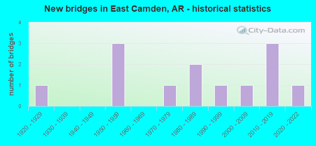
- New bridges - historical statistics
- 11920-1929
- 31950-1959
- 11970-1979
- 21980-1989
- 11990-1999
- 12000-2009
- 32010-2019
- 12020-2022


- Bridge Condition - Deck
- 72.7%Good
- 18.2%Satisfactory
- 9.1%Fair

- Bridge Condition - Superstructure
- 9.1%Excellent
- 9.1%Very good
- 45.5%Good
- 27.3%Satisfactory
- 9.1%Fair

- Bridge Condition - Substructure
- 18.2%Excellent
- 18.2%Very good
- 36.4%Good
- 27.3%Fair

- Bridge Condition - Channel
- 33.3%Very good
- 50.0%Good
- 8.3%Satisfactory
- 8.3%Fair

- Bridge Condition - Culverts
- 50.0%Excellent
- 50.0%Good
Find on map >> Show street view
Structure Number: 1074, Location: 0.65 MI SW JCT US 79&SH4 (Lat: 33.611700, Lng: -92.784431), Route carried "on" structure: Business US 79, Year Built: 1929, Status: Open, Structure Length: 29.90m (98.10ft), Average Daily Traffic: 2,300 (year 2018), Truck Traffic: 2%, Average Future Daily Traffic: 2,500 (year 2038), Design Load: H 15, Features Intersected: MIZZELL CREEK
Minimum Vertical Clearance: 30+ m (98+ ft), Kilometerpoint: 7.548, Lanes on structure: 2, Base Highway Network: Yes, Owner: State Highway Agency, Approaching Roadway Width: 10.4m (34.1ft), Material/Design: Concrete, Design/Construction: Tee Beam, Number Of Spans In Main Unit: 28, Length of Maximum Span: 10.7m (35.1ft), Curb-To-Curb Width: 6.1m (20.0ft), Out-to-Out Width: 6.4m (21.0ft)
Condition: Deck: Fair, Superstructure: Fair, Substructure: Fair, Channel: Good, Operating Rating: 54.4 metric tons, Method Used To Determine Operating Rating: Load Factor (LF), Inventory Rating: 32.7 metric tons, Method Used To Determine Inventory Rating: Load Factor (LF), Structural Evaluation: Somewhat better than minimum adequacy, Deck Geometry: High priority of replacement, Waterway Adequacy: Better than present minimum criteria, Approach Roadway Alignment: Equal to present minimum criteria, Length Of Structure Improvement: 31.12m (102.10ft), Designated Inspection Frequency: Every 24 months, Critical Feature Inspection Frequency: Every 24 months, Other Special Inspection Frequency: Every 24 months, Inspection Date: October 2020, Other Special Inspection Date: October 2021, Roadway Improvement Cost: $156,000, Total Project Cost: $2,252,000, Deck Structure Type: Concrete Cast-file-Place, Wearing Surface/Protective System: Wearing Surface: Bituminous
Find on map >> Show street view
Structure Number: 2721, Location: @ CALHOUN CO LINE (Lat: 33.581519, Lng: -92.710539), Route carried "on" structure: US 278, Year Built: 1950, Status: Open, Structure Length: 9.20m (30.18ft), Average Daily Traffic: 2,469 (year 2018), Truck Traffic: 12%, Average Future Daily Traffic: 2,400 (year 2038), Design Load: H 20, Features Intersected: TWO BAYOU CREEK
Minimum Vertical Clearance: 30+ m (98+ ft), Kilometerpoint: 7.355, Lanes on structure: 2, Base Highway Network: Yes, Owner: State Highway Agency, Approaching Roadway Width: 11.0m (36.1ft), Material/Design: Steel, Design/Construction: Stringer/Multi-beam, Number Of Spans In Main Unit: 10, Length of Maximum Span: 9.1m (29.9ft), Curb-To-Curb Width: 7.9m (25.9ft), Out-to-Out Width: 9.8m (32.2ft)
Condition: Deck: Good, Superstructure: Satisfactory, Substructure: Fair, Channel: Satisfactory, Operating Rating: 44.5 metric tons, Method Used To Determine Operating Rating: Load Factor (LF), Inventory Rating: 26.3 metric tons, Method Used To Determine Inventory Rating: Load Factor (LF), Structural Evaluation: Somewhat better than minimum adequacy, Deck Geometry: High priority of corrective action, Waterway Adequacy: Equal to present minimum criteria, Approach Roadway Alignment: Equal to present desirable criteria, Length Of Structure Improvement: 10.30m (33.79ft), Designated Inspection Frequency: Every 24 months, Critical Feature Inspection Frequency: Every 24 months, Inspection Date: September 2020, Roadway Improvement Cost: $156,000, Total Project Cost: $881,000, Deck Structure Type: Concrete Cast-file-Place, Wearing Surface/Protective System: Wearing Surface: Bituminous
Find on map >> Show street view
Structure Number: 4455, Location: .27 M W JCT CR 88& SH 79 (Lat: 33.652461, Lng: -92.761600), Route carried "on" structure: County highway 88, Year Built: 1983, Status: Open, Structure Length: 5.67m (18.60ft), Average Daily Traffic: 404 (year 2018), Truck Traffic: 1%, Average Future Daily Traffic: 2,755 (year 2007), Design Load: H 20, Features Intersected: PALMER BAYOU
Minimum Vertical Clearance: 30+ m (98+ ft), Kilometerpoint: 9.831, Lanes on structure: 2, Owner: County Highway Agency, Approaching Roadway Width: 12.2m (40.0ft), Material/Design: Concrete, Design/Construction: Slab, Number Of Spans In Main Unit: 6, Length of Maximum Span: 9.4m (30.8ft), Curb-To-Curb Width: 8.5m (27.9ft), Out-to-Out Width: 9.4m (30.8ft)
Condition: Deck: Good, Superstructure: Good, Substructure: Good, Channel: Very good, Operating Rating: 54.4 metric tons, Method Used To Determine Operating Rating: Load Factor (LF), Inventory Rating: 32.7 metric tons, Method Used To Determine Inventory Rating: Load Factor (LF), Structural Evaluation: Better than present minimum criteria, Deck Geometry: Somewhat better than minimum adequacy, Waterway Adequacy: Equal to present desirable criteria, Approach Roadway Alignment: Equal to present desirable criteria, Designated Inspection Frequency: Every 24 months, Critical Feature Inspection Frequency: Every 24 months, Inspection Date: December 2021, Deck Structure Type: Concrete Cast-file-Place, Wearing Surface/Protective System: Wearing Surface: Monolithic Concrete
Find on map >> Show street view
Structure Number: 4456, Location: .2 MI W JCT CR 88&SH79 (Lat: 33.652281, Lng: -92.760481), Route carried "on" structure: County highway 88, Year Built: 1983, Status: Open, Structure Length: 2.83m (9.28ft), Average Daily Traffic: 404 (year 2018), Truck Traffic: 1%, Average Future Daily Traffic: 2,755 (year 2007), Design Load: H 20, Features Intersected: PALMER BAYOU
Minimum Vertical Clearance: 30+ m (98+ ft), Kilometerpoint: 9.944, Lanes on structure: 2, Owner: County Highway Agency, Approaching Roadway Width: 12.2m (40.0ft), Material/Design: Concrete, Design/Construction: Slab, Number Of Spans In Main Unit: 3, Length of Maximum Span: 9.4m (30.8ft), Curb-To-Curb Width: 8.5m (27.9ft), Out-to-Out Width: 9.4m (30.8ft)
Condition: Deck: Good, Superstructure: Good, Substructure: Good, Channel: Very good, Operating Rating: 54.4 metric tons, Method Used To Determine Operating Rating: Load Factor (LF), Inventory Rating: 32.7 metric tons, Method Used To Determine Inventory Rating: Load Factor (LF), Structural Evaluation: Better than present minimum criteria, Deck Geometry: Somewhat better than minimum adequacy, Waterway Adequacy: Better than present minimum criteria, Approach Roadway Alignment: Equal to present desirable criteria, Designated Inspection Frequency: Every 24 months, Critical Feature Inspection Frequency: Every 24 months, Inspection Date: December 2021, Deck Structure Type: Concrete Cast-file-Place, Wearing Surface/Protective System: Wearing Surface: Monolithic Concrete
Find on map >> Show street view
Structure Number: 5627, Location: JCT US 79 & US 278 (Lat: 33.613261, Lng: -92.775019), Route carried "on" structure: US 278, Year Built: 1976, Status: Open, Structure Length: 9.02m (29.59ft), Average Daily Traffic: 8,632 (year 2018), Truck Traffic: 1%, Average Future Daily Traffic: 10,771 (year 2028), Design Load: HS 20, Features Intersected: US 79-SEC 4
Minimum Vertical Clearance: 30+ m (98+ ft), Kilometerpoint: 0.225, Lanes on structure: 2, Lanes under structure: 4, Base Highway Network: Yes, Owner: State Highway Agency, Approaching Roadway Width: 17.1m (56.1ft), Skew: 4 degrees, Material/Design: Steel continuous, Design/Construction: Stringer/Multi-beam, Number Of Spans In Main Unit: 3, Length of Maximum Span: 37.5m (123.0ft), Curb-To-Curb Width: 16.8m (55.1ft), Out-to-Out Width: 17.7m (58.1ft)
Condition: Deck: Good, Superstructure: Good, Substructure: Very good, Operating Rating: 48.1 metric tons, Method Used To Determine Operating Rating: Load Factor (LF), Inventory Rating: 29.0 metric tons, Method Used To Determine Inventory Rating: Load Factor (LF), Structural Evaluation: Better than present minimum criteria, Deck Geometry: Superior to present desirable criteria, Underclear: Meets minimum limits, Approach Roadway Alignment: Equal to present desirable criteria, Designated Inspection Frequency: Every 24 months, Critical Feature Inspection Frequency: Every 24 months, Inspection Date: March 2020, Deck Structure Type: Concrete Cast-file-Place, Wearing Surface/Protective System: Wearing Surface: Monolithic Concrete
Find on map >> Show street view
Structure Number: 6392, Location: 1.42 MI N JCT SH 274&205 (Lat: 33.649508, Lng: -92.701839), Route carried "on" structure: State highway 205, Year Built: 1992, Status: Open, Structure Length: 3.20m (10.50ft), Average Daily Traffic: 870 (year 2018), Truck Traffic: 1%, Average Future Daily Traffic: 955 (year 2028), Design Load: HS 20, Features Intersected: CREEK
Minimum Vertical Clearance: 30+ m (98+ ft), Kilometerpoint: 2.285, Lanes on structure: 2, Owner: State Highway Agency, Approaching Roadway Width: 13.7m (44.9ft), Material/Design: Concrete, Design/Construction: Tee Beam, Number Of Spans In Main Unit: 3, Length of Maximum Span: 10.7m (35.1ft), Curb-To-Curb Width: 9.2m (30.2ft), Out-to-Out Width: 10.0m (32.8ft)
Condition: Deck: Good, Superstructure: Very good, Substructure: Very good, Channel: Good, Operating Rating: 54.4 metric tons, Method Used To Determine Operating Rating: Load Factor (LF), Inventory Rating: 32.7 metric tons, Method Used To Determine Inventory Rating: Load Factor (LF), Structural Evaluation: Equal to present desirable criteria, Deck Geometry: Equal to present minimum criteria, Waterway Adequacy: Better than present minimum criteria, Approach Roadway Alignment: Equal to present desirable criteria, Designated Inspection Frequency: Every 24 months, Critical Feature Inspection Frequency: Every 24 months, Inspection Date: March 2020, Deck Structure Type: Concrete Cast-file-Place, Wearing Surface/Protective System: Wearing Surface: Monolithic Concrete
Find on map >> Show street view
Structure Number: 7209, Location: 1.8 MI E Ouachita Co. Ln (Lat: 33.629789, Lng: -92.709297), Route carried "on" structure: State highway 274, Year Built: 2012, Status: Open, Structure Length: 3.81m (12.50ft), Average Daily Traffic: 4,100 (year 2018), Truck Traffic: 9%, Average Future Daily Traffic: 4,200 (year 2031), Design Load: HL 93, Features Intersected: Ditch
Minimum Vertical Clearance: 30+ m (98+ ft), Kilometerpoint: 2.913, Lanes on structure: 2, Owner: State Highway Agency, Approaching Roadway Width: 12.2m (40.0ft), Material/Design: Steel continuous, Design/Construction: Stringer/Multi-beam, Number Of Spans In Main Unit: 3, Length of Maximum Span: 14.0m (45.9ft), Curb-To-Curb Width: 12.2m (40.0ft), Out-to-Out Width: 13.2m (43.3ft)
Condition: Deck: Good, Superstructure: Excellent, Substructure: Excellent, Channel: Very good, Operating Rating: 54.4 metric tons, Method Used To Determine Operating Rating: Load and Resistance Factor (LRFR), Inventory Rating: 32.7 metric tons, Method Used To Determine Inventory Rating: Load and Resistance Factor (LRFR), Structural Evaluation: Superior to present desirable criteria, Deck Geometry: Equal to present minimum criteria, Waterway Adequacy: Superior to present desirable criteria, Approach Roadway Alignment: Equal to present desirable criteria, Designated Inspection Frequency: Every 24 months, Critical Feature Inspection Frequency: Every 24 months, Inspection Date: December 2020, Deck Structure Type: Concrete Cast-file-Place, Wearing Surface/Protective System: Wearing Surface: Monolithic Concrete
Find on map >> Show street view
Structure Number: 10919, Location: .7 MI W SH 205 (Lat: 33.639497, Lng: -92.710836), Route carried "on" structure: State highway 203, Year Built: 1955, Status: Open, Structure Length: 3.90m (12.80ft), Average Daily Traffic: 780 (year 2018), Truck Traffic: 1%, Average Future Daily Traffic: 836 (year 2028), Design Load: H 15, Features Intersected: TWO BAYOU CREEK
Minimum Vertical Clearance: 30+ m (98+ ft), Kilometerpoint: 11.829, Lanes on structure: 2, Owner: State Highway Agency, Approaching Roadway Width: 8.5m (27.9ft), Skew: 3 degrees, Material/Design: Wood or Timber, Design/Construction: Stringer/Multi-beam, Number Of Spans In Main Unit: 9, Length of Maximum Span: 4.3m (14.1ft), Curb-To-Curb Width: 8.5m (27.9ft), Out-to-Out Width: 8.9m (29.2ft)
Condition: Deck: Satisfactory, Superstructure: Good, Substructure: Fair, Channel: Good, Operating Rating: 45.4 metric tons, Method Used To Determine Operating Rating: Allowable Stress (AS), Inventory Rating: 31.8 metric tons, Method Used To Determine Inventory Rating: Allowable Stress (AS), Structural Evaluation: Somewhat better than minimum adequacy, Deck Geometry: Somewhat better than minimum adequacy, Waterway Adequacy: Better than present minimum criteria, Approach Roadway Alignment: Better than present minimum criteria, Designated Inspection Frequency: Every 24 months, Critical Feature Inspection Frequency: Every 24 months, Inspection Date: July 2020, Deck Structure Type: Concrete Cast-file-Place, Wearing Surface/Protective System: Wearing Surface: Monolithic Concrete
Find on map >> Show street view
Structure Number: 23439, Location: .95 mi. NE SH 7 (Lat: 33.644369, Lng: -92.788672), Route carried "on" structure: County highway 43, Year Built: 2012, Status: Posted for load, Structure Length: 0.67m (2.20ft), Average Daily Traffic: 360 (year 2018), Truck Traffic: 2%, Average Future Daily Traffic: 400 (year 2038), Features Intersected: Creek
Minimum Vertical Clearance: 30+ m (98+ ft), Kilometerpoint: 1.529, Lanes on structure: 1, Owner: County Highway Agency, Approaching Roadway Width: 7.9m (25.9ft), Material/Design: Steel, Design/Construction: Stringer/Multi-beam, Number Of Spans In Main Unit: 2, Length of Maximum Span: 3.0m (9.8ft), Curb-To-Curb Width: 6.8m (22.3ft), Out-to-Out Width: 7.4m (24.3ft)
Condition: Deck: Good, Superstructure: Satisfactory, Substructure: Good, Channel: Fair, Operating Rating: 15.4 metric tons, Method Used To Determine Operating Rating: Load Factor (LF), Inventory Rating: 9.1 metric tons, Method Used To Determine Inventory Rating: Load Factor (LF), Structural Evaluation: High priority of corrective action, Deck Geometry: Meets minimum limits, Waterway Adequacy: Somewhat better than minimum adequacy, Approach Roadway Alignment: Somewhat better than minimum adequacy, Bridge Posting: Required (Relationship of Operating Rating to Maximum Legal Load: > 39.9% below), Designated Inspection Frequency: Every 24 months, Critical Feature Inspection Frequency: Every 24 months, Inspection Date: June 2021, Deck Structure Type: Wood or Timber, Wearing Surface/Protective System: Wearing Surface: Bituminous
Find on map >> Show street view
Structure Number: 24087, Location: 1.76 Mi N Jct US 79B (Lat: 33.635089, Lng: -92.772369), Route carried "on" structure: County highway 45, Year Built: 2019, Status: Open, Structure Length: 2.31m (7.58ft), Average Daily Traffic: 362 (year 2018), Truck Traffic: 1%, Average Future Daily Traffic: 109 (year 2007), Features Intersected: Mizzel Creek
Minimum Vertical Clearance: 30+ m (98+ ft), Kilometerpoint: 2.832, Lanes on structure: 2, Owner: County Highway Agency, Approaching Roadway Width: 6.7m (22.0ft), Material/Design: Steel, Design/Construction: Stringer/Multi-beam, Number Of Spans In Main Unit: 3, Length of Maximum Span: 8.2m (26.9ft), Curb-To-Curb Width: 6.6m (21.7ft), Out-to-Out Width: 6.6m (21.7ft)
Condition: Deck: Good, Superstructure: Good, Substructure: Excellent, Channel: Good, Operating Rating: 43.5 metric tons, Method Used To Determine Operating Rating: Load Factor (LF), Inventory Rating: 26.3 metric tons, Method Used To Determine Inventory Rating: Load Factor (LF), Structural Evaluation: Equal to present minimum criteria, Deck Geometry: Meets minimum limits, Waterway Adequacy: Equal to present minimum criteria, Approach Roadway Alignment: Better than present minimum criteria, Designated Inspection Frequency: Every 24 months, Critical Feature Inspection Frequency: Every 24 months, Inspection Date: October 2021, Deck Structure Type: Concrete Cast-file-Place, Wearing Surface/Protective System: Wearing Surface: Monolithic Concrete
Find on map >> Show street view
Structure Number: M2643, Location: 1.0 MI S JCT 205 & 274 (Lat: 33.619586, Lng: -92.692519), Route carried "on" structure: State highway 274, Year Built: 1950, Status: Posted for load, Structure Length: 2.62m (8.60ft), Average Daily Traffic: 1,576 (year 2018), Truck Traffic: 1%, Average Future Daily Traffic: 1,671 (year 2028), Design Load: H 15, Features Intersected: DITCH
Minimum Vertical Clearance: 30+ m (98+ ft), Kilometerpoint: 5.390, Lanes on structure: 2, Owner: State Highway Agency, Approaching Roadway Width: 12.2m (40.0ft), Material/Design: Wood or Timber, Design/Construction: Stringer/Multi-beam, Number Of Spans In Main Unit: 6, Length of Maximum Span: 4.6m (15.1ft), Curb-To-Curb Width: 8.5m (27.9ft), Out-to-Out Width: 8.9m (29.2ft)
Condition: Deck: Satisfactory, Superstructure: Satisfactory, Substructure: Good, Channel: Good, Operating Rating: 26.3 metric tons, Method Used To Determine Operating Rating: Allowable Stress (AS), Inventory Rating: 19.1 metric tons, Method Used To Determine Inventory Rating: Allowable Stress (AS), Structural Evaluation: Somewhat better than minimum adequacy, Deck Geometry: Somewhat better than minimum adequacy, Waterway Adequacy: Better than present minimum criteria, Approach Roadway Alignment: Better than present minimum criteria, Bridge Posting: Required (Relationship of Operating Rating to Maximum Legal Load: 20.0 - 29.9% below), Length Of Structure Improvement: 3.41m (11.19ft), Designated Inspection Frequency: Every 24 months, Critical Feature Inspection Frequency: Every 24 months, Inspection Date: April 2020, Roadway Improvement Cost: $117,000, Total Project Cost: $319,000, Deck Structure Type: Concrete Cast-file-Place, Wearing Surface/Protective System: Wearing Surface: Bituminous
Find on map >> Show street view
Structure Number: X1053, Location: .85 E of US 79 (Lat: 33.666889, Lng: -92.729189), Route carried "on" structure: State highway 205, Year Built: 2001, Status: Open, Structure Length: 1.46m (4.79ft), Average Daily Traffic: 870 (year 2018), Truck Traffic: 1%, Average Future Daily Traffic: 917 (year 2028), Design Load: H 20, Features Intersected: Mizzell Creek
Minimum Vertical Clearance: 30+ m (98+ ft), Kilometerpoint: 3.862, Lanes on structure: 2, Owner: State Highway Agency, Approaching Roadway Width: 10.4m (34.1ft), Material/Design: Concrete, Design/Construction: Culvert, Number Of Spans In Main Unit: 4, Length of Maximum Span: 3.4m (11.2ft), Curb-To-Curb Width: 16.8m (55.1ft), Out-to-Out Width: 17.4m (57.1ft)
Condition: Channel: Good, Culverts: Good, Operating Rating: 29.0 metric tons, Method Used To Determine Operating Rating: Load Factor (LF), Inventory Rating: 17.2 metric tons, Method Used To Determine Inventory Rating: Load Factor (LF), Structural Evaluation: Meets minimum limits, Deck Geometry: Superior to present desirable criteria, Waterway Adequacy: Equal to present minimum criteria, Approach Roadway Alignment: Equal to present desirable criteria, Designated Inspection Frequency: Every 24 months, Critical Feature Inspection Frequency: Every 24 months, Inspection Date: November 2021
Find on map >> Show street view
Structure Number: X16, Location: 1.55 MI E Jct US 278 (Lat: 33.616056, Lng: -92.732956), Route carried "on" structure: State highway 274, Year Built: 2021, Status: Open, Structure Length: 1.80m (5.91ft), Average Daily Traffic: 5,000 (year 2014), Truck Traffic: 1%, Average Future Daily Traffic: 1,100 (year 2028), Design Load: HL 93, Features Intersected: TWO BAYOU CREEK
Minimum Vertical Clearance: 30+ m (98+ ft), Kilometerpoint: 2.494, Lanes on structure: 2, Owner: State Highway Agency, Approaching Roadway Width: 11.6m (38.1ft), Material/Design: Concrete, Design/Construction: Culvert, Number Of Spans In Main Unit: 5, Length of Maximum Span: 3.4m (11.2ft)
Condition: Channel: Very good, Culverts: Excellent, Operating Rating: 54.4 metric tons, Method Used To Determine Operating Rating: Load and Resistance Factor (LRFR), Inventory Rating: 32.7 metric tons, Method Used To Determine Inventory Rating: Load and Resistance Factor (LRFR), Structural Evaluation: Superior to present desirable criteria, Waterway Adequacy: Equal to present minimum criteria, Approach Roadway Alignment: Equal to present desirable criteria, Designated Inspection Frequency: Every 24 months, Critical Feature Inspection Frequency: Every 24 months, Inspection Date: Febuary 2021
Find on map >> Show street view
Structure Number: 535, Location: 0.3 MI SW JCT US 79B/SH 4 (Lat: 33.606669, Lng: -92.782639), Route carried "under" structure: County highway 202, Structure Length: 0. m, Average Daily Traffic: 31 (year 1983), Truck Traffic: 1%, Features Intersected: Woodard Lake & CR 202, Facility Carried by Structure: US 79 S-4 LM 4.43
Minimum Vertical Clearance: 4.87m (15.98ft), Kilometerpoint: 0.048, Length of Maximum Span: 0.0m
Find on map >> Show street view
Structure Number: 5627, Location: JCT US 79 & US 278 (Lat: 33.613261, Lng: -92.775019), Route carried "under" structure: US 79, Structure Length: 0. m, Average Daily Traffic: 3,600 (year 2014), Truck Traffic: 1%, Features Intersected: US 79-SEC 4, Facility Carried by Structure: US 278 S-9 LM 0.14
Minimum Vertical Clearance: 5.13m (16.83ft), Kilometerpoint: 8.143, Length of Maximum Span: 0.0m