Bridge Statistics for East Farmingdale, New York (NY)
Condition, Traffic, Stress, Structural Evaluation, Project Costs
- National Bridge Inventory (NBI) Statistics
- 18Number of bridges
- 69ft / 20.6mTotal length
- $52,497,000Total costs
- 1,448,216Total average daily traffic
- 13,038Total average daily truck traffic
- National Bridge Inventory (NBI) Registered Bridges for East Farmingdale
- No street view available for this location
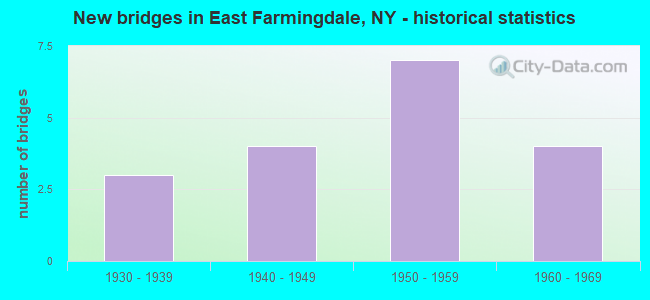
- New bridges - historical statistics
- 31930-1939
- 41940-1949
- 71950-1959
- 41960-1969
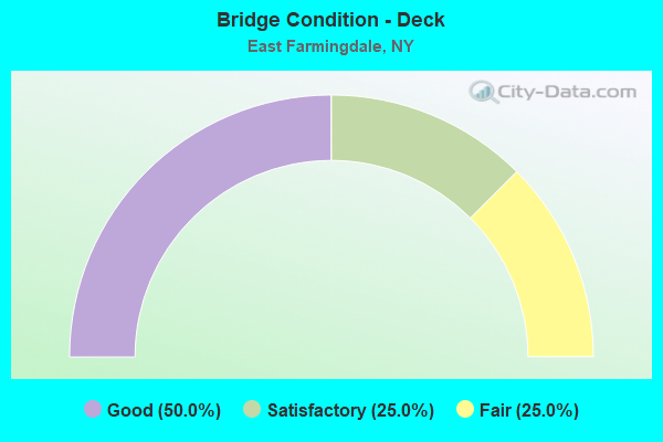
- Bridge Condition - Deck
- 50.0%Good
- 25.0%Satisfactory
- 25.0%Fair
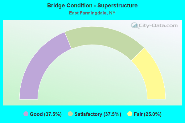
- Bridge Condition - Superstructure
- 37.5%Good
- 37.5%Satisfactory
- 25.0%Fair
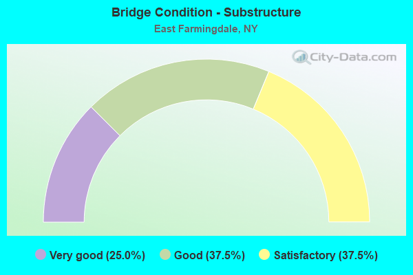
- Bridge Condition - Substructure
- 25.0%Very good
- 37.5%Good
- 37.5%Satisfactory
Find on map >> Show street view
Structure Number: 1036929, Location: JCT RTS 109+SSP (Lat: 40.718067, Lng: -73.407917), Route carried "on" structure: State highway 109, Year Built: 1940, Status: Open, Structure Length: 2.10m (6.89ft), Average Daily Traffic: 37,252 (year 2020), Truck Traffic: 9%, Average Future Daily Traffic: 42,981 (year 2040), Features Intersected: RTE 908M
Minimum Vertical Clearance: 30+ m (98+ ft), Kilometerpoint: 2.253, Lanes on structure: 6, Lanes under structure: 4, Base Highway Network: Yes, Owner: State Highway Agency, Approaching Roadway Width: 22.6m (74.1ft), Skew: 22 degrees, Material/Design: Concrete, Design/Construction: Arch - Deck, Number Of Spans In Main Unit: 1, Length of Maximum Span: 19.2m (63.0ft), Curb or Sidewalk Widths: Left: 1.5m (4.9ft), Right: 1.5m (4.9ft), Curb-To-Curb Width: 22.6m (74.1ft), Out-to-Out Width: 27.7m (90.9ft)
Condition: Superstructure: Satisfactory, Substructure: Satisfactory, Operating Rating: 89.8 metric tons, Method Used To Determine Operating Rating: Load Factor (LF), Inventory Rating: 68.9 metric tons, Method Used To Determine Inventory Rating: Load Factor (LF), Structural Evaluation: Equal to present minimum criteria, Deck Geometry: Meets minimum limits, Underclear: High priority of corrective action, Approach Roadway Alignment: Equal to present desirable criteria, Length Of Structure Improvement: 2.10m (6.89ft), Designated Inspection Frequency: Every 24 months, Inspection Date: November 2021, Bridge Improvement Cost: $4,911,000, Roadway Improvement Cost: $2,876,000, Total Project Cost: $7,786,000 ( Estimate for 2021)
Find on map >> Show street view
Structure Number: 1036939, Location: JCT RTS 109+110 (Lat: 40.722714, Lng: -73.424861), Route carried "on" structure: State highway 110, Year Built: 1956, Status: Open, Structure Length: 5.55m (18.21ft), Average Daily Traffic: 36,426 (year 2019), Truck Traffic: 5%, Average Future Daily Traffic: 42,028 (year 2040), Design Load: H 20, Features Intersected: 109 109 0701 1054, E/B,
Minimum Vertical Clearance: 30+ m (98+ ft), Kilometerpoint: 5.953, Lanes on structure: 6, Lanes under structure: 6, Base Highway Network: Yes, Owner: State Highway Agency, Approaching Roadway Width: 23.2m (76.1ft), Skew: 20 degrees, Material/Design: Steel, Design/Construction: Stringer/Multi-beam, Number Of Spans In Main Unit: 4, Length of Maximum Span: 17.0m (55.8ft), Curb or Sidewalk Widths: Left: 1.2m (3.9ft), Right: 1.2m (3.9ft), Curb-To-Curb Width: 23.2m (76.1ft), Out-to-Out Width: 27.5m (90.2ft)
Condition: Deck: Satisfactory, Superstructure: Fair, Substructure: Satisfactory, Operating Rating: 51.7 metric tons, Method Used To Determine Operating Rating: Load Factor (LF), Inventory Rating: 30.8 metric tons, Method Used To Determine Inventory Rating: Load Factor (LF), Structural Evaluation: Somewhat better than minimum adequacy, Deck Geometry: Meets minimum limits, Underclear: High priority of corrective action, Approach Roadway Alignment: Equal to present minimum criteria, Length Of Structure Improvement: 5.54m (18.18ft), Designated Inspection Frequency: Every 24 months, Inspection Date: June 2021, Bridge Improvement Cost: $5,818,000, Roadway Improvement Cost: $3,407,000, Total Project Cost: $9,225,000 ( Estimate for 2021), Deck Structure Type: Concrete Cast-file-Place, Wearing Surface/Protective System: Wearing Surface: Bituminous
Find on map >> Show street view
Structure Number: 1036959, Location: .1 MI S JCT RTS 109+110 (Lat: 40.721561, Lng: -73.425458), Route carried "on" structure: State highway 110, Year Built: 1956, Status: Open, Structure Length: 1.55m (5.09ft), Average Daily Traffic: 36,426 (year 2019), Truck Traffic: 3%, Average Future Daily Traffic: 42,028 (year 2040), Design Load: HS 20, Features Intersected: LIRR-CENTRAL BRCH
Minimum Vertical Clearance: 30+ m (98+ ft), Kilometerpoint: 5.841, Lanes on structure: 6, Base Highway Network: Yes, Owner: State Highway Agency, Approaching Roadway Width: 23.0m (75.5ft), Skew: 20 degrees, Material/Design: Concrete, Design/Construction: Frame, Number Of Spans In Main Unit: 1, Length of Maximum Span: 13.1m (43.0ft), Curb or Sidewalk Widths: Left: 1.5m (4.9ft), Right: 1.5m (4.9ft), Curb-To-Curb Width: 23.0m (75.5ft), Out-to-Out Width: 27.5m (90.2ft)
Condition: Deck: Good, Superstructure: Good, Substructure: Good, Operating Rating: 67.1 metric tons, Method Used To Determine Operating Rating: Load Factor (LF), Inventory Rating: 39.9 metric tons, Method Used To Determine Inventory Rating: Load Factor (LF), Structural Evaluation: Better than present minimum criteria, Deck Geometry: Meets minimum limits, Underclear: Somewhat better than minimum adequacy, Approach Roadway Alignment: Equal to present desirable criteria, Length Of Structure Improvement: 1.55m (5.09ft), Designated Inspection Frequency: Every 24 months, Inspection Date: September 2020, Bridge Improvement Cost: $3,987,000, Roadway Improvement Cost: $2,335,000, Total Project Cost: $6,321,000 ( Estimate for 2021), Wearing Surface/Protective System: Wearing Surface: Bituminous, Membrane: Preformed Fabric
Find on map >> Show street view
Structure Number: 105775, Location: .1 MI N JCT SH 109 & SSP (Lat: 40.719361, Lng: -73.406658), Route carried "on" structure: City street , Year Built: 1959, Status: Open, Structure Length: 2.35m (7.71ft), Average Daily Traffic: 7,970 (year 2020), Truck Traffic: 6%, Average Future Daily Traffic: 9,681 (year 2040), Design Load: H 20, Features Intersected: RTE 908M, Facility Carried by Structure: NEW HIGHWAY
Minimum Vertical Clearance: 30+ m (98+ ft), Kilometerpoint: 0.064, Lanes on structure: 3, Lanes under structure: 4, Owner: State Highway Agency, Approaching Roadway Width: 12.2m (40.0ft), Skew: 1 degrees, Material/Design: Concrete, Design/Construction: Frame, Number Of Spans In Main Unit: 1, Length of Maximum Span: 19.5m (64.0ft), Curb or Sidewalk Widths: Left: 1.5m (4.9ft), Right: 1.5m (4.9ft), Curb-To-Curb Width: 12.2m (40.0ft), Out-to-Out Width: 16.2m (53.1ft)
Condition: Deck: Good, Superstructure: Good, Substructure: Very good, Operating Rating: 58.0 metric tons, Method Used To Determine Operating Rating: Field evaluation and documented engineering judgment, Inventory Rating: 22.9 metric tons, Method Used To Determine Inventory Rating: Field evaluation and documented engineering judgment, Structural Evaluation: Somewhat better than minimum adequacy, Deck Geometry: Meets minimum limits, Underclear: High priority of corrective action, Approach Roadway Alignment: Better than present minimum criteria, Length Of Structure Improvement: 2.34m (7.68ft), Designated Inspection Frequency: Every 24 months, Inspection Date: November 2020, Bridge Improvement Cost: $2,150,000, Roadway Improvement Cost: $1,259,000, Total Project Cost: $3,408,000 ( Estimate for 2021), Wearing Surface/Protective System: Wearing Surface: Bituminous, Membrane: Preformed Fabric
Find on map >> Show street view
Structure Number: 105776, Location: .7 MI E JCT SH 109 & SSP (Lat: 40.721394, Lng: -73.394553), Route carried "on" structure: County highway , Year Built: 1960, Year Reconstructed: 2008, Status: Open, Structure Length: 2.32m (7.61ft), Average Daily Traffic: 23,923 (year 2018), Truck Traffic: 5%, Average Future Daily Traffic: 29,061 (year 2040), Design Load: HS 20, Features Intersected: RTE 908M, Facility Carried by Structure: WELLWOOD AVENUE
Minimum Vertical Clearance: 30+ m (98+ ft), Kilometerpoint: 2.993, Lanes on structure: 6, Lanes under structure: 4, Owner: State Highway Agency, Approaching Roadway Width: 20.4m (66.9ft), Material/Design: Concrete, Design/Construction: Arch - Deck, Number Of Spans In Main Unit: 1, Length of Maximum Span: 21.0m (68.9ft), Curb or Sidewalk Widths: Left: 1.7m (5.6ft), Right: 1.7m (5.6ft), Curb-To-Curb Width: 20.4m (66.9ft), Out-to-Out Width: 25.3m (83.0ft)
Condition: Superstructure: Satisfactory, Substructure: Good, Operating Rating: 86.1 metric tons, Method Used To Determine Operating Rating: Field evaluation and documented engineering judgment, Inventory Rating: 29.4 metric tons, Method Used To Determine Inventory Rating: Field evaluation and documented engineering judgment, Structural Evaluation: Equal to present minimum criteria, Deck Geometry: High priority of replacement, Underclear: High priority of corrective action, Approach Roadway Alignment: Equal to present desirable criteria, Length Of Structure Improvement: 2.31m (7.58ft), Designated Inspection Frequency: Every 24 months, Inspection Date: November 2020, Bridge Improvement Cost: $4,572,000, Roadway Improvement Cost: $2,677,000, Total Project Cost: $7,249,000 ( Estimate for 2021), Wearing Surface/Protective System: Wearing Surface: Monolithic Concrete
Find on map >> Show street view
Structure Number: 1057929, Location: JCT RTS 109+SSP (Lat: 40.718197, Lng: -73.408156), Route carried "on" structure: State highway 109, Year Built: 1961, Status: Open, Structure Length: 2.41m (7.91ft), Average Daily Traffic: 32,755 (year 2020), Truck Traffic: 9%, Average Future Daily Traffic: 37,792 (year 2040), Design Load: H 20, Features Intersected: RTE 908M
Minimum Vertical Clearance: 30+ m (98+ ft), Kilometerpoint: 2.269, Lanes on structure: 6, Lanes under structure: 4, Base Highway Network: Yes, Owner: State Highway Agency, Approaching Roadway Width: 22.6m (74.1ft), Skew: 22 degrees, Material/Design: Concrete, Design/Construction: Arch - Deck, Number Of Spans In Main Unit: 1, Length of Maximum Span: 22.5m (73.8ft), Curb or Sidewalk Widths: Left: 1.5m (4.9ft), Right: 1.5m (4.9ft), Curb-To-Curb Width: 22.6m (74.1ft), Out-to-Out Width: 27.7m (90.9ft)
Condition: Superstructure: Satisfactory, Substructure: Satisfactory, Operating Rating: 89.8 metric tons, Method Used To Determine Operating Rating: Load Factor (LF), Inventory Rating: 40.8 metric tons, Method Used To Determine Inventory Rating: Load Factor (LF), Structural Evaluation: Equal to present minimum criteria, Deck Geometry: Meets minimum limits, Underclear: High priority of corrective action, Approach Roadway Alignment: Equal to present desirable criteria, Length Of Structure Improvement: 2.40m (7.87ft), Designated Inspection Frequency: Every 24 months, Inspection Date: November 2021, Bridge Improvement Cost: $5,480,000, Roadway Improvement Cost: $3,209,000, Total Project Cost: $8,689,000 ( Estimate for 2021)
Find on map >> Show street view
Structure Number: 105975, Location: .1 MI N JCT SH 109 & SSP (Lat: 40.719128, Lng: -73.406542), Route carried "on" structure: City street , Year Built: 1941, Status: Open, Structure Length: 2.35m (7.71ft), Average Daily Traffic: 7,970 (year 2020), Truck Traffic: 6%, Average Future Daily Traffic: 9,681 (year 2040), Design Load: H 20, Features Intersected: RTE 908M, Facility Carried by Structure: NEW HIGHWAY
Minimum Vertical Clearance: 30+ m (98+ ft), Kilometerpoint: 0.016, Lanes on structure: 3, Lanes under structure: 4, Owner: State Highway Agency, Approaching Roadway Width: 12.2m (40.0ft), Skew: 1 degrees, Material/Design: Concrete, Design/Construction: Frame, Number Of Spans In Main Unit: 1, Length of Maximum Span: 21.9m (71.9ft), Curb or Sidewalk Widths: Left: 1.5m (4.9ft), Right: 1.5m (4.9ft), Curb-To-Curb Width: 12.2m (40.0ft), Out-to-Out Width: 16.2m (53.1ft)
Condition: Deck: Fair, Superstructure: Fair, Substructure: Good, Operating Rating: 59.9 metric tons, Method Used To Determine Operating Rating: Field evaluation and documented engineering judgment, Inventory Rating: 21.2 metric tons, Method Used To Determine Inventory Rating: Field evaluation and documented engineering judgment, Structural Evaluation: Somewhat better than minimum adequacy, Deck Geometry: Meets minimum limits, Underclear: High priority of corrective action, Approach Roadway Alignment: Better than present minimum criteria, Length Of Structure Improvement: 2.34m (7.68ft), Designated Inspection Frequency: Every 24 months, Inspection Date: November 2020, Bridge Improvement Cost: $2,150,000, Roadway Improvement Cost: $1,259,000, Total Project Cost: $3,408,000 ( Estimate for 2021), Wearing Surface/Protective System: Wearing Surface: Bituminous, Membrane: Preformed Fabric
Find on map >> Show street view
Structure Number: 105976, Location: .7 MI E JCT SH 109 & SSP (Lat: 40.721228, Lng: -73.394478), Route carried "on" structure: County highway , Year Built: 1934, Year Reconstructed: 2008, Status: Open, Structure Length: 2.01m (6.59ft), Average Daily Traffic: 23,923 (year 2020), Truck Traffic: 7%, Average Future Daily Traffic: 29,061 (year 2040), Design Load: H 20, Features Intersected: RTE 908M, Facility Carried by Structure: WELLWOOD AVENUE
Minimum Vertical Clearance: 30+ m (98+ ft), Kilometerpoint: 2.961, Lanes on structure: 6, Lanes under structure: 4, Owner: State Highway Agency, Approaching Roadway Width: 20.4m (66.9ft), Material/Design: Concrete, Design/Construction: Arch - Deck, Number Of Spans In Main Unit: 1, Length of Maximum Span: 18.3m (60.0ft), Curb or Sidewalk Widths: Left: 1.7m (5.6ft), Right: 1.7m (5.6ft), Curb-To-Curb Width: 20.4m (66.9ft), Out-to-Out Width: 25.2m (82.7ft)
Condition: Superstructure: Good, Substructure: Very good, Operating Rating: 55.9 metric tons, Method Used To Determine Operating Rating: Field evaluation and documented engineering judgment, Inventory Rating: 20.3 metric tons, Method Used To Determine Inventory Rating: Field evaluation and documented engineering judgment, Structural Evaluation: Somewhat better than minimum adequacy, Deck Geometry: High priority of replacement, Underclear: High priority of corrective action, Approach Roadway Alignment: Equal to present desirable criteria, Length Of Structure Improvement: 2.01m (6.59ft), Designated Inspection Frequency: Every 24 months, Inspection Date: November 2020, Bridge Improvement Cost: $4,043,000, Roadway Improvement Cost: $2,368,000, Total Project Cost: $6,411,000 ( Estimate for 2021), Wearing Surface/Protective System: Wearing Surface: Monolithic Concrete
Find on map >> Show street view
Structure Number: 1036929, Location: JCT RTS 109+SSP (Lat: 40.718067, Lng: -73.407917), Route carried "under" structure: State highway 908M, Year Built: 1940, Structure Length: 0. m, Average Daily Traffic: 147,331 (year 2002), Features Intersected: RTE 908M, Facility Carried by Structure: RTE 109
Minimum Vertical Clearance: 4.24m (13.91ft), Kilometerpoint: 2.494, Lanes on structure: 6, Lanes under structure: 4, Material/Design: Concrete, Design/Construction: Arch - Deck, Length of Maximum Span: 19.2m (63.0ft)
Find on map >> Show street view
Structure Number: 1036939, Location: JCT RTS 109+110 (Lat: 40.722714, Lng: -73.424861), Route carried "under" structure: State highway 109, Year Built: 1956, Structure Length: 0. m, Average Daily Traffic: 33,109 (year 1985), Features Intersected: 109 109 0701 1054, E/B,, Facility Carried by Structure: RTE 110
Minimum Vertical Clearance: 4.60m (15.09ft), Kilometerpoint: 8.785, Lanes on structure: 6, Lanes under structure: 3, Material/Design: Steel, Design/Construction: Stringer/Multi-beam, Length of Maximum Span: 17.0m (55.8ft)
Find on map >> Show street view
Structure Number: 105775, Location: .1 MI N JCT SH 109 & SSP (Lat: 40.719361, Lng: -73.406658), Route carried "under" structure: State highway 908M, Year Built: 1959, Structure Length: 0. m, Average Daily Traffic: 147,331 (year 2002), Features Intersected: RTE 908M, Facility Carried by Structure: NEW HIGHWAY
Minimum Vertical Clearance: 4.27m (14.01ft), Kilometerpoint: 2.623, Lanes on structure: 3, Lanes under structure: 4, Material/Design: Concrete, Design/Construction: Frame, Length of Maximum Span: 19.5m (64.0ft)
Find on map >> Show street view
Structure Number: 105776, Location: .7 MI E JCT SH 109 & SSP (Lat: 40.721394, Lng: -73.394553), Route carried "under" structure: State highway 908M, Year Built: 1960, Structure Length: 0. m, Average Daily Traffic: 136,975 (year 2002), Features Intersected: RTE 908M, Facility Carried by Structure: WELLWOOD AVENUE
Minimum Vertical Clearance: 4.09m (13.42ft), Kilometerpoint: 3.701, Lanes on structure: 6, Lanes under structure: 4, Material/Design: Concrete, Design/Construction: Arch - Deck, Length of Maximum Span: 21.0m (68.9ft)
Find on map >> Show street view
Structure Number: 1057929, Location: JCT RTS 109+SSP (Lat: 40.718197, Lng: -73.408156), Route carried "under" structure: State highway 908M, Year Built: 1961, Structure Length: 0. m, Average Daily Traffic: 147,331 (year 2002), Features Intersected: RTE 908M, Facility Carried by Structure: RTE 109
Minimum Vertical Clearance: 4.17m (13.68ft), Kilometerpoint: 2.494, Lanes on structure: 6, Lanes under structure: 4, Material/Design: Concrete, Design/Construction: Arch - Deck, Length of Maximum Span: 22.5m (73.8ft)
Find on map >> Show street view
Structure Number: 105975, Location: .1 MI N JCT SH 109 & SSP (Lat: 40.719128, Lng: -73.406542), Route carried "under" structure: State highway 908M, Year Built: 1941, Structure Length: 0. m, Average Daily Traffic: 147,331 (year 2002), Features Intersected: RTE 908M, Facility Carried by Structure: NEW HIGHWAY
Minimum Vertical Clearance: 3.99m (13.09ft), Kilometerpoint: 2.623, Lanes on structure: 3, Lanes under structure: 4, Material/Design: Concrete, Design/Construction: Frame, Length of Maximum Span: 21.9m (71.9ft)
Find on map >> Show street view
Structure Number: 105976, Location: .7 MI E JCT SH 109 & SSP (Lat: 40.721228, Lng: -73.394478), Route carried "under" structure: State highway 908M, Year Built: 1934, Structure Length: 0. m, Average Daily Traffic: 136,975 (year 2002), Features Intersected: RTE 908M, Facility Carried by Structure: WELLWOOD AVENUE
Minimum Vertical Clearance: 4.62m (15.16ft), Kilometerpoint: 3.701, Lanes on structure: 6, Lanes under structure: 4, Material/Design: Concrete, Design/Construction: Arch - Deck, Length of Maximum Span: 18.3m (60.0ft)
Find on map >> Show street view
Structure Number: 703697, Location: 1.2 MI N JCT RTS 109+110 (Lat: 40.739992, Lng: -73.423161), Route carried "under" structure: State highway 110, Year Built: 1958, Structure Length: 0. m, Average Daily Traffic: 58,384 (year 2002), Features Intersected: RTE 110, Facility Carried by Structure: LONG ISLAND
Minimum Vertical Clearance: 4.39m (14.40ft), Kilometerpoint: 7.997, Lanes under structure: 6, Material/Design: Steel, Design/Construction: Girder and Floorbeam System, Length of Maximum Span: 20.4m (66.9ft)
Find on map >> Show street view
Structure Number: 705631, Location: .9 MI E JCT RTS 110+109 (Lat: 40.717261, Lng: -73.408592), Route carried "under" structure: Other road 908M, Year Built: 1935, Structure Length: 0. m, Average Daily Traffic: 143,402 (year 2002), Features Intersected: RTE 908M, Facility Carried by Structure: LIRR BABYLON
Minimum Vertical Clearance: 4.14m (13.58ft), Kilometerpoint: 2.381, Lanes under structure: 4, Material/Design: Steel, Design/Construction: Girder and Floorbeam System, Length of Maximum Span: 18.5m (60.7ft)
Find on map >> Show street view
Structure Number: 705731, Location: .9 MI E JCT RTS 110+109 (Lat: 40.717333, Lng: -73.408883), Route carried "under" structure: Other road 908M, Year Built: 1959, Structure Length: 0. m, Average Daily Traffic: 143,402 (year 2002), Features Intersected: RTE 908M, Facility Carried by Structure: LIRR-BABYLON
Minimum Vertical Clearance: 4.19m (13.75ft), Kilometerpoint: 2.381, Lanes under structure: 4, Material/Design: Steel, Design/Construction: Girder and Floorbeam System, Length of Maximum Span: 20.7m (67.9ft)