Bridge Statistics for East Flat Rock, North Carolina (NC)
Condition, Traffic, Stress, Structural Evaluation, Project Costs
- National Bridge Inventory (NBI) Statistics
- 14Number of bridges
- 180ft / 55.5mTotal length
- 131,760Total average daily traffic
- 16,760Total average daily truck traffic
- National Bridge Inventory (NBI) Registered Bridges for East Flat Rock
- No street view available for this location
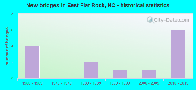
- New bridges - historical statistics
- 41960-1969
- 21980-1989
- 11990-1999
- 12000-2009
- 62010-2019


- Bridge Condition - Deck
- 57.1%Good
- 28.6%Satisfactory
- 14.3%Fair

- Bridge Condition - Superstructure
- 14.3%Very good
- 42.9%Good
- 42.9%Fair

- Bridge Condition - Substructure
- 71.4%Good
- 14.3%Satisfactory
- 14.3%Fair

- Bridge Condition - Channel
- 33.3%Very good
- 66.7%Good
Find on map >> Show street view
Structure Number: 890061, Location: 0.7 MI E JCT WITH US76 (Lat: 35.246894, Lng: -82.389094), Route carried "on" structure: State highway 1836, Year Built: 1999, Status: Open, Structure Length: 4.75m (15.58ft), Average Daily Traffic: 250 (year 2019), Truck Traffic: 6%, Average Future Daily Traffic: 500 (year 2040), Design Load: HS 20+Mod, Features Intersected: GREEN RIVER
Minimum Vertical Clearance: 30+ m (98+ ft), Kilometerpoint: 0.000, Lanes on structure: 2, Owner: State Highway Agency, Approaching Roadway Width: 5.1m (16.7ft), Material/Design: Steel, Design/Construction: Stringer/Multi-beam, Number Of Spans In Main Unit: 3, Length of Maximum Span: 15.5m (50.9ft), Curb-To-Curb Width: 6.5m (21.3ft), Out-to-Out Width: 7.5m (24.6ft)
Condition: Deck: Good, Superstructure: Good, Substructure: Good, Channel: Very good, Operating Rating: 60.7 metric tons, Method Used To Determine Operating Rating: Load Factor (LF), Inventory Rating: 36.2 metric tons, Method Used To Determine Inventory Rating: Load Factor (LF), Structural Evaluation: Better than present minimum criteria, Deck Geometry: Meets minimum limits, Waterway Adequacy: Equal to present desirable criteria, Approach Roadway Alignment: Equal to present minimum criteria, Designated Inspection Frequency: Every 24 months, Inspection Date: May 2021, Deck Structure Type: Concrete Cast-file-Place, Wearing Surface/Protective System: Wearing Surface: Monolithic Concrete, Deck Protection: Epoxy Coated Reinforcing
Find on map >> Show street view
Structure Number: 890111, Location: .4 MI.N.JCT.NC225 (Lat: 35.239525, Lng: -82.412078), Route carried "on" structure: US 25, Year Built: 1980, Status: Open, Structure Length: 5.66m (18.57ft), Average Daily Traffic: 9,750 (year 2019), Truck Traffic: 12%, Average Future Daily Traffic: 19,500 (year 2040), Design Load: HS 20+Mod, Features Intersected: SOUTHERN R.R.,SR1858
Minimum Vertical Clearance: 30+ m (98+ ft), Kilometerpoint: 1.737, Lanes on structure: 3, Lanes under structure: 2, Base Highway Network: Yes (Inventory Route: 2, Subroute: 25), Owner: State Highway Agency, Approaching Roadway Width: 13.7m (44.9ft), Skew: 11 degrees, Material/Design: Steel, Design/Construction: Stringer/Multi-beam, Number Of Spans In Main Unit: 4, Length of Maximum Span: 15.5m (50.9ft), Curb-To-Curb Width: 14.4m (47.2ft), Out-to-Out Width: 15.2m (49.9ft)
Condition: Deck: Satisfactory, Superstructure: Fair, Substructure: Good, Operating Rating: 87.0 metric tons, Method Used To Determine Operating Rating: Load Factor (LF), Inventory Rating: 51.7 metric tons, Method Used To Determine Inventory Rating: Load Factor (LF), Structural Evaluation: Somewhat better than minimum adequacy, Deck Geometry: Somewhat better than minimum adequacy, Underclear: Meets minimum limits, Approach Roadway Alignment: Equal to present desirable criteria, Designated Inspection Frequency: Every 24 months, Inspection Date: June 2021, Deck Structure Type: Concrete Cast-file-Place, Wearing Surface/Protective System: Wearing Surface: Monolithic Concrete, Deck Protection: Epoxy Coated Reinforcing
Find on map >> Show street view
Structure Number: 890127, Location: 1.8 MI. S. JCT. I-26 (Lat: 35.258733, Lng: -82.407631), Route carried "on" structure: US 25, Year Built: 2011, Status: Open, Structure Length: 6.76m (22.18ft), Average Daily Traffic: 9,000 (year 2017), Truck Traffic: 12%, Average Future Daily Traffic: 18,000 (year 2040), Design Load: HS 25 or greater, Features Intersected: US176
Minimum Vertical Clearance: 30+ m (98+ ft), Kilometerpoint: 2.164, Lanes on structure: 2, Lanes under structure: 4, Base Highway Network: Yes (Inventory Route: 2, Subroute: 25), Owner: State Highway Agency, Approaching Roadway Width: 11.5m (37.7ft), Skew: 14 degrees, Material/Design: Steel continuous, Design/Construction: Stringer/Multi-beam, Number Of Spans In Main Unit: 2, Length of Maximum Span: 34.1m (111.9ft), Curb-To-Curb Width: 11.5m (37.7ft), Out-to-Out Width: 12.5m (41.0ft)
Condition: Deck: Good, Superstructure: Good, Substructure: Good, Operating Rating: 89.8 metric tons, Method Used To Determine Operating Rating: Load Factor (LF), Inventory Rating: 68.9 metric tons, Method Used To Determine Inventory Rating: Load Factor (LF), Structural Evaluation: Better than present minimum criteria, Deck Geometry: Equal to present minimum criteria, Underclear: Meets minimum limits, Approach Roadway Alignment: Equal to present desirable criteria, Designated Inspection Frequency: Every 24 months, Inspection Date: May 2021, Deck Structure Type: Concrete Cast-file-Place, Wearing Surface/Protective System: Wearing Surface: Monolithic Concrete
Find on map >> Show street view
Structure Number: 890134, Location: 1 MI.S.JCT.SR1783 (Lat: 35.283058, Lng: -82.399722), Route carried "on" structure: US 25, Year Built: 1968, Status: Open, Structure Length: 7.98m (26.18ft), Average Daily Traffic: 8,750 (year 2018), Truck Traffic: 12%, Average Future Daily Traffic: 17,500 (year 2040), Design Load: HS 20+Mod, Features Intersected: I-26,US74
Minimum Vertical Clearance: 30+ m (98+ ft), Kilometerpoint: 0.000, Lanes on structure: 3, Lanes under structure: 4, Base Highway Network: Yes (Inventory Route: 2, Subroute: 25), Owner: State Highway Agency, Approaching Roadway Width: 14.6m (47.9ft), Skew: 3 degrees, Material/Design: Steel, Design/Construction: Stringer/Multi-beam, Number Of Spans In Main Unit: 4, Length of Maximum Span: 24.0m (78.7ft), Curb-To-Curb Width: 16.4m (53.8ft), Out-to-Out Width: 17.0m (55.8ft)
Condition: Deck: Fair, Superstructure: Fair, Substructure: Satisfactory, Operating Rating: 63.5 metric tons, Method Used To Determine Operating Rating: Load Factor (LF), Inventory Rating: 38.1 metric tons, Method Used To Determine Inventory Rating: Load Factor (LF), Structural Evaluation: Somewhat better than minimum adequacy, Deck Geometry: Better than present minimum criteria, Underclear: Somewhat better than minimum adequacy, Approach Roadway Alignment: Equal to present desirable criteria, Designated Inspection Frequency: Every 24 months, Inspection Date: March 2021, Deck Structure Type: Concrete Cast-file-Place, Wearing Surface/Protective System: Wearing Surface: Monolithic Concrete
Find on map >> Show street view
Structure Number: 890264, Location: .1 MI.E.JCT.SR1812 (Lat: 35.289344, Lng: -82.409983), Route carried "on" structure: State highway 1803, Year Built: 1961, Status: Posted for load, Structure Length: 1.85m (6.07ft), Average Daily Traffic: 2,600 (year 2014), Truck Traffic: 7%, Average Future Daily Traffic: 5,200 (year 2040), Features Intersected: BAT FORK CREEK
Minimum Vertical Clearance: 30+ m (98+ ft), Kilometerpoint: 0.000, Lanes on structure: 2, Owner: State Highway Agency, Approaching Roadway Width: 5.4m (17.7ft), Skew: 5 degrees, Material/Design: Steel, Design/Construction: Stringer/Multi-beam, Number Of Spans In Main Unit: 3, Length of Maximum Span: 6.0m (19.7ft), Curb-To-Curb Width: 6.0m (19.7ft), Out-to-Out Width: 6.4m (21.0ft)
Condition: Deck: Satisfactory, Superstructure: Fair, Substructure: Fair, Channel: Good, Operating Rating: 33.5 metric tons, Method Used To Determine Operating Rating: Load Factor (LF), Inventory Rating: 19.9 metric tons, Method Used To Determine Inventory Rating: Load Factor (LF), Structural Evaluation: Somewhat better than minimum adequacy, Deck Geometry: High priority of replacement, Waterway Adequacy: Better than present minimum criteria, Approach Roadway Alignment: Equal to present desirable criteria, Bridge Posting: Required (Relationship of Operating Rating to Maximum Legal Load: 10.0 - 19.9% below), Designated Inspection Frequency: Every 24 months, Inspection Date: June 2021, Deck Structure Type: Wood or Timber, Wearing Surface/Protective System: Wearing Surface: Bituminous
Find on map >> Show street view
Structure Number: 890375, Location: .6 MI.E.JCT.1836 (Lat: 35.235664, Lng: -82.395308), Route carried "on" structure: US 176, Year Built: 2001, Status: Open, Structure Length: 21.70m (71.19ft), Average Daily Traffic: 2,600 (year 2019), Truck Traffic: 7%, Average Future Daily Traffic: 5,200 (year 2040), Design Load: HS 20+Mod, Features Intersected: GREEN RIVER
Minimum Vertical Clearance: 30+ m (98+ ft), Kilometerpoint: 0.000, Lanes on structure: 2, Owner: State Highway Agency, Approaching Roadway Width: 9.1m (29.9ft), Material/Design: Steel continuous, Design/Construction: Stringer/Multi-beam, Number Of Spans In Main Unit: 4, Length of Maximum Span: 70.1m (230.0ft), Curb-To-Curb Width: 9.1m (29.9ft), Out-to-Out Width: 9.9m (32.5ft)
Condition: Deck: Good, Superstructure: Good, Substructure: Good, Channel: Good, Operating Rating: 41.7 metric tons, Method Used To Determine Operating Rating: Load Factor (LF), Inventory Rating: 24.4 metric tons, Method Used To Determine Inventory Rating: Load Factor (LF), Structural Evaluation: Equal to present minimum criteria, Deck Geometry: Meets minimum limits, Waterway Adequacy: Superior to present desirable criteria, Approach Roadway Alignment: Equal to present minimum criteria, Designated Inspection Frequency: Every 24 months, Inspection Date: July 2021, Deck Structure Type: Concrete Cast-file-Place, Wearing Surface/Protective System: Wearing Surface: Monolithic Concrete, Deck Protection: Epoxy Coated Reinforcing
Find on map >> Show street view
Structure Number: 890379, Location: 1.8 MI. S. JCT. I-26 (Lat: 35.258461, Lng: -82.407606), Route carried "on" structure: US 25, Year Built: 2011, Status: Open, Structure Length: 6.76m (22.18ft), Average Daily Traffic: 9,000 (year 2017), Truck Traffic: 12%, Average Future Daily Traffic: 18,000 (year 2040), Design Load: HS 25 or greater, Features Intersected: US176
Minimum Vertical Clearance: 30+ m (98+ ft), Kilometerpoint: 2.164, Lanes on structure: 2, Lanes under structure: 2, Base Highway Network: Yes (Inventory Route: 2, Subroute: 25), Owner: State Highway Agency, Approaching Roadway Width: 12.8m (42.0ft), Skew: 14 degrees, Material/Design: Steel continuous, Design/Construction: Stringer/Multi-beam, Number Of Spans In Main Unit: 2, Length of Maximum Span: 34.1m (111.9ft), Curb-To-Curb Width: 11.5m (37.7ft), Out-to-Out Width: 12.5m (41.0ft)
Condition: Deck: Good, Superstructure: Very good, Substructure: Good, Operating Rating: 89.8 metric tons, Method Used To Determine Operating Rating: Load Factor (LF), Inventory Rating: 68.0 metric tons, Method Used To Determine Inventory Rating: Load Factor (LF), Structural Evaluation: Better than present minimum criteria, Deck Geometry: High priority of corrective action, Underclear: Superior to present desirable criteria, Approach Roadway Alignment: Equal to present desirable criteria, Designated Inspection Frequency: Every 24 months, Inspection Date: May 2021, Deck Structure Type: Concrete Cast-file-Place, Wearing Surface/Protective System: Wearing Surface: Monolithic Concrete
Find on map >> Show street view
Structure Number: 890111, Location: .4 MI.N.JCT.NC225 (Lat: 35.239525, Lng: -82.412078), Route carried "under" structure: State highway 1858, Year Built: 1980, Structure Length: 0. m, Average Daily Traffic: 310 (year 2016), Truck Traffic: 7%, Features Intersected: US25 NBL
Minimum Vertical Clearance: 6.60m (21.65ft), Kilometerpoint: 0.000, Lanes on structure: 3, Lanes under structure: 2, Material/Design: Steel, Design/Construction: Stringer/Multi-beam, Length of Maximum Span: 15.5m (50.9ft)
Find on map >> Show street view
Structure Number: 890127, Location: 1.8 MI. S. JCT. I-26 (Lat: 35.258733, Lng: -82.407631), Route carried "under" structure: US 176, Year Built: 2011, Structure Length: 0. m, Average Daily Traffic: 6,500 (year 2013), Truck Traffic: 7%, Features Intersected: US25(25,I-26 CONN)
Minimum Vertical Clearance: 5.20m (17.06ft), Kilometerpoint: 0.000, Lanes on structure: 2, Lanes under structure: 2, Material/Design: Steel continuous, Design/Construction: Stringer/Multi-beam, Length of Maximum Span: 34.1m (111.9ft)
Find on map >> Show street view
Structure Number: 890127, Location: 1.8 MI. S. JCT. I-26 (Lat: 35.258733, Lng: -82.407631), Route carried "under" structure: US 176, Year Built: 2011, Structure Length: 0. m, Average Daily Traffic: 6,500 (year 2015), Truck Traffic: 7%, Features Intersected: US25(25,I-26 CONN)
Minimum Vertical Clearance: 5.65m (18.54ft), Kilometerpoint: 0.000, Lanes on structure: 2, Lanes under structure: 2, Material/Design: Steel continuous, Design/Construction: Stringer/Multi-beam, Length of Maximum Span: 34.1m (111.9ft)
Find on map >> Show street view
Structure Number: 890134, Location: 1 MI.S.JCT.SR1783 (Lat: 35.283058, Lng: -82.399722), Route carried "under" structure: Interstate 26, Year Built: 1968, Structure Length: 0. m, Average Daily Traffic: 31,750 (year 2019), Truck Traffic: 16%, Features Intersected: US25
Minimum Vertical Clearance: 5.10m (16.73ft), Kilometerpoint: 16.459, Lanes on structure: 3, Lanes under structure: 2, Material/Design: Steel, Design/Construction: Stringer/Multi-beam, Length of Maximum Span: 24.0m (78.7ft)
Find on map >> Show street view
Structure Number: 890134, Location: 1 MI.S.JCT.SR1783 (Lat: 35.283058, Lng: -82.399722), Route carried "under" structure: Interstate 26, Year Built: 1968, Structure Length: 0. m, Average Daily Traffic: 31,750 (year 2019), Truck Traffic: 16%, Features Intersected: US25
Minimum Vertical Clearance: 5.05m (16.57ft), Kilometerpoint: 16.459, Lanes on structure: 3, Lanes under structure: 2, Material/Design: Steel, Design/Construction: Stringer/Multi-beam, Length of Maximum Span: 24.0m (78.7ft)
Find on map >> Show street view
Structure Number: 890379, Location: 1.8 MI. S. JCT. I-26 (Lat: 35.258461, Lng: -82.407606), Route carried "under" structure: US 176, Year Built: 2011, Structure Length: 0. m, Average Daily Traffic: 6,500 (year 2015), Truck Traffic: 7%, Features Intersected: US25(25,I-26 CONN.
Minimum Vertical Clearance: 5.68m (18.64ft), Kilometerpoint: 0.000, Lanes on structure: 2, Lanes under structure: 1, Material/Design: Steel continuous, Design/Construction: Stringer/Multi-beam, Length of Maximum Span: 34.1m (111.9ft)
Find on map >> Show street view
Structure Number: 890379, Location: 1.8 MI. S. JCT. I-26 (Lat: 35.258461, Lng: -82.407606), Route carried "under" structure: US 176, Year Built: 2011, Structure Length: 0. m, Average Daily Traffic: 6,500 (year 2015), Truck Traffic: 7%, Features Intersected: US25(25,I-26 CONN.
Minimum Vertical Clearance: 6.03m (19.78ft), Kilometerpoint: 0.000, Lanes on structure: 2, Lanes under structure: 1, Material/Design: Steel continuous, Design/Construction: Stringer/Multi-beam, Length of Maximum Span: 34.1m (111.9ft)