Bridge Statistics for East Freedom, Pennsylvania (PA)
Condition, Traffic, Stress, Structural Evaluation, Project Costs
- National Bridge Inventory (NBI) Statistics
- 30Number of bridges
- 276ft / 84.3mTotal length
- $3,783,000Total costs
- 152,986Total average daily traffic
- 18,742Total average daily truck traffic
- National Bridge Inventory (NBI) Registered Bridges for East Freedom
- No street view available for this location
- New bridges - historical statistics
- 11910-1919
- 11920-1929
- 61950-1959
- 191980-1989
- 12000-2009
- 22010-2019
- Reconstructed bridges - Historical Statistics
- 11980-1989
- 21990-1999
- 52000-2009
- 32010-2019
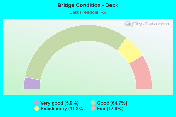
- Bridge Condition - Deck
- 5.9%Very good
- 64.7%Good
- 11.8%Satisfactory
- 17.6%Fair
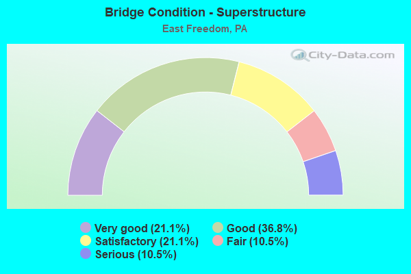
- Bridge Condition - Superstructure
- 21.1%Very good
- 36.8%Good
- 21.1%Satisfactory
- 10.5%Fair
- 10.5%Serious
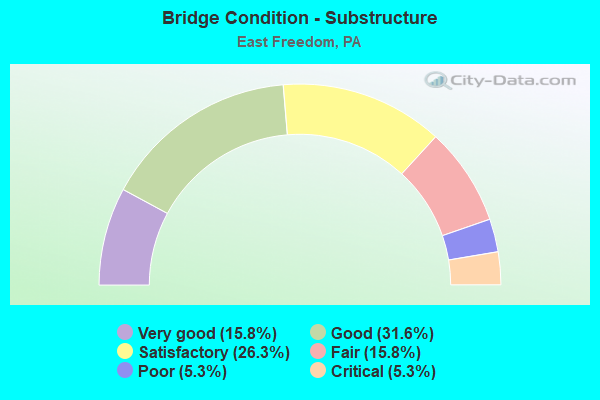
- Bridge Condition - Substructure
- 15.8%Very good
- 31.6%Good
- 26.3%Satisfactory
- 15.8%Fair
- 5.3%Poor
- 5.3%Critical
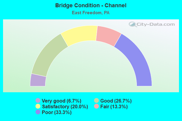
- Bridge Condition - Channel
- 6.7%Very good
- 26.7%Good
- 20.0%Satisfactory
- 13.3%Fair
- 33.3%Poor
Find on map >> Show street view
Structure Number: 555, Location: VILLAGE OF MCKEE (Lat: 40.360039, Lng: -78.417686), Route carried "on" structure: State highway 36, Year Built: 1951, Year Reconstructed: 1988, Status: Open, Structure Length: 3.81m (12.50ft), Average Daily Traffic: 17,747 (year 2021), Truck Traffic: 10%, Average Future Daily Traffic: 24,318 (year 2032), Design Load: HS 25 or greater, Features Intersected: HALTER CREEK
Minimum Vertical Clearance: 30+ m (98+ ft), Kilometerpoint: 10.995, Lanes on structure: 3, Owner: State Highway Agency, Approaching Roadway Width: 17.1m (56.1ft), Skew: 4 degrees, Material/Design: Steel, Design/Construction: Stringer/Multi-beam, Number Of Spans In Main Unit: 3, Length of Maximum Span: 12.5m (41.0ft), Curb or Sidewalk Widths: Left: 0.2m (0.7ft), Right: 0.2m (0.7ft), Curb-To-Curb Width: 17.1m (56.1ft), Out-to-Out Width: 17.8m (58.4ft)
Condition: Deck: Good, Superstructure: Good, Substructure: Good, Channel: Poor, Operating Rating: 85.3 metric tons, Method Used To Determine Operating Rating: Load Factor (LF), Inventory Rating: 50.8 metric tons, Method Used To Determine Inventory Rating: Load Factor (LF), Structural Evaluation: Better than present minimum criteria, Deck Geometry: Superior to present desirable criteria, Waterway Adequacy: Equal to present minimum criteria, Approach Roadway Alignment: Equal to present desirable criteria, Length Of Structure Improvement: 4.80m (15.75ft), Designated Inspection Frequency: Every 48 months, Inspection Date: July 2018, Deck Structure Type: Concrete Cast-file-Place, Wearing Surface/Protective System: Wearing Surface: Epoxy Overlay, Deck Protection: Epoxy Coated Reinforcing
Find on map >> Show street view
Structure Number: 5551, Location: VILLAGE OF MCKEE (Lat: 40.365697, Lng: -78.424897), Route carried "on" structure: State highway 36, Year Built: 1951, Year Reconstructed: 2015, Status: Open, Structure Length: 2.26m (7.41ft), Average Daily Traffic: 15,206 (year 2020), Truck Traffic: 6%, Average Future Daily Traffic: 23,500 (year 2032), Design Load: HS 25 or greater, Features Intersected: EVERETT RAILROAD
Minimum Vertical Clearance: 30+ m (98+ ft), Kilometerpoint: 11.919, Lanes on structure: 3, Owner: Railroad, Approaching Roadway Width: 18.6m (61.0ft), Material/Design: Steel continuous, Design/Construction: Stringer/Multi-beam, Number Of Spans In Main Unit: 3, Length of Maximum Span: 7.6m (24.9ft), Curb or Sidewalk Widths: Left: 0.2m (0.7ft), Right: 0.2m (0.7ft), Curb-To-Curb Width: 19.7m (64.6ft), Out-to-Out Width: 20.7m (67.9ft)
Condition: Deck: Satisfactory, Superstructure: Very good, Substructure: Good, Operating Rating: 75.3 metric tons, Method Used To Determine Operating Rating: Load Factor (LF), Inventory Rating: 45.4 metric tons, Method Used To Determine Inventory Rating: Load Factor (LF), Structural Evaluation: Better than present minimum criteria, Deck Geometry: Superior to present desirable criteria, Underclear: High priority of corrective action, Approach Roadway Alignment: Equal to present desirable criteria, Length Of Structure Improvement: 3.00m (9.84ft), Designated Inspection Frequency: Every 24 months, Inspection Date: Febuary 2021, Deck Structure Type: Concrete Cast-file-Place, Wearing Surface/Protective System: Wearing Surface: Epoxy Overlay, Deck Protection: Epoxy Coated Reinforcing
Find on map >> Show street view
Structure Number: 5568, Location: 1 MI.S.OF EAST FREEDOM (Lat: 40.338392, Lng: -78.429647), Route carried "on" structure: Interstate 99, Year Built: 1988, Year Reconstructed: 2011, Status: Open, Structure Length: 3.99m (13.09ft), Average Daily Traffic: 5,591 (year 2021), Truck Traffic: 21%, Average Future Daily Traffic: 7,171 (year 2032), Design Load: HS 25 or greater, Features Intersected: T349
Minimum Vertical Clearance: 30+ m (98+ ft), Kilometerpoint: 9.827, Lanes on structure: 2, Lanes under structure: 2, Base Highway Network: Yes, Owner: State Highway Agency, Approaching Roadway Width: 11.6m (38.1ft), Skew: 16 degrees, Material/Design: Prestressed concrete, Design/Construction: Stringer/Multi-beam, Number Of Spans In Main Unit: 1, Length of Maximum Span: 36.0m (118.1ft), Curb or Sidewalk Widths: Left: 0.2m (0.7ft), Right: 0.2m (0.7ft), Curb-To-Curb Width: 12.2m (40.0ft), Out-to-Out Width: 13.3m (43.6ft)
Condition: Deck: Good, Superstructure: Good, Substructure: Good, Inventory Rating: 49.9 metric tons, Method Used To Determine Inventory Rating: Load Factor (LF), Structural Evaluation: Better than present minimum criteria, Deck Geometry: Better than present minimum criteria, Underclear: Superior to present desirable criteria, Approach Roadway Alignment: Equal to present desirable criteria, Length Of Structure Improvement: 4.80m (15.75ft), Designated Inspection Frequency: Every 48 months, Inspection Date: June 2019, Deck Structure Type: Concrete Cast-file-Place, Wearing Surface/Protective System: Wearing Surface: Epoxy Overlay, Deck Protection: Epoxy Coated Reinforcing
Find on map >> Show street view
Structure Number: 5569, Location: .5 MI.S.OF EAST FREEDOM (Lat: 40.343094, Lng: -78.432022), Route carried "on" structure: Interstate 99, Year Built: 1986, Year Reconstructed: 2003, Status: Open, Structure Length: 23.20m (76.12ft), Average Daily Traffic: 5,591 (year 2021), Truck Traffic: 21%, Average Future Daily Traffic: 7,171 (year 2032), Design Load: HS 25 or greater, Features Intersected: SR 3013,C-101,RR,JUN RIV
Minimum Vertical Clearance: 30+ m (98+ ft), Kilometerpoint: 9.827, Lanes on structure: 2, Lanes under structure: 4, Base Highway Network: Yes, Owner: State Highway Agency, Approaching Roadway Width: 11.6m (38.1ft), Skew: 14 degrees, Material/Design: Steel continuous, Design/Construction: Stringer/Multi-beam, Number Of Spans In Main Unit: 5, Length of Maximum Span: 51.8m (169.9ft), Curb or Sidewalk Widths: Left: 0.2m (0.7ft), Right: 0.2m (0.7ft), Curb-To-Curb Width: 12.2m (40.0ft), Out-to-Out Width: 13.2m (43.3ft)
Condition: Deck: Good, Superstructure: Good, Substructure: Satisfactory, Channel: Very good, Operating Rating: 68.0 metric tons, Method Used To Determine Operating Rating: Load Factor (LF), Inventory Rating: 40.8 metric tons, Method Used To Determine Inventory Rating: Load Factor (LF), Structural Evaluation: Equal to present minimum criteria, Deck Geometry: Better than present minimum criteria, Underclear: Meets minimum limits, Waterway Adequacy: Superior to present desirable criteria, Approach Roadway Alignment: Equal to present desirable criteria, Length Of Structure Improvement: 23.70m (77.76ft), Designated Inspection Frequency: Every 24 months, Inspection Date: October 2020, Deck Structure Type: Concrete Cast-file-Place, Wearing Surface/Protective System: Wearing Surface: Monolithic Concrete, Deck Protection: Epoxy Coated Reinforcing
Find on map >> Show street view
Structure Number: 557, Location: 1 MI.S.OF EAST FREEDOM (Lat: 40.338539, Lng: -78.430006), Route carried "on" structure: Interstate 99, Year Built: 1988, Year Reconstructed: 2011, Status: Open, Structure Length: 4.21m (13.81ft), Average Daily Traffic: 5,576 (year 2021), Truck Traffic: 20%, Average Future Daily Traffic: 7,270 (year 2032), Design Load: HS 25 or greater, Features Intersected: T349
Minimum Vertical Clearance: 30+ m (98+ ft), Kilometerpoint: 9.804, Lanes on structure: 2, Lanes under structure: 2, Base Highway Network: Yes, Owner: State Highway Agency, Approaching Roadway Width: 11.6m (38.1ft), Skew: 16 degrees, Material/Design: Prestressed concrete, Design/Construction: Stringer/Multi-beam, Number Of Spans In Main Unit: 1, Length of Maximum Span: 37.8m (124.0ft), Curb or Sidewalk Widths: Left: 0.2m (0.7ft), Right: 0.2m (0.7ft), Curb-To-Curb Width: 12.2m (40.0ft), Out-to-Out Width: 13.3m (43.6ft)
Condition: Deck: Good, Superstructure: Good, Substructure: Fair, Inventory Rating: 48.1 metric tons, Method Used To Determine Inventory Rating: Load Factor (LF), Structural Evaluation: Somewhat better than minimum adequacy, Deck Geometry: Better than present minimum criteria, Underclear: Superior to present desirable criteria, Approach Roadway Alignment: Equal to present desirable criteria, Length Of Structure Improvement: 5.20m (17.06ft), Designated Inspection Frequency: Every 24 months, Inspection Date: June 2021, Deck Structure Type: Concrete Cast-file-Place, Wearing Surface/Protective System: Wearing Surface: Epoxy Overlay, Deck Protection: Epoxy Coated Reinforcing
Find on map >> Show street view
Structure Number: 5573, Location: EAST FREEDOM (Lat: 40.356825, Lng: -78.433892), Route carried "on" structure: Interstate 99, Year Built: 1987, Year Reconstructed: 2012, Status: Open, Structure Length: 6.31m (20.70ft), Average Daily Traffic: 5,591 (year 2021), Truck Traffic: 21%, Average Future Daily Traffic: 7,171 (year 2032), Design Load: HS 25 or greater, Features Intersected: PA 164 & SOUTH DRY RUN
Minimum Vertical Clearance: 30+ m (98+ ft), Kilometerpoint: 11.436, Lanes on structure: 2, Lanes under structure: 2, Base Highway Network: Yes, Owner: State Highway Agency, Approaching Roadway Width: 11.6m (38.1ft), Skew: 11 degrees, Material/Design: Prestressed concrete, Design/Construction: Stringer/Multi-beam, Number Of Spans In Main Unit: 2, Length of Maximum Span: 30.2m (99.1ft), Curb or Sidewalk Widths: Left: 0.2m (0.7ft), Right: 0.2m (0.7ft), Curb-To-Curb Width: 12.2m (40.0ft), Out-to-Out Width: 13.3m (43.6ft)
Condition: Deck: Good, Superstructure: Good, Substructure: Satisfactory, Channel: Satisfactory, Inventory Rating: 41.7 metric tons, Method Used To Determine Inventory Rating: Load Factor (LF), Structural Evaluation: Equal to present minimum criteria, Deck Geometry: Better than present minimum criteria, Underclear: Superior to present desirable criteria, Waterway Adequacy: Superior to present desirable criteria, Approach Roadway Alignment: Equal to present desirable criteria, Length Of Structure Improvement: 7.20m (23.62ft), Designated Inspection Frequency: Every 24 months, Inspection Date: June 2020, Deck Structure Type: Concrete Cast-file-Place, Wearing Surface/Protective System: Wearing Surface: Epoxy Overlay, Deck Protection: Epoxy Coated Reinforcing
Find on map >> Show street view
Structure Number: 5574, Location: EAST FREEDOM (Lat: 40.356603, Lng: -78.434106), Route carried "on" structure: Interstate 99, Year Built: 1987, Year Reconstructed: 2012, Status: Open, Structure Length: 6.31m (20.70ft), Average Daily Traffic: 5,576 (year 2021), Truck Traffic: 20%, Average Future Daily Traffic: 7,270 (year 2032), Design Load: HS 25 or greater, Features Intersected: PA 164 & SOUTH DRY RUN
Minimum Vertical Clearance: 30+ m (98+ ft), Kilometerpoint: 11.412, Lanes on structure: 2, Lanes under structure: 2, Base Highway Network: Yes, Owner: State Highway Agency, Approaching Roadway Width: 11.6m (38.1ft), Skew: 11 degrees, Material/Design: Prestressed concrete, Design/Construction: Stringer/Multi-beam, Number Of Spans In Main Unit: 2, Length of Maximum Span: 30.2m (99.1ft), Curb or Sidewalk Widths: Left: 0.2m (0.7ft), Right: 0.2m (0.7ft), Curb-To-Curb Width: 12.2m (40.0ft), Out-to-Out Width: 13.3m (43.6ft)
Condition: Deck: Good, Superstructure: Good, Substructure: Satisfactory, Channel: Satisfactory, Inventory Rating: 41.7 metric tons, Method Used To Determine Inventory Rating: Load Factor (LF), Structural Evaluation: Equal to present minimum criteria, Deck Geometry: Better than present minimum criteria, Underclear: Superior to present desirable criteria, Waterway Adequacy: Superior to present desirable criteria, Approach Roadway Alignment: Equal to present desirable criteria, Length Of Structure Improvement: 7.20m (23.62ft), Designated Inspection Frequency: Every 24 months, Inspection Date: June 2020, Deck Structure Type: Concrete Cast-file-Place, Wearing Surface/Protective System: Wearing Surface: Epoxy Overlay, Deck Protection: Epoxy Coated Reinforcing
Find on map >> Show street view
Structure Number: 5576, Location: 1 MI.S.OF NEWRY (Lat: 40.380108, Lng: -78.434300), Route carried "on" structure: Interstate 99, Year Built: 1987, Year Reconstructed: 2013, Status: Open, Structure Length: 6.68m (21.92ft), Average Daily Traffic: 10,325 (year 2021), Truck Traffic: 15%, Average Future Daily Traffic: 12,358 (year 2032), Design Load: HS 25 or greater, Features Intersected: SR 3013
Minimum Vertical Clearance: 30+ m (98+ ft), Kilometerpoint: 14.627, Lanes on structure: 2, Lanes under structure: 2, Base Highway Network: Yes, Owner: State Highway Agency, Approaching Roadway Width: 12.2m (40.0ft), Skew: 14 degrees, Material/Design: Prestressed concrete, Design/Construction: Box Beam or Girders - Multiple, Number Of Spans In Main Unit: 1, Number Of Approach Spans: 2, Length of Maximum Span: 28.0m (91.9ft), Curb or Sidewalk Widths: Left: 0.2m (0.7ft), Right: 0.2m (0.7ft), Curb-To-Curb Width: 12.8m (42.0ft), Out-to-Out Width: 13.9m (45.6ft)
Condition: Deck: Good, Superstructure: Satisfactory, Substructure: Satisfactory, Operating Rating: 81.6 metric tons, Method Used To Determine Operating Rating: Load Factor (LF), Inventory Rating: 39.9 metric tons, Method Used To Determine Inventory Rating: Load Factor (LF), Structural Evaluation: Equal to present minimum criteria, Deck Geometry: Equal to present desirable criteria, Underclear: Equal to present minimum criteria, Approach Roadway Alignment: Equal to present desirable criteria, Length Of Structure Improvement: 7.70m (25.26ft), Designated Inspection Frequency: Every 48 months, Inspection Date: July 2020, Deck Structure Type: Concrete Cast-file-Place, Wearing Surface/Protective System: Wearing Surface: Epoxy Overlay, Deck Protection: Epoxy Coated Reinforcing
Find on map >> Show street view
Structure Number: 5615, Location: VILLAGE OF EAST FREEDOM (Lat: 40.357803, Lng: -78.430217), Route carried "on" structure: State highway 164, Year Built: 1957, Year Reconstructed: 2001, Status: Open, Structure Length: 1.40m (4.59ft), Average Daily Traffic: 8,312 (year 2021), Truck Traffic: 7%, Average Future Daily Traffic: 11,681 (year 2032), Design Load: HS 20, Features Intersected: SOUTH DRY RUN
Minimum Vertical Clearance: 30+ m (98+ ft), Kilometerpoint: 15.424, Lanes on structure: 2, Owner: State Highway Agency, Approaching Roadway Width: 10.4m (34.1ft), Skew: 3 degrees, Material/Design: Concrete, Design/Construction: Tee Beam, Number Of Spans In Main Unit: 2, Length of Maximum Span: 6.4m (21.0ft), Curb-To-Curb Width: 11.6m (38.1ft), Out-to-Out Width: 12.7m (41.7ft)
Condition: Deck: Satisfactory, Superstructure: Satisfactory, Substructure: Good, Channel: Fair, Operating Rating: 59.0 metric tons, Method Used To Determine Operating Rating: Load Factor (LF), Inventory Rating: 35.4 metric tons, Method Used To Determine Inventory Rating: Load Factor (LF), Structural Evaluation: Equal to present minimum criteria, Deck Geometry: Somewhat better than minimum adequacy, Waterway Adequacy: Equal to present minimum criteria, Approach Roadway Alignment: Equal to present desirable criteria, Length Of Structure Improvement: 2.00m (6.56ft), Designated Inspection Frequency: Every 24 months, Inspection Date: Febuary 2020, Deck Structure Type: Concrete Cast-file-Place, Wearing Surface/Protective System: Wearing Surface: Bituminous, Membrane: Preformed Fabric
Find on map >> Show street view
Structure Number: 5617, Location: EAST FREEDOM (Lat: 40.367208, Lng: -78.426981), Route carried "on" structure: State highway 164, Year Built: 1987, Year Reconstructed: 2015, Status: Open, Structure Length: 7.77m (25.49ft), Average Daily Traffic: 17,157 (year 2021), Truck Traffic: 11%, Average Future Daily Traffic: 24,654 (year 2032), Design Load: HS 25 or greater, Features Intersected: FRANKSTWN BR JUNIATA
Minimum Vertical Clearance: 30+ m (98+ ft), Kilometerpoint: 16.929, Lanes on structure: 5, Owner: State Highway Agency, Approaching Roadway Width: 24.4m (80.1ft), Skew: 23 degrees, Material/Design: Prestressed concrete, Design/Construction: Stringer/Multi-beam, Number Of Spans In Main Unit: 2, Length of Maximum Span: 37.5m (123.0ft), Curb or Sidewalk Widths: Left: 0.2m (0.7ft), Right: 0.2m (0.7ft), Curb-To-Curb Width: 26.8m (87.9ft), Out-to-Out Width: 27.9m (91.5ft)
Condition: Deck: Good, Superstructure: Good, Substructure: Good, Channel: Good, Operating Rating: 72.6 metric tons, Method Used To Determine Operating Rating: Load Factor (LF), Inventory Rating: 26.3 metric tons, Method Used To Determine Inventory Rating: Load Factor (LF), Structural Evaluation: Equal to present minimum criteria, Deck Geometry: Superior to present desirable criteria, Waterway Adequacy: Superior to present desirable criteria, Approach Roadway Alignment: Equal to present desirable criteria, Length Of Structure Improvement: 8.70m (28.54ft), Designated Inspection Frequency: Every 24 months, Inspection Date: January 2021, Deck Structure Type: Concrete Cast-file-Place, Wearing Surface/Protective System: Wearing Surface: Latex Concrete, Deck Protection: Epoxy Coated Reinforcing
Find on map >> Show street view
Structure Number: 5731, Location: EAST FREEDOM (Lat: 40.356272, Lng: -78.427878), Route carried "on" structure: State highway , Year Built: 1925, Year Reconstructed: 2010, Status: Open, Structure Length: 2.71m (8.89ft), Average Daily Traffic: 1,478 (year 2021), Truck Traffic: 3%, Average Future Daily Traffic: 2,280 (year 2032), Features Intersected: FRANKSTOWN BR JUNIATA R, Facility Carried by Structure: SR 2010
Minimum Vertical Clearance: 30+ m (98+ ft), Kilometerpoint: 0.000, Lanes on structure: 2, Owner: State Highway Agency, Approaching Roadway Width: 8.5m (27.9ft), Material/Design: Concrete, Design/Construction: Arch - Deck, Number Of Spans In Main Unit: 1, Length of Maximum Span: 27.1m (88.9ft), Curb or Sidewalk Widths: Left: 0.2m (0.7ft), Right: 0.2m (0.7ft), Curb-To-Curb Width: 6.5m (21.3ft), Out-to-Out Width: 7.6m (24.9ft)
Condition: Superstructure: Satisfactory, Substructure: Satisfactory, Channel: Poor, Operating Rating: 60.8 metric tons, Method Used To Determine Operating Rating: Field evaluation and documented engineering judgment, Inventory Rating: 36.3 metric tons, Method Used To Determine Inventory Rating: Field evaluation and documented engineering judgment, Structural Evaluation: Equal to present minimum criteria, Deck Geometry: High priority of replacement, Waterway Adequacy: Equal to present desirable criteria, Approach Roadway Alignment: Better than present minimum criteria, Length Of Structure Improvement: 3.50m (11.48ft), Designated Inspection Frequency: Every 24 months, Inspection Date: March 2021, Bridge Improvement Cost: $82,000, Roadway Improvement Cost: $264,000, Total Project Cost: $1,109,000, Deck Structure Type: Concrete Cast-file-Place, Wearing Surface/Protective System: Wearing Surface: Bituminous, Membrane: Preformed Fabric, Deck Protection: Epoxy Coated Reinforcing
Find on map >> Show street view
Structure Number: 5919, Location: 2 MI.W.OF EAST FREEDOM (Lat: 40.353889, Lng: -78.468003), Route carried "on" structure: City street , Year Built: 1957, Status: Open, Structure Length: 0.98m (3.22ft), Average Daily Traffic: 253 (year 2021), Truck Traffic: 1%, Average Future Daily Traffic: 316 (year 2041), Design Load: HS 20, Features Intersected: TRIB. OF SOUTH DRY RUN, Facility Carried by Structure: T352,Butler Hlw Rd
Minimum Vertical Clearance: 30+ m (98+ ft), Kilometerpoint: 0.000, Lanes on structure: 2, Owner: County Highway Agency, Approaching Roadway Width: 5.2m (17.1ft), Skew: 2 degrees, Material/Design: Prestressed concrete, Design/Construction: Box Beam or Girders - Multiple, Number Of Spans In Main Unit: 1, Length of Maximum Span: 8.8m (28.9ft), Curb or Sidewalk Widths: Left: 0.2m (0.7ft), Right: 0.2m (0.7ft), Curb-To-Curb Width: 6.0m (19.7ft), Out-to-Out Width: 6.4m (21.0ft)
Condition: Deck: Fair, Superstructure: Fair, Substructure: Poor, Channel: Poor, Operating Rating: 56.2 metric tons, Method Used To Determine Operating Rating: Load Factor (LF), Inventory Rating: 31.8 metric tons, Method Used To Determine Inventory Rating: Load Factor (LF), Structural Evaluation: Meets minimum limits, Deck Geometry: High priority of corrective action, Waterway Adequacy: Better than present minimum criteria, Approach Roadway Alignment: Equal to present desirable criteria, Length Of Structure Improvement: 1.30m (4.27ft), Designated Inspection Frequency: Every 24 months, Inspection Date: August 2021, Bridge Improvement Cost: $48,000, Roadway Improvement Cost: $264,000, Total Project Cost: $651,000, Deck Structure Type: Other, Wearing Surface/Protective System: Wearing Surface: Bituminous
Find on map >> Show street view
Structure Number: 592, Location: 2 MI.W.OF EAST FREEDOM (Lat: 40.354664, Lng: -78.466481), Route carried "on" structure: City street , Year Built: 1957, Status: Open, Structure Length: 1.25m (4.10ft), Average Daily Traffic: 253 (year 2021), Truck Traffic: 1%, Average Future Daily Traffic: 354 (year 2041), Design Load: HS 20, Features Intersected: SOUTH DRY RUN, Facility Carried by Structure: T352,Butler Hlw Rd
Minimum Vertical Clearance: 30+ m (98+ ft), Kilometerpoint: 0.000, Lanes on structure: 2, Owner: County Highway Agency, Approaching Roadway Width: 5.2m (17.1ft), Skew: 2 degrees, Material/Design: Prestressed concrete, Design/Construction: Box Beam or Girders - Multiple, Number Of Spans In Main Unit: 1, Length of Maximum Span: 11.0m (36.1ft), Curb or Sidewalk Widths: Left: 0.2m (0.7ft), Right: 0.2m (0.7ft), Curb-To-Curb Width: 6.0m (19.7ft), Out-to-Out Width: 6.5m (21.3ft)
Condition: Deck: Fair, Superstructure: Fair, Substructure: Fair, Channel: Fair, Operating Rating: 44.5 metric tons, Method Used To Determine Operating Rating: Load Factor (LF), Inventory Rating: 20.9 metric tons, Method Used To Determine Inventory Rating: Load Factor (LF), Structural Evaluation: Somewhat better than minimum adequacy, Deck Geometry: High priority of corrective action, Waterway Adequacy: Better than present minimum criteria, Approach Roadway Alignment: Equal to present desirable criteria, Length Of Structure Improvement: 1.60m (5.25ft), Designated Inspection Frequency: Every 24 months, Inspection Date: August 2021, Bridge Improvement Cost: $54,000, Roadway Improvement Cost: $264,000, Total Project Cost: $723,000, Deck Structure Type: Other, Wearing Surface/Protective System: Wearing Surface: Bituminous
Find on map >> Show street view
Structure Number: 5921, Location: JUGTOWN (Lat: 40.337636, Lng: -78.434453), Route carried "on" structure: City street , Year Built: 1954, Status: Posted for load, Structure Length: 3.66m (12.01ft), Average Daily Traffic: 451 (year 2021), Average Future Daily Traffic: 188 (year 2041), Design Load: HS 20, Features Intersected: FRTOWN.BR.JUNIATA RIVER, Facility Carried by Structure: T-349 Mountain Rd
Minimum Vertical Clearance: 30+ m (98+ ft), Kilometerpoint: 0.000, Lanes on structure: 1, Owner: County Highway Agency, Approaching Roadway Width: 3.7m (12.1ft), Material/Design: Steel, Design/Construction: Girder and Floorbeam System, Number Of Spans In Main Unit: 2, Length of Maximum Span: 17.4m (57.1ft), Curb or Sidewalk Widths: Left: 1.0m (3.3ft), Right: 0.2m (0.7ft), Curb-To-Curb Width: 3.1m (10.2ft), Out-to-Out Width: 3.1m (10.2ft)
Condition: Deck: Fair, Superstructure: Serious, Substructure: Fair, Channel: Poor, Operating Rating: 29.9 metric tons, Method Used To Determine Operating Rating: Load Factor (LF), Inventory Rating: 17.2 metric tons, Method Used To Determine Inventory Rating: Load Factor (LF), Structural Evaluation: High priority of corrective action, Deck Geometry: High priority of replacement, Waterway Adequacy: Better than present minimum criteria, Approach Roadway Alignment: Equal to present desirable criteria, Bridge Posting: Required (Relationship of Operating Rating to Maximum Legal Load: 30.0 - 39.9% below), Length Of Structure Improvement: 4.60m (15.09ft), Designated Inspection Frequency: Every 24 months, Critical Feature Inspection Frequency: Every 6 months, Other Special Inspection Frequency: Every 6 months, Inspection Date: August 2020, Critical Feature Inspection Date: August 2021, Other Special Inspection Date: August 2021, Bridge Improvement Cost: $41,000, Roadway Improvement Cost: $120,000, Total Project Cost: $550,000, Deck Structure Type: Open Grating
Find on map >> Show street view
Structure Number: 5922, Location: VILLAGE OF EAST FREEDOM (Lat: 40.356800, Lng: -78.434597), Route carried "on" structure: City street , Year Built: 1987, Status: Open, Structure Length: 1.83m (6.00ft), Average Daily Traffic: 103 (year 2021), Truck Traffic: 1%, Average Future Daily Traffic: 131 (year 2041), Design Load: HS 25 or greater, Features Intersected: SOUTH DRY RUN, Facility Carried by Structure: T367,CREAM HOL.RD
Minimum Vertical Clearance: 30+ m (98+ ft), Kilometerpoint: 0.000, Lanes on structure: 2, Owner: Town or Township Highway Agency, Approaching Roadway Width: 9.8m (32.2ft), Material/Design: Prestressed concrete, Design/Construction: Box Beam or Girders - Single/Spread, Number Of Spans In Main Unit: 1, Length of Maximum Span: 18.0m (59.1ft), Curb or Sidewalk Widths: Left: 0.2m (0.7ft), Right: 0.2m (0.7ft), Curb-To-Curb Width: 9.8m (32.2ft), Out-to-Out Width: 10.8m (35.4ft)
Condition: Deck: Good, Superstructure: Satisfactory, Substructure: Good, Channel: Satisfactory, Operating Rating: 64.4 metric tons, Method Used To Determine Operating Rating: Load Factor (LF), Inventory Rating: 38.1 metric tons, Method Used To Determine Inventory Rating: Load Factor (LF), Structural Evaluation: Equal to present minimum criteria, Deck Geometry: Better than present minimum criteria, Waterway Adequacy: Superior to present desirable criteria, Approach Roadway Alignment: Better than present minimum criteria, Length Of Structure Improvement: 2.50m (8.20ft), Designated Inspection Frequency: Every 24 months, Inspection Date: July 2021, Deck Structure Type: Concrete Cast-file-Place, Wearing Surface/Protective System: Wearing Surface: Monolithic Concrete, Deck Protection: Epoxy Coated Reinforcing
Find on map >> Show street view
Structure Number: 5924, Location: EAST FREEDOM (Lat: 40.357319, Lng: -78.428497), Route carried "on" structure: County highway , Year Built: 1913, Status: Posted for load, Structure Length: 1.22m (4.00ft), Average Daily Traffic: 1,634 (year 2021), Truck Traffic: 1%, Average Future Daily Traffic: 2,043 (year 2041), Features Intersected: SOUTH DRY RUN, Facility Carried by Structure: CO RD 101,Bedfrd S
Minimum Vertical Clearance: 30+ m (98+ ft), Kilometerpoint: 0.000, Lanes on structure: 2, Owner: County Highway Agency, Approaching Roadway Width: 7.0m (23.0ft), Material/Design: Concrete, Design/Construction: Arch - Deck, Number Of Spans In Main Unit: 1, Length of Maximum Span: 12.2m (40.0ft), Curb or Sidewalk Widths: Left: 1.6m (5.2ft), Right: 1.3m (4.3ft), Curb-To-Curb Width: 7.9m (25.9ft), Out-to-Out Width: 11.2m (36.7ft)
Condition: Superstructure: Serious, Substructure: Critical, Channel: Poor, Operating Rating: 45.4 metric tons, Method Used To Determine Operating Rating: Field evaluation and documented engineering judgment, Inventory Rating: 27.2 metric tons, Method Used To Determine Inventory Rating: Field evaluation and documented engineering judgment, Structural Evaluation: High priority of replacement, Deck Geometry: Meets minimum limits, Waterway Adequacy: Better than present minimum criteria, Approach Roadway Alignment: Equal to present desirable criteria, Length Of Structure Improvement: 1.50m (4.92ft), Designated Inspection Frequency: Every 24 months, Other Special Inspection Frequency: Every 6 months, Inspection Date: October 2021, Other Special Inspection Date: October 2021, Bridge Improvement Cost: $56,000, Roadway Improvement Cost: $264,000, Total Project Cost: $750,000
Find on map >> Show street view
Structure Number: 41558, Location: 1 MI.W.OF EAST FREEDOM (Lat: 40.354142, Lng: -78.447461), Route carried "on" structure: State highway 164, Year Built: 2001, Status: Open, Structure Length: 1.04m (3.41ft), Average Daily Traffic: 1,204 (year 2020), Truck Traffic: 13%, Average Future Daily Traffic: 2,118 (year 2032), Design Load: HL 93, Features Intersected: SOUTH DRY RUN
Minimum Vertical Clearance: 30+ m (98+ ft), Kilometerpoint: 13.840, Lanes on structure: 2, Owner: State Highway Agency, Approaching Roadway Width: 11.6m (38.1ft), Material/Design: Prestressed concrete, Design/Construction: Slab, Number Of Spans In Main Unit: 1, Length of Maximum Span: 10.1m (33.1ft), Curb or Sidewalk Widths: Left: 0.2m (0.7ft), Right: 0.2m (0.7ft), Curb-To-Curb Width: 11.4m (37.4ft), Out-to-Out Width: 12.3m (40.4ft)
Condition: Deck: Good, Superstructure: Very good, Substructure: Very good, Channel: Good, Operating Rating: 85.3 metric tons, Method Used To Determine Operating Rating: Load and Resistance Factor (LRFR), Inventory Rating: 46.3 metric tons, Method Used To Determine Inventory Rating: Load and Resistance Factor (LRFR), Structural Evaluation: Equal to present desirable criteria, Deck Geometry: Equal to present minimum criteria, Waterway Adequacy: Superior to present desirable criteria, Approach Roadway Alignment: Equal to present desirable criteria, Length Of Structure Improvement: 1.70m (5.58ft), Designated Inspection Frequency: Every 48 months, Inspection Date: Febuary 2020, Deck Structure Type: Concrete Cast-file-Place, Wearing Surface/Protective System: Wearing Surface: Monolithic Concrete, Deck Protection: Epoxy Coated Reinforcing
Find on map >> Show street view
Structure Number: 4608, Location: 1.5 MILE NORTH OF MCKEE (Lat: 40.373472, Lng: -78.423153), Route carried "on" structure: State highway 36, Year Built: 2010, Status: Open, Structure Length: 1.25m (4.10ft), Average Daily Traffic: 6,269 (year 2022), Truck Traffic: 4%, Average Future Daily Traffic: 7,293 (year 2032), Design Load: HL 93, Features Intersected: HALTER CREEK
Minimum Vertical Clearance: 30+ m (98+ ft), Kilometerpoint: 12.905, Lanes on structure: 2, Owner: State Highway Agency, Approaching Roadway Width: 8.5m (27.9ft), Material/Design: Prestressed concrete, Design/Construction: Box Beam or Girders - Single/Spread, Number Of Spans In Main Unit: 1, Length of Maximum Span: 12.2m (40.0ft), Curb-To-Curb Width: 9.8m (32.2ft), Out-to-Out Width: 10.7m (35.1ft)
Condition: Deck: Very good, Superstructure: Very good, Substructure: Very good, Channel: Good, Operating Rating: 85.3 metric tons, Method Used To Determine Operating Rating: Load Factor (LF), Inventory Rating: 50.8 metric tons, Method Used To Determine Inventory Rating: Load Factor (LF), Structural Evaluation: Equal to present desirable criteria, Deck Geometry: Meets minimum limits, Waterway Adequacy: Equal to present desirable criteria, Approach Roadway Alignment: Equal to present desirable criteria, Designated Inspection Frequency: Every 48 months, Inspection Date: March 2019, Deck Structure Type: Concrete Cast-file-Place, Wearing Surface/Protective System: Wearing Surface: Monolithic Concrete, Deck Protection: Epoxy Coated Reinforcing
Find on map >> Show street view
Structure Number: 46159, Location: 1.2 MILE SOUTH OF CATFISH (Lat: 40.377114, Lng: -78.419789), Route carried "on" structure: State highway 36, Year Built: 2010, Status: Open, Structure Length: 4.39m (14.40ft), Average Daily Traffic: 6,269 (year 2022), Truck Traffic: 4%, Average Future Daily Traffic: 7,293 (year 2032), Design Load: HL 93, Features Intersected: FRANKSTOWN BR JUNIATA R
Minimum Vertical Clearance: 30+ m (98+ ft), Kilometerpoint: 13.388, Lanes on structure: 2, Base Highway Network: Yes, Owner: State Highway Agency, Approaching Roadway Width: 9.4m (30.8ft), Skew: 1 degrees, Material/Design: Prestressed concrete, Design/Construction: Stringer/Multi-beam, Number Of Spans In Main Unit: 2, Length of Maximum Span: 21.3m (69.9ft), Curb or Sidewalk Widths: Left: 0.2m (0.7ft), Right: 0.2m (0.7ft), Curb-To-Curb Width: 9.8m (32.2ft), Out-to-Out Width: 10.8m (35.4ft)
Condition: Deck: Good, Superstructure: Very good, Substructure: Very good, Channel: Good, Operating Rating: 67.1 metric tons, Method Used To Determine Operating Rating: Load and Resistance Factor (LRFR), Inventory Rating: 44.5 metric tons, Method Used To Determine Inventory Rating: Load and Resistance Factor (LRFR), Structural Evaluation: Equal to present desirable criteria, Deck Geometry: Meets minimum limits, Waterway Adequacy: Equal to present desirable criteria, Approach Roadway Alignment: Equal to present desirable criteria, Length Of Structure Improvement: 4.40m (14.44ft), Designated Inspection Frequency: Every 24 months, Inspection Date: Febuary 2021, Deck Structure Type: Concrete Cast-file-Place, Wearing Surface/Protective System: Wearing Surface: Monolithic Concrete, Deck Protection: Galvanized Reinforcing
Find on map >> Show street view
Structure Number: 5568, Location: 1 MI.S.OF EAST FREEDOM (Lat: 40.338392, Lng: -78.429647), Route carried "under" structure: City street , Year Built: 1988, Structure Length: 0. m, Average Daily Traffic: 25 (year 1993), Features Intersected: T349, Facility Carried by Structure: I-99 / US 220 NBL
Minimum Vertical Clearance: 6.93m (22.74ft), Kilometerpoint: 0.000, Lanes on structure: 2, Lanes under structure: 2, Material/Design: Prestressed concrete, Design/Construction: Stringer/Multi-beam, Length of Maximum Span: 36.0m (118.1ft)
Find on map >> Show street view
Structure Number: 5569, Location: .5 MI.S.OF EAST FREEDOM (Lat: 40.343094, Lng: -78.432022), Route carried "under" structure: US 220B, Year Built: 1986, Structure Length: 0. m, Average Daily Traffic: 5,688 (year 2020), Truck Traffic: 10%, Features Intersected: SR 3013,C-101,RR,JUN RIV, Facility Carried by Structure: I-99 / US 220 NBL
Minimum Vertical Clearance: 6.55m (21.49ft), Kilometerpoint: 9.833, Lanes on structure: 2, Lanes under structure: 2, Material/Design: Steel continuous, Design/Construction: Stringer/Multi-beam, Length of Maximum Span: 51.8m (169.9ft)
Find on map >> Show street view
Structure Number: 5569, Location: .5 MI.S.OF EAST FREEDOM (Lat: 40.343094, Lng: -78.432022), Route carried "under" structure: County highway , Year Built: 1986, Structure Length: 0. m, Average Daily Traffic: 50 (year 2004), Features Intersected: SR 3013,C-101,RR,JUN RIV, Facility Carried by Structure: I-99 / US 220 NBL
Minimum Vertical Clearance: 8.26m (27.10ft), Kilometerpoint: 0.000, Lanes on structure: 2, Lanes under structure: 2, Material/Design: Steel continuous, Design/Construction: Stringer/Multi-beam, Length of Maximum Span: 51.8m (169.9ft)
Find on map >> Show street view
Structure Number: 557, Location: 1 MI.S.OF EAST FREEDOM (Lat: 40.338539, Lng: -78.430006), Route carried "under" structure: City street , Year Built: 1988, Structure Length: 0. m, Average Daily Traffic: 25 (year 1993), Features Intersected: T349, Facility Carried by Structure: I-99 / US 220 SBL
Minimum Vertical Clearance: 6.68m (21.92ft), Kilometerpoint: 0.000, Lanes on structure: 2, Lanes under structure: 2, Material/Design: Prestressed concrete, Design/Construction: Stringer/Multi-beam, Length of Maximum Span: 37.8m (124.0ft)
Find on map >> Show street view
Structure Number: 5571, Location: 0.5MI.S.OF EAST FREEDOM (Lat: 40.343517, Lng: -78.432469), Route carried "under" structure: County highway , Year Built: 1986, Structure Length: 0. m, Average Daily Traffic: 50 (year 2004), Features Intersected: SR 3013,C-101,RR,JUN.RIV, Facility Carried by Structure: I-99 / US 220 SBL
Minimum Vertical Clearance: 7.89m (25.89ft), Kilometerpoint: 0.000, Lanes on structure: 2, Lanes under structure: 2, Material/Design: Steel continuous, Design/Construction: Stringer/Multi-beam, Length of Maximum Span: 51.8m (169.9ft)
Find on map >> Show street view
Structure Number: 5571, Location: 0.5MI.S.OF EAST FREEDOM (Lat: 40.343517, Lng: -78.432469), Route carried "under" structure: US 220B, Year Built: 1986, Structure Length: 0. m, Average Daily Traffic: 5,688 (year 2020), Truck Traffic: 10%, Features Intersected: SR 3013,C-101,RR,JUN.RIV, Facility Carried by Structure: I-99 / US 220 SBL
Minimum Vertical Clearance: 6.00m (19.69ft), Kilometerpoint: 9.833, Lanes on structure: 2, Lanes under structure: 2, Material/Design: Steel continuous, Design/Construction: Stringer/Multi-beam, Length of Maximum Span: 51.8m (169.9ft)
Find on map >> Show street view
Structure Number: 5573, Location: EAST FREEDOM (Lat: 40.356825, Lng: -78.433892), Route carried "under" structure: State highway 164, Year Built: 1987, Structure Length: 0. m, Average Daily Traffic: 1,204 (year 2020), Truck Traffic: 13%, Features Intersected: PA 164 & SOUTH DRY RUN, Facility Carried by Structure: I-99 / US 220 NBL
Minimum Vertical Clearance: 7.03m (23.06ft), Kilometerpoint: 14.536, Lanes on structure: 2, Lanes under structure: 2, Material/Design: Prestressed concrete, Design/Construction: Stringer/Multi-beam, Length of Maximum Span: 30.2m (99.1ft)
Find on map >> Show street view
Structure Number: 5574, Location: EAST FREEDOM (Lat: 40.356603, Lng: -78.434106), Route carried "under" structure: State highway 164, Year Built: 1987, Structure Length: 0. m, Average Daily Traffic: 1,204 (year 2020), Truck Traffic: 13%, Features Intersected: PA 164 & SOUTH DRY RUN, Facility Carried by Structure: I-99 / US 220 SBL
Minimum Vertical Clearance: 6.86m (22.51ft), Kilometerpoint: 14.536, Lanes on structure: 2, Lanes under structure: 2, Material/Design: Prestressed concrete, Design/Construction: Stringer/Multi-beam, Length of Maximum Span: 30.2m (99.1ft)
Find on map >> Show street view
Structure Number: 5576, Location: 1 MI.S.OF NEWRY (Lat: 40.380108, Lng: -78.434300), Route carried "under" structure: US 220B, Year Built: 1987, Structure Length: 0. m, Average Daily Traffic: 8,565 (year 2020), Truck Traffic: 17%, Features Intersected: SR 3013, Facility Carried by Structure: I-99 / US 220 NBL
Minimum Vertical Clearance: 5.97m (19.59ft), Kilometerpoint: 13.266, Lanes on structure: 2, Lanes under structure: 2, Material/Design: Prestressed concrete, Design/Construction: Box Beam or Girders - Multiple, Length of Maximum Span: 28.0m (91.9ft)
Find on map >> Show street view
Structure Number: 6026, Location: 2 MI.S.OF NEWRY (Lat: 40.369572, Lng: -78.436158), Route carried "under" structure: Interstate 99, Year Built: 1987, Structure Length: 0. m, Average Daily Traffic: 10,325 (year 2021), Truck Traffic: 15%, Features Intersected: I-99 / US 220, Facility Carried by Structure: SR 8025 @ EXIT 23
Minimum Vertical Clearance: 4.72m (15.49ft), Kilometerpoint: 13.045, Lanes on structure: 2, Lanes under structure: 2, Material/Design: Prestressed concrete, Design/Construction: Box Beam or Girders - Single/Spread, Length of Maximum Span: 33.2m (108.9ft)
Find on map >> Show street view
Structure Number: 6026, Location: 2 MI.S.OF NEWRY (Lat: 40.369572, Lng: -78.436158), Route carried "under" structure: Interstate 99, Year Built: 1987, Structure Length: 0. m, Average Daily Traffic: 5,576 (year 2021), Truck Traffic: 20%, Features Intersected: I-99 / US 220, Facility Carried by Structure: SR 8025 @ EXIT 23
Minimum Vertical Clearance: 5.39m (17.68ft), Kilometerpoint: 13.021, Lanes on structure: 2, Lanes under structure: 3, Material/Design: Prestressed concrete, Design/Construction: Box Beam or Girders - Single/Spread, Length of Maximum Span: 33.2m (108.9ft)