Bridge Statistics for East Freehold, New Jersey (NJ)
Condition, Traffic, Stress, Structural Evaluation, Project Costs
- National Bridge Inventory (NBI) Statistics
- 29Number of bridges
- 180ft / 54.6mTotal length
- $6,392,000Total costs
- 536,102Total average daily traffic
- 26,128Total average daily truck traffic
- National Bridge Inventory (NBI) Registered Bridges for East Freehold
- No street view available for this location
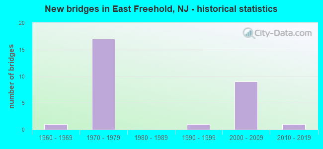
- New bridges - historical statistics
- 11960-1969
- 171970-1979
- 11990-1999
- 92000-2009
- 12010-2019


- Bridge Condition - Deck
- 7.1%Very good
- 42.9%Good
- 42.9%Satisfactory
- 7.1%Fair

- Bridge Condition - Superstructure
- 28.6%Very good
- 64.3%Good
- 7.1%Fair

- Bridge Condition - Substructure
- 21.4%Very good
- 64.3%Good
- 14.3%Satisfactory

- Bridge Condition - Channel
- 9.1%Excellent
- 9.1%Good
- 54.5%Satisfactory
- 27.3%Fair

- Bridge Condition - Culverts
- 83.3%Good
- 16.7%Satisfactory
Find on map >> Show street view
Structure Number: 13000A4, Location: 1.5 MILES WEST OF NJ 34 (Lat: 40.319661, Lng: -74.214011), Route carried "on" structure: Other road , Year Built: 2018, Status: Open, Structure Length: 1.65m (5.41ft), Average Daily Traffic: 2,588 (year 2021), Truck Traffic: 3%, Average Future Daily Traffic: 3,158 (year 2041), Design Load: HL 93, Features Intersected: BIG BROOK, Facility Carried by Structure: HILLSDALE ROAD
Minimum Vertical Clearance: 30+ m (98+ ft), Kilometerpoint: 0.000, Lanes on structure: 2, Owner: County Highway Agency, Approaching Roadway Width: 7.6m (24.9ft), Material/Design: Prestressed concrete, Design/Construction: Slab, Number Of Spans In Main Unit: 1, Length of Maximum Span: 14.9m (48.9ft), Curb or Sidewalk Widths: Left: 0.1m (0.3ft), Right: 0.1m (0.3ft), Curb-To-Curb Width: 7.3m (24.0ft), Out-to-Out Width: 8.6m (28.2ft)
Condition: Deck: Very good, Superstructure: Very good, Substructure: Very good, Channel: Satisfactory, Operating Rating: 53.5 metric tons, Method Used To Determine Operating Rating: Field evaluation and documented engineering judgment, Inventory Rating: 41.7 metric tons, Method Used To Determine Inventory Rating: Field evaluation and documented engineering judgment, Structural Evaluation: Equal to present desirable criteria, Deck Geometry: High priority of replacement, Waterway Adequacy: Better than present minimum criteria, Approach Roadway Alignment: Equal to present desirable criteria, Length Of Structure Improvement: 1.65m (5.41ft), Designated Inspection Frequency: Every 24 months, Inspection Date: May 2021, Total Project Cost: $1,000 ( Estimate for 2021), Deck Structure Type: Concrete Cast-file-Place, Wearing Surface/Protective System: Wearing Surface: Monolithic Concrete
Find on map >> Show street view
Structure Number: 13000A7, Location: 0.29 miles N. of CR 537 (Lat: 40.285689, Lng: -74.198150), Route carried "on" structure: Other road , Year Built: 2000, Status: Open, Structure Length: 0.76m (2.49ft), Average Daily Traffic: 1,115 (year 2021), Truck Traffic: 3%, Average Future Daily Traffic: 1,138 (year 2041), Design Load: HS 20+Mod, Features Intersected: YELLOW BROOK, Facility Carried by Structure: BUCKS MILL ROAD
Minimum Vertical Clearance: 30+ m (98+ ft), Kilometerpoint: 0.000, Lanes on structure: 2, Owner: County Highway Agency, Approaching Roadway Width: 7.9m (25.9ft), Material/Design: Prestressed concrete, Design/Construction: Slab, Number Of Spans In Main Unit: 1, Length of Maximum Span: 7.3m (24.0ft), Curb-To-Curb Width: 7.9m (25.9ft), Out-to-Out Width: 9.4m (30.8ft)
Condition: Deck: Good, Superstructure: Good, Substructure: Very good, Channel: Good, Inventory Rating: 71.7 metric tons, Method Used To Determine Inventory Rating: Load Factor (LF), Structural Evaluation: Better than present minimum criteria, Deck Geometry: Meets minimum limits, Waterway Adequacy: Equal to present desirable criteria, Approach Roadway Alignment: Equal to present desirable criteria, Designated Inspection Frequency: Every 24 months, Inspection Date: May 2021, Deck Structure Type: Concrete Cast-file-Place, Wearing Surface/Protective System: Wearing Surface: Monolithic Concrete, Deck Protection: Galvanized Reinforcing
Find on map >> Show street view
Structure Number: 13000F8, Location: 1 MILE EAST OF NJ 18 (Lat: 40.274361, Lng: -74.225519), Route carried "on" structure: County highway 537, Year Built: 1975, Status: Open, Structure Length: 0.67m (2.20ft), Average Daily Traffic: 9,682 (year 2021), Truck Traffic: 4%, Average Future Daily Traffic: 11,814 (year 2041), Features Intersected: YELLOW BROOK
Minimum Vertical Clearance: 30+ m (98+ ft), Kilometerpoint: 88.514, Lanes on structure: 3, Base Highway Network: Yes, Owner: County Highway Agency, Approaching Roadway Width: 15.2m (49.9ft), Skew: 1 degrees, Material/Design: Concrete, Design/Construction: Culvert, Number Of Spans In Main Unit: 1, Length of Maximum Span: 6.7m (22.0ft), Curb or Sidewalk Widths: Left: 2.7m (8.9ft), Right: 4.8m (15.7ft), Curb-To-Curb Width: 15.1m (49.5ft), Out-to-Out Width: 28.0m (91.9ft)
Condition: Channel: Satisfactory, Culverts: Satisfactory, Operating Rating: 63.5 metric tons, Method Used To Determine Operating Rating: Load Factor (LF), Inventory Rating: 38.1 metric tons, Method Used To Determine Inventory Rating: Load Factor (LF), Structural Evaluation: Equal to present minimum criteria, Deck Geometry: Equal to present minimum criteria, Waterway Adequacy: Equal to present minimum criteria, Approach Roadway Alignment: Equal to present desirable criteria, Designated Inspection Frequency: Every 24 months, Underwater Inspection Frequency: Every 24 months, Inspection Date: May 2021, Underwater Inspection Date: May 2021
Find on map >> Show street view
Structure Number: 1300A17, Location: 0.23 MILE SOUTH OF CR 537 (Lat: 40.280689, Lng: -74.187600), Route carried "on" structure: Other road , Year Built: 1996, Status: Open, Structure Length: 0.67m (2.20ft), Average Daily Traffic: 3,877 (year 2021), Truck Traffic: 3%, Average Future Daily Traffic: 4,731 (year 2041), Design Load: HS 20+Mod, Features Intersected: MINE BROOK, Facility Carried by Structure: HOMINY HILL ROAD
Minimum Vertical Clearance: 30+ m (98+ ft), Kilometerpoint: 0.000, Lanes on structure: 2, Owner: County Highway Agency, Approaching Roadway Width: 11.0m (36.1ft), Skew: 2 degrees, Material/Design: Prestressed concrete, Design/Construction: Box Beam or Girders - Multiple, Number Of Spans In Main Unit: 1, Length of Maximum Span: 5.8m (19.0ft), Curb or Sidewalk Widths: Left: 1.5m (4.9ft), Right: 1.5m (4.9ft), Curb-To-Curb Width: 11.0m (36.1ft), Out-to-Out Width: 14.6m (47.9ft)
Condition: Deck: Satisfactory, Superstructure: Good, Substructure: Good, Channel: Satisfactory, Structural Evaluation: Better than present minimum criteria, Deck Geometry: Somewhat better than minimum adequacy, Waterway Adequacy: Equal to present desirable criteria, Approach Roadway Alignment: Better than present minimum criteria, Designated Inspection Frequency: Every 24 months, Inspection Date: April 2021, Deck Structure Type: Concrete Precast Panels, Wearing Surface/Protective System: Wearing Surface: Monolithic Concrete
Find on map >> Show street view
Structure Number: 1300F67, Location: 0.12 miles N. of CR 537 (Lat: 40.270981, Lng: -74.245181), Route carried "on" structure: County highway 55, Year Built: 2001, Status: Open, Structure Length: 1.95m (6.40ft), Average Daily Traffic: 23,789 (year 2021), Truck Traffic: 4%, Average Future Daily Traffic: 29,028 (year 2041), Design Load: HS 25 or greater, Features Intersected: RAMP A, Facility Carried by Structure: KOZLOSKI ROAD EXT.
Minimum Vertical Clearance: 30+ m (98+ ft), Kilometerpoint: 4.426, Lanes on structure: 4, Lanes under structure: 2, Owner: County Highway Agency, Approaching Roadway Width: 24.4m (80.1ft), Skew: 10 degrees, Material/Design: Prestressed concrete, Design/Construction: Stringer/Multi-beam, Number Of Spans In Main Unit: 1, Length of Maximum Span: 19.2m (63.0ft), Curb or Sidewalk Widths: Left: 1.8m (5.9ft), Right: 1.8m (5.9ft), Curb-To-Curb Width: 24.4m (80.1ft), Out-to-Out Width: 29.3m (96.1ft)
Condition: Deck: Good, Superstructure: Very good, Substructure: Good, Operating Rating: 68.0 metric tons, Method Used To Determine Operating Rating: Load Factor (LF), Inventory Rating: 40.8 metric tons, Method Used To Determine Inventory Rating: Load Factor (LF), Structural Evaluation: Better than present minimum criteria, Deck Geometry: Superior to present desirable criteria, Underclear: Equal to present minimum criteria, Approach Roadway Alignment: Equal to present desirable criteria, Designated Inspection Frequency: Every 24 months, Inspection Date: May 2021, Deck Structure Type: Concrete Cast-file-Place, Wearing Surface/Protective System: Wearing Surface: Monolithic Concrete, Deck Protection: Galvanized Reinforcing
Find on map >> Show street view
Structure Number: 1305161, Location: 2.7 MI E. OF NJ RT. 9 (Lat: 40.233331, Lng: -74.219981), Route carried "on" structure: State highway 33, Year Built: 2004, Status: Open, Structure Length: 3.44m (11.29ft), Average Daily Traffic: 22,661 (year 2020), Truck Traffic: 7%, Average Future Daily Traffic: 27,651 (year 2040), Design Load: HL 93, Features Intersected: 33 BUSINESS EB
Minimum Vertical Clearance: 30.45m (99.90ft), Kilometerpoint: 49.407, Lanes on structure: 2, Lanes under structure: 1, Base Highway Network: Yes, Owner: State Highway Agency, Approaching Roadway Width: 16.2m (53.1ft), Skew: 12 degrees, Material/Design: Steel, Design/Construction: Stringer/Multi-beam, Number Of Spans In Main Unit: 1, Length of Maximum Span: 33.5m (109.9ft), Curb-To-Curb Width: 16.2m (53.1ft), Out-to-Out Width: 18.3m (60.0ft)
Condition: Deck: Good, Superstructure: Good, Substructure: Good, Operating Rating: 71.0 metric tons, Method Used To Determine Operating Rating: Load and Resistance Factor Rating (LRFR) rating reported by rating factor(RF) method using HL-93 loadings, Inventory Rating: 54.4 metric tons, Method Used To Determine Inventory Rating: Load and Resistance Factor Rating (LRFR) rating reported by rating factor(RF) method using HL-93 loadings, Structural Evaluation: Better than present minimum criteria, Deck Geometry: Superior to present desirable criteria, Underclear: Equal to present minimum criteria, Approach Roadway Alignment: Equal to present desirable criteria, Designated Inspection Frequency: Every 24 months, Inspection Date: April 2020, Deck Structure Type: Concrete Cast-file-Place, Wearing Surface/Protective System: Wearing Surface: Monolithic Concrete, Deck Protection: Epoxy Coated Reinforcing
Find on map >> Show street view
Structure Number: 1305164, Location: 0.16 Miles E of Howell Rd (Lat: 40.234139, Lng: -74.229750), Route carried "on" structure: State highway 33, Year Built: 2002, Status: Open, Structure Length: 2.93m (9.61ft), Average Daily Traffic: 18,265 (year 2021), Truck Traffic: 5%, Average Future Daily Traffic: 21,918 (year 2041), Design Load: HL 93, Features Intersected: LONG BROOK CREEK
Minimum Vertical Clearance: 30+ m (98+ ft), Kilometerpoint: 48.618, Lanes on structure: 2, Base Highway Network: Yes, Owner: State Highway Agency, Approaching Roadway Width: 26.5m (86.9ft), Skew: 34 degrees, Material/Design: Prestressed concrete, Design/Construction: Stringer/Multi-beam, Number Of Spans In Main Unit: 1, Length of Maximum Span: 27.1m (88.9ft), Curb-To-Curb Width: 26.4m (86.6ft), Out-to-Out Width: 28.3m (92.8ft)
Condition: Deck: Good, Superstructure: Very good, Substructure: Very good, Channel: Excellent, Operating Rating: 66.7 metric tons, Method Used To Determine Operating Rating: Load and Resistance Factor Rating (LRFR) rating reported by rating factor(RF) method using HL-93 loadings, Inventory Rating: 53.1 metric tons, Method Used To Determine Inventory Rating: Load and Resistance Factor Rating (LRFR) rating reported by rating factor(RF) method using HL-93 loadings, Structural Evaluation: Equal to present desirable criteria, Deck Geometry: Superior to present desirable criteria, Waterway Adequacy: Equal to present desirable criteria, Approach Roadway Alignment: Equal to present desirable criteria, Designated Inspection Frequency: Every 24 months, Inspection Date: May 2021, Deck Structure Type: Concrete Cast-file-Place, Wearing Surface/Protective System: Deck Protection: Epoxy Coated Reinforcing
Find on map >> Show street view
Structure Number: 1305165, Location: 3 MI. E. OF JCT RT 9 (Lat: 40.234439, Lng: -74.221519), Route carried "on" structure: State highway 33, Year Built: 2003, Status: Open, Structure Length: 3.32m (10.89ft), Average Daily Traffic: 20,370 (year 2021), Truck Traffic: 7%, Average Future Daily Traffic: 24,270 (year 2041), Design Load: HL 93, Features Intersected: FAIRFIELD ROAD
Minimum Vertical Clearance: 30+ m (98+ ft), Kilometerpoint: 49.310, Lanes on structure: 2, Lanes under structure: 3, Base Highway Network: Yes, Owner: State Highway Agency, Approaching Roadway Width: 16.5m (54.1ft), Skew: 10 degrees, Material/Design: Prestressed concrete, Design/Construction: Stringer/Multi-beam, Number Of Spans In Main Unit: 1, Length of Maximum Span: 32.0m (105.0ft), Curb-To-Curb Width: 16.5m (54.1ft), Out-to-Out Width: 28.5m (93.5ft)
Condition: Deck: Good, Superstructure: Very good, Substructure: Good, Operating Rating: 78.1 metric tons, Method Used To Determine Operating Rating: Load and Resistance Factor Rating (LRFR) rating reported by rating factor(RF) method using HL-93 loadings, Inventory Rating: 60.3 metric tons, Method Used To Determine Inventory Rating: Load and Resistance Factor Rating (LRFR) rating reported by rating factor(RF) method using HL-93 loadings, Structural Evaluation: Better than present minimum criteria, Deck Geometry: Superior to present desirable criteria, Underclear: Superior to present desirable criteria, Approach Roadway Alignment: Equal to present desirable criteria, Designated Inspection Frequency: Every 24 months, Inspection Date: June 2021, Deck Structure Type: Concrete Cast-file-Place, Wearing Surface/Protective System: Wearing Surface: Monolithic Concrete, Deck Protection: Epoxy Coated Reinforcing
Find on map >> Show street view
Structure Number: 130ML55, Location: 2 MI EAST OF ROUTE 18 (Lat: 40.319519, Lng: -74.223050), Route carried "on" structure: City street , Year Built: 1969, Status: Open, Structure Length: 2.90m (9.51ft), Average Daily Traffic: 2,740 (year 2021), Truck Traffic: 3%, Average Future Daily Traffic: 3,290 (year 2041), Design Load: HS 20, Features Intersected: BIG BROOK, Facility Carried by Structure: BOUNDARY ROAD
Minimum Vertical Clearance: 30+ m (98+ ft), Kilometerpoint: 1.979, Lanes on structure: 2, Owner: County Highway Agency, Approaching Roadway Width: 9.1m (29.9ft), Skew: 2 degrees, Material/Design: Prestressed concrete, Design/Construction: Box Beam or Girders - Multiple, Number Of Spans In Main Unit: 3, Length of Maximum Span: 14.0m (45.9ft), Curb or Sidewalk Widths: Left: 2.0m (6.6ft), Right: 0.5m (1.6ft), Curb-To-Curb Width: 9.2m (30.2ft), Out-to-Out Width: 12.3m (40.4ft)
Condition: Deck: Fair, Superstructure: Fair, Substructure: Satisfactory, Channel: Fair, Operating Rating: 39.0 metric tons, Method Used To Determine Operating Rating: Load Factor (LF), Inventory Rating: 23.6 metric tons, Method Used To Determine Inventory Rating: Load Factor (LF), Structural Evaluation: Somewhat better than minimum adequacy, Deck Geometry: Meets minimum limits, Waterway Adequacy: Equal to present desirable criteria, Approach Roadway Alignment: Better than present minimum criteria, Length Of Structure Improvement: 2.90m (9.51ft), Designated Inspection Frequency: Every 24 months, Inspection Date: Febuary 2021, Bridge Improvement Cost: $1,847,000, Roadway Improvement Cost: $277,000, Total Project Cost: $3,170,000 ( Estimate for 2019), Deck Structure Type: Concrete Cast-file-Place, Wearing Surface/Protective System: Wearing Surface: Monolithic Concrete
Find on map >> Show street view
Structure Number: 1324151, Location: 1.5 MI N OF NJ 34 JCT (Lat: 40.264581, Lng: -74.193619), Route carried "on" structure: State highway 18, Year Built: 1973, Status: Open, Structure Length: 0.70m (2.30ft), Average Daily Traffic: 52,094 (year 2020), Truck Traffic: 5%, Average Future Daily Traffic: 63,564 (year 2040), Design Load: HS 20, Features Intersected: MINE BROOK
Minimum Vertical Clearance: 30+ m (98+ ft), Kilometerpoint: 33.024, Lanes on structure: 4, Base Highway Network: Yes, Owner: State Highway Agency, Approaching Roadway Width: 40.2m (131.9ft), Skew: 22 degrees, Material/Design: Concrete, Design/Construction: Culvert, Number Of Spans In Main Unit: 2, Length of Maximum Span: 3.4m (11.2ft)
Condition: Channel: Satisfactory, Culverts: Good, Operating Rating: 49.9 metric tons, Method Used To Determine Operating Rating: Load Factor (LF), Inventory Rating: 29.9 metric tons, Method Used To Determine Inventory Rating: Load Factor (LF), Structural Evaluation: Better than present minimum criteria, Waterway Adequacy: Equal to present minimum criteria, Approach Roadway Alignment: Equal to present desirable criteria, Designated Inspection Frequency: Every 24 months, Inspection Date: August 2020
Find on map >> Show street view
Structure Number: 1324152, Location: 0.65 MI S OF CO 537 JCT (Lat: 40.268531, Lng: -74.212761), Route carried "on" structure: City street , Year Built: 1973, Status: Open, Structure Length: 6.04m (19.82ft), Average Daily Traffic: 836 (year 2021), Truck Traffic: 3%, Average Future Daily Traffic: 1,200 (year 2041), Design Load: HS 20, Features Intersected: NJ RT 18, Facility Carried by Structure: FIVE POINTS ROAD
Minimum Vertical Clearance: 30+ m (98+ ft), Kilometerpoint: 1.143, Lanes on structure: 2, Lanes under structure: 4, Owner: State Highway Agency, Approaching Roadway Width: 12.2m (40.0ft), Skew: 1 degrees, Material/Design: Steel, Design/Construction: Stringer/Multi-beam, Number Of Spans In Main Unit: 2, Length of Maximum Span: 29.6m (97.1ft), Curb or Sidewalk Widths: Left: 0.5m (1.6ft), Right: 1.8m (5.9ft), Curb-To-Curb Width: 9.2m (30.2ft), Out-to-Out Width: 12.7m (41.7ft)
Condition: Deck: Satisfactory, Superstructure: Good, Substructure: Good, Operating Rating: 68.9 metric tons, Method Used To Determine Operating Rating: Load Factor (LF), Inventory Rating: 40.8 metric tons, Method Used To Determine Inventory Rating: Load Factor (LF), Structural Evaluation: Better than present minimum criteria, Deck Geometry: Equal to present minimum criteria, Underclear: High priority of corrective action, Approach Roadway Alignment: Equal to present minimum criteria, Length Of Structure Improvement: 6.04m (19.82ft), Designated Inspection Frequency: Every 24 months, Inspection Date: August 2021, Roadway Improvement Cost: $128,000, Total Project Cost: $150,000 ( Estimate for 2021), Deck Structure Type: Concrete Cast-file-Place, Wearing Surface/Protective System: Wearing Surface: Monolithic Concrete
Find on map >> Show street view
Structure Number: 1324153, Location: 0.35 MI SO OF CR 537 JCT (Lat: 40.274281, Lng: -74.219819), Route carried "on" structure: State highway 18, Year Built: 1972, Status: Open, Structure Length: 0.94m (3.08ft), Average Daily Traffic: 45,879 (year 2020), Truck Traffic: 5%, Average Future Daily Traffic: 55,055 (year 2040), Design Load: HS 20, Features Intersected: YELLOW BROOK
Minimum Vertical Clearance: 30+ m (98+ ft), Kilometerpoint: 35.341, Lanes on structure: 6, Base Highway Network: Yes, Owner: State Highway Agency, Approaching Roadway Width: 24.1m (79.1ft), Skew: 20 degrees, Material/Design: Concrete, Design/Construction: Culvert, Number Of Spans In Main Unit: 2, Length of Maximum Span: 4.6m (15.1ft)
Condition: Channel: Fair, Culverts: Good, Operating Rating: 89.8 metric tons, Method Used To Determine Operating Rating: Load Factor (LF), Inventory Rating: 89.8 metric tons, Method Used To Determine Inventory Rating: Load Factor (LF), Structural Evaluation: Better than present minimum criteria, Waterway Adequacy: Superior to present desirable criteria, Approach Roadway Alignment: Equal to present desirable criteria, Designated Inspection Frequency: Every 24 months, Inspection Date: June 2020
Find on map >> Show street view
Structure Number: 1324154, Location: 0.13mi E. of 18-537 int. (Lat: 40.276039, Lng: -74.218681), Route carried "on" structure: County highway 537, Year Built: 1972, Status: Open, Structure Length: 1.25m (4.10ft), Average Daily Traffic: 17,905 (year 2021), Truck Traffic: 4%, Average Future Daily Traffic: 21,466 (year 2041), Design Load: HS 20, Features Intersected: YELLOW BROOK
Minimum Vertical Clearance: 30+ m (98+ ft), Kilometerpoint: 89.109, Lanes on structure: 7, Base Highway Network: Yes, Owner: State Highway Agency, Approaching Roadway Width: 22.9m (75.1ft), Skew: 4 degrees, Material/Design: Concrete, Design/Construction: Culvert, Number Of Spans In Main Unit: 2, Length of Maximum Span: 5.8m (19.0ft), Curb or Sidewalk Widths: Left: 0.0m, Right: 2.4m (7.9ft)
Condition: Channel: Satisfactory, Culverts: Good, Operating Rating: 55.3 metric tons, Method Used To Determine Operating Rating: Load Factor (LF), Inventory Rating: 32.7 metric tons, Method Used To Determine Inventory Rating: Load Factor (LF), Structural Evaluation: Better than present minimum criteria, Waterway Adequacy: Equal to present minimum criteria, Approach Roadway Alignment: Equal to present desirable criteria, Designated Inspection Frequency: Every 24 months, Inspection Date: March 2021
Find on map >> Show street view
Structure Number: 1324155, Location: 1000' E of NJ 18/537 JCT. (Lat: 40.276839, Lng: -74.218131), Route carried "on" structure: City street , Year Built: 1972, Status: Open, Structure Length: 1.01m (3.31ft), Average Daily Traffic: 1,805 (year 2020), Truck Traffic: 1%, Average Future Daily Traffic: 2,202 (year 2040), Features Intersected: Yellow Brook., Facility Carried by Structure: School Road East.
Minimum Vertical Clearance: 30+ m (98+ ft), Kilometerpoint: 0.064, Lanes on structure: 2, Owner: State Highway Agency, Approaching Roadway Width: 7.3m (24.0ft), Skew: 1 degrees, Material/Design: Concrete, Design/Construction: Culvert, Number Of Spans In Main Unit: 2, Length of Maximum Span: 4.6m (15.1ft)
Condition: Channel: Fair, Culverts: Good, Operating Rating: 61.7 metric tons, Method Used To Determine Operating Rating: Load Factor (LF), Inventory Rating: 36.3 metric tons, Method Used To Determine Inventory Rating: Load Factor (LF), Structural Evaluation: Better than present minimum criteria, Waterway Adequacy: Equal to present minimum criteria, Approach Roadway Alignment: Equal to present minimum criteria, Designated Inspection Frequency: Every 24 months, Inspection Date: December 2020
Find on map >> Show street view
Structure Number: 1324156, Location: 3.3 MI NORTH OF JCT 18-34 (Lat: 40.275500, Lng: -74.221750), Route carried "on" structure: State highway 18, Year Built: 1973, Status: Open, Structure Length: 3.47m (11.38ft), Average Daily Traffic: 26,048 (year 2020), Truck Traffic: 5%, Average Future Daily Traffic: 31,783 (year 2040), Design Load: HS 20, Features Intersected: RT 537
Minimum Vertical Clearance: 30+ m (98+ ft), Kilometerpoint: 35.904, Lanes on structure: 3, Lanes under structure: 6, Base Highway Network: Yes, Owner: State Highway Agency, Approaching Roadway Width: 12.8m (42.0ft), Skew: 1 degrees, Material/Design: Steel, Design/Construction: Stringer/Multi-beam, Number Of Spans In Main Unit: 1, Length of Maximum Span: 33.5m (109.9ft), Curb or Sidewalk Widths: Left: 1.1m (3.6ft), Right: 0.2m (0.7ft), Curb-To-Curb Width: 12.9m (42.3ft), Out-to-Out Width: 15.5m (50.9ft)
Condition: Deck: Satisfactory, Superstructure: Good, Substructure: Satisfactory, Operating Rating: 60.8 metric tons, Method Used To Determine Operating Rating: Load Factor (LF), Inventory Rating: 36.3 metric tons, Method Used To Determine Inventory Rating: Load Factor (LF), Structural Evaluation: Equal to present minimum criteria, Deck Geometry: High priority of replacement, Underclear: Equal to present minimum criteria, Approach Roadway Alignment: Equal to present desirable criteria, Length Of Structure Improvement: 3.47m (11.38ft), Designated Inspection Frequency: Every 24 months, Inspection Date: August 2020, Bridge Improvement Cost: $68,000, Roadway Improvement Cost: $24,000, Total Project Cost: $169,000 ( Estimate for 2020), Deck Structure Type: Concrete Cast-file-Place, Wearing Surface/Protective System: Wearing Surface: Monolithic Concrete
Find on map >> Show street view
Structure Number: 1324157, Location: 2.9 MI S OF RT 79 JCT (Lat: 40.275419, Lng: -74.220961), Route carried "on" structure: State highway 18, Year Built: 1973, Status: Open, Structure Length: 3.47m (11.38ft), Average Daily Traffic: 23,985 (year 2021), Truck Traffic: 5%, Average Future Daily Traffic: 28,782 (year 2041), Design Load: HS 20, Features Intersected: CR 537
Minimum Vertical Clearance: 30+ m (98+ ft), Kilometerpoint: 35.904, Lanes on structure: 3, Lanes under structure: 6, Base Highway Network: Yes, Owner: State Highway Agency, Approaching Roadway Width: 12.8m (42.0ft), Skew: 1 degrees, Material/Design: Steel, Design/Construction: Stringer/Multi-beam, Number Of Spans In Main Unit: 1, Length of Maximum Span: 33.5m (109.9ft), Curb or Sidewalk Widths: Left: 0.2m (0.7ft), Right: 1.1m (3.6ft), Curb-To-Curb Width: 12.8m (42.0ft), Out-to-Out Width: 15.5m (50.9ft)
Condition: Deck: Satisfactory, Superstructure: Good, Substructure: Good, Inventory Rating: 62.6 metric tons, Method Used To Determine Inventory Rating: Load Factor (LF), Structural Evaluation: Better than present minimum criteria, Deck Geometry: High priority of replacement, Underclear: Equal to present minimum criteria, Approach Roadway Alignment: Equal to present desirable criteria, Length Of Structure Improvement: 3.47m (11.38ft), Designated Inspection Frequency: Every 24 months, Inspection Date: March 2021, Bridge Improvement Cost: $23,000, Roadway Improvement Cost: $21,000, Total Project Cost: $61,000 ( Estimate for 2021), Deck Structure Type: Concrete Cast-file-Place, Wearing Surface/Protective System: Wearing Surface: Monolithic Concrete
Find on map >> Show street view
Structure Number: 1324158, Location: 0.99 MI SO OF RT 79 (Lat: 40.299789, Lng: -74.237981), Route carried "on" structure: County highway 46, Year Built: 1973, Status: Open, Structure Length: 6.04m (19.82ft), Average Daily Traffic: 950 (year 2021), Truck Traffic: 3%, Average Future Daily Traffic: 1,415 (year 2041), Design Load: HS 20, Features Intersected: NJ 18, Facility Carried by Structure: DUTCH LANE ROAD
Minimum Vertical Clearance: 30+ m (98+ ft), Kilometerpoint: 4.748, Lanes on structure: 2, Lanes under structure: 4, Owner: State Highway Agency, Approaching Roadway Width: 13.4m (44.0ft), Skew: 1 degrees, Material/Design: Steel, Design/Construction: Stringer/Multi-beam, Number Of Spans In Main Unit: 2, Length of Maximum Span: 30.2m (99.1ft), Curb or Sidewalk Widths: Left: 1.8m (5.9ft), Right: 0.5m (1.6ft), Curb-To-Curb Width: 9.1m (29.9ft), Out-to-Out Width: 12.7m (41.7ft)
Condition: Deck: Satisfactory, Superstructure: Good, Substructure: Good, Inventory Rating: 64.4 metric tons, Method Used To Determine Inventory Rating: Load Factor (LF), Structural Evaluation: Better than present minimum criteria, Deck Geometry: Equal to present minimum criteria, Underclear: High priority of corrective action, Approach Roadway Alignment: Better than present minimum criteria, Length Of Structure Improvement: 6.04m (19.82ft), Designated Inspection Frequency: Every 24 months, Inspection Date: Febuary 2021, Bridge Improvement Cost: $845,000, Roadway Improvement Cost: $170,000, Total Project Cost: $1,282,000 ( Estimate for 2021), Deck Structure Type: Concrete Cast-file-Place, Wearing Surface/Protective System: Wearing Surface: Monolithic Concrete
Find on map >> Show street view
Structure Number: 132416, Location: 0.2 MILES S OF 18-79 XING (Lat: 40.307969, Lng: -74.247169), Route carried "on" structure: Other road , Year Built: 1972, Status: Open, Structure Length: 6.83m (22.41ft), Average Daily Traffic: 2,907 (year 2021), Truck Traffic: 3%, Average Future Daily Traffic: 4,105 (year 2041), Design Load: HS 20, Features Intersected: ROUTE NJ18 FREEWAY, Facility Carried by Structure: BUCKLEY RD
Minimum Vertical Clearance: 30+ m (98+ ft), Kilometerpoint: 0.563, Lanes on structure: 2, Lanes under structure: 6, Owner: State Highway Agency, Approaching Roadway Width: 12.2m (40.0ft), Skew: 2 degrees, Material/Design: Steel, Design/Construction: Stringer/Multi-beam, Number Of Spans In Main Unit: 2, Length of Maximum Span: 36.6m (120.1ft), Curb or Sidewalk Widths: Left: 1.8m (5.9ft), Right: 0.5m (1.6ft), Curb-To-Curb Width: 9.1m (29.9ft), Out-to-Out Width: 12.7m (41.7ft)
Condition: Deck: Good, Superstructure: Good, Substructure: Good, Inventory Rating: 64.4 metric tons, Method Used To Determine Inventory Rating: Load Factor (LF), Structural Evaluation: Better than present minimum criteria, Deck Geometry: Meets minimum limits, Underclear: High priority of corrective action, Approach Roadway Alignment: Equal to present minimum criteria, Length Of Structure Improvement: 6.83m (22.41ft), Designated Inspection Frequency: Every 24 months, Inspection Date: Febuary 2021, Bridge Improvement Cost: $833,000, Roadway Improvement Cost: $157,000, Total Project Cost: $1,239,000 ( Estimate for 2021), Deck Structure Type: Concrete Cast-file-Place, Wearing Surface/Protective System: Wearing Surface: Monolithic Concrete
Find on map >> Show street view
Structure Number: 1324161, Location: 2.9 Mi N of CR 537 Jct (Lat: 40.309289, Lng: -74.250561), Route carried "on" structure: State highway 79, Year Built: 1972, Status: Open, Structure Length: 5.91m (19.39ft), Average Daily Traffic: 18,388 (year 2021), Truck Traffic: 4%, Average Future Daily Traffic: 22,065 (year 2041), Design Load: HS 20, Features Intersected: NJ 18
Minimum Vertical Clearance: 30+ m (98+ ft), Kilometerpoint: 8.224, Lanes on structure: 6, Lanes under structure: 6, Base Highway Network: Yes, Owner: State Highway Agency, Approaching Roadway Width: 24.2m (79.4ft), Skew: 30 degrees, Material/Design: Steel, Design/Construction: Stringer/Multi-beam, Number Of Spans In Main Unit: 2, Length of Maximum Span: 29.0m (95.1ft), Curb or Sidewalk Widths: Left: 1.8m (5.9ft), Right: 1.8m (5.9ft), Curb-To-Curb Width: 24.2m (79.4ft), Out-to-Out Width: 30.0m (98.4ft)
Condition: Deck: Satisfactory, Superstructure: Good, Substructure: Good, Operating Rating: 68.9 metric tons, Method Used To Determine Operating Rating: Load Factor (LF), Inventory Rating: 41.7 metric tons, Method Used To Determine Inventory Rating: Load Factor (LF), Structural Evaluation: Better than present minimum criteria, Deck Geometry: Somewhat better than minimum adequacy, Underclear: High priority of corrective action, Approach Roadway Alignment: Equal to present desirable criteria, Length Of Structure Improvement: 5.91m (19.39ft), Designated Inspection Frequency: Every 24 months, Inspection Date: May 2021, Bridge Improvement Cost: $189,000, Roadway Improvement Cost: $110,000, Total Project Cost: $320,000 ( Estimate for 2021), Deck Structure Type: Concrete Cast-file-Place, Wearing Surface/Protective System: Wearing Surface: Monolithic Concrete
Find on map >> Show street view
Structure Number: 1336154, Location: CR-55 SB Ramp to 33BWB (Lat: 40.250689, Lng: -74.247031), Route carried "on" structure: Business State highway 33B, Year Built: 2005, Status: Open, Structure Length: 0.64m (2.10ft), Average Daily Traffic: 4,679 (year 2020), Truck Traffic: 4%, Average Future Daily Traffic: 5,615 (year 2040), Design Load: HS 20+Mod, Features Intersected: Trib. of Applegate Creek
Minimum Vertical Clearance: 30+ m (98+ ft), Kilometerpoint: 7.805, Lanes on structure: 5, Base Highway Network: Yes, Owner: State Highway Agency, Approaching Roadway Width: 28.0m (91.9ft), Skew: 4 degrees, Material/Design: Concrete, Design/Construction: Culvert, Number Of Spans In Main Unit: 1, Length of Maximum Span: 6.4m (21.0ft)
Condition: Channel: Satisfactory, Culverts: Good, Operating Rating: 89.8 metric tons, Method Used To Determine Operating Rating: Load Factor (LF), Inventory Rating: 89.8 metric tons, Method Used To Determine Inventory Rating: Load Factor (LF), Structural Evaluation: Better than present minimum criteria, Waterway Adequacy: Superior to present desirable criteria, Approach Roadway Alignment: Equal to present desirable criteria, Designated Inspection Frequency: Every 24 months, Inspection Date: September 2020
Find on map >> Show street view
Structure Number: 1300F67, Location: 0.12 miles N. of CR 537 (Lat: 40.270981, Lng: -74.245181), Route carried "under" structure: Ramp Other road , Year Built: 2001, Structure Length: 0. m, Average Daily Traffic: 117 (year 2021), Truck Traffic: 4%, Features Intersected: RAMP A, Facility Carried by Structure: KOZLOSKI ROAD EXT.
Minimum Vertical Clearance: 5.54m (18.18ft), Kilometerpoint: 0.000, Lanes on structure: 4, Lanes under structure: 2, Material/Design: Prestressed concrete, Design/Construction: Stringer/Multi-beam, Length of Maximum Span: 19.2m (63.0ft)
Find on map >> Show street view
Structure Number: 1305161, Location: 2.7 MI E. OF NJ RT. 9 (Lat: 40.233331, Lng: -74.219981), Route carried "under" structure: US 33B, Year Built: 2004, Structure Length: 0. m, Average Daily Traffic: 380 (year 2020), Truck Traffic: 4%, Features Intersected: 33 BUSINESS EB, Facility Carried by Structure: NJ 33
Minimum Vertical Clearance: 4.57m (14.99ft), Kilometerpoint: 10.815, Lanes on structure: 2, Lanes under structure: 1, Material/Design: Steel, Design/Construction: Stringer/Multi-beam, Length of Maximum Span: 33.5m (109.9ft)
Find on map >> Show street view
Structure Number: 1305165, Location: 3 MI. E. OF JCT RT 9 (Lat: 40.234439, Lng: -74.221519), Route carried "under" structure: City street , Year Built: 2003, Structure Length: 0. m, Average Daily Traffic: 3,445 (year 2021), Truck Traffic: 3%, Features Intersected: FAIRFIELD ROAD, Facility Carried by Structure: NJ RT 33
Minimum Vertical Clearance: 5.94m (19.49ft), Kilometerpoint: 0.000, Lanes on structure: 2, Lanes under structure: 2, Material/Design: Prestressed concrete, Design/Construction: Stringer/Multi-beam, Length of Maximum Span: 32.0m (105.0ft)
Find on map >> Show street view
Structure Number: 1324152, Location: 0.65 MI S OF CO 537 JCT (Lat: 40.268531, Lng: -74.212761), Route carried "under" structure: State highway 18, Year Built: 1973, Structure Length: 0. m, Average Daily Traffic: 63,424 (year 2021), Truck Traffic: 5%, Features Intersected: NJ RT 18, Facility Carried by Structure: FIVE POINTS ROAD
Minimum Vertical Clearance: 4.90m (16.08ft), Kilometerpoint: 34.858, Lanes on structure: 2, Lanes under structure: 4, Material/Design: Steel, Design/Construction: Stringer/Multi-beam, Length of Maximum Span: 29.6m (97.1ft)
Find on map >> Show street view
Structure Number: 1324156, Location: 3.3 MI NORTH OF JCT 18-34 (Lat: 40.275500, Lng: -74.221750), Route carried "under" structure: County highway 537, Year Built: 1973, Structure Length: 0. m, Average Daily Traffic: 16,229 (year 2020), Truck Traffic: 4%, Features Intersected: RT 537, Facility Carried by Structure: NJ 18 SB.
Minimum Vertical Clearance: 4.75m (15.58ft), Kilometerpoint: 88.900, Lanes on structure: 3, Lanes under structure: 6, Material/Design: Steel, Design/Construction: Stringer/Multi-beam, Length of Maximum Span: 33.5m (109.9ft)
Find on map >> Show street view
Structure Number: 1324157, Location: 2.9 MI S OF RT 79 JCT (Lat: 40.275419, Lng: -74.220961), Route carried "under" structure: County highway 537, Year Built: 1973, Structure Length: 0. m, Average Daily Traffic: 17,380 (year 2021), Truck Traffic: 4%, Features Intersected: CR 537, Facility Carried by Structure: NJ Route 18 N.B.
Minimum Vertical Clearance: 4.80m (15.75ft), Kilometerpoint: 88.900, Lanes on structure: 3, Lanes under structure: 6, Material/Design: Steel, Design/Construction: Stringer/Multi-beam, Length of Maximum Span: 33.5m (109.9ft)
Find on map >> Show street view
Structure Number: 1324158, Location: 0.99 MI SO OF RT 79 (Lat: 40.299789, Lng: -74.237981), Route carried "under" structure: State highway 18, Year Built: 1973, Structure Length: 0. m, Average Daily Traffic: 48,215 (year 2021), Truck Traffic: 5%, Features Intersected: NJ 18, Facility Carried by Structure: DUTCH LANE ROAD
Minimum Vertical Clearance: 4.60m (15.09ft), Kilometerpoint: 38.962, Lanes on structure: 2, Lanes under structure: 4, Material/Design: Steel, Design/Construction: Stringer/Multi-beam, Length of Maximum Span: 30.2m (99.1ft)
Find on map >> Show street view
Structure Number: 132416, Location: 0.2 MILES S OF 18-79 XING (Lat: 40.307969, Lng: -74.247169), Route carried "under" structure: State highway 18, Year Built: 1972, Structure Length: 0. m, Average Daily Traffic: 40,024 (year 2021), Truck Traffic: 5%, Features Intersected: ROUTE NJ18 FREEWAY, Facility Carried by Structure: BUCKLEY RD
Minimum Vertical Clearance: 5.41m (17.75ft), Kilometerpoint: 40.218, Lanes on structure: 2, Lanes under structure: 6, Material/Design: Steel, Design/Construction: Stringer/Multi-beam, Length of Maximum Span: 36.6m (120.1ft)
Find on map >> Show street view
Structure Number: 1324161, Location: 2.9 Mi N of CR 537 Jct (Lat: 40.309289, Lng: -74.250561), Route carried "under" structure: State highway 18, Year Built: 1972, Structure Length: 0. m, Average Daily Traffic: 46,325 (year 2021), Truck Traffic: 5%, Features Intersected: NJ 18, Facility Carried by Structure: NJ 79
Minimum Vertical Clearance: 4.63m (15.19ft), Kilometerpoint: 40.555, Lanes on structure: 6, Lanes under structure: 6, Material/Design: Steel, Design/Construction: Stringer/Multi-beam, Length of Maximum Span: 29.0m (95.1ft)