Bridge Statistics for East Greenbush, New York (NY)
Condition, Traffic, Stress, Structural Evaluation, Project Costs
- National Bridge Inventory (NBI) Statistics
- 14Number of bridges
- 95ft / 28.7mTotal length
- $22,647,000Total costs
- 187,466Total average daily traffic
- 14,954Total average daily truck traffic
- National Bridge Inventory (NBI) Registered Bridges for East Greenbush
- No street view available for this location
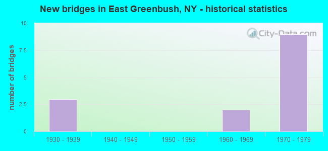
- New bridges - historical statistics
- 31930-1939
- 21960-1969
- 91970-1979


- Bridge Condition - Deck
- 42.9%Good
- 57.1%Satisfactory

- Bridge Condition - Superstructure
- 42.9%Satisfactory
- 42.9%Fair
- 14.3%Poor

- Bridge Condition - Substructure
- 42.9%Satisfactory
- 57.1%Fair

- Bridge Condition - Channel
- 50.0%Satisfactory
- 25.0%Fair
- 25.0%Poor

- Bridge Condition - Culverts
- 66.7%Satisfactory
- 33.3%Fair
Find on map >> Show street view
Structure Number: 100092, Location: 0.4 MI N JCT RTS 4 & 9 (Lat: 42.603925, Lng: -73.707131), Route carried "on" structure: US 4, Year Built: 1930, Status: Open, Structure Length: 0.76m (2.49ft), Average Daily Traffic: 11,740 (year 2020), Truck Traffic: 4%, Average Future Daily Traffic: 11,795 (year 2040), Features Intersected: MILL CREEK
Minimum Vertical Clearance: 30+ m (98+ ft), Kilometerpoint: 0.611, Lanes on structure: 2, Base Highway Network: Yes, Owner: State Highway Agency, Approaching Roadway Width: 11.6m (38.1ft), Skew: 4 degrees, Material/Design: Concrete, Design/Construction: Culvert, Number Of Spans In Main Unit: 1, Length of Maximum Span: 6.7m (22.0ft)
Condition: Channel: Poor, Culverts: Fair, Operating Rating: 97.2 metric tons, Method Used To Determine Operating Rating: Load and Resistance Factor Rating (LRFR) rating reported by rating factor(RF) method using HL-93 loadings, Inventory Rating: 97.2 metric tons, Method Used To Determine Inventory Rating: Load and Resistance Factor Rating (LRFR) rating reported by rating factor(RF) method using HL-93 loadings, Structural Evaluation: Somewhat better than minimum adequacy, Waterway Adequacy: Equal to present desirable criteria, Approach Roadway Alignment: Equal to present desirable criteria, Length Of Structure Improvement: 0.76m (2.49ft), Designated Inspection Frequency: Every 24 months, Inspection Date: April 2020, Bridge Improvement Cost: $472,000, Roadway Improvement Cost: $277,000, Total Project Cost: $749,000 ( Estimate for 2021), Wearing Surface/Protective System: Wearing Surface: Bituminous
Find on map >> Show street view
Structure Number: 107043, Location: .2 MI E JCT I90 & SH 151 (Lat: 42.621014, Lng: -73.688725), Route carried "on" structure: State highway 151, Year Built: 1937, Status: Open, Structure Length: 0.70m (2.30ft), Average Daily Traffic: 2,910 (year 2020), Truck Traffic: 6%, Average Future Daily Traffic: 3,600 (year 2040), Features Intersected: MILL CREEK
Minimum Vertical Clearance: 30+ m (98+ ft), Kilometerpoint: 6.179, Lanes on structure: 2, Base Highway Network: Yes, Owner: State Highway Agency, Approaching Roadway Width: 11.3m (37.1ft), Skew: 21 degrees, Material/Design: Concrete, Design/Construction: Culvert, Number Of Spans In Main Unit: 2, Length of Maximum Span: 3.0m (9.8ft)
Condition: Channel: Fair, Culverts: Satisfactory, Operating Rating: 72.1 metric tons, Method Used To Determine Operating Rating: Field evaluation and documented engineering judgment, Inventory Rating: 32.7 metric tons, Method Used To Determine Inventory Rating: Field evaluation and documented engineering judgment, Structural Evaluation: Equal to present minimum criteria, Waterway Adequacy: Meets minimum limits, Approach Roadway Alignment: Better than present minimum criteria, Length Of Structure Improvement: 0.70m (2.30ft), Designated Inspection Frequency: Every 24 months, Inspection Date: June 2020, Bridge Improvement Cost: $263,000, Roadway Improvement Cost: $154,000, Total Project Cost: $417,000 ( Estimate for 2021), Wearing Surface/Protective System: Wearing Surface: Bituminous
Find on map >> Show street view
Structure Number: 109263, Location: JCT OF RTS I90 & 4 (Lat: 42.627394, Lng: -73.700467), Route carried "on" structure: US 4, Year Built: 1968, Status: Open, Structure Length: 7.62m (25.00ft), Average Daily Traffic: 18,630 (year 2020), Truck Traffic: 7%, Average Future Daily Traffic: 18,717 (year 2040), Design Load: HS 20, Features Intersected: 90I 90I14022024WB, RTE I
Minimum Vertical Clearance: 30+ m (98+ ft), Kilometerpoint: 3.282, Lanes on structure: 4, Lanes under structure: 8, Base Highway Network: Yes, Owner: State Highway Agency, Approaching Roadway Width: 24.4m (80.1ft), Skew: 23 degrees, Material/Design: Steel, Design/Construction: Stringer/Multi-beam, Number Of Spans In Main Unit: 2, Length of Maximum Span: 37.4m (122.7ft), Curb or Sidewalk Widths: Left: 0.5m (1.6ft), Right: 0.5m (1.6ft), Curb-To-Curb Width: 21.4m (70.2ft), Out-to-Out Width: 22.8m (74.8ft)
Condition: Deck: Satisfactory, Superstructure: Fair, Substructure: Fair, Operating Rating: 95.3 metric tons, Method Used To Determine Operating Rating: Load Factor (LF), Inventory Rating: 57.2 metric tons, Method Used To Determine Inventory Rating: Load Factor (LF), Structural Evaluation: Somewhat better than minimum adequacy, Deck Geometry: Superior to present desirable criteria, Underclear: High priority of corrective action, Approach Roadway Alignment: Equal to present desirable criteria, Length Of Structure Improvement: 7.62m (25.00ft), Designated Inspection Frequency: Every 24 months, Inspection Date: September 2021, Bridge Improvement Cost: $4,372,000, Roadway Improvement Cost: $2,560,000, Total Project Cost: $6,932,000 ( Estimate for 2021), Deck Structure Type: Concrete Cast-file-Place, Wearing Surface/Protective System: Wearing Surface: Monolithic Concrete
Find on map >> Show street view
Structure Number: 1092641, Location: JCT RTS I90 & 151 (Lat: 42.620625, Lng: -73.691628), Route carried "on" structure: Interstate 90, Year Built: 1970, Status: Open, Structure Length: 2.90m (9.51ft), Average Daily Traffic: 27,810 (year 2006), Truck Traffic: 9%, Design Load: HS 20, Features Intersected: RTE 151
Minimum Vertical Clearance: 30+ m (98+ ft), Kilometerpoint: 16.331, Lanes on structure: 3, Lanes under structure: 2, Base Highway Network: Yes, Owner: State Highway Agency, Approaching Roadway Width: 16.2m (53.1ft), Skew: 1 degrees, Material/Design: Steel, Design/Construction: Stringer/Multi-beam, Number Of Spans In Main Unit: 1, Length of Maximum Span: 27.7m (90.9ft), Curb-To-Curb Width: 16.2m (53.1ft), Out-to-Out Width: 17.2m (56.4ft)
Condition: Deck: Satisfactory, Superstructure: Satisfactory, Substructure: Satisfactory, Operating Rating: 96.2 metric tons, Method Used To Determine Operating Rating: Load Factor (LF), Inventory Rating: 57.2 metric tons, Method Used To Determine Inventory Rating: Load Factor (LF), Structural Evaluation: Equal to present minimum criteria, Deck Geometry: Equal to present minimum criteria, Underclear: Meets minimum limits, Approach Roadway Alignment: Equal to present desirable criteria, Length Of Structure Improvement: 2.89m (9.48ft), Designated Inspection Frequency: Every 24 months, Inspection Date: May 2020, Bridge Improvement Cost: $1,617,000, Roadway Improvement Cost: $947,000, Total Project Cost: $2,563,000 ( Estimate for 2021), Deck Structure Type: Concrete Cast-file-Place, Wearing Surface/Protective System: Wearing Surface: Monolithic Concrete
Find on map >> Show street view
Structure Number: 1092642, Location: JCT RTS I90 & 151 (Lat: 42.620583, Lng: -73.691992), Route carried "on" structure: Interstate 90, Year Built: 1970, Status: Open, Structure Length: 2.90m (9.51ft), Average Daily Traffic: 16,602 (year 2020), Truck Traffic: 12%, Average Future Daily Traffic: 26,308 (year 2040), Design Load: HS 20, Features Intersected: RTE 151
Minimum Vertical Clearance: 30+ m (98+ ft), Kilometerpoint: 5.969, Lanes on structure: 3, Lanes under structure: 2, Base Highway Network: Yes, Owner: State Highway Agency, Approaching Roadway Width: 16.2m (53.1ft), Skew: 1 degrees, Material/Design: Steel, Design/Construction: Stringer/Multi-beam, Number Of Spans In Main Unit: 1, Length of Maximum Span: 27.7m (90.9ft), Curb-To-Curb Width: 16.2m (53.1ft), Out-to-Out Width: 17.2m (56.4ft)
Condition: Deck: Satisfactory, Superstructure: Satisfactory, Substructure: Satisfactory, Operating Rating: 88.1 metric tons, Method Used To Determine Operating Rating: Load and Resistance Factor Rating (LRFR) rating reported by rating factor(RF) method using HL-93 loadings, Inventory Rating: 68.0 metric tons, Method Used To Determine Inventory Rating: Load and Resistance Factor Rating (LRFR) rating reported by rating factor(RF) method using HL-93 loadings, Structural Evaluation: Equal to present minimum criteria, Deck Geometry: Equal to present minimum criteria, Underclear: High priority of corrective action, Approach Roadway Alignment: Equal to present desirable criteria, Length Of Structure Improvement: 2.89m (9.48ft), Designated Inspection Frequency: Every 24 months, Inspection Date: May 2020, Bridge Improvement Cost: $1,658,000, Roadway Improvement Cost: $971,000, Total Project Cost: $2,629,000 ( Estimate for 2021), Deck Structure Type: Concrete Cast-file-Place, Wearing Surface/Protective System: Wearing Surface: Monolithic Concrete
Find on map >> Show street view
Structure Number: 1092659, Location: 0.1 MI S JCT RT I90 & 151 (Lat: 42.620067, Lng: -73.691681), Route carried "on" structure: Interstate 90, Year Built: 1971, Status: Open, Structure Length: 0.91m (2.99ft), Average Daily Traffic: 33,203 (year 2020), Truck Traffic: 12%, Average Future Daily Traffic: 52,616 (year 2040), Design Load: H 20, Features Intersected: MILL CREEK
Minimum Vertical Clearance: 30+ m (98+ ft), Kilometerpoint: 6.018, Lanes on structure: 6, Base Highway Network: Yes, Owner: State Highway Agency, Approaching Roadway Width: 33.5m (109.9ft), Skew: 21 degrees, Material/Design: Concrete, Design/Construction: Culvert, Number Of Spans In Main Unit: 2, Length of Maximum Span: 3.6m (11.8ft)
Condition: Channel: Satisfactory, Culverts: Satisfactory, Structural Evaluation: Equal to present minimum criteria, Waterway Adequacy: Meets minimum limits, Approach Roadway Alignment: Equal to present desirable criteria, Length Of Structure Improvement: 0.91m (2.99ft), Designated Inspection Frequency: Every 24 months, Inspection Date: June 2021, Bridge Improvement Cost: $917,000, Roadway Improvement Cost: $537,000, Total Project Cost: $1,454,000 ( Estimate for 2021)
Find on map >> Show street view
Structure Number: 109266, Location: 1.5 MI S JCT RT I90 & 151 (Lat: 42.600700, Lng: -73.681864), Route carried "on" structure: County highway , Year Built: 1972, Status: Open, Structure Length: 6.58m (21.59ft), Average Daily Traffic: 883 (year 2020), Truck Traffic: 3%, Average Future Daily Traffic: 1,092 (year 2040), Design Load: HS 20, Features Intersected: 90I 90I 1402 2045 WB, RT, Facility Carried by Structure: ELLIOT ROAD
Minimum Vertical Clearance: 30+ m (98+ ft), Kilometerpoint: 2.333, Lanes on structure: 2, Lanes under structure: 6, Owner: State Highway Agency, Approaching Roadway Width: 10.1m (33.1ft), Skew: 1 degrees, Material/Design: Steel, Design/Construction: Stringer/Multi-beam, Number Of Spans In Main Unit: 2, Length of Maximum Span: 32.0m (105.0ft), Curb-To-Curb Width: 10.1m (33.1ft), Out-to-Out Width: 11.0m (36.1ft)
Condition: Deck: Good, Superstructure: Satisfactory, Substructure: Fair, Operating Rating: 76.8 metric tons, Method Used To Determine Operating Rating: Load and Resistance Factor Rating (LRFR) rating reported by rating factor(RF) method using HL-93 loadings, Inventory Rating: 59.0 metric tons, Method Used To Determine Inventory Rating: Load and Resistance Factor Rating (LRFR) rating reported by rating factor(RF) method using HL-93 loadings, Structural Evaluation: Somewhat better than minimum adequacy, Deck Geometry: Equal to present minimum criteria, Underclear: Somewhat better than minimum adequacy, Approach Roadway Alignment: Equal to present desirable criteria, Length Of Structure Improvement: 6.58m (21.59ft), Designated Inspection Frequency: Every 24 months, Inspection Date: October 2020, Bridge Improvement Cost: $1,929,000, Roadway Improvement Cost: $1,130,000, Total Project Cost: $3,059,000 ( Estimate for 2021), Deck Structure Type: Concrete Cast-file-Place, Wearing Surface/Protective System: Wearing Surface: Monolithic Concrete
Find on map >> Show street view
Structure Number: 1092671, Location: 1.9 MI N EXIT 10 OF I90 (Lat: 42.588464, Lng: -73.676611), Route carried "on" structure: Interstate 90, Year Built: 1972, Status: Open, Structure Length: 2.77m (9.09ft), Average Daily Traffic: 27,810 (year 2006), Truck Traffic: 9%, Design Load: HS 20, Features Intersected: UNFINISHED ROAD
Minimum Vertical Clearance: 30+ m (98+ ft), Kilometerpoint: 9.702, Lanes on structure: 3, Base Highway Network: Yes, Owner: State Highway Agency, Approaching Roadway Width: 16.2m (53.1ft), Material/Design: Steel, Design/Construction: Stringer/Multi-beam, Number Of Spans In Main Unit: 1, Length of Maximum Span: 26.5m (86.9ft), Curb-To-Curb Width: 16.2m (53.1ft), Out-to-Out Width: 17.1m (56.1ft)
Condition: Deck: Good, Superstructure: Fair, Substructure: Fair, Operating Rating: 95.3 metric tons, Method Used To Determine Operating Rating: Load Factor (LF), Inventory Rating: 57.2 metric tons, Method Used To Determine Inventory Rating: Load Factor (LF), Structural Evaluation: Somewhat better than minimum adequacy, Deck Geometry: Equal to present minimum criteria, Approach Roadway Alignment: Equal to present desirable criteria, Length Of Structure Improvement: 2.77m (9.09ft), Designated Inspection Frequency: Every 24 months, Inspection Date: October 2020, Bridge Improvement Cost: $1,425,000, Roadway Improvement Cost: $835,000, Total Project Cost: $2,260,000 ( Estimate for 2021), Deck Structure Type: Concrete Cast-file-Place, Wearing Surface/Protective System: Wearing Surface: Monolithic Concrete
Find on map >> Show street view
Structure Number: 1092672, Location: 1.9 MI N EXIT 10 OF I90 (Lat: 42.588428, Lng: -73.676972), Route carried "on" structure: Interstate 90, Year Built: 1972, Status: Open, Structure Length: 2.77m (9.09ft), Average Daily Traffic: 16,602 (year 2020), Truck Traffic: 12%, Average Future Daily Traffic: 26,308 (year 2040), Design Load: HS 20, Features Intersected: UNFINISHED ROAD
Minimum Vertical Clearance: 30+ m (98+ ft), Kilometerpoint: 9.718, Lanes on structure: 3, Base Highway Network: Yes, Owner: State Highway Agency, Approaching Roadway Width: 16.2m (53.1ft), Material/Design: Steel, Design/Construction: Stringer/Multi-beam, Number Of Spans In Main Unit: 1, Length of Maximum Span: 26.5m (86.9ft), Curb-To-Curb Width: 16.2m (53.1ft), Out-to-Out Width: 17.1m (56.1ft)
Condition: Deck: Good, Superstructure: Fair, Substructure: Fair, Operating Rating: 95.3 metric tons, Method Used To Determine Operating Rating: Load Factor (LF), Inventory Rating: 57.2 metric tons, Method Used To Determine Inventory Rating: Load Factor (LF), Structural Evaluation: Somewhat better than minimum adequacy, Deck Geometry: Equal to present minimum criteria, Approach Roadway Alignment: Equal to present desirable criteria, Length Of Structure Improvement: 2.77m (9.09ft), Designated Inspection Frequency: Every 24 months, Inspection Date: October 2020, Bridge Improvement Cost: $1,385,000, Roadway Improvement Cost: $811,000, Total Project Cost: $2,196,000 ( Estimate for 2021), Deck Structure Type: Concrete Cast-file-Place, Wearing Surface/Protective System: Wearing Surface: Monolithic Concrete
Find on map >> Show street view
Structure Number: 220157, Location: 1 MI NW OF EAST GREENBUSH (Lat: 42.606567, Lng: -73.710269), Route carried "on" structure: Other road , Year Built: 1938, Year Reconstructed: 1991, Status: Posted for load, Structure Length: 0.82m (2.69ft), Average Daily Traffic: 196 (year 2016), Truck Traffic: 5%, Average Future Daily Traffic: 274 (year 2036), Design Load: HS 20, Features Intersected: MILL CREEK, Facility Carried by Structure: OLD TROY ROAD
Minimum Vertical Clearance: 30+ m (98+ ft), Kilometerpoint: 0.579, Lanes on structure: 1, Owner: Town or Township Highway Agency, Approaching Roadway Width: 5.5m (18.0ft), Skew: 3 degrees, Material/Design: Steel, Design/Construction: Stringer/Multi-beam, Number Of Spans In Main Unit: 1, Length of Maximum Span: 7.6m (24.9ft), Curb-To-Curb Width: 5.4m (17.7ft), Out-to-Out Width: 6.1m (20.0ft)
Condition: Deck: Satisfactory, Superstructure: Poor, Substructure: Satisfactory, Channel: Satisfactory, Operating Rating: 84.4 metric tons, Method Used To Determine Operating Rating: Load Factor (LF), Inventory Rating: 60.8 metric tons, Method Used To Determine Inventory Rating: Load Factor (LF), Structural Evaluation: Meets minimum limits, Deck Geometry: High priority of replacement, Waterway Adequacy: Meets minimum limits, Approach Roadway Alignment: Equal to present minimum criteria, Bridge Posting: Required (Relationship of Operating Rating to Maximum Legal Load: > 39.9% below), Length Of Structure Improvement: 0.82m (2.69ft), Designated Inspection Frequency: Every 12 months, Inspection Date: July 2021, Bridge Improvement Cost: $245,000, Roadway Improvement Cost: $143,000, Total Project Cost: $388,000 ( Estimate for 2021), Deck Structure Type: Wood or Timber, Wearing Surface/Protective System: Wearing Surface: Bituminous, Membrane: Other
Find on map >> Show street view
Structure Number: 109263, Location: JCT OF RTS I90 & 4 (Lat: 42.627394, Lng: -73.700467), Route carried "under" structure: Interstate 90, Year Built: 1968, Structure Length: 0. m, Average Daily Traffic: 11,300 (year 1972), Features Intersected: 90I 90I14022024WB, RTE I, Facility Carried by Structure: RTE 4
Minimum Vertical Clearance: 5.28m (17.32ft), Kilometerpoint: 3.540, Lanes on structure: 4, Lanes under structure: 4, Material/Design: Steel, Design/Construction: Stringer/Multi-beam, Length of Maximum Span: 37.4m (122.7ft)
Find on map >> Show street view
Structure Number: 1092641, Location: JCT RTS I90 & 151 (Lat: 42.620625, Lng: -73.691628), Route carried "under" structure: State highway 151, Year Built: 1970, Structure Length: 0. m, Average Daily Traffic: 3,990 (year 1997), Features Intersected: RTE 151, Facility Carried by Structure: RTE I90
Minimum Vertical Clearance: 5.21m (17.09ft), Kilometerpoint: 4.505, Lanes on structure: 3, Lanes under structure: 2, Material/Design: Steel, Design/Construction: Stringer/Multi-beam, Length of Maximum Span: 27.7m (90.9ft)
Find on map >> Show street view
Structure Number: 1092642, Location: JCT RTS I90 & 151 (Lat: 42.620583, Lng: -73.691992), Route carried "under" structure: State highway 151, Year Built: 1970, Structure Length: 0. m, Average Daily Traffic: 3,990 (year 1997), Features Intersected: RTE 151, Facility Carried by Structure: RTE I90
Minimum Vertical Clearance: 4.85m (15.91ft), Kilometerpoint: 4.505, Lanes on structure: 3, Lanes under structure: 2, Material/Design: Steel, Design/Construction: Stringer/Multi-beam, Length of Maximum Span: 27.7m (90.9ft)
Find on map >> Show street view
Structure Number: 109266, Location: 1.5 MI S JCT RT I90 & 151 (Lat: 42.600700, Lng: -73.681864), Route carried "under" structure: Interstate 90, Year Built: 1972, Structure Length: 0. m, Average Daily Traffic: 11,800 (year 1973), Features Intersected: 90I 90I 1402 2045 WB, RT, Facility Carried by Structure: ELLIOT ROAD
Minimum Vertical Clearance: 5.05m (16.57ft), Kilometerpoint: 18.761, Lanes on structure: 2, Lanes under structure: 3, Material/Design: Steel, Design/Construction: Stringer/Multi-beam, Length of Maximum Span: 32.0m (105.0ft)