Bridge Statistics for East Hazel Crest, Illinois (IL)
Condition, Traffic, Stress, Structural Evaluation, Project Costs
- National Bridge Inventory (NBI) Statistics
- 14Number of bridges
- 423ft / 129mTotal length
- $21,870,000Total costs
- 545,900Total average daily traffic
- 132,266Total average daily truck traffic
- National Bridge Inventory (NBI) Registered Bridges for East Hazel Crest
- No street view available for this location
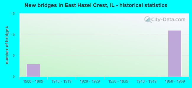
- New bridges - historical statistics
- 31900-1909
- 111950-1959


- Bridge Condition - Deck
- 60.0%Good
- 40.0%Satisfactory

- Bridge Condition - Superstructure
- 40.0%Very good
- 40.0%Good
- 20.0%Satisfactory

- Bridge Condition - Substructure
- 60.0%Good
- 40.0%Satisfactory
Find on map >> Show street view
Structure Number: 160199, Location: 1.5 M S US 6 (Lat: 41.578150, Lng: -87.636450), Route carried "on" structure: State highway 1, Year Built: 1958, Year Reconstructed: 2012, Status: Open, Structure Length: 7.03m (23.06ft), Average Daily Traffic: 35,800 (year 2021), Truck Traffic: 6%, Average Future Daily Traffic: 34,196 (year 2032), Design Load: HS 20, Features Intersected: I- 80,294 TRI STATE
Minimum Vertical Clearance: 30+ m (98+ ft), Kilometerpoint: 505.288, Lanes on structure: 6, Lanes under structure: 9, Base Highway Network: Yes, Owner: State Highway Agency, Approaching Roadway Width: 23.8m (78.1ft), Skew: 30 degrees, Material/Design: Prestressed concrete, Design/Construction: Stringer/Multi-beam, Number Of Spans In Main Unit: 4, Length of Maximum Span: 22.0m (72.2ft), Curb or Sidewalk Widths: Left: 1.5m (4.9ft), Right: 1.5m (4.9ft), Curb-To-Curb Width: 23.8m (78.1ft), Out-to-Out Width: 28.7m (94.2ft)
Condition: Deck: Good, Superstructure: Good, Substructure: Good, Operating Rating: 57.0 metric tons, Method Used To Determine Operating Rating: Load Factor (LF) rating reported by rating factor (RF) method using MS18 loading, Inventory Rating: 34.3 metric tons, Method Used To Determine Inventory Rating: Load Factor (LF) rating reported by rating factor (RF) method using MS18 loading, Structural Evaluation: Better than present minimum criteria, Deck Geometry: Somewhat better than minimum adequacy, Underclear: High priority of corrective action, Approach Roadway Alignment: Better than present minimum criteria, Length Of Structure Improvement: 7.01m (23.00ft), Designated Inspection Frequency: Every 24 months, Inspection Date: May 2021, Bridge Improvement Cost: $1,665,000, Roadway Improvement Cost: $167,000, Total Project Cost: $2,498,000, Deck Structure Type: Concrete Cast-file-Place, Wearing Surface/Protective System: Deck Protection: Epoxy Coated Reinforcing
Find on map >> Show street view
Structure Number: 169716, Location: 1.2 M W ILL 1 P24 (Lat: 41.578036, Lng: -87.661297), Route carried "on" structure: Interstate 80, Year Built: 1958, Status: Open, Structure Length: 53.86m (176.71ft), Average Daily Traffic: 77,950 (year 2020), Truck Traffic: 27%, Average Future Daily Traffic: 66,641 (year 2032), Features Intersected: MARKHAM YD IC RR
Minimum Vertical Clearance: 30+ m (98+ ft), Kilometerpoint: 251.630, Lanes on structure: 3, Lanes under structure: 6, Base Highway Network: Yes, Toll: On toll road, Owner: State Toll Authority, Approaching Roadway Width: 15.8m (51.8ft), Skew: 2 degrees, Material/Design: Prestressed concrete, Number Of Spans In Main Unit: 16, Length of Maximum Span: 48.5m (159.1ft), Curb-To-Curb Width: 12.8m (42.0ft), Out-to-Out Width: 17.7m (58.1ft)
Condition: Deck: Satisfactory, Superstructure: Satisfactory, Substructure: Satisfactory, Operating Rating: 62.9 metric tons, Method Used To Determine Operating Rating: Load Factor (LF) rating reported by rating factor (RF) method using MS18 loading, Inventory Rating: 37.6 metric tons, Method Used To Determine Inventory Rating: Load Factor (LF) rating reported by rating factor (RF) method using MS18 loading, Structural Evaluation: Equal to present minimum criteria, Deck Geometry: Meets minimum limits, Underclear: Meets minimum limits, Approach Roadway Alignment: Equal to present desirable criteria, Length Of Structure Improvement: 53.86m (176.71ft), Designated Inspection Frequency: Every 24 months, Inspection Date: April 2020, Bridge Improvement Cost: $6,457,000, Roadway Improvement Cost: $646,000, Total Project Cost: $9,686,000, Deck Structure Type: Concrete Cast-file-Place, Wearing Surface/Protective System: Wearing Surface: Bituminous
Find on map >> Show street view
Structure Number: 169717, Location: 1.2 M W ILL 1 P24 (Lat: 41.578039, Lng: -87.660994), Route carried "on" structure: Interstate 80, Year Built: 1958, Status: Open, Structure Length: 53.86m (176.71ft), Average Daily Traffic: 77,950 (year 2020), Truck Traffic: 27%, Average Future Daily Traffic: 66,641 (year 2032), Features Intersected: MARKHAM YD IC RR
Minimum Vertical Clearance: 30+ m (98+ ft), Kilometerpoint: 251.646, Lanes on structure: 3, Lanes under structure: 6, Base Highway Network: Yes, Toll: On toll road, Owner: State Toll Authority, Approaching Roadway Width: 15.8m (51.8ft), Skew: 2 degrees, Material/Design: Prestressed concrete, Number Of Spans In Main Unit: 16, Length of Maximum Span: 48.5m (159.1ft), Curb-To-Curb Width: 12.8m (42.0ft), Out-to-Out Width: 17.7m (58.1ft)
Condition: Deck: Satisfactory, Superstructure: Good, Substructure: Satisfactory, Operating Rating: 67.1 metric tons, Method Used To Determine Operating Rating: Load Factor (LF) rating reported by rating factor (RF) method using MS18 loading, Inventory Rating: 40.2 metric tons, Method Used To Determine Inventory Rating: Load Factor (LF) rating reported by rating factor (RF) method using MS18 loading, Structural Evaluation: Equal to present minimum criteria, Deck Geometry: Meets minimum limits, Underclear: Meets minimum limits, Approach Roadway Alignment: Equal to present desirable criteria, Length Of Structure Improvement: 53.86m (176.71ft), Designated Inspection Frequency: Every 24 months, Inspection Date: April 2020, Bridge Improvement Cost: $6,457,000, Roadway Improvement Cost: $646,000, Total Project Cost: $9,686,000, Deck Structure Type: Concrete Cast-file-Place, Wearing Surface/Protective System: Wearing Surface: Bituminous
Find on map >> Show street view
Structure Number: 169718, Location: 0.5 M W ILL 1 P24 (Lat: 41.578100, Lng: -87.646433), Route carried "on" structure: Interstate 80, Year Built: 1958, Status: Open, Structure Length: 6.55m (21.49ft), Average Daily Traffic: 77,950 (year 2020), Truck Traffic: 27%, Average Future Daily Traffic: 66,641 (year 2032), Features Intersected: CENTER ST & IC RR
Minimum Vertical Clearance: 30+ m (98+ ft), Kilometerpoint: 253.046, Lanes on structure: 3, Lanes under structure: 3, Base Highway Network: Yes, Toll: On toll road, Owner: State Toll Authority, Approaching Roadway Width: 15.8m (51.8ft), Material/Design: Prestressed concrete, Design/Construction: Stringer/Multi-beam, Number Of Spans In Main Unit: 3, Length of Maximum Span: 27.4m (89.9ft), Curb-To-Curb Width: 14.2m (46.6ft), Out-to-Out Width: 18.6m (61.0ft)
Condition: Deck: Good, Superstructure: Very good, Substructure: Good, Operating Rating: 63.8 metric tons, Method Used To Determine Operating Rating: Load Factor (LF) rating reported by rating factor (RF) method using MS18 loading, Inventory Rating: 38.2 metric tons, Method Used To Determine Inventory Rating: Load Factor (LF) rating reported by rating factor (RF) method using MS18 loading, Structural Evaluation: Better than present minimum criteria, Deck Geometry: Meets minimum limits, Underclear: Meets minimum limits, Approach Roadway Alignment: Equal to present desirable criteria, Designated Inspection Frequency: Every 24 months, Inspection Date: May 2021, Deck Structure Type: Concrete Cast-file-Place, Wearing Surface/Protective System: Wearing Surface: Bituminous, Membrane: Built-up
Find on map >> Show street view
Structure Number: 169719, Location: 0.5 M W ILL 1 P24 (Lat: 41.578100, Lng: -87.646281), Route carried "on" structure: Interstate 80, Year Built: 1958, Status: Open, Structure Length: 7.62m (25.00ft), Average Daily Traffic: 77,950 (year 2020), Truck Traffic: 27%, Average Future Daily Traffic: 66,641 (year 2032), Features Intersected: CENTER ST & IC RR
Minimum Vertical Clearance: 30+ m (98+ ft), Kilometerpoint: 253.062, Lanes on structure: 3, Lanes under structure: 3, Base Highway Network: Yes, Toll: On toll road, Owner: State Toll Authority, Approaching Roadway Width: 15.8m (51.8ft), Material/Design: Prestressed concrete, Design/Construction: Stringer/Multi-beam, Number Of Spans In Main Unit: 3, Length of Maximum Span: 27.4m (89.9ft), Curb-To-Curb Width: 14.2m (46.6ft), Out-to-Out Width: 18.6m (61.0ft)
Condition: Deck: Good, Superstructure: Very good, Substructure: Good, Operating Rating: 68.7 metric tons, Method Used To Determine Operating Rating: Load Factor (LF) rating reported by rating factor (RF) method using MS18 loading, Inventory Rating: 41.1 metric tons, Method Used To Determine Inventory Rating: Load Factor (LF) rating reported by rating factor (RF) method using MS18 loading, Structural Evaluation: Better than present minimum criteria, Deck Geometry: Meets minimum limits, Underclear: Meets minimum limits, Approach Roadway Alignment: Equal to present desirable criteria, Designated Inspection Frequency: Every 24 months, Inspection Date: May 2021, Deck Structure Type: Concrete Cast-file-Place, Wearing Surface/Protective System: Wearing Surface: Bituminous, Membrane: Built-up
Find on map >> Show street view
Structure Number: 160199, Location: 1.5 M S US 6 (Lat: 41.578150, Lng: -87.636450), Route carried "under" structure: Interstate 80, Year Built: 1958, Structure Length: 0. m, Average Daily Traffic: 140,800 (year 2020), Truck Traffic: 27%, Features Intersected: I- 80,294 TRI STATE, Facility Carried by Structure: IL 1 (HALSTED ST
Minimum Vertical Clearance: 5.21m (17.09ft), Kilometerpoint: 253.771, Lanes on structure: 6, Lanes under structure: 9, Material/Design: Prestressed concrete, Design/Construction: Stringer/Multi-beam, Length of Maximum Span: 22.0m (72.2ft)
Find on map >> Show street view
Structure Number: 16307, Location: 0.75 M E WESTERN P2 (Lat: 41.579050, Lng: -87.659108), Route carried "under" structure: Other road , Year Built: 1900, Structure Length: 0. m, Average Daily Traffic: 12,600 (year 2018), Truck Traffic: 15%, Features Intersected: 171ST ST, Facility Carried by Structure: RR
Minimum Vertical Clearance: 3.73m (12.24ft), Kilometerpoint: 0.048, Lanes under structure: 4, Material/Design: Concrete, Length of Maximum Span: 6.4m (21.0ft)
Find on map >> Show street view
Structure Number: 163071, Location: 0.8 M E WESTERN P2 (Lat: 41.579050, Lng: -87.658203), Route carried "under" structure: Other road , Year Built: 1900, Structure Length: 0. m, Average Daily Traffic: 12,600 (year 2018), Truck Traffic: 15%, Features Intersected: 171ST ST, Facility Carried by Structure: RR
Minimum Vertical Clearance: 3.84m (12.60ft), Kilometerpoint: 0.113, Lanes under structure: 4, Material/Design: Concrete, Length of Maximum Span: 6.4m (21.0ft)
Find on map >> Show street view
Structure Number: 163072, Location: 0.85 M E WESTERN P2 (Lat: 41.579056, Lng: -87.657069), Route carried "under" structure: Other road , Year Built: 1900, Structure Length: 0. m, Average Daily Traffic: 12,600 (year 2018), Truck Traffic: 15%, Features Intersected: 171ST ST, Facility Carried by Structure: RR
Minimum Vertical Clearance: 3.84m (12.60ft), Kilometerpoint: 0.193, Lanes under structure: 4, Material/Design: Concrete, Length of Maximum Span: 6.4m (21.0ft)
Find on map >> Show street view
Structure Number: 169715, Location: 1.5 M W ILL 1 P24 (Lat: 41.578258, Lng: -87.665550), Route carried "under" structure: Other road , Year Built: 1958, Structure Length: 0. m, Average Daily Traffic: 10,600 (year 2021), Truck Traffic: 9%, Features Intersected: DIXIE HIGHWAY, Facility Carried by Structure: I-294,80 WB
Minimum Vertical Clearance: 4.34m (14.24ft), Kilometerpoint: 2.543, Lanes on structure: 3, Lanes under structure: 4, Toll: On toll road, Material/Design: Prestressed concrete, Design/Construction: Stringer/Multi-beam, Length of Maximum Span: 23.8m (78.1ft)
Find on map >> Show street view
Structure Number: 169716, Location: 1.2 M W ILL 1 P24 (Lat: 41.577933, Lng: -87.655331), Route carried "under" structure: Other road , Year Built: 1958, Structure Length: 0. m, Average Daily Traffic: 4,200 (year 2018), Truck Traffic: 14%, Features Intersected: MARKHAM YD IC RR, Facility Carried by Structure: I-294,80 EB
Minimum Vertical Clearance: 5.03m (16.50ft), Kilometerpoint: 0.225, Lanes on structure: 3, Lanes under structure: 2, Toll: On toll road, Material/Design: Prestressed concrete, Length of Maximum Span: 48.5m (159.1ft)
Find on map >> Show street view
Structure Number: 169716, Location: 1.2 M W ILL 1 P24 (Lat: 41.577758, Lng: -87.660436), Route carried "under" structure: Other road , Year Built: 1958, Structure Length: 0. m, Average Daily Traffic: 350 (year 2018), Truck Traffic: 17%, Features Intersected: MARKHAM YD IC RR, Facility Carried by Structure: I-294,80 EB
Minimum Vertical Clearance: 6.91m (22.67ft), Kilometerpoint: 0.097, Lanes on structure: 3, Lanes under structure: 4, Toll: On toll road, Material/Design: Prestressed concrete, Length of Maximum Span: 48.5m (159.1ft)
Find on map >> Show street view
Structure Number: 169717, Location: 1.2 M W ILL 1 P24 (Lat: 41.578292, Lng: -87.660158), Route carried "under" structure: Other road , Year Built: 1958, Structure Length: 0. m, Average Daily Traffic: 350 (year 2018), Truck Traffic: 17%, Features Intersected: MARKHAM YD IC RR, Facility Carried by Structure: I-294,80 WB
Minimum Vertical Clearance: 6.91m (22.67ft), Kilometerpoint: 0.048, Lanes on structure: 3, Lanes under structure: 4, Toll: On toll road, Material/Design: Prestressed concrete, Length of Maximum Span: 48.5m (159.1ft)
Find on map >> Show street view
Structure Number: 169717, Location: 1.2 M W ILL 1 P24 (Lat: 41.578328, Lng: -87.655036), Route carried "under" structure: Other road , Year Built: 1958, Structure Length: 0. m, Average Daily Traffic: 4,200 (year 2018), Truck Traffic: 14%, Features Intersected: MARKHAM YD IC RR, Facility Carried by Structure: I-294,80 WB
Minimum Vertical Clearance: 5.03m (16.50ft), Kilometerpoint: 0.177, Lanes on structure: 3, Lanes under structure: 2, Toll: On toll road, Material/Design: Prestressed concrete, Length of Maximum Span: 48.5m (159.1ft)