Bridge Statistics for East Islip, New York (NY)
Condition, Traffic, Stress, Structural Evaluation, Project Costs
- National Bridge Inventory (NBI) Statistics
- 11Number of bridges
- 56ft / 17.1mTotal length
- $47,351,000Total costs
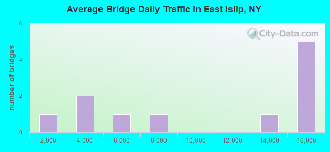
- 108,716Total average daily traffic
- 798Total average daily truck traffic
- National Bridge Inventory (NBI) Registered Bridges for East Islip
- No street view available for this location
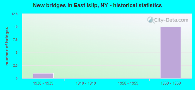
- New bridges - historical statistics
- 11930-1939
- 101960-1969
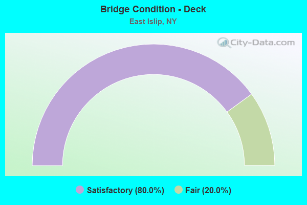
- Bridge Condition - Deck
- 80.0%Satisfactory
- 20.0%Fair
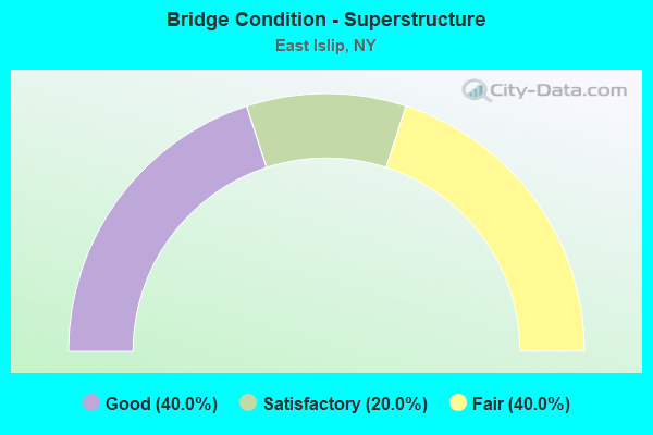
- Bridge Condition - Superstructure
- 40.0%Good
- 20.0%Satisfactory
- 40.0%Fair
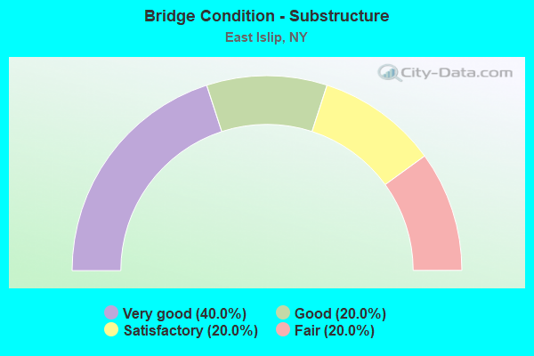
- Bridge Condition - Substructure
- 40.0%Very good
- 20.0%Good
- 20.0%Satisfactory
- 20.0%Fair
Find on map >> Show street view
Structure Number: 1059959, Location: .4 MI SE JCT RTS 27+SSP (Lat: 40.741031, Lng: -73.173392), Route carried "on" structure: State highway 908M, Year Built: 1960, Status: Open, Structure Length: 2.13m (6.99ft), Average Daily Traffic: 14,917 (year 2019), Truck Traffic: 1%, Average Future Daily Traffic: 17,743 (year 2040), Design Load: H 20, Features Intersected: JEFFERSON STREET
Minimum Vertical Clearance: 30+ m (98+ ft), Kilometerpoint: 24.521, Lanes on structure: 6, Lanes under structure: 2, Base Highway Network: Yes, Owner: State Highway Agency, Approaching Roadway Width: 28.7m (94.2ft), Skew: 22 degrees, Material/Design: Concrete, Design/Construction: Frame, Number Of Spans In Main Unit: 1, Length of Maximum Span: 19.8m (65.0ft), Curb-To-Curb Width: 25.5m (83.7ft), Out-to-Out Width: 32.5m (106.6ft)
Condition: Deck: Satisfactory, Superstructure: Good, Substructure: Very good, Operating Rating: 58.3 metric tons, Method Used To Determine Operating Rating: Field evaluation and documented engineering judgment, Inventory Rating: 23.0 metric tons, Method Used To Determine Inventory Rating: Field evaluation and documented engineering judgment, Structural Evaluation: Somewhat better than minimum adequacy, Deck Geometry: Meets minimum limits, Underclear: Meets minimum limits, Approach Roadway Alignment: Equal to present desirable criteria, Length Of Structure Improvement: 2.13m (6.99ft), Designated Inspection Frequency: Every 24 months, Inspection Date: June 2021, Bridge Improvement Cost: $5,318,000, Roadway Improvement Cost: $3,114,000, Total Project Cost: $8,432,000 ( Estimate for 2021), Wearing Surface/Protective System: Wearing Surface: Bituminous, Membrane: Preformed Fabric
Find on map >> Show street view
Structure Number: 1059969, Location: .5 MI SE JCT RTS 27+SSP (Lat: 40.739881, Lng: -73.172578), Route carried "on" structure: State highway 908M, Year Built: 1960, Status: Open, Structure Length: 5.30m (17.39ft), Average Daily Traffic: 14,917 (year 2019), Truck Traffic: 1%, Average Future Daily Traffic: 17,743 (year 2040), Design Load: H 20, Features Intersected: HAWTHORNE AVE, LIRR-MONT
Minimum Vertical Clearance: 30+ m (98+ ft), Kilometerpoint: 24.650, Lanes on structure: 6, Lanes under structure: 2, Base Highway Network: Yes, Owner: State Highway Agency, Approaching Roadway Width: 25.0m (82.0ft), Skew: 21 degrees, Material/Design: Steel, Design/Construction: Stringer/Multi-beam, Number Of Spans In Main Unit: 2, Length of Maximum Span: 25.9m (85.0ft), Curb-To-Curb Width: 24.9m (81.7ft), Out-to-Out Width: 32.1m (105.3ft)
Condition: Deck: Satisfactory, Superstructure: Fair, Substructure: Fair, Operating Rating: 64.4 metric tons, Method Used To Determine Operating Rating: Load Factor (LF), Inventory Rating: 38.1 metric tons, Method Used To Determine Inventory Rating: Load Factor (LF), Structural Evaluation: Somewhat better than minimum adequacy, Deck Geometry: Meets minimum limits, Underclear: Better than present minimum criteria, Approach Roadway Alignment: Equal to present desirable criteria, Length Of Structure Improvement: 5.30m (17.39ft), Designated Inspection Frequency: Every 24 months, Inspection Date: September 2021, Bridge Improvement Cost: $8,623,000, Roadway Improvement Cost: $5,050,000, Total Project Cost: $13,673,000 ( Estimate for 2021), Deck Structure Type: Concrete Cast-file-Place, Wearing Surface/Protective System: Wearing Surface: Bituminous, Membrane: Preformed Fabric
Find on map >> Show street view
Structure Number: 1059979, Location: .7 MI SE JCT SH 27 & SSP (Lat: 40.737356, Lng: -73.171522), Route carried "on" structure: State highway 908M, Year Built: 1960, Status: Open, Structure Length: 2.19m (7.19ft), Average Daily Traffic: 14,917 (year 2019), Truck Traffic: 1%, Average Future Daily Traffic: 17,743 (year 2040), Design Load: H 20, Features Intersected: UNION BLVD - CR50
Minimum Vertical Clearance: 30+ m (98+ ft), Kilometerpoint: 24.972, Lanes on structure: 8, Lanes under structure: 2, Base Highway Network: Yes, Owner: State Highway Agency, Approaching Roadway Width: 34.1m (111.9ft), Skew: 20 degrees, Material/Design: Concrete, Design/Construction: Frame, Number Of Spans In Main Unit: 1, Length of Maximum Span: 20.1m (65.9ft), Curb-To-Curb Width: 34.1m (111.9ft), Out-to-Out Width: 41.8m (137.1ft)
Condition: Deck: Satisfactory, Superstructure: Good, Substructure: Very good, Operating Rating: 58.7 metric tons, Method Used To Determine Operating Rating: Field evaluation and documented engineering judgment, Inventory Rating: 23.0 metric tons, Method Used To Determine Inventory Rating: Field evaluation and documented engineering judgment, Structural Evaluation: Somewhat better than minimum adequacy, Deck Geometry: Somewhat better than minimum adequacy, Underclear: Equal to present minimum criteria, Approach Roadway Alignment: Equal to present desirable criteria, Length Of Structure Improvement: 2.19m (7.19ft), Designated Inspection Frequency: Every 24 months, Inspection Date: July 2021, Bridge Improvement Cost: $5,777,000, Roadway Improvement Cost: $3,383,000, Total Project Cost: $9,160,000 ( Estimate for 2021), Wearing Surface/Protective System: Wearing Surface: Bituminous, Membrane: Preformed Fabric
Find on map >> Show street view
Structure Number: 1059989, Location: JCT RTS 27A + SSP (Lat: 40.735625, Lng: -73.170900), Route carried "on" structure: State highway 908M, Year Built: 1960, Status: Open, Structure Length: 3.41m (11.19ft), Average Daily Traffic: 14,917 (year 2019), Truck Traffic: 2%, Average Future Daily Traffic: 17,743 (year 2040), Design Load: H 20, Features Intersected: 27A 27A07051149 E/B, RTE
Minimum Vertical Clearance: 30+ m (98+ ft), Kilometerpoint: 25.181, Lanes on structure: 8, Lanes under structure: 4, Base Highway Network: Yes, Owner: State Highway Agency, Approaching Roadway Width: 32.3m (106.0ft), Skew: 20 degrees, Material/Design: Concrete continuous, Design/Construction: Frame, Number Of Spans In Main Unit: 2, Length of Maximum Span: 15.8m (51.8ft), Curb-To-Curb Width: 32.3m (106.0ft), Out-to-Out Width: 39.7m (130.2ft)
Condition: Deck: Fair, Superstructure: Fair, Substructure: Satisfactory, Operating Rating: 56.3 metric tons, Method Used To Determine Operating Rating: Field evaluation and documented engineering judgment, Inventory Rating: 22.9 metric tons, Method Used To Determine Inventory Rating: Field evaluation and documented engineering judgment, Structural Evaluation: Somewhat better than minimum adequacy, Deck Geometry: Meets minimum limits, Underclear: Equal to present minimum criteria, Approach Roadway Alignment: Equal to present desirable criteria, Length Of Structure Improvement: 3.41m (11.19ft), Designated Inspection Frequency: Every 24 months, Inspection Date: June 2021, Bridge Improvement Cost: $7,634,000, Roadway Improvement Cost: $4,470,000, Total Project Cost: $12,104,000 ( Estimate for 2021), Wearing Surface/Protective System: Wearing Surface: Bituminous, Membrane: Preformed Fabric
Find on map >> Show street view
Structure Number: 105999, Location: 1.2 MI S JCT SH 27A & SSP (Lat: 40.719078, Lng: -73.163625), Route carried "on" structure: City street , Year Built: 1960, Status: Open, Structure Length: 4.02m (13.19ft), Average Daily Traffic: 2,673 (year 2018), Truck Traffic: 2%, Average Future Daily Traffic: 3,307 (year 2040), Design Load: HS 20, Features Intersected: 908M908M07021169, NB, RT, Facility Carried by Structure: TIMBER POINT ROAD
Minimum Vertical Clearance: 30+ m (98+ ft), Kilometerpoint: 0.225, Lanes on structure: 2, Lanes under structure: 4, Owner: State Highway Agency, Approaching Roadway Width: 8.5m (27.9ft), Skew: 2 degrees, Material/Design: Concrete continuous, Design/Construction: Frame, Number Of Spans In Main Unit: 2, Length of Maximum Span: 18.8m (61.7ft), Curb or Sidewalk Widths: Left: 1.5m (4.9ft), Right: 1.5m (4.9ft), Curb-To-Curb Width: 8.5m (27.9ft), Out-to-Out Width: 12.5m (41.0ft)
Condition: Deck: Satisfactory, Superstructure: Satisfactory, Substructure: Good, Operating Rating: 86.0 metric tons, Method Used To Determine Operating Rating: Field evaluation and documented engineering judgment, Inventory Rating: 32.7 metric tons, Method Used To Determine Inventory Rating: Field evaluation and documented engineering judgment, Structural Evaluation: Equal to present minimum criteria, Deck Geometry: Meets minimum limits, Underclear: High priority of corrective action, Approach Roadway Alignment: Equal to present desirable criteria, Length Of Structure Improvement: 4.02m (13.19ft), Designated Inspection Frequency: Every 24 months, Inspection Date: August 2021, Bridge Improvement Cost: $2,511,000, Roadway Improvement Cost: $1,471,000, Total Project Cost: $3,982,000 ( Estimate for 2021), Wearing Surface/Protective System: Wearing Surface: Bituminous, Membrane: Preformed Fabric
Find on map >> Show street view
Structure Number: 1059959, Location: .4 MI SE JCT RTS 27+SSP (Lat: 40.741031, Lng: -73.173392), Route carried "under" structure: Alternate City street , Year Built: 1960, Structure Length: 0. m, Average Daily Traffic: 1,700 (year 2021), Features Intersected: JEFFERSON STREET, Facility Carried by Structure: RTE 908M
Minimum Vertical Clearance: 6.40m (21.00ft), Kilometerpoint: 0.000, Lanes on structure: 6, Lanes under structure: 2, Material/Design: Concrete, Design/Construction: Frame, Length of Maximum Span: 19.8m (65.0ft)
Find on map >> Show street view
Structure Number: 1059969, Location: .5 MI SE JCT RTS 27+SSP (Lat: 40.739881, Lng: -73.172578), Route carried "under" structure: Other road , Year Built: 1960, Structure Length: 0. m, Average Daily Traffic: 2,000 (year 2021), Features Intersected: HAWTHORNE AVE, LIRR-MONT, Facility Carried by Structure: RTE 908M
Minimum Vertical Clearance: 7.67m (25.16ft), Kilometerpoint: 0.000, Lanes on structure: 6, Lanes under structure: 2, Material/Design: Steel, Design/Construction: Stringer/Multi-beam, Length of Maximum Span: 25.9m (85.0ft)
Find on map >> Show street view
Structure Number: 1059979, Location: .7 MI SE JCT SH 27 & SSP (Lat: 40.737356, Lng: -73.171522), Route carried "under" structure: County highway , Year Built: 1960, Structure Length: 0. m, Average Daily Traffic: 7,639 (year 2004), Features Intersected: UNION BLVD - CR50, Facility Carried by Structure: RTE 908M
Minimum Vertical Clearance: 4.80m (15.75ft), Kilometerpoint: 0.000, Lanes on structure: 8, Lanes under structure: 2, Material/Design: Concrete, Design/Construction: Frame, Length of Maximum Span: 20.1m (65.9ft)
Find on map >> Show street view
Structure Number: 1059989, Location: JCT RTS 27A + SSP (Lat: 40.735625, Lng: -73.170900), Route carried "under" structure: Alternate State highway 27A, Year Built: 1960, Structure Length: 0. m, Average Daily Traffic: 13,900 (year 1972), Features Intersected: 27A 27A07051149 E/B, RTE, Facility Carried by Structure: RTE 908M
Minimum Vertical Clearance: 4.88m (16.01ft), Kilometerpoint: 23.878, Lanes on structure: 8, Lanes under structure: 2, Material/Design: Concrete continuous, Design/Construction: Frame, Length of Maximum Span: 15.8m (51.8ft)
Find on map >> Show street view
Structure Number: 105999, Location: 1.2 MI S JCT SH 27A & SSP (Lat: 40.719078, Lng: -73.163625), Route carried "under" structure: State highway 908M, Year Built: 1960, Structure Length: 0. m, Average Daily Traffic: 5,436 (year 2002), Features Intersected: 908M908M07021169, NB, RT, Facility Carried by Structure: TIMBER POINT ROAD
Minimum Vertical Clearance: 4.34m (14.24ft), Kilometerpoint: 26.886, Lanes on structure: 2, Lanes under structure: 2, Material/Design: Concrete continuous, Design/Construction: Frame, Length of Maximum Span: 18.8m (61.7ft)
Find on map >> Show street view
Structure Number: 771006, Location: 1.0 MI EAST OF ISLIP (Lat: 40.737378, Lng: -73.191961), Route carried "under" structure: County highway , Year Built: 1932, Structure Length: 0. m, Average Daily Traffic: 15,700 (year 1977), Features Intersected: CARLETON AVE, Facility Carried by Structure: LIRR MONTAUK BR
Minimum Vertical Clearance: 4.14m (13.58ft), Kilometerpoint: 0.000, Lanes under structure: 2, Material/Design: Steel, Design/Construction: Girder and Floorbeam System, Length of Maximum Span: 14.0m (45.9ft)