Bridge Statistics for East Syracuse, New York (NY)
Condition, Traffic, Stress, Structural Evaluation, Project Costs
- National Bridge Inventory (NBI) Statistics
- 13Number of bridges
- 564ft / 172mTotal length
- $69,289,000Total costs
- 243,954Total average daily traffic
- 9,574Total average daily truck traffic
- National Bridge Inventory (NBI) Registered Bridges for East Syracuse
- No street view available for this location
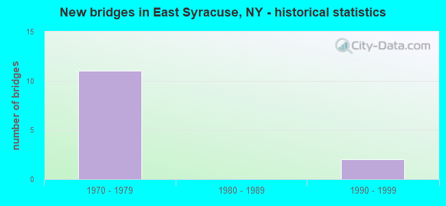
- New bridges - historical statistics
- 111970-1979
- 21990-1999

- Reconstructed bridges - Historical Statistics
- 21990-1999
- 02000-2009
- 22010-2019


- Bridge Condition - Deck
- 28.6%Excellent
- 42.9%Satisfactory
- 28.6%Fair

- Bridge Condition - Superstructure
- 14.3%Good
- 57.1%Satisfactory
- 28.6%Fair

- Bridge Condition - Substructure
- 57.1%Satisfactory
- 42.9%Fair
Find on map >> Show street view
Structure Number: 104491, Location: .9 MI W JCT SH 290 & I481 (Lat: 43.062886, Lng: -76.068292), Route carried "on" structure: State highway 290, Year Built: 1995, Status: Open, Structure Length: 8.05m (26.41ft), Average Daily Traffic: 11,178 (year 2018), Truck Traffic: 9%, Average Future Daily Traffic: 13,579 (year 2040), Design Load: HS 25 or greater, Features Intersected: E FIRST ST, CSX TRANS/ A
Minimum Vertical Clearance: 30+ m (98+ ft), Kilometerpoint: 7.257, Lanes on structure: 3, Lanes under structure: 2, Base Highway Network: Yes, Owner: State Highway Agency, Approaching Roadway Width: 12.2m (40.0ft), Skew: 2 degrees, Material/Design: Steel continuous, Design/Construction: Stringer/Multi-beam, Number Of Spans In Main Unit: 2, Length of Maximum Span: 39.3m (128.9ft), Curb or Sidewalk Widths: Left: 1.5m (4.9ft), Right: 1.5m (4.9ft), Curb-To-Curb Width: 12.2m (40.0ft), Out-to-Out Width: 15.8m (51.8ft)
Condition: Deck: Satisfactory, Superstructure: Good, Substructure: Satisfactory, Operating Rating: 89.8 metric tons, Method Used To Determine Operating Rating: Load Factor (LF), Inventory Rating: 53.5 metric tons, Method Used To Determine Inventory Rating: Load Factor (LF), Structural Evaluation: Equal to present minimum criteria, Deck Geometry: Meets minimum limits, Underclear: Meets minimum limits, Approach Roadway Alignment: Equal to present desirable criteria, Length Of Structure Improvement: 8.04m (26.38ft), Designated Inspection Frequency: Every 24 months, Inspection Date: May 2021, Bridge Improvement Cost: $2,898,000, Roadway Improvement Cost: $1,697,000, Total Project Cost: $4,595,000 ( Estimate for 2021), Deck Structure Type: Concrete Cast-file-Place, Wearing Surface/Protective System: Wearing Surface: Integral Concrete, Deck Protection: Epoxy Coated Reinforcing
Find on map >> Show street view
Structure Number: 1064689, Location: JCT I690 & THOMPSON ROAD (Lat: 43.058294, Lng: -76.083792), Route carried "on" structure: State highway 635, Year Built: 1971, Status: Open, Structure Length: 10.39m (34.09ft), Average Daily Traffic: 17,984 (year 2019), Truck Traffic: 6%, Average Future Daily Traffic: 18,068 (year 2040), Design Load: HS 20, Features Intersected: WB COLLECT/DISTR, 690I69
Minimum Vertical Clearance: 30+ m (98+ ft), Kilometerpoint: 0.274, Lanes on structure: 6, Lanes under structure: 9, Base Highway Network: Yes, Owner: State Highway Agency, Approaching Roadway Width: 26.5m (86.9ft), Skew: 22 degrees, Material/Design: Steel, Design/Construction: Stringer/Multi-beam, Number Of Spans In Main Unit: 4, Length of Maximum Span: 26.2m (86.0ft), Curb-To-Curb Width: 26.8m (87.9ft), Out-to-Out Width: 28.3m (92.8ft)
Condition: Deck: Fair, Superstructure: Satisfactory, Substructure: Fair, Operating Rating: 82.6 metric tons, Method Used To Determine Operating Rating: Load Factor (LF), Inventory Rating: 49.9 metric tons, Method Used To Determine Inventory Rating: Load Factor (LF), Structural Evaluation: Somewhat better than minimum adequacy, Deck Geometry: Better than present minimum criteria, Underclear: High priority of corrective action, Approach Roadway Alignment: Equal to present desirable criteria, Length Of Structure Improvement: 10.39m (34.09ft), Designated Inspection Frequency: Every 24 months, Inspection Date: November 2020, Bridge Improvement Cost: $6,177,000, Roadway Improvement Cost: $3,618,000, Total Project Cost: $9,795,000 ( Estimate for 2021), Deck Structure Type: Concrete Cast-file-Place, Wearing Surface/Protective System: Wearing Surface: Monolithic Concrete
Find on map >> Show street view
Structure Number: 1064691, Location: 1. MI W JCT I-690 WB+481I (Lat: 43.057353, Lng: -76.066989), Route carried "on" structure: Interstate 690, Year Built: 1971, Year Reconstructed: 2019, Status: Open, Structure Length: 5.27m (17.29ft), Average Daily Traffic: 25,050 (year 2003), Truck Traffic: 13%, Design Load: HS 20, Features Intersected: BRIDGE STREET, BRIDGE ST
Minimum Vertical Clearance: 30+ m (98+ ft), Kilometerpoint: 21.174, Lanes on structure: 4, Lanes under structure: 6, Base Highway Network: Yes, Owner: State Highway Agency, Approaching Roadway Width: 15.2m (49.9ft), Skew: 20 degrees, Material/Design: Steel, Design/Construction: Stringer/Multi-beam, Number Of Spans In Main Unit: 2, Length of Maximum Span: 26.8m (87.9ft), Curb-To-Curb Width: 19.5m (64.0ft), Out-to-Out Width: 20.4m (66.9ft)
Condition: Deck: Excellent, Superstructure: Satisfactory, Substructure: Satisfactory, Operating Rating: 75.3 metric tons, Method Used To Determine Operating Rating: Load Factor (LF), Inventory Rating: 44.5 metric tons, Method Used To Determine Inventory Rating: Load Factor (LF), Structural Evaluation: Equal to present minimum criteria, Deck Geometry: Somewhat better than minimum adequacy, Underclear: Somewhat better than minimum adequacy, Approach Roadway Alignment: Equal to present desirable criteria, Length Of Structure Improvement: 5.27m (17.29ft), Designated Inspection Frequency: Every 24 months, Inspection Date: November 2020, Bridge Improvement Cost: $2,221,000, Roadway Improvement Cost: $1,301,000, Total Project Cost: $3,522,000 ( Estimate for 2021), Deck Structure Type: Concrete Cast-file-Place, Wearing Surface/Protective System: Wearing Surface: Monolithic Concrete
Find on map >> Show street view
Structure Number: 1064692, Location: 1. MI W JCT I-690 EB+481I (Lat: 43.057117, Lng: -76.066964), Route carried "on" structure: Interstate 690, Year Built: 1971, Year Reconstructed: 2019, Status: Open, Structure Length: 5.27m (17.29ft), Average Daily Traffic: 15,606 (year 2018), Truck Traffic: 5%, Average Future Daily Traffic: 22,511 (year 2040), Design Load: HS 20, Features Intersected: BRIDGE STREET
Minimum Vertical Clearance: 30+ m (98+ ft), Kilometerpoint: 21.142, Lanes on structure: 4, Lanes under structure: 5, Base Highway Network: Yes, Owner: State Highway Agency, Approaching Roadway Width: 19.5m (64.0ft), Skew: 20 degrees, Material/Design: Steel, Design/Construction: Stringer/Multi-beam, Number Of Spans In Main Unit: 2, Length of Maximum Span: 26.8m (87.9ft), Curb-To-Curb Width: 19.5m (64.0ft), Out-to-Out Width: 20.4m (66.9ft)
Condition: Deck: Excellent, Superstructure: Satisfactory, Substructure: Satisfactory, Operating Rating: 77.1 metric tons, Method Used To Determine Operating Rating: Load Factor (LF), Inventory Rating: 46.3 metric tons, Method Used To Determine Inventory Rating: Load Factor (LF), Structural Evaluation: Equal to present minimum criteria, Deck Geometry: Somewhat better than minimum adequacy, Underclear: Somewhat better than minimum adequacy, Approach Roadway Alignment: Equal to present desirable criteria, Length Of Structure Improvement: 5.27m (17.29ft), Designated Inspection Frequency: Every 24 months, Inspection Date: November 2021, Bridge Improvement Cost: $2,198,000, Roadway Improvement Cost: $1,287,000, Total Project Cost: $3,486,000 ( Estimate for 2021), Deck Structure Type: Concrete Cast-file-Place, Wearing Surface/Protective System: Wearing Surface: Monolithic Concrete
Find on map >> Show street view
Structure Number: 1093571, Location: .2 MI N JCT I481SB &SH290 (Lat: 43.067589, Lng: -76.052956), Route carried "on" structure: Interstate 481, Year Built: 1972, Year Reconstructed: 2003, Status: Open, Structure Length: 65.41m (214.60ft), Average Daily Traffic: 22,378 (year 2008), Truck Traffic: 10%, Design Load: HS 20, Features Intersected: CSX TRANS/AMTRAK
Minimum Vertical Clearance: 30+ m (98+ ft), Kilometerpoint: 12.212, Lanes on structure: 2, Base Highway Network: Yes, Owner: State Highway Agency, Approaching Roadway Width: 11.3m (37.1ft), Material/Design: Steel, Design/Construction: Stringer/Multi-beam, Number Of Spans In Main Unit: 15, Length of Maximum Span: 59.7m (195.9ft), Curb-To-Curb Width: 10.2m (33.5ft), Out-to-Out Width: 11.3m (37.1ft)
Condition: Deck: Satisfactory, Superstructure: Fair, Substructure: Fair, Operating Rating: 65.3 metric tons, Method Used To Determine Operating Rating: Load Factor (LF), Inventory Rating: 39.0 metric tons, Method Used To Determine Inventory Rating: Load Factor (LF), Structural Evaluation: Somewhat better than minimum adequacy, Deck Geometry: Meets minimum limits, Underclear: Equal to present minimum criteria, Approach Roadway Alignment: Equal to present desirable criteria, Length Of Structure Improvement: 65.41m (214.60ft), Designated Inspection Frequency: Every 24 months, Inspection Date: October 2021, Bridge Improvement Cost: $13,741,000, Roadway Improvement Cost: $8,047,000, Total Project Cost: $21,788,000 ( Estimate for 2021), Deck Structure Type: Concrete Cast-file-Place, Wearing Surface/Protective System: Wearing Surface: Latex Concrete
Find on map >> Show street view
Structure Number: 1093572, Location: .2 MI N JCT I481NB &SH290 (Lat: 43.067658, Lng: -76.052656), Route carried "on" structure: Interstate 481, Year Built: 1972, Status: Open, Structure Length: 64.83m (212.70ft), Average Daily Traffic: 15,238 (year 2019), Truck Traffic: 7%, Average Future Daily Traffic: 21,980 (year 2040), Design Load: HS 20, Features Intersected: CSX TRANS/AMTRAK
Minimum Vertical Clearance: 30+ m (98+ ft), Kilometerpoint: 12.196, Lanes on structure: 2, Base Highway Network: Yes, Owner: State Highway Agency, Approaching Roadway Width: 11.3m (37.1ft), Material/Design: Steel, Design/Construction: Stringer/Multi-beam, Number Of Spans In Main Unit: 15, Length of Maximum Span: 59.7m (195.9ft), Curb-To-Curb Width: 10.2m (33.5ft), Out-to-Out Width: 11.3m (37.1ft)
Condition: Deck: Satisfactory, Superstructure: Fair, Substructure: Fair, Operating Rating: 65.3 metric tons, Method Used To Determine Operating Rating: Load Factor (LF), Inventory Rating: 39.0 metric tons, Method Used To Determine Inventory Rating: Load Factor (LF), Structural Evaluation: Somewhat better than minimum adequacy, Deck Geometry: Meets minimum limits, Underclear: Equal to present minimum criteria, Approach Roadway Alignment: Equal to present desirable criteria, Length Of Structure Improvement: 64.83m (212.70ft), Designated Inspection Frequency: Every 24 months, Inspection Date: October 2021, Bridge Improvement Cost: $13,622,000, Roadway Improvement Cost: $7,977,000, Total Project Cost: $21,599,000 ( Estimate for 2021), Deck Structure Type: Concrete Cast-file-Place, Wearing Surface/Protective System: Wearing Surface: Latex Concrete
Find on map >> Show street view
Structure Number: 225716, Location: .1 MI SE JCT SH290 &SH635 (Lat: 43.064447, Lng: -76.079269), Route carried "on" structure: City street , Year Built: 1976, Year Reconstructed: 2002, Status: Open, Structure Length: 13.20m (43.31ft), Average Daily Traffic: 5,020 (year 2020), Truck Traffic: 3%, Average Future Daily Traffic: 6,098 (year 2040), Design Load: HS 20, Features Intersected: CSX TRANS/ AMTRAK, CLARK, Facility Carried by Structure: BURNET AVENUE
Minimum Vertical Clearance: 30+ m (98+ ft), Kilometerpoint: 0.467, Lanes on structure: 2, Lanes under structure: 2, Owner: Town or Township Highway Agency, Approaching Roadway Width: 8.5m (27.9ft), Material/Design: Steel continuous, Design/Construction: Stringer/Multi-beam, Number Of Spans In Main Unit: 5, Length of Maximum Span: 29.8m (97.8ft), Curb or Sidewalk Widths: Left: 1.5m (4.9ft), Right: 0.5m (1.6ft), Curb-To-Curb Width: 8.5m (27.9ft), Out-to-Out Width: 11.1m (36.4ft)
Condition: Deck: Fair, Superstructure: Satisfactory, Substructure: Satisfactory, Operating Rating: 89.1 metric tons, Method Used To Determine Operating Rating: Field evaluation and documented engineering judgment, Inventory Rating: 32.7 metric tons, Method Used To Determine Inventory Rating: Field evaluation and documented engineering judgment, Structural Evaluation: Equal to present minimum criteria, Deck Geometry: Meets minimum limits, Underclear: Equal to present minimum criteria, Approach Roadway Alignment: Equal to present minimum criteria, Length Of Structure Improvement: 13.19m (43.27ft), Designated Inspection Frequency: Every 24 months, Inspection Date: November 2020, Bridge Improvement Cost: $2,841,000, Roadway Improvement Cost: $1,663,000, Total Project Cost: $4,504,000 ( Estimate for 2021), Deck Structure Type: Concrete Cast-file-Place, Wearing Surface/Protective System: Wearing Surface: Integral Concrete
Find on map >> Show street view
Structure Number: 104491, Location: .9 MI W JCT SH 290 & I481 (Lat: 43.062886, Lng: -76.068292), Route carried "under" structure: Other road , Year Built: 1995, Structure Length: 0. m, Features Intersected: E FIRST ST, CSX TRANS/ A, Facility Carried by Structure: RTE 290
Minimum Vertical Clearance: 8.81m (28.90ft), Kilometerpoint: 0.000, Lanes on structure: 3, Lanes under structure: 2, Material/Design: Steel continuous, Design/Construction: Stringer/Multi-beam, Length of Maximum Span: 39.3m (128.9ft)
Find on map >> Show street view
Structure Number: 1064689, Location: JCT I690 & THOMPSON ROAD (Lat: 43.058294, Lng: -76.083792), Route carried "under" structure: Interstate , Year Built: 1971, Structure Length: 0. m, Average Daily Traffic: 63,200 (year 1972), Features Intersected: WB COLLECT/DISTR, 690I69, Facility Carried by Structure: RTE 635
Minimum Vertical Clearance: 4.50m (14.76ft), Kilometerpoint: 10.314, Lanes on structure: 6, Lanes under structure: 2, Material/Design: Steel, Design/Construction: Stringer/Multi-beam, Length of Maximum Span: 26.2m (86.0ft)
Find on map >> Show street view
Structure Number: 1064689, Location: JCT I690 & THOMPSON ROAD (Lat: 43.058294, Lng: -76.083792), Route carried "under" structure: Interstate 690, Year Built: 1971, Structure Length: 0. m, Average Daily Traffic: 63,200 (year 1972), Features Intersected: WB COLLECT/DISTR, 690I69, Facility Carried by Structure: RTE 635
Minimum Vertical Clearance: 4.72m (15.49ft), Kilometerpoint: 10.314, Lanes on structure: 6, Lanes under structure: 3, Material/Design: Steel, Design/Construction: Stringer/Multi-beam, Length of Maximum Span: 26.2m (86.0ft)
Find on map >> Show street view
Structure Number: 1064691, Location: 1. MI W JCT I-690 WB+481I (Lat: 43.057353, Lng: -76.066989), Route carried "under" structure: State highway , Year Built: 1971, Structure Length: 0. m, Average Daily Traffic: 2,500 (year 2021), Features Intersected: BRIDGE STREET, BRIDGE ST, Facility Carried by Structure: RTE I690
Minimum Vertical Clearance: 4.59m (15.06ft), Kilometerpoint: 0.000, Lanes on structure: 4, Lanes under structure: 3, Material/Design: Steel, Design/Construction: Stringer/Multi-beam, Length of Maximum Span: 26.8m (87.9ft)
Find on map >> Show street view
Structure Number: 1064692, Location: 1. MI W JCT I-690 EB+481I (Lat: 43.057117, Lng: -76.066964), Route carried "under" structure: State highway , Year Built: 1971, Structure Length: 0. m, Average Daily Traffic: 2,500 (year 2021), Features Intersected: BRIDGE STREET, Facility Carried by Structure: RTE I690
Minimum Vertical Clearance: 4.62m (15.16ft), Kilometerpoint: 0.000, Lanes on structure: 4, Lanes under structure: 5, Material/Design: Steel, Design/Construction: Stringer/Multi-beam, Length of Maximum Span: 26.8m (87.9ft)
Find on map >> Show street view
Structure Number: 225716, Location: .1 MI SE JCT SH290 &SH635 (Lat: 43.064447, Lng: -76.079269), Route carried "under" structure: City street , Year Built: 1976, Structure Length: 0. m, Average Daily Traffic: 100 (year 2021), Features Intersected: CSX TRANS/ AMTRAK, CLARK, Facility Carried by Structure: BURNET AVENUE
Minimum Vertical Clearance: 5.86m (19.23ft), Kilometerpoint: 0.000, Lanes on structure: 2, Lanes under structure: 2, Material/Design: Steel continuous, Design/Construction: Stringer/Multi-beam, Length of Maximum Span: 29.8m (97.8ft)