Bridge Statistics for Eastport, New York (NY)
Condition, Traffic, Stress, Structural Evaluation, Project Costs
- National Bridge Inventory (NBI) Statistics
- 23Number of bridges
- 266ft / 81.2mTotal length
- $80,506,000Total costs
- 256,600Total average daily traffic
- 9,166Total average daily truck traffic
- National Bridge Inventory (NBI) Registered Bridges for Eastport
- No street view available for this location
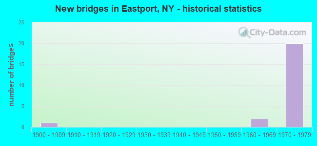
- New bridges - historical statistics
- 11900-1909
- 21960-1969
- 201970-1979


- Bridge Condition - Deck
- 46.2%Good
- 53.8%Satisfactory

- Bridge Condition - Superstructure
- 30.8%Good
- 53.8%Satisfactory
- 7.7%Fair
- 7.7%Poor

- Bridge Condition - Substructure
- 23.1%Good
- 69.2%Satisfactory
- 7.7%Fair
Find on map >> Show street view
Structure Number: 1019401, Location: EXIT 61 OF S.H.27 (Lat: 40.834369, Lng: -72.746728), Route carried "on" structure: State highway 27, Year Built: 1963, Status: Open, Structure Length: 8.53m (27.99ft), Average Daily Traffic: 16,767 (year 2019), Truck Traffic: 7%, Average Future Daily Traffic: 19,944 (year 2040), Design Load: HS 20, Features Intersected: COUNTY ROAD 51, NB, COUN
Minimum Vertical Clearance: 30+ m (98+ ft), Kilometerpoint: 60.611, Lanes on structure: 2, Lanes under structure: 4, Base Highway Network: Yes, Owner: State Highway Agency, Approaching Roadway Width: 12.2m (40.0ft), Skew: 6 degrees, Material/Design: Steel, Design/Construction: Stringer/Multi-beam, Number Of Spans In Main Unit: 4, Length of Maximum Span: 26.2m (86.0ft), Curb-To-Curb Width: 12.2m (40.0ft), Out-to-Out Width: 14.0m (45.9ft)
Condition: Deck: Satisfactory, Superstructure: Satisfactory, Substructure: Good, Operating Rating: 47.3 metric tons, Method Used To Determine Operating Rating: Load and Resistance Factor Rating (LRFR) rating reported by rating factor(RF) method using HL-93 loadings, Inventory Rating: 36.6 metric tons, Method Used To Determine Inventory Rating: Load and Resistance Factor Rating (LRFR) rating reported by rating factor(RF) method using HL-93 loadings, Structural Evaluation: Equal to present minimum criteria, Deck Geometry: Better than present minimum criteria, Underclear: High priority of corrective action, Approach Roadway Alignment: Equal to present desirable criteria, Length Of Structure Improvement: 8.53m (27.99ft), Designated Inspection Frequency: Every 24 months, Inspection Date: August 2021, Bridge Improvement Cost: $4,929,000, Roadway Improvement Cost: $2,886,000, Total Project Cost: $7,815,000 ( Estimate for 2021), Deck Structure Type: Concrete Cast-file-Place, Wearing Surface/Protective System: Wearing Surface: Integral Concrete
Find on map >> Show street view
Structure Number: 105632, Location: 14.1 MI E SH 112 & SH 27 (Lat: 40.833386, Lng: -72.747642), Route carried "on" structure: Ramp State highway , Year Built: 1970, Status: Open, Structure Length: 11.16m (36.61ft), Average Daily Traffic: 6,926 (year 2018), Truck Traffic: 2%, Average Future Daily Traffic: 8,238 (year 2040), Design Load: HS 20, Features Intersected: COUNTY ROAD 51, NB, COUN, Facility Carried by Structure: 27COL-DST RD EB
Minimum Vertical Clearance: 30+ m (98+ ft), Kilometerpoint: 0.338, Lanes on structure: 2, Lanes under structure: 5, Owner: State Highway Agency, Approaching Roadway Width: 12.5m (41.0ft), Skew: 6 degrees, Material/Design: Steel, Design/Construction: Stringer/Multi-beam, Number Of Spans In Main Unit: 4, Length of Maximum Span: 38.4m (126.0ft), Curb-To-Curb Width: 12.5m (41.0ft), Out-to-Out Width: 13.4m (44.0ft)
Condition: Deck: Satisfactory, Superstructure: Satisfactory, Substructure: Satisfactory, Operating Rating: 66.2 metric tons, Method Used To Determine Operating Rating: Load Factor (LF), Inventory Rating: 39.0 metric tons, Method Used To Determine Inventory Rating: Load Factor (LF), Structural Evaluation: Equal to present minimum criteria, Deck Geometry: Superior to present desirable criteria, Underclear: Meets minimum limits, Approach Roadway Alignment: Better than present minimum criteria, Length Of Structure Improvement: 11.15m (36.58ft), Designated Inspection Frequency: Every 24 months, Inspection Date: August 2021, Bridge Improvement Cost: $5,865,000, Roadway Improvement Cost: $3,435,000, Total Project Cost: $9,300,000 ( Estimate for 2021), Deck Structure Type: Concrete Cast-file-Place, Wearing Surface/Protective System: Wearing Surface: Integral Concrete
Find on map >> Show street view
Structure Number: 1056331, Location: 14.4 MI E RTS 112+27 (Lat: 40.836144, Lng: -72.741647), Route carried "on" structure: State highway 27, Year Built: 1970, Status: Open, Structure Length: 3.47m (11.38ft), Average Daily Traffic: 11,184 (year 2019), Truck Traffic: 7%, Average Future Daily Traffic: 13,303 (year 2040), Design Load: HS 20, Features Intersected: County Road 55 , SB, COU
Minimum Vertical Clearance: 30+ m (98+ ft), Kilometerpoint: 61.158, Lanes on structure: 2, Lanes under structure: 4, Base Highway Network: Yes, Owner: State Highway Agency, Approaching Roadway Width: 16.2m (53.1ft), Material/Design: Steel, Design/Construction: Stringer/Multi-beam, Number Of Spans In Main Unit: 1, Length of Maximum Span: 33.5m (109.9ft), Curb-To-Curb Width: 16.2m (53.1ft), Out-to-Out Width: 17.1m (56.1ft)
Condition: Deck: Satisfactory, Superstructure: Fair, Substructure: Good, Operating Rating: 65.3 metric tons, Method Used To Determine Operating Rating: Load Factor (LF), Inventory Rating: 32.7 metric tons, Method Used To Determine Inventory Rating: Load Factor (LF), Structural Evaluation: Somewhat better than minimum adequacy, Deck Geometry: Superior to present desirable criteria, Underclear: Equal to present minimum criteria, Approach Roadway Alignment: Better than present minimum criteria, Length Of Structure Improvement: 3.47m (11.38ft), Designated Inspection Frequency: Every 24 months, Inspection Date: July 2021, Bridge Improvement Cost: $3,465,000, Roadway Improvement Cost: $2,029,000, Total Project Cost: $5,493,000 ( Estimate for 2021), Deck Structure Type: Concrete Cast-file-Place, Wearing Surface/Protective System: Wearing Surface: Integral Concrete
Find on map >> Show street view
Structure Number: 1056332, Location: 14.4 MI E RTS 112+27 (Lat: 40.835878, Lng: -72.741644), Route carried "on" structure: State highway 27, Year Built: 1970, Status: Open, Structure Length: 3.47m (11.38ft), Average Daily Traffic: 11,184 (year 2019), Truck Traffic: 7%, Average Future Daily Traffic: 13,303 (year 2040), Design Load: HS 20, Features Intersected: COUNTY ROAD 55
Minimum Vertical Clearance: 30+ m (98+ ft), Kilometerpoint: 61.158, Lanes on structure: 2, Lanes under structure: 6, Base Highway Network: Yes, Owner: State Highway Agency, Approaching Roadway Width: 16.2m (53.1ft), Material/Design: Steel, Design/Construction: Stringer/Multi-beam, Number Of Spans In Main Unit: 1, Length of Maximum Span: 33.5m (109.9ft), Curb-To-Curb Width: 16.2m (53.1ft), Out-to-Out Width: 17.1m (56.1ft)
Condition: Deck: Good, Superstructure: Good, Substructure: Satisfactory, Operating Rating: 65.3 metric tons, Method Used To Determine Operating Rating: Load Factor (LF), Inventory Rating: 32.7 metric tons, Method Used To Determine Inventory Rating: Load Factor (LF), Structural Evaluation: Equal to present minimum criteria, Deck Geometry: Superior to present desirable criteria, Underclear: Better than present minimum criteria, Approach Roadway Alignment: Better than present minimum criteria, Length Of Structure Improvement: 3.47m (11.38ft), Designated Inspection Frequency: Every 24 months, Inspection Date: July 2021, Bridge Improvement Cost: $3,465,000, Roadway Improvement Cost: $2,029,000, Total Project Cost: $5,493,000 ( Estimate for 2021), Deck Structure Type: Concrete Cast-file-Place, Wearing Surface/Protective System: Wearing Surface: Integral Concrete
Find on map >> Show street view
Structure Number: 1056341, Location: EXIT 62 - SUNRISE HWY (Lat: 40.844097, Lng: -72.723939), Route carried "on" structure: State highway 27, Year Built: 1970, Status: Open, Structure Length: 5.85m (19.19ft), Average Daily Traffic: 17,866 (year 2018), Truck Traffic: 7%, Average Future Daily Traffic: 21,251 (year 2040), Design Load: HS 20, Features Intersected: COUNTY ROAD 111, COUNTY
Minimum Vertical Clearance: 30+ m (98+ ft), Kilometerpoint: 62.896, Lanes on structure: 2, Lanes under structure: 4, Base Highway Network: Yes, Owner: State Highway Agency, Approaching Roadway Width: 15.2m (49.9ft), Skew: 3 degrees, Material/Design: Steel, Design/Construction: Stringer/Multi-beam, Number Of Spans In Main Unit: 2, Length of Maximum Span: 28.3m (92.8ft), Curb-To-Curb Width: 16.2m (53.1ft), Out-to-Out Width: 17.1m (56.1ft)
Condition: Deck: Good, Superstructure: Good, Substructure: Satisfactory, Operating Rating: 54.8 metric tons, Method Used To Determine Operating Rating: Load and Resistance Factor Rating (LRFR) rating reported by rating factor(RF) method using HL-93 loadings, Inventory Rating: 42.4 metric tons, Method Used To Determine Inventory Rating: Load and Resistance Factor Rating (LRFR) rating reported by rating factor(RF) method using HL-93 loadings, Structural Evaluation: Equal to present minimum criteria, Deck Geometry: Superior to present desirable criteria, Underclear: Somewhat better than minimum adequacy, Approach Roadway Alignment: Better than present minimum criteria, Length Of Structure Improvement: 5.85m (19.19ft), Designated Inspection Frequency: Every 24 months, Inspection Date: May 2020, Bridge Improvement Cost: $5,282,000, Roadway Improvement Cost: $3,093,000, Total Project Cost: $8,375,000 ( Estimate for 2021), Deck Structure Type: Concrete Cast-file-Place, Wearing Surface/Protective System: Wearing Surface: Integral Concrete
Find on map >> Show street view
Structure Number: 1056342, Location: EXIT 62 - SUNRISE HWY (Lat: 40.843814, Lng: -72.723767), Route carried "on" structure: State highway 27, Year Built: 1970, Status: Open, Structure Length: 5.85m (19.19ft), Average Daily Traffic: 17,866 (year 2018), Truck Traffic: 7%, Average Future Daily Traffic: 21,251 (year 2040), Design Load: HS 20, Features Intersected: COUNTY ROAD 111, COUNTY
Minimum Vertical Clearance: 30+ m (98+ ft), Kilometerpoint: 62.896, Lanes on structure: 2, Lanes under structure: 4, Base Highway Network: Yes, Owner: State Highway Agency, Approaching Roadway Width: 15.2m (49.9ft), Skew: 3 degrees, Material/Design: Steel, Design/Construction: Stringer/Multi-beam, Number Of Spans In Main Unit: 2, Length of Maximum Span: 28.3m (92.8ft), Curb-To-Curb Width: 16.2m (53.1ft), Out-to-Out Width: 17.1m (56.1ft)
Condition: Deck: Good, Superstructure: Good, Substructure: Satisfactory, Operating Rating: 54.8 metric tons, Method Used To Determine Operating Rating: Load and Resistance Factor Rating (LRFR) rating reported by rating factor(RF) method using HL-93 loadings, Inventory Rating: 42.4 metric tons, Method Used To Determine Inventory Rating: Load and Resistance Factor Rating (LRFR) rating reported by rating factor(RF) method using HL-93 loadings, Structural Evaluation: Equal to present minimum criteria, Deck Geometry: Superior to present desirable criteria, Underclear: Equal to present minimum criteria, Approach Roadway Alignment: Better than present minimum criteria, Length Of Structure Improvement: 5.85m (19.19ft), Designated Inspection Frequency: Every 24 months, Inspection Date: May 2020, Bridge Improvement Cost: $5,282,000, Roadway Improvement Cost: $3,093,000, Total Project Cost: $8,375,000 ( Estimate for 2021), Deck Structure Type: Concrete Cast-file-Place, Wearing Surface/Protective System: Wearing Surface: Integral Concrete
Find on map >> Show street view
Structure Number: 105635, Location: 17 MI E RTS 112+27 (Lat: 40.852622, Lng: -72.696828), Route carried "on" structure: Other road , Year Built: 1970, Status: Open, Structure Length: 6.46m (21.19ft), Average Daily Traffic: 2,140 (year 2020), Truck Traffic: 13%, Average Future Daily Traffic: 2,599 (year 2040), Design Load: HS 20, Features Intersected: 27 27 07051408, RTE 27, Facility Carried by Structure: SPEONK-RIVERHD RD
Minimum Vertical Clearance: 30+ m (98+ ft), Kilometerpoint: 2.719, Lanes on structure: 2, Lanes under structure: 4, Owner: State Highway Agency, Approaching Roadway Width: 11.6m (38.1ft), Skew: 1 degrees, Material/Design: Steel, Design/Construction: Stringer/Multi-beam, Number Of Spans In Main Unit: 2, Length of Maximum Span: 31.6m (103.7ft), Curb or Sidewalk Widths: Left: 1.5m (4.9ft), Right: 0.0m, Curb-To-Curb Width: 11.4m (37.4ft), Out-to-Out Width: 13.7m (44.9ft)
Condition: Deck: Good, Superstructure: Good, Substructure: Good, Operating Rating: 88.9 metric tons, Method Used To Determine Operating Rating: Load Factor (LF), Inventory Rating: 52.6 metric tons, Method Used To Determine Inventory Rating: Load Factor (LF), Structural Evaluation: Better than present minimum criteria, Deck Geometry: Somewhat better than minimum adequacy, Underclear: Somewhat better than minimum adequacy, Approach Roadway Alignment: Better than present minimum criteria, Length Of Structure Improvement: 6.46m (21.19ft), Designated Inspection Frequency: Every 24 months, Inspection Date: July 2021, Bridge Improvement Cost: $4,129,000, Roadway Improvement Cost: $2,418,000, Total Project Cost: $6,547,000 ( Estimate for 2021), Deck Structure Type: Concrete Cast-file-Place, Wearing Surface/Protective System: Wearing Surface: Integral Concrete
Find on map >> Show street view
Structure Number: 105652, Location: EXIT 61 OF SH 27 (Lat: 40.834967, Lng: -72.746178), Route carried "on" structure: Ramp State highway , Year Built: 1970, Status: Open, Structure Length: 10.27m (33.69ft), Average Daily Traffic: 3,958 (year 2018), Truck Traffic: 2%, Average Future Daily Traffic: 4,708 (year 2040), Design Load: HS 20, Features Intersected: COUNTY ROAD 51, NB, COUN, Facility Carried by Structure: 27 SERVICE RD WB
Minimum Vertical Clearance: 30+ m (98+ ft), Kilometerpoint: 0.354, Lanes on structure: 1, Lanes under structure: 4, Owner: State Highway Agency, Approaching Roadway Width: 12.5m (41.0ft), Skew: 6 degrees, Material/Design: Steel, Design/Construction: Stringer/Multi-beam, Number Of Spans In Main Unit: 4, Length of Maximum Span: 31.3m (102.7ft), Curb-To-Curb Width: 12.5m (41.0ft), Out-to-Out Width: 13.4m (44.0ft)
Condition: Deck: Satisfactory, Superstructure: Satisfactory, Substructure: Satisfactory, Operating Rating: 77.1 metric tons, Method Used To Determine Operating Rating: Load Factor (LF), Inventory Rating: 46.3 metric tons, Method Used To Determine Inventory Rating: Load Factor (LF), Structural Evaluation: Equal to present minimum criteria, Deck Geometry: Superior to present desirable criteria, Underclear: High priority of corrective action, Approach Roadway Alignment: Better than present minimum criteria, Length Of Structure Improvement: 10.27m (33.69ft), Designated Inspection Frequency: Every 24 months, Inspection Date: August 2021, Bridge Improvement Cost: $5,458,000, Roadway Improvement Cost: $3,196,000, Total Project Cost: $8,654,000 ( Estimate for 2021), Deck Structure Type: Concrete Cast-file-Place, Wearing Surface/Protective System: Wearing Surface: Integral Concrete
Find on map >> Show street view
Structure Number: 226114, Location: .5 MILE EAST OF EASTPORT (Lat: 40.824100, Lng: -72.724492), Route carried "on" structure: Other road , Year Built: 1907, Year Reconstructed: 1990, Status: Posted for load, Structure Length: 3.02m (9.91ft), Average Daily Traffic: 289 (year 2017), Truck Traffic: 1%, Average Future Daily Traffic: 405 (year 2037), Design Load: Pedestrian, Features Intersected: LONG ISLAND-MK BR, Facility Carried by Structure: RIVER AVENUE
Minimum Vertical Clearance: 30+ m (98+ ft), Kilometerpoint: 0.145, Lanes on structure: 2, Owner: Town or Township Highway Agency, Approaching Roadway Width: 5.8m (19.0ft), Material/Design: Steel, Design/Construction: Girder and Floorbeam System, Number Of Spans In Main Unit: 3, Length of Maximum Span: 10.7m (35.1ft), Curb or Sidewalk Widths: Left: 1.2m (3.9ft), Right: 0.0m, Curb-To-Curb Width: 5.7m (18.7ft), Out-to-Out Width: 7.7m (25.3ft)
Condition: Deck: Satisfactory, Superstructure: Poor, Substructure: Fair, Operating Rating: 5.4 metric tons, Method Used To Determine Operating Rating: Load Factor (LF), Inventory Rating: 3.6 metric tons, Method Used To Determine Inventory Rating: Load Factor (LF), Structural Evaluation: High priority of corrective action, Deck Geometry: High priority of corrective action, Underclear: Meets minimum limits, Approach Roadway Alignment: Meets minimum limits, Bridge Posting: Required (Relationship of Operating Rating to Maximum Legal Load: > 39.9% below), Length Of Structure Improvement: 3.01m (9.88ft), Designated Inspection Frequency: Every 12 months, Critical Feature Inspection Frequency: Every 12 months, Inspection Date: November 2021, Critical Feature Inspection Date: November 2021, Bridge Improvement Cost: $1,380,000, Roadway Improvement Cost: $808,000, Total Project Cost: $2,187,000 ( Estimate for 2021), Deck Structure Type: Wood or Timber, Wearing Surface/Protective System: Wearing Surface: Wood or Timber
Find on map >> Show street view
Structure Number: 3364411, Location: 1 MI N OF EASTPORT (Lat: 40.848358, Lng: -72.740136), Route carried "on" structure: County highway , Year Built: 1974, Status: Open, Structure Length: 4.79m (15.72ft), Average Daily Traffic: 12,265 (year 2020), Truck Traffic: 7%, Average Future Daily Traffic: 14,588 (year 2040), Design Load: HS 20, Features Intersected: TOPPINGS PATH ROW, Facility Carried by Structure: PORT JEFFERSON RD
Minimum Vertical Clearance: 30+ m (98+ ft), Kilometerpoint: 1.657, Lanes on structure: 2, Owner: County Highway Agency, Approaching Roadway Width: 11.6m (38.1ft), Skew: 1 degrees, Material/Design: Steel, Design/Construction: Stringer/Multi-beam, Number Of Spans In Main Unit: 3, Length of Maximum Span: 22.5m (73.8ft), Curb or Sidewalk Widths: Left: 0.4m (1.3ft), Right: 0.4m (1.3ft), Curb-To-Curb Width: 11.6m (38.1ft), Out-to-Out Width: 13.1m (43.0ft)
Condition: Deck: Good, Superstructure: Satisfactory, Substructure: Satisfactory, Operating Rating: 88.0 metric tons, Method Used To Determine Operating Rating: Load Factor (LF), Inventory Rating: 52.6 metric tons, Method Used To Determine Inventory Rating: Load Factor (LF), Structural Evaluation: Equal to present minimum criteria, Deck Geometry: Equal to present minimum criteria, Approach Roadway Alignment: Equal to present desirable criteria, Length Of Structure Improvement: 4.78m (15.68ft), Designated Inspection Frequency: Every 24 months, Inspection Date: May 2020, Bridge Improvement Cost: $2,440,000, Roadway Improvement Cost: $1,429,000, Total Project Cost: $3,868,000 ( Estimate for 2021), Deck Structure Type: Concrete Cast-file-Place, Wearing Surface/Protective System: Wearing Surface: Monolithic Concrete
Find on map >> Show street view
Structure Number: 3364412, Location: 1 MI N OF EASTPORT (Lat: 40.848581, Lng: -72.740122), Route carried "on" structure: County highway , Year Built: 1974, Status: Open, Structure Length: 4.66m (15.29ft), Average Daily Traffic: 12,265 (year 2020), Truck Traffic: 7%, Average Future Daily Traffic: 14,588 (year 2040), Design Load: HS 20, Features Intersected: TOPPINGS PATH ROW, Facility Carried by Structure: PORT JEFFERSON RD
Minimum Vertical Clearance: 30+ m (98+ ft), Kilometerpoint: 1.657, Lanes on structure: 2, Owner: County Highway Agency, Approaching Roadway Width: 11.6m (38.1ft), Skew: 1 degrees, Material/Design: Steel, Design/Construction: Stringer/Multi-beam, Number Of Spans In Main Unit: 3, Length of Maximum Span: 22.5m (73.8ft), Curb or Sidewalk Widths: Left: 0.4m (1.3ft), Right: 0.4m (1.3ft), Curb-To-Curb Width: 11.6m (38.1ft), Out-to-Out Width: 13.1m (43.0ft)
Condition: Deck: Good, Superstructure: Satisfactory, Substructure: Satisfactory, Operating Rating: 86.2 metric tons, Method Used To Determine Operating Rating: Load Factor (LF), Inventory Rating: 51.7 metric tons, Method Used To Determine Inventory Rating: Load Factor (LF), Structural Evaluation: Equal to present minimum criteria, Deck Geometry: Equal to present minimum criteria, Approach Roadway Alignment: Equal to present desirable criteria, Length Of Structure Improvement: 4.66m (15.29ft), Designated Inspection Frequency: Every 24 months, Inspection Date: May 2020, Bridge Improvement Cost: $2,385,000, Roadway Improvement Cost: $1,397,000, Total Project Cost: $3,781,000 ( Estimate for 2021), Deck Structure Type: Concrete Cast-file-Place, Wearing Surface/Protective System: Wearing Surface: Monolithic Concrete
Find on map >> Show street view
Structure Number: 3364421, Location: 1 MI N OF EASTPORT (Lat: 40.846667, Lng: -72.735356), Route carried "on" structure: County highway , Year Built: 1974, Status: Open, Structure Length: 6.83m (22.41ft), Average Daily Traffic: 12,265 (year 2020), Truck Traffic: 7%, Average Future Daily Traffic: 14,588 (year 2040), Design Load: HS 20, Features Intersected: EAST MORICHES RD (EB Dir, Facility Carried by Structure: PORT JEFFERSON RD
Minimum Vertical Clearance: 30+ m (98+ ft), Kilometerpoint: 1.239, Lanes on structure: 2, Lanes under structure: 5, Owner: County Highway Agency, Approaching Roadway Width: 11.6m (38.1ft), Material/Design: Steel, Design/Construction: Stringer/Multi-beam, Number Of Spans In Main Unit: 4, Length of Maximum Span: 22.5m (73.8ft), Curb or Sidewalk Widths: Left: 0.4m (1.3ft), Right: 0.4m (1.3ft), Curb-To-Curb Width: 11.6m (38.1ft), Out-to-Out Width: 13.1m (43.0ft)
Condition: Deck: Satisfactory, Superstructure: Satisfactory, Substructure: Satisfactory, Operating Rating: 77.1 metric tons, Method Used To Determine Operating Rating: Load Factor (LF), Inventory Rating: 46.3 metric tons, Method Used To Determine Inventory Rating: Load Factor (LF), Structural Evaluation: Equal to present minimum criteria, Deck Geometry: Equal to present minimum criteria, Underclear: Equal to present minimum criteria, Approach Roadway Alignment: Equal to present desirable criteria, Length Of Structure Improvement: 6.82m (22.38ft), Designated Inspection Frequency: Every 24 months, Inspection Date: April 2020, Bridge Improvement Cost: $3,348,000, Roadway Improvement Cost: $1,961,000, Total Project Cost: $5,309,000 ( Estimate for 2021), Deck Structure Type: Concrete Cast-file-Place, Wearing Surface/Protective System: Wearing Surface: Integral Concrete
Find on map >> Show street view
Structure Number: 3364422, Location: 1 MI N OF EASTPORT (Lat: 40.846839, Lng: -72.735208), Route carried "on" structure: County highway , Year Built: 1974, Status: Open, Structure Length: 6.83m (22.41ft), Average Daily Traffic: 12,265 (year 2020), Truck Traffic: 7%, Average Future Daily Traffic: 14,588 (year 2040), Design Load: HS 20, Features Intersected: EAST MORICHES RD, EAST M, Facility Carried by Structure: Port Jefferson Rd.
Minimum Vertical Clearance: 30+ m (98+ ft), Kilometerpoint: 1.239, Lanes on structure: 2, Lanes under structure: 5, Owner: County Highway Agency, Approaching Roadway Width: 11.6m (38.1ft), Material/Design: Steel, Design/Construction: Stringer/Multi-beam, Number Of Spans In Main Unit: 4, Length of Maximum Span: 22.5m (73.8ft), Curb or Sidewalk Widths: Left: 0.4m (1.3ft), Right: 0.4m (1.3ft), Curb-To-Curb Width: 11.6m (38.1ft), Out-to-Out Width: 13.1m (43.0ft)
Condition: Deck: Satisfactory, Superstructure: Satisfactory, Substructure: Satisfactory, Operating Rating: 50.5 metric tons, Method Used To Determine Operating Rating: Load and Resistance Factor Rating (LRFR) rating reported by rating factor(RF) method using HL-93 loadings, Inventory Rating: 38.9 metric tons, Method Used To Determine Inventory Rating: Load and Resistance Factor Rating (LRFR) rating reported by rating factor(RF) method using HL-93 loadings, Structural Evaluation: Equal to present minimum criteria, Deck Geometry: Equal to present minimum criteria, Underclear: Somewhat better than minimum adequacy, Approach Roadway Alignment: Equal to present desirable criteria, Length Of Structure Improvement: 6.82m (22.38ft), Designated Inspection Frequency: Every 24 months, Inspection Date: April 2020, Bridge Improvement Cost: $3,348,000, Roadway Improvement Cost: $1,961,000, Total Project Cost: $5,309,000 ( Estimate for 2021), Deck Structure Type: Concrete Cast-file-Place, Wearing Surface/Protective System: Wearing Surface: Integral Concrete
Find on map >> Show street view
Structure Number: 1019401, Location: EXIT 61 OF S.H.27 (Lat: 40.834369, Lng: -72.746728), Route carried "under" structure: Alternate County highway , Year Built: 1963, Structure Length: 0. m, Average Daily Traffic: 3,000 (year 2021), Features Intersected: COUNTY ROAD 51, NB, COUN, Facility Carried by Structure: RTE 27
Minimum Vertical Clearance: 4.29m (14.07ft), Kilometerpoint: 0.000, Lanes on structure: 2, Lanes under structure: 2, Material/Design: Steel, Design/Construction: Stringer/Multi-beam, Length of Maximum Span: 26.2m (86.0ft)
Find on map >> Show street view
Structure Number: 105632, Location: 14.1 MI E SH 112 & SH 27 (Lat: 40.833386, Lng: -72.747642), Route carried "under" structure: County highway , Year Built: 1970, Structure Length: 0. m, Average Daily Traffic: 11,412 (year 2004), Features Intersected: COUNTY ROAD 51, NB, COUN, Facility Carried by Structure: 27COL-DST RD EB
Minimum Vertical Clearance: 4.55m (14.93ft), Kilometerpoint: 0.000, Lanes on structure: 2, Lanes under structure: 2, Material/Design: Steel, Design/Construction: Stringer/Multi-beam, Length of Maximum Span: 38.4m (126.0ft)
Find on map >> Show street view
Structure Number: 1056331, Location: 14.4 MI E RTS 112+27 (Lat: 40.836144, Lng: -72.741647), Route carried "under" structure: County highway , Year Built: 1970, Structure Length: 0. m, Average Daily Traffic: 12,433 (year 2003), Features Intersected: County Road 55 , SB, COU, Facility Carried by Structure: RTE 27
Minimum Vertical Clearance: 4.65m (15.26ft), Kilometerpoint: 0.000, Lanes on structure: 2, Lanes under structure: 2, Material/Design: Steel, Design/Construction: Stringer/Multi-beam, Length of Maximum Span: 33.5m (109.9ft)
Find on map >> Show street view
Structure Number: 1056332, Location: 14.4 MI E RTS 112+27 (Lat: 40.835878, Lng: -72.741644), Route carried "under" structure: County highway , Year Built: 1970, Structure Length: 0. m, Average Daily Traffic: 12,433 (year 2003), Features Intersected: COUNTY ROAD 55, Facility Carried by Structure: RTE 27
Minimum Vertical Clearance: 4.88m (16.01ft), Kilometerpoint: 0.000, Lanes on structure: 2, Lanes under structure: 6, Material/Design: Steel, Design/Construction: Stringer/Multi-beam, Length of Maximum Span: 33.5m (109.9ft)
Find on map >> Show street view
Structure Number: 1056341, Location: EXIT 62 - SUNRISE HWY (Lat: 40.844097, Lng: -72.723939), Route carried "under" structure: Alternate County highway , Year Built: 1970, Structure Length: 0. m, Average Daily Traffic: 16,301 (year 2005), Features Intersected: COUNTY ROAD 111, COUNTY, Facility Carried by Structure: RTE 27
Minimum Vertical Clearance: 4.39m (14.40ft), Kilometerpoint: 0.000, Lanes on structure: 2, Lanes under structure: 2, Material/Design: Steel, Design/Construction: Stringer/Multi-beam, Length of Maximum Span: 28.3m (92.8ft)
Find on map >> Show street view
Structure Number: 1056342, Location: EXIT 62 - SUNRISE HWY (Lat: 40.843814, Lng: -72.723767), Route carried "under" structure: Alternate County highway , Year Built: 1970, Structure Length: 0. m, Average Daily Traffic: 16,301 (year 2005), Features Intersected: COUNTY ROAD 111, COUNTY, Facility Carried by Structure: RTE 27
Minimum Vertical Clearance: 4.72m (15.49ft), Kilometerpoint: 0.000, Lanes on structure: 2, Lanes under structure: 2, Material/Design: Steel, Design/Construction: Stringer/Multi-beam, Length of Maximum Span: 28.3m (92.8ft)
Find on map >> Show street view
Structure Number: 105635, Location: 17 MI E RTS 112+27 (Lat: 40.852622, Lng: -72.696828), Route carried "under" structure: State highway 27, Year Built: 1970, Structure Length: 0. m, Average Daily Traffic: 15,200 (year 1969), Features Intersected: 27 27 07051408, RTE 27, Facility Carried by Structure: SPEONK-RIVERHD RD
Minimum Vertical Clearance: 4.70m (15.42ft), Kilometerpoint: 65.647, Lanes on structure: 2, Lanes under structure: 2, Material/Design: Steel, Design/Construction: Stringer/Multi-beam, Length of Maximum Span: 31.6m (103.7ft)
Find on map >> Show street view
Structure Number: 105652, Location: EXIT 61 OF SH 27 (Lat: 40.834967, Lng: -72.746178), Route carried "under" structure: County highway , Year Built: 1970, Structure Length: 0. m, Average Daily Traffic: 11,412 (year 2004), Features Intersected: COUNTY ROAD 51, NB, COUN, Facility Carried by Structure: 27 SERVICE RD WB
Minimum Vertical Clearance: 4.45m (14.60ft), Kilometerpoint: 0.000, Lanes on structure: 1, Lanes under structure: 2, Material/Design: Steel, Design/Construction: Stringer/Multi-beam, Length of Maximum Span: 31.3m (102.7ft)
Find on map >> Show street view
Structure Number: 3364421, Location: 1 MI N OF EASTPORT (Lat: 40.846667, Lng: -72.735356), Route carried "under" structure: County highway , Year Built: 1974, Structure Length: 0. m, Average Daily Traffic: 10,434 (year 2004), Features Intersected: EAST MORICHES RD (EB Dir, Facility Carried by Structure: PORT JEFFERSON RD
Minimum Vertical Clearance: 4.67m (15.32ft), Kilometerpoint: 0.000, Lanes on structure: 2, Lanes under structure: 2, Material/Design: Steel, Design/Construction: Stringer/Multi-beam, Length of Maximum Span: 22.5m (73.8ft)
Find on map >> Show street view
Structure Number: 3364422, Location: 1 MI N OF EASTPORT (Lat: 40.846839, Lng: -72.735208), Route carried "under" structure: County highway , Year Built: 1974, Structure Length: 0. m, Average Daily Traffic: 10,434 (year 2004), Features Intersected: EAST MORICHES RD, EAST M, Facility Carried by Structure: Port Jefferson Rd.
Minimum Vertical Clearance: 4.45m (14.60ft), Kilometerpoint: 0.000, Lanes on structure: 2, Lanes under structure: 2, Material/Design: Steel, Design/Construction: Stringer/Multi-beam, Length of Maximum Span: 22.5m (73.8ft)