Bridge Statistics for Ebensburg, Pennsylvania (PA)
Condition, Traffic, Stress, Structural Evaluation, Project Costs
- National Bridge Inventory (NBI) Statistics
- 21Number of bridges
- 112ft / 34.3mTotal length
- $4,840,000Total costs
- 123,206Total average daily traffic
- 19,769Total average daily truck traffic
- National Bridge Inventory (NBI) Registered Bridges for Ebensburg
- No street view available for this location
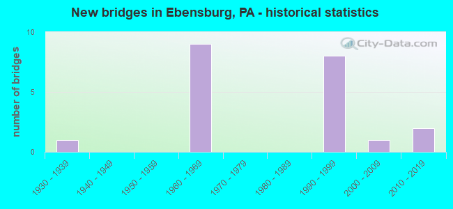
- New bridges - historical statistics
- 11930-1939
- 91960-1969
- 81990-1999
- 12000-2009
- 22010-2019

- Reconstructed bridges - Historical Statistics
- 32000-2009
- 42010-2019


- Bridge Condition - Deck
- 25.0%Very good
- 50.0%Good
- 16.7%Satisfactory
- 8.3%Fair

- Bridge Condition - Superstructure
- 33.3%Very good
- 50.0%Good
- 8.3%Satisfactory
- 8.3%Fair

- Bridge Condition - Substructure
- 25.0%Very good
- 66.7%Good
- 8.3%Satisfactory

- Bridge Condition - Channel
- 60.0%Good
- 40.0%Satisfactory
Find on map >> Show street view
Structure Number: 8343, Location: 1.3 MILE EAST OF US 219 (Lat: 40.474683, Lng: -78.743306), Route carried "on" structure: US 22, Year Built: 1960, Year Reconstructed: 2010, Status: Open, Structure Length: 1.77m (5.81ft), Average Daily Traffic: 20,330 (year 2022), Truck Traffic: 21%, Average Future Daily Traffic: 22,530 (year 2032), Design Load: HS 20, Features Intersected: SR 8004
Minimum Vertical Clearance: 30+ m (98+ ft), Kilometerpoint: 17.817, Lanes on structure: 2, Lanes under structure: 2, Base Highway Network: Yes, Owner: State Highway Agency, Approaching Roadway Width: 12.8m (42.0ft), Skew: 33 degrees, Material/Design: Prestressed concrete, Design/Construction: Box Beam or Girders - Multiple, Number Of Spans In Main Unit: 1, Length of Maximum Span: 16.8m (55.1ft), Curb or Sidewalk Widths: Left: 0.2m (0.7ft), Right: 0.2m (0.7ft), Curb-To-Curb Width: 12.7m (41.7ft), Out-to-Out Width: 27.3m (89.6ft)
Condition: Deck: Fair, Superstructure: Fair, Substructure: Good, Operating Rating: 84.4 metric tons, Method Used To Determine Operating Rating: Load Factor (LF), Inventory Rating: 41.7 metric tons, Method Used To Determine Inventory Rating: Load Factor (LF), Structural Evaluation: Somewhat better than minimum adequacy, Deck Geometry: Somewhat better than minimum adequacy, Underclear: Somewhat better than minimum adequacy, Approach Roadway Alignment: Equal to present desirable criteria, Length Of Structure Improvement: 2.20m (7.22ft), Designated Inspection Frequency: Every 24 months, Inspection Date: August 2020, Bridge Improvement Cost: $240,000, Roadway Improvement Cost: $707,000, Total Project Cost: $3,241,000, Deck Structure Type: Concrete Cast-file-Place, Wearing Surface/Protective System: Wearing Surface: Epoxy Overlay, Deck Protection: Epoxy Coated Reinforcing
Find on map >> Show street view
Structure Number: 8344, Location: OVER PA 160 (Lat: 40.475344, Lng: -78.738842), Route carried "on" structure: US 22, Year Built: 1960, Year Reconstructed: 2010, Status: Open, Structure Length: 1.55m (5.09ft), Average Daily Traffic: 20,330 (year 2022), Truck Traffic: 21%, Average Future Daily Traffic: 22,530 (year 2032), Design Load: HS 25 or greater, Features Intersected: PA 160
Minimum Vertical Clearance: 30+ m (98+ ft), Kilometerpoint: 18.905, Lanes on structure: 2, Lanes under structure: 2, Base Highway Network: Yes, Owner: State Highway Agency, Approaching Roadway Width: 12.8m (42.0ft), Skew: 34 degrees, Material/Design: Prestressed concrete, Design/Construction: Box Beam or Girders - Single/Spread, Number Of Spans In Main Unit: 1, Length of Maximum Span: 14.6m (47.9ft), Curb or Sidewalk Widths: Left: 0.2m (0.7ft), Right: 0.2m (0.7ft), Curb-To-Curb Width: 12.7m (41.7ft), Out-to-Out Width: 27.3m (89.6ft)
Condition: Deck: Good, Superstructure: Good, Substructure: Good, Operating Rating: 68.0 metric tons, Method Used To Determine Operating Rating: Load Factor (LF), Inventory Rating: 40.8 metric tons, Method Used To Determine Inventory Rating: Load Factor (LF), Structural Evaluation: Better than present minimum criteria, Deck Geometry: Somewhat better than minimum adequacy, Underclear: Meets minimum limits, Approach Roadway Alignment: Equal to present desirable criteria, Length Of Structure Improvement: 2.20m (7.22ft), Designated Inspection Frequency: Every 48 months, Inspection Date: August 2020, Deck Structure Type: Concrete Cast-file-Place, Wearing Surface/Protective System: Wearing Surface: Epoxy Overlay, Deck Protection: Epoxy Coated Reinforcing
Find on map >> Show street view
Structure Number: 8345, Location: 0.2 MILE EAST OF SR 2013 (Lat: 40.478031, Lng: -78.720436), Route carried "on" structure: US 22, Year Built: 1960, Year Reconstructed: 2009, Status: Open, Structure Length: 1.46m (4.79ft), Average Daily Traffic: 18,984 (year 2022), Truck Traffic: 18%, Average Future Daily Traffic: 21,168 (year 2040), Design Load: HS 20, Features Intersected: HOWELLS RUN
Minimum Vertical Clearance: 30+ m (98+ ft), Kilometerpoint: 19.951, Lanes on structure: 2, Base Highway Network: Yes, Owner: State Highway Agency, Approaching Roadway Width: 25.6m (84.0ft), Skew: 34 degrees, Material/Design: Concrete, Design/Construction: Tee Beam, Number Of Spans In Main Unit: 1, Length of Maximum Span: 13.7m (44.9ft), Curb or Sidewalk Widths: Left: 0.2m (0.7ft), Right: 0.2m (0.7ft), Curb-To-Curb Width: 25.4m (83.3ft), Out-to-Out Width: 27.2m (89.2ft)
Condition: Deck: Satisfactory, Superstructure: Satisfactory, Substructure: Good, Channel: Satisfactory, Operating Rating: 50.8 metric tons, Method Used To Determine Operating Rating: Load Factor (LF), Inventory Rating: 30.8 metric tons, Method Used To Determine Inventory Rating: Load Factor (LF), Structural Evaluation: Equal to present minimum criteria, Deck Geometry: Superior to present desirable criteria, Waterway Adequacy: Equal to present minimum criteria, Approach Roadway Alignment: Equal to present desirable criteria, Length Of Structure Improvement: 2.10m (6.89ft), Designated Inspection Frequency: Every 24 months, Inspection Date: June 2021, Deck Structure Type: Concrete Cast-file-Place, Wearing Surface/Protective System: Wearing Surface: Latex Concrete
Find on map >> Show street view
Structure Number: 8481, Location: 0.9 MILE NORTH OF TR 422 (Lat: 40.499861, Lng: -78.741519), Route carried "on" structure: US 219, Year Built: 1990, Year Reconstructed: 2018, Status: Open, Structure Length: 3.51m (11.52ft), Average Daily Traffic: 2,794 (year 2020), Truck Traffic: 19%, Average Future Daily Traffic: 3,140 (year 2032), Design Load: HS 25 or greater, Features Intersected: SR 4005
Minimum Vertical Clearance: 30+ m (98+ ft), Kilometerpoint: 33.566, Lanes on structure: 2, Lanes under structure: 2, Base Highway Network: Yes, Owner: State Highway Agency, Approaching Roadway Width: 11.6m (38.1ft), Skew: 14 degrees, Material/Design: Prestressed concrete, Design/Construction: Stringer/Multi-beam, Number Of Spans In Main Unit: 1, Length of Maximum Span: 32.9m (107.9ft), Curb or Sidewalk Widths: Left: 0.2m (0.7ft), Right: 0.2m (0.7ft), Curb-To-Curb Width: 12.2m (40.0ft), Out-to-Out Width: 13.0m (42.7ft)
Condition: Deck: Good, Superstructure: Good, Substructure: Good, Inventory Rating: 46.3 metric tons, Method Used To Determine Inventory Rating: Load Factor (LF), Structural Evaluation: Better than present minimum criteria, Deck Geometry: Better than present minimum criteria, Underclear: Somewhat better than minimum adequacy, Approach Roadway Alignment: Equal to present desirable criteria, Length Of Structure Improvement: 4.40m (14.44ft), Designated Inspection Frequency: Every 48 months, Inspection Date: July 2021, Deck Structure Type: Concrete Cast-file-Place, Wearing Surface/Protective System: Wearing Surface: Latex Concrete, Deck Protection: Epoxy Coated Reinforcing
Find on map >> Show street view
Structure Number: 8482, Location: 0.9 MILE NORTH OF TR 422 (Lat: 40.500297, Lng: -78.741783), Route carried "on" structure: US 219, Year Built: 1990, Year Reconstructed: 2018, Status: Open, Structure Length: 3.72m (12.20ft), Average Daily Traffic: 2,902 (year 2020), Truck Traffic: 26%, Average Future Daily Traffic: 2,952 (year 2032), Design Load: HS 25 or greater, Features Intersected: SR 4005
Minimum Vertical Clearance: 30+ m (98+ ft), Kilometerpoint: 33.584, Lanes on structure: 2, Lanes under structure: 2, Base Highway Network: Yes, Owner: State Highway Agency, Approaching Roadway Width: 11.6m (38.1ft), Skew: 15 degrees, Material/Design: Prestressed concrete, Design/Construction: Stringer/Multi-beam, Number Of Spans In Main Unit: 1, Length of Maximum Span: 34.7m (113.8ft), Curb or Sidewalk Widths: Left: 0.2m (0.7ft), Right: 0.2m (0.7ft), Curb-To-Curb Width: 12.2m (40.0ft), Out-to-Out Width: 13.0m (42.7ft)
Condition: Deck: Good, Superstructure: Good, Substructure: Good, Inventory Rating: 46.3 metric tons, Method Used To Determine Inventory Rating: Load Factor (LF), Structural Evaluation: Better than present minimum criteria, Deck Geometry: Better than present minimum criteria, Underclear: Meets minimum limits, Approach Roadway Alignment: Equal to present desirable criteria, Length Of Structure Improvement: 4.70m (15.42ft), Designated Inspection Frequency: Every 48 months, Inspection Date: July 2021, Deck Structure Type: Concrete Cast-file-Place, Wearing Surface/Protective System: Wearing Surface: Latex Concrete, Deck Protection: Epoxy Coated Reinforcing
Find on map >> Show street view
Structure Number: 8547, Location: 3 MI.N.OF EBENSBURG (Lat: 40.530378, Lng: -78.735025), Route carried "on" structure: State highway , Year Built: 1990, Status: Open, Structure Length: 6.55m (21.49ft), Average Daily Traffic: 276 (year 2022), Truck Traffic: 9%, Average Future Daily Traffic: 153 (year 2032), Design Load: HS 25 or greater, Features Intersected: US 0219, Facility Carried by Structure: SR 1002
Minimum Vertical Clearance: 30+ m (98+ ft), Kilometerpoint: 0.892, Lanes on structure: 2, Lanes under structure: 4, Owner: State Highway Agency, Approaching Roadway Width: 8.5m (27.9ft), Skew: 1 degrees, Material/Design: Prestressed concrete, Design/Construction: Stringer/Multi-beam, Number Of Spans In Main Unit: 2, Length of Maximum Span: 32.0m (105.0ft), Curb or Sidewalk Widths: Left: 0.2m (0.7ft), Right: 0.2m (0.7ft), Curb-To-Curb Width: 8.5m (27.9ft), Out-to-Out Width: 9.3m (30.5ft)
Condition: Deck: Good, Superstructure: Good, Substructure: Good, Operating Rating: 75.3 metric tons, Method Used To Determine Operating Rating: Load Factor (LF), Inventory Rating: 45.4 metric tons, Method Used To Determine Inventory Rating: Load Factor (LF), Structural Evaluation: Better than present minimum criteria, Deck Geometry: Equal to present minimum criteria, Underclear: Better than present minimum criteria, Approach Roadway Alignment: Equal to present desirable criteria, Length Of Structure Improvement: 7.50m (24.61ft), Designated Inspection Frequency: Every 48 months, Inspection Date: October 2019, Deck Structure Type: Concrete Cast-file-Place, Wearing Surface/Protective System: Wearing Surface: Monolithic Concrete, Deck Protection: Epoxy Coated Reinforcing
Find on map >> Show street view
Structure Number: 8602, Location: 2.5 MI.S.OF EBENSBURG (Lat: 40.446253, Lng: -78.715247), Route carried "on" structure: State highway , Year Built: 1992, Status: Open, Structure Length: 2.13m (6.99ft), Average Daily Traffic: 340 (year 2020), Truck Traffic: 2%, Average Future Daily Traffic: 488 (year 2032), Design Load: HS 25 or greater, Features Intersected: HOWELLS RUN, Facility Carried by Structure: SR 2013
Minimum Vertical Clearance: 30+ m (98+ ft), Kilometerpoint: 2.519, Lanes on structure: 2, Owner: State Highway Agency, Approaching Roadway Width: 8.8m (28.9ft), Skew: 3 degrees, Material/Design: Prestressed concrete, Design/Construction: Box Beam or Girders - Single/Spread, Number Of Spans In Main Unit: 1, Length of Maximum Span: 21.0m (68.9ft), Curb or Sidewalk Widths: Left: 0.2m (0.7ft), Right: 0.2m (0.7ft), Curb-To-Curb Width: 9.8m (32.2ft), Out-to-Out Width: 10.8m (35.4ft)
Condition: Deck: Good, Superstructure: Good, Substructure: Good, Channel: Good, Operating Rating: 82.6 metric tons, Method Used To Determine Operating Rating: Load Factor (LF), Inventory Rating: 46.3 metric tons, Method Used To Determine Inventory Rating: Load Factor (LF), Structural Evaluation: Better than present minimum criteria, Deck Geometry: Better than present minimum criteria, Waterway Adequacy: Superior to present desirable criteria, Approach Roadway Alignment: Equal to present desirable criteria, Length Of Structure Improvement: 2.80m (9.19ft), Designated Inspection Frequency: Every 24 months, Inspection Date: May 2021, Deck Structure Type: Concrete Cast-file-Place, Wearing Surface/Protective System: Wearing Surface: Monolithic Concrete, Deck Protection: Epoxy Coated Reinforcing
Find on map >> Show street view
Structure Number: 8603, Location: .5 MI.S.OF EBENSBURG (Lat: 40.473056, Lng: -78.724897), Route carried "on" structure: State highway , Year Built: 1937, Year Reconstructed: 2013, Status: Open, Structure Length: 1.40m (4.59ft), Average Daily Traffic: 340 (year 2020), Truck Traffic: 2%, Average Future Daily Traffic: 488 (year 2032), Design Load: HL 93, Features Intersected: HOWELLS RUN, Facility Carried by Structure: SR 2013
Minimum Vertical Clearance: 30+ m (98+ ft), Kilometerpoint: 5.832, Lanes on structure: 2, Owner: State Highway Agency, Approaching Roadway Width: 7.3m (24.0ft), Skew: 4 degrees, Material/Design: Steel, Design/Construction: Stringer/Multi-beam, Number Of Spans In Main Unit: 1, Length of Maximum Span: 13.1m (43.0ft), Curb-To-Curb Width: 7.3m (24.0ft), Out-to-Out Width: 7.9m (25.9ft)
Condition: Deck: Very good, Superstructure: Very good, Substructure: Very good, Channel: Satisfactory, Operating Rating: 47.0 metric tons, Method Used To Determine Operating Rating: Assigned ratings based on Load and Resistance Factor Design (LRFD) reported by rating factor (RF) using HL93 loadings, Inventory Rating: 36.3 metric tons, Method Used To Determine Inventory Rating: Assigned ratings based on Load and Resistance Factor Design (LRFD) reported by rating factor (RF) using HL93 loadings, Structural Evaluation: Equal to present desirable criteria, Deck Geometry: Somewhat better than minimum adequacy, Waterway Adequacy: Better than present minimum criteria, Approach Roadway Alignment: Equal to present desirable criteria, Length Of Structure Improvement: 1.70m (5.58ft), Designated Inspection Frequency: Every 48 months, Inspection Date: Febuary 2019, Bridge Improvement Cost: $56,000, Roadway Improvement Cost: $264,000, Total Project Cost: $750,000, Deck Structure Type: Concrete Cast-file-Place, Wearing Surface/Protective System: Wearing Surface: Monolithic Concrete, Deck Protection: Galvanized Reinforcing
Find on map >> Show street view
Structure Number: 8604, Location: OVER SR 22 AT SR 8006 (Lat: 40.480708, Lng: -78.708303), Route carried "on" structure: State highway , Year Built: 1960, Year Reconstructed: 2007, Status: Open, Structure Length: 6.25m (20.51ft), Average Daily Traffic: 4,752 (year 2022), Truck Traffic: 15%, Average Future Daily Traffic: 1,310 (year 2032), Design Load: HS 20, Features Intersected: US 22, Facility Carried by Structure: SR 2014
Minimum Vertical Clearance: 30+ m (98+ ft), Kilometerpoint: 0.000, Lanes on structure: 2, Lanes under structure: 5, Owner: State Highway Agency, Approaching Roadway Width: 18.3m (60.0ft), Skew: 24 degrees, Material/Design: Steel, Design/Construction: Stringer/Multi-beam, Number Of Spans In Main Unit: 1, Number Of Approach Spans: 2, Length of Maximum Span: 39.6m (129.9ft), Curb or Sidewalk Widths: Left: 0.2m (0.7ft), Right: 0.2m (0.7ft), Curb-To-Curb Width: 18.3m (60.0ft), Out-to-Out Width: 19.4m (63.6ft)
Condition: Deck: Satisfactory, Superstructure: Good, Substructure: Satisfactory, Operating Rating: 69.9 metric tons, Method Used To Determine Operating Rating: Load Factor (LF), Inventory Rating: 41.7 metric tons, Method Used To Determine Inventory Rating: Load Factor (LF), Structural Evaluation: Equal to present minimum criteria, Deck Geometry: Superior to present desirable criteria, Underclear: High priority of corrective action, Approach Roadway Alignment: Equal to present desirable criteria, Length Of Structure Improvement: 7.20m (23.62ft), Designated Inspection Frequency: Every 24 months, Inspection Date: March 2021, Bridge Improvement Cost: $63,000, Roadway Improvement Cost: $185,000, Total Project Cost: $849,000, Deck Structure Type: Concrete Cast-file-Place, Wearing Surface/Protective System: Wearing Surface: Latex Concrete, Deck Protection: Epoxy Coated Reinforcing
Find on map >> Show street view
Structure Number: 45635, Location: 0.15 MILE WEST FROM US 22 (Lat: 40.486306, Lng: -78.708906), Route carried "on" structure: State highway , Year Built: 2009, Status: Open, Structure Length: 2.44m (8.01ft), Average Daily Traffic: 8,558 (year 2020), Truck Traffic: 7%, Average Future Daily Traffic: 9,789 (year 2032), Design Load: HL 93, Features Intersected: HOWELLS RUN @LAKE ROWENA, Facility Carried by Structure: SR 1036
Minimum Vertical Clearance: 30+ m (98+ ft), Kilometerpoint: 2.466, Lanes on structure: 2, Base Highway Network: Yes, Owner: State Highway Agency, Approaching Roadway Width: 10.1m (33.1ft), Skew: 3 degrees, Material/Design: Steel, Design/Construction: Stringer/Multi-beam, Number Of Spans In Main Unit: 1, Length of Maximum Span: 22.9m (75.1ft), Curb or Sidewalk Widths: Left: 1.5m (4.9ft), Right: 1.5m (4.9ft), Curb-To-Curb Width: 10.7m (35.1ft), Out-to-Out Width: 14.3m (46.9ft)
Condition: Deck: Good, Superstructure: Very good, Substructure: Very good, Channel: Good, Operating Rating: 69.9 metric tons, Method Used To Determine Operating Rating: Load and Resistance Factor (LRFR), Inventory Rating: 53.5 metric tons, Method Used To Determine Inventory Rating: Load and Resistance Factor (LRFR), Structural Evaluation: Equal to present desirable criteria, Deck Geometry: Meets minimum limits, Waterway Adequacy: Superior to present desirable criteria, Approach Roadway Alignment: Equal to present desirable criteria, Designated Inspection Frequency: Every 48 months, Inspection Date: October 2019, Deck Structure Type: Concrete Cast-file-Place, Wearing Surface/Protective System: Wearing Surface: Monolithic Concrete, Deck Protection: Epoxy Coated Reinforcing
Find on map >> Show street view
Structure Number: 52767, Location: EBENSBURG BORO LINE (Lat: 40.481697, Lng: -78.735411), Route carried "on" structure: State highway , Year Built: 2015, Status: Open, Structure Length: 1.95m (6.40ft), Average Daily Traffic: 9,595 (year 2021), Truck Traffic: 2%, Average Future Daily Traffic: 17,407 (year 2035), Design Load: HL 93, Features Intersected: GHOST TOWN TRAIL, Facility Carried by Structure: SR 4031 (OLD 219)
Minimum Vertical Clearance: 30+ m (98+ ft), Kilometerpoint: 0.826, Lanes on structure: 3, Owner: State Highway Agency, Approaching Roadway Width: 11.6m (38.1ft), Skew: 4 degrees, Material/Design: Prestressed concrete, Design/Construction: Box Beam or Girders - Single/Spread, Number Of Spans In Main Unit: 1, Length of Maximum Span: 18.9m (62.0ft), Curb or Sidewalk Widths: Left: 1.7m (5.6ft), Right: 1.7m (5.6ft), Curb-To-Curb Width: 11.6m (38.1ft), Out-to-Out Width: 15.7m (51.5ft)
Condition: Deck: Very good, Superstructure: Very good, Substructure: Very good, Operating Rating: 45.0 metric tons, Method Used To Determine Operating Rating: Assigned ratings based on Load and Resistance Factor Design (LRFD) reported by rating factor (RF) using HL93 loadings, Inventory Rating: 35.0 metric tons, Method Used To Determine Inventory Rating: Assigned ratings based on Load and Resistance Factor Design (LRFD) reported by rating factor (RF) using HL93 loadings, Structural Evaluation: Equal to present desirable criteria, Deck Geometry: High priority of replacement, Underclear: High priority of corrective action, Approach Roadway Alignment: Equal to present desirable criteria, Designated Inspection Frequency: Every 48 months, Inspection Date: May 2019, Deck Structure Type: Concrete Cast-file-Place, Wearing Surface/Protective System: Wearing Surface: Monolithic Concrete, Deck Protection: Epoxy Coated Reinforcing
Find on map >> Show street view
Structure Number: 54801, Location: 1.1 mile south of SR 2014 (Lat: 40.449836, Lng: -78.686572), Route carried "on" structure: City street , Year Built: 2017, Status: Open, Structure Length: 1.55m (5.09ft), Average Daily Traffic: 26 (year 2020), Truck Traffic: 1%, Average Future Daily Traffic: 27 (year 2040), Design Load: HL 93, Features Intersected: N.Br.Little Conemaugh R, Facility Carried by Structure: T-407, Spinner Rd
Minimum Vertical Clearance: 30+ m (98+ ft), Kilometerpoint: 0.000, Lanes on structure: 2, Owner: Town or Township Highway Agency, Approaching Roadway Width: 6.7m (22.0ft), Skew: 3 degrees, Material/Design: Prestressed concrete, Design/Construction: Box Beam or Girders - Single/Spread, Number Of Spans In Main Unit: 1, Length of Maximum Span: 14.0m (45.9ft), Curb or Sidewalk Widths: Left: 0.5m (1.6ft), Right: 0.5m (1.6ft), Curb-To-Curb Width: 7.1m (23.3ft), Out-to-Out Width: 8.2m (26.9ft)
Condition: Deck: Very good, Superstructure: Very good, Substructure: Good, Channel: Good, Operating Rating: 57.3 metric tons, Method Used To Determine Operating Rating: Assigned ratings based on Load and Resistance Factor Design (LRFD) reported by rating factor (RF) using HL93 loadings, Inventory Rating: 41.1 metric tons, Method Used To Determine Inventory Rating: Assigned ratings based on Load and Resistance Factor Design (LRFD) reported by rating factor (RF) using HL93 loadings, Structural Evaluation: Better than present minimum criteria, Deck Geometry: Somewhat better than minimum adequacy, Waterway Adequacy: Better than present minimum criteria, Approach Roadway Alignment: Equal to present desirable criteria, Designated Inspection Frequency: Every 24 months, Inspection Date: January 2020, Deck Structure Type: Concrete Cast-file-Place, Wearing Surface/Protective System: Wearing Surface: Monolithic Concrete, Deck Protection: Epoxy Coated Reinforcing
Find on map >> Show street view
Structure Number: 8343, Location: 1.3 MILE EAST OF US 219 (Lat: 40.474683, Lng: -78.743306), Route carried "under" structure: Ramp State highway , Year Built: 1960, Structure Length: 0. m, Average Daily Traffic: 2,023 (year 2022), Truck Traffic: 7%, Features Intersected: SR 8004, Facility Carried by Structure: US 22
Minimum Vertical Clearance: 4.57m (14.99ft), Kilometerpoint: 0.000, Lanes on structure: 2, Lanes under structure: 1, Material/Design: Prestressed concrete, Design/Construction: Box Beam or Girders - Multiple, Length of Maximum Span: 16.8m (55.1ft)
Find on map >> Show street view
Structure Number: 8343, Location: 1.3 MILE EAST OF US 219 (Lat: 40.474683, Lng: -78.743306), Route carried "under" structure: Ramp State highway , Year Built: 1960, Structure Length: 0. m, Average Daily Traffic: 153 (year 2022), Truck Traffic: 7%, Features Intersected: SR 8004, Facility Carried by Structure: US 22
Minimum Vertical Clearance: 4.67m (15.32ft), Kilometerpoint: 0.000, Lanes on structure: 2, Lanes under structure: 1, Material/Design: Prestressed concrete, Design/Construction: Box Beam or Girders - Multiple, Length of Maximum Span: 16.8m (55.1ft)
Find on map >> Show street view
Structure Number: 8344, Location: OVER PA 160 (Lat: 40.475344, Lng: -78.738842), Route carried "under" structure: State highway 160, Year Built: 1960, Structure Length: 0. m, Average Daily Traffic: 3,999 (year 2020), Truck Traffic: 2%, Features Intersected: PA 160, Facility Carried by Structure: US 22
Minimum Vertical Clearance: 4.55m (14.93ft), Kilometerpoint: 35.341, Lanes on structure: 2, Lanes under structure: 2, Material/Design: Prestressed concrete, Design/Construction: Box Beam or Girders - Single/Spread, Length of Maximum Span: 14.6m (47.9ft)
Find on map >> Show street view
Structure Number: 8481, Location: 0.9 MILE NORTH OF TR 422 (Lat: 40.499861, Lng: -78.741519), Route carried "under" structure: State highway , Year Built: 1990, Structure Length: 0. m, Average Daily Traffic: 1,562 (year 2020), Truck Traffic: 2%, Features Intersected: SR 4005, Facility Carried by Structure: US 219 NBL
Minimum Vertical Clearance: 6.10m (20.01ft), Kilometerpoint: 2.248, Lanes on structure: 2, Lanes under structure: 2, Material/Design: Prestressed concrete, Design/Construction: Stringer/Multi-beam, Length of Maximum Span: 32.9m (107.9ft)
Find on map >> Show street view
Structure Number: 8482, Location: 0.9 MILE NORTH OF TR 422 (Lat: 40.500297, Lng: -78.741783), Route carried "under" structure: State highway , Year Built: 1990, Structure Length: 0. m, Average Daily Traffic: 1,562 (year 2020), Truck Traffic: 2%, Features Intersected: SR 4005, Facility Carried by Structure: US 219 SBL
Minimum Vertical Clearance: 4.47m (14.67ft), Kilometerpoint: 2.248, Lanes on structure: 2, Lanes under structure: 2, Material/Design: Prestressed concrete, Design/Construction: Stringer/Multi-beam, Length of Maximum Span: 34.7m (113.8ft)
Find on map >> Show street view
Structure Number: 8547, Location: 3 MI.N.OF EBENSBURG (Lat: 40.530378, Lng: -78.735025), Route carried "under" structure: US 219, Year Built: 1990, Structure Length: 0. m, Average Daily Traffic: 2,794 (year 2020), Truck Traffic: 19%, Features Intersected: US 0219, Facility Carried by Structure: SR 1002
Minimum Vertical Clearance: 5.33m (17.49ft), Kilometerpoint: 37.068, Lanes on structure: 2, Lanes under structure: 2, Material/Design: Prestressed concrete, Design/Construction: Stringer/Multi-beam, Length of Maximum Span: 32.0m (105.0ft)
Find on map >> Show street view
Structure Number: 8547, Location: 3 MI.N.OF EBENSBURG (Lat: 40.530378, Lng: -78.735025), Route carried "under" structure: US 219, Year Built: 1990, Structure Length: 0. m, Average Daily Traffic: 2,902 (year 2020), Truck Traffic: 26%, Features Intersected: US 0219, Facility Carried by Structure: SR 1002
Minimum Vertical Clearance: 5.46m (17.91ft), Kilometerpoint: 37.063, Lanes on structure: 2, Lanes under structure: 2, Material/Design: Prestressed concrete, Design/Construction: Stringer/Multi-beam, Length of Maximum Span: 32.0m (105.0ft)
Find on map >> Show street view
Structure Number: 8604, Location: OVER SR 22 AT SR 8006 (Lat: 40.480708, Lng: -78.708303), Route carried "under" structure: US 22, Year Built: 1960, Structure Length: 0. m, Average Daily Traffic: 9,679 (year 2022), Truck Traffic: 18%, Features Intersected: US 22, Facility Carried by Structure: SR 2014
Minimum Vertical Clearance: 5.00m (16.40ft), Kilometerpoint: 21.729, Lanes on structure: 2, Lanes under structure: 3, Material/Design: Steel, Design/Construction: Stringer/Multi-beam, Length of Maximum Span: 39.6m (129.9ft)
Find on map >> Show street view
Structure Number: 8604, Location: OVER SR 22 AT SR 8006 (Lat: 40.480708, Lng: -78.708303), Route carried "under" structure: US 22, Year Built: 1960, Structure Length: 0. m, Average Daily Traffic: 9,305 (year 2022), Truck Traffic: 18%, Features Intersected: US 22, Facility Carried by Structure: SR 2014
Minimum Vertical Clearance: 4.62m (15.16ft), Kilometerpoint: 21.707, Lanes on structure: 2, Lanes under structure: 2, Material/Design: Steel, Design/Construction: Stringer/Multi-beam, Length of Maximum Span: 39.6m (129.9ft)