Bridge Statistics for Edgewood, Illinois (IL)
Condition, Traffic, Stress, Structural Evaluation, Project Costs
- National Bridge Inventory (NBI) Statistics
- 20Number of bridges
- 194ft / 59.3mTotal length
- 105,800Total average daily traffic
- 52,010Total average daily truck traffic
- National Bridge Inventory (NBI) Registered Bridges for Edgewood
- No street view available for this location
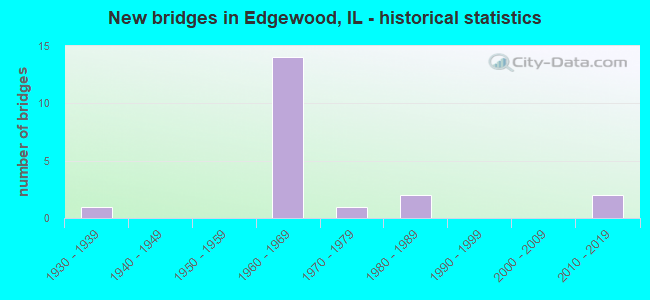
- New bridges - historical statistics
- 11930-1939
- 141960-1969
- 11970-1979
- 21980-1989
- 22010-2019


- Bridge Condition - Deck
- 7.7%Excellent
- 7.7%Very good
- 46.2%Good
- 38.5%Satisfactory

- Bridge Condition - Superstructure
- 7.7%Excellent
- 15.4%Very good
- 23.1%Good
- 53.8%Satisfactory

- Bridge Condition - Substructure
- 7.7%Excellent
- 15.4%Very good
- 23.1%Good
- 38.5%Satisfactory
- 15.4%Fair

- Bridge Condition - Channel
- 12.5%Excellent
- 12.5%Very good
- 12.5%Good
- 50.0%Satisfactory
- 12.5%Fair
Find on map >> Show street view
Structure Number: 130027, Location: EFF-CLAY CO LINE (Lat: 38.914297, Lng: -88.689514), Route carried "on" structure: County highway , Year Built: 1968, Year Reconstructed: 1996, Status: Open, Structure Length: 7.92m (25.98ft), Average Daily Traffic: 50 (year 2021), Truck Traffic: 8%, Average Future Daily Traffic: 51 (year 2032), Design Load: HS 15, Features Intersected: FAI-57, Facility Carried by Structure: TR-1
Minimum Vertical Clearance: 30+ m (98+ ft), Kilometerpoint: 0.322, Lanes on structure: 2, Lanes under structure: 4, Owner: State Highway Agency, Approaching Roadway Width: 4.9m (16.1ft), Skew: 3 degrees, Material/Design: Steel continuous, Design/Construction: Stringer/Multi-beam, Number Of Spans In Main Unit: 4, Length of Maximum Span: 24.7m (81.0ft), Curb-To-Curb Width: 8.1m (26.6ft), Out-to-Out Width: 9.2m (30.2ft)
Condition: Deck: Good, Superstructure: Good, Substructure: Fair, Operating Rating: 53.8 metric tons, Method Used To Determine Operating Rating: Load Factor (LF) rating reported by rating factor (RF) method using MS18 loading, Inventory Rating: 32.4 metric tons, Method Used To Determine Inventory Rating: Load Factor (LF) rating reported by rating factor (RF) method using MS18 loading, Structural Evaluation: Somewhat better than minimum adequacy, Deck Geometry: Equal to present minimum criteria, Underclear: High priority of corrective action, Approach Roadway Alignment: Equal to present minimum criteria, Designated Inspection Frequency: Every 24 months, Inspection Date: November 2021, Deck Structure Type: Concrete Cast-file-Place
Find on map >> Show street view
Structure Number: 250067, Location: 1 MI N CLAY CO LINE (Lat: 38.926050, Lng: -88.672119), Route carried "on" structure: Interstate 57, Year Built: 1969, Status: Open, Structure Length: 6.83m (22.41ft), Average Daily Traffic: 10,350 (year 2021), Truck Traffic: 49%, Average Future Daily Traffic: 7,979 (year 2032), Design Load: HS 20+Mod, Features Intersected: CH-27 & RR ABANDONED
Minimum Vertical Clearance: 30+ m (98+ ft), Kilometerpoint: 231.659, Lanes on structure: 2, Lanes under structure: 2, Base Highway Network: Yes, Owner: State Highway Agency, Approaching Roadway Width: 12.2m (40.0ft), Material/Design: Steel continuous, Design/Construction: Stringer/Multi-beam, Number Of Spans In Main Unit: 4, Length of Maximum Span: 18.3m (60.0ft), Curb-To-Curb Width: 12.2m (40.0ft), Out-to-Out Width: 12.8m (42.0ft)
Condition: Deck: Satisfactory, Superstructure: Satisfactory, Substructure: Satisfactory, Operating Rating: 56.7 metric tons, Method Used To Determine Operating Rating: Load Factor (LF) rating reported by rating factor (RF) method using MS18 loading, Inventory Rating: 34.0 metric tons, Method Used To Determine Inventory Rating: Load Factor (LF) rating reported by rating factor (RF) method using MS18 loading, Structural Evaluation: Equal to present minimum criteria, Deck Geometry: Better than present minimum criteria, Underclear: Superior to present desirable criteria, Approach Roadway Alignment: Equal to present desirable criteria, Designated Inspection Frequency: Every 24 months, Inspection Date: December 2021, Deck Structure Type: Concrete Cast-file-Place, Wearing Surface/Protective System: Wearing Surface: Other
Find on map >> Show street view
Structure Number: 250068, Location: 1 MI N CLAY CO LN (Lat: 38.926136, Lng: -88.672011), Route carried "on" structure: Interstate 57, Year Built: 1969, Status: Open, Structure Length: 6.83m (22.41ft), Average Daily Traffic: 10,350 (year 2021), Truck Traffic: 49%, Average Future Daily Traffic: 7,979 (year 2032), Design Load: HS 20+Mod, Features Intersected: CH-27 & RR ABANDONED
Minimum Vertical Clearance: 30+ m (98+ ft), Kilometerpoint: 231.675, Lanes on structure: 2, Lanes under structure: 2, Base Highway Network: Yes, Owner: State Highway Agency, Approaching Roadway Width: 12.8m (42.0ft), Material/Design: Steel continuous, Design/Construction: Stringer/Multi-beam, Number Of Spans In Main Unit: 4, Length of Maximum Span: 18.3m (60.0ft), Curb-To-Curb Width: 12.2m (40.0ft), Out-to-Out Width: 12.8m (42.0ft)
Condition: Deck: Satisfactory, Superstructure: Satisfactory, Substructure: Satisfactory, Operating Rating: 56.4 metric tons, Method Used To Determine Operating Rating: Load Factor (LF) rating reported by rating factor (RF) method using MS18 loading, Inventory Rating: 33.7 metric tons, Method Used To Determine Inventory Rating: Load Factor (LF) rating reported by rating factor (RF) method using MS18 loading, Structural Evaluation: Equal to present minimum criteria, Deck Geometry: Better than present minimum criteria, Underclear: Superior to present desirable criteria, Approach Roadway Alignment: Equal to present desirable criteria, Designated Inspection Frequency: Every 24 months, Inspection Date: August 2020, Deck Structure Type: Concrete Cast-file-Place, Wearing Surface/Protective System: Wearing Surface: Other
Find on map >> Show street view
Structure Number: 250069, Location: EDGEWOOD INT (Lat: 38.933231, Lng: -88.663019), Route carried "on" structure: Interstate 57, Year Built: 1969, Status: Open, Structure Length: 4.82m (15.81ft), Average Daily Traffic: 9,900 (year 2021), Truck Traffic: 52%, Average Future Daily Traffic: 7,604 (year 2032), Design Load: HS 20+Mod, Features Intersected: FAS-2716
Minimum Vertical Clearance: 30+ m (98+ ft), Kilometerpoint: 232.785, Lanes on structure: 2, Lanes under structure: 2, Base Highway Network: Yes, Owner: State Highway Agency, Approaching Roadway Width: 12.2m (40.0ft), Skew: 3 degrees, Material/Design: Steel continuous, Design/Construction: Stringer/Multi-beam, Number Of Spans In Main Unit: 4, Length of Maximum Span: 12.5m (41.0ft), Curb-To-Curb Width: 12.2m (40.0ft), Out-to-Out Width: 12.7m (41.7ft)
Condition: Deck: Satisfactory, Superstructure: Satisfactory, Substructure: Satisfactory, Operating Rating: 62.9 metric tons, Method Used To Determine Operating Rating: Load Factor (LF) rating reported by rating factor (RF) method using MS18 loading, Inventory Rating: 37.9 metric tons, Method Used To Determine Inventory Rating: Load Factor (LF) rating reported by rating factor (RF) method using MS18 loading, Structural Evaluation: Equal to present minimum criteria, Deck Geometry: Better than present minimum criteria, Underclear: Meets minimum limits, Approach Roadway Alignment: Equal to present desirable criteria, Designated Inspection Frequency: Every 24 months, Inspection Date: December 2021, Deck Structure Type: Concrete Cast-file-Place, Wearing Surface/Protective System: Wearing Surface: Other
Find on map >> Show street view
Structure Number: 25007, Location: EDGEWOOD INT (Lat: 38.933350, Lng: -88.662861), Route carried "on" structure: Interstate 57, Year Built: 1969, Status: Open, Structure Length: 4.82m (15.81ft), Average Daily Traffic: 9,900 (year 2021), Truck Traffic: 52%, Average Future Daily Traffic: 7,604 (year 2032), Design Load: HS 20+Mod, Features Intersected: FAS-2716
Minimum Vertical Clearance: 30+ m (98+ ft), Kilometerpoint: 232.801, Lanes on structure: 2, Lanes under structure: 2, Base Highway Network: Yes, Owner: State Highway Agency, Approaching Roadway Width: 12.2m (40.0ft), Skew: 3 degrees, Material/Design: Steel continuous, Design/Construction: Stringer/Multi-beam, Number Of Spans In Main Unit: 4, Length of Maximum Span: 12.5m (41.0ft), Curb-To-Curb Width: 12.2m (40.0ft), Out-to-Out Width: 12.7m (41.7ft)
Condition: Deck: Satisfactory, Superstructure: Satisfactory, Substructure: Satisfactory, Operating Rating: 62.9 metric tons, Method Used To Determine Operating Rating: Load Factor (LF) rating reported by rating factor (RF) method using MS18 loading, Inventory Rating: 37.9 metric tons, Method Used To Determine Inventory Rating: Load Factor (LF) rating reported by rating factor (RF) method using MS18 loading, Structural Evaluation: Equal to present minimum criteria, Deck Geometry: Better than present minimum criteria, Underclear: Meets minimum limits, Approach Roadway Alignment: Equal to present desirable criteria, Designated Inspection Frequency: Every 24 months, Inspection Date: Febuary 2022, Deck Structure Type: Concrete Cast-file-Place, Wearing Surface/Protective System: Wearing Surface: Other
Find on map >> Show street view
Structure Number: 253, Location: 3 MI W MASON (Lat: 38.958903, Lng: -88.682294), Route carried "on" structure: County highway , Year Built: 1964, Status: Open, Structure Length: 3.11m (10.20ft), Average Daily Traffic: 450 (year 2018), Truck Traffic: 9%, Average Future Daily Traffic: 348 (year 2032), Design Load: HS 15, Features Intersected: LIMESTONE CREEK, Facility Carried by Structure: FAS-2715 (CH-12)
Minimum Vertical Clearance: 30+ m (98+ ft), Kilometerpoint: 5.761, Lanes on structure: 2, Owner: County Highway Agency, Approaching Roadway Width: 9.1m (29.9ft), Material/Design: Concrete, Design/Construction: Channel Beam, Number Of Spans In Main Unit: 3, Length of Maximum Span: 10.4m (34.1ft), Curb-To-Curb Width: 7.5m (24.6ft), Out-to-Out Width: 8.0m (26.2ft)
Condition: Deck: Good, Superstructure: Satisfactory, Substructure: Fair, Channel: Satisfactory, Operating Rating: 41.1 metric tons, Method Used To Determine Operating Rating: Load Factor (LF) rating reported by rating factor (RF) method using MS18 loading, Inventory Rating: 24.6 metric tons, Method Used To Determine Inventory Rating: Load Factor (LF) rating reported by rating factor (RF) method using MS18 loading, Structural Evaluation: Somewhat better than minimum adequacy, Deck Geometry: Meets minimum limits, Waterway Adequacy: Equal to present desirable criteria, Approach Roadway Alignment: Equal to present desirable criteria, Designated Inspection Frequency: Every 24 months, Inspection Date: November 2020, Deck Structure Type: Concrete Precast Panels, Wearing Surface/Protective System: Wearing Surface: Gravel
Find on map >> Show street view
Structure Number: 253322, Location: 1.5 MI NW EDGEWOOD (Lat: 38.951186, Lng: -88.694700), Route carried "on" structure: County highway , Year Built: 2012, Status: Open, Structure Length: 1.94m (6.36ft), Average Daily Traffic: 50 (year 2018), Truck Traffic: 8%, Average Future Daily Traffic: 54 (year 2032), Design Load: HS 25 or greater, Features Intersected: LIMESTONE CREEK, Facility Carried by Structure: TR 283
Minimum Vertical Clearance: 30+ m (98+ ft), Kilometerpoint: 1.464, Lanes on structure: 2, Owner: Town or Township Highway Agency, Approaching Roadway Width: 5.5m (18.0ft), Skew: 2 degrees, Material/Design: Prestressed concrete, Design/Construction: Box Beam or Girders - Multiple, Number Of Spans In Main Unit: 1, Length of Maximum Span: 18.3m (60.0ft), Curb-To-Curb Width: 7.3m (24.0ft), Out-to-Out Width: 7.3m (24.0ft)
Condition: Deck: Very good, Superstructure: Very good, Substructure: Very good, Channel: Very good, Operating Rating: 59.6 metric tons, Method Used To Determine Operating Rating: Load and Resistance Factor Rating (LRFR) rating reported by rating factor(RF) method using HL-93 loadings, Inventory Rating: 46.7 metric tons, Method Used To Determine Inventory Rating: Load and Resistance Factor Rating (LRFR) rating reported by rating factor(RF) method using HL-93 loadings, Structural Evaluation: Equal to present desirable criteria, Deck Geometry: Equal to present minimum criteria, Waterway Adequacy: Equal to present desirable criteria, Approach Roadway Alignment: Better than present minimum criteria, Designated Inspection Frequency: Every 48 months, Inspection Date: November 2018, Deck Structure Type: Concrete Precast Panels, Wearing Surface/Protective System: Wearing Surface: Gravel
Find on map >> Show street view
Structure Number: 253332, Location: 3.5 Mi. W. Edgewood (Lat: 38.937044, Lng: -88.730533), Route carried "on" structure: County highway , Year Built: 2019, Status: Open, Structure Length: 1.23m (4.04ft), Average Daily Traffic: 25 (year 2018), Truck Traffic: 4%, Average Future Daily Traffic: 80 (year 2032), Design Load: HS 25 or greater, Features Intersected: Fulfer Creek, Facility Carried by Structure: TR 34A
Minimum Vertical Clearance: 30+ m (98+ ft), Kilometerpoint: 12.408, Lanes on structure: 1, Owner: Town or Township Highway Agency, Approaching Roadway Width: 5.5m (18.0ft), Material/Design: Prestressed concrete, Design/Construction: Box Beam or Girders - Multiple, Number Of Spans In Main Unit: 1, Length of Maximum Span: 11.3m (37.1ft), Curb-To-Curb Width: 7.4m (24.3ft), Out-to-Out Width: 7.4m (24.3ft)
Condition: Deck: Excellent, Superstructure: Excellent, Substructure: Excellent, Channel: Excellent, Operating Rating: 60.6 metric tons, Method Used To Determine Operating Rating: Load and Resistance Factor Rating (LRFR) rating reported by rating factor(RF) method using HL-93 loadings, Inventory Rating: 46.7 metric tons, Method Used To Determine Inventory Rating: Load and Resistance Factor Rating (LRFR) rating reported by rating factor(RF) method using HL-93 loadings, Structural Evaluation: Superior to present desirable criteria, Deck Geometry: Equal to present minimum criteria, Waterway Adequacy: Equal to present desirable criteria, Approach Roadway Alignment: Equal to present desirable criteria, Designated Inspection Frequency: Every 24 months, Inspection Date: October 2020, Deck Structure Type: Concrete Precast Panels, Wearing Surface/Protective System: Wearing Surface: Gravel
Find on map >> Show street view
Structure Number: 255016, Location: 2.5 MI W MASON (Lat: 38.951533, Lng: -88.682375), Route carried "on" structure: County highway , Year Built: 1982, Status: Open, Structure Length: 0.79m (2.59ft), Average Daily Traffic: 50 (year 2018), Truck Traffic: 8%, Average Future Daily Traffic: 54 (year 2032), Design Load: HS 20, Features Intersected: LIMESTONE CREEK, Facility Carried by Structure: TR-283
Minimum Vertical Clearance: 30+ m (98+ ft), Kilometerpoint: 2.543, Lanes on structure: 2, Owner: Town or Township Highway Agency, Approaching Roadway Width: 6.7m (22.0ft), Material/Design: Concrete, Design/Construction: Culvert, Number Of Spans In Main Unit: 2, Length of Maximum Span: 3.9m (12.8ft), Curb-To-Curb Width: 7.3m (24.0ft), Out-to-Out Width: 7.6m (24.9ft)
Condition: Channel: Satisfactory, Culverts: Good, Operating Rating: 44.4 metric tons, Method Used To Determine Operating Rating: Load Factor (LF) rating reported by rating factor (RF) method using MS18 loading, Inventory Rating: 26.6 metric tons, Method Used To Determine Inventory Rating: Load Factor (LF) rating reported by rating factor (RF) method using MS18 loading, Structural Evaluation: Equal to present minimum criteria, Deck Geometry: Equal to present minimum criteria, Waterway Adequacy: Better than present minimum criteria, Approach Roadway Alignment: Equal to present minimum criteria, Designated Inspection Frequency: Every 24 months, Inspection Date: November 2020, Deck Structure Type: Concrete Cast-file-Place, Wearing Surface/Protective System: Wearing Surface: Gravel
Find on map >> Show street view
Structure Number: 260082, Location: 4.5 MI N FARINA INT (Lat: 38.892944, Lng: -88.722611), Route carried "on" structure: County highway , Year Built: 1968, Status: Open, Structure Length: 7.92m (25.98ft), Average Daily Traffic: 75 (year 2018), Truck Traffic: 3%, Average Future Daily Traffic: 52 (year 2032), Design Load: HS 15, Features Intersected: FAI-57, Facility Carried by Structure: TR-542
Minimum Vertical Clearance: 30+ m (98+ ft), Kilometerpoint: 1.110, Lanes on structure: 2, Lanes under structure: 4, Owner: State Highway Agency, Approaching Roadway Width: 5.5m (18.0ft), Skew: 3 degrees, Material/Design: Steel continuous, Design/Construction: Stringer/Multi-beam, Number Of Spans In Main Unit: 4, Length of Maximum Span: 24.7m (81.0ft), Curb-To-Curb Width: 8.1m (26.6ft), Out-to-Out Width: 9.2m (30.2ft)
Condition: Deck: Good, Superstructure: Good, Substructure: Good, Operating Rating: 38.9 metric tons, Method Used To Determine Operating Rating: Allowable Stress (AS) rating reported by rating factor (RF) method using MS18 loading, Inventory Rating: 24.3 metric tons, Method Used To Determine Inventory Rating: Allowable Stress (AS) rating reported by rating factor (RF) method using MS18 loading, Structural Evaluation: Equal to present minimum criteria, Deck Geometry: Equal to present minimum criteria, Underclear: Meets minimum limits, Approach Roadway Alignment: Better than present minimum criteria, Designated Inspection Frequency: Every 24 months, Inspection Date: April 2020, Deck Structure Type: Concrete Cast-file-Place
Find on map >> Show street view
Structure Number: 260083, Location: 5.5 MI N FARINA INT (Lat: 38.902639, Lng: -88.707656), Route carried "on" structure: Interstate 57, Year Built: 1969, Status: Open, Structure Length: 4.54m (14.90ft), Average Daily Traffic: 10,350 (year 2021), Truck Traffic: 51%, Average Future Daily Traffic: 7,674 (year 2032), Design Load: HS 20+Mod, Features Intersected: DISMAL CREEK
Minimum Vertical Clearance: 30+ m (98+ ft), Kilometerpoint: 227.668, Lanes on structure: 2, Base Highway Network: Yes, Owner: State Highway Agency, Approaching Roadway Width: 12.2m (40.0ft), Material/Design: Steel continuous, Design/Construction: Stringer/Multi-beam, Number Of Spans In Main Unit: 3, Length of Maximum Span: 16.2m (53.1ft), Curb-To-Curb Width: 11.9m (39.0ft), Out-to-Out Width: 13.0m (42.7ft)
Condition: Deck: Good, Superstructure: Good, Substructure: Good, Channel: Satisfactory, Operating Rating: 57.7 metric tons, Method Used To Determine Operating Rating: Load Factor (LF) rating reported by rating factor (RF) method using MS18 loading, Inventory Rating: 34.7 metric tons, Method Used To Determine Inventory Rating: Load Factor (LF) rating reported by rating factor (RF) method using MS18 loading, Structural Evaluation: Better than present minimum criteria, Deck Geometry: Equal to present minimum criteria, Waterway Adequacy: Equal to present desirable criteria, Approach Roadway Alignment: Equal to present desirable criteria, Designated Inspection Frequency: Every 24 months, Inspection Date: May 2020, Deck Structure Type: Concrete Cast-file-Place, Wearing Surface/Protective System: Wearing Surface: Other
Find on map >> Show street view
Structure Number: 260084, Location: 5.5 MI N FARINA INT (Lat: 38.902847, Lng: -88.707394), Route carried "on" structure: Interstate 57, Year Built: 1970, Status: Open, Structure Length: 4.54m (14.90ft), Average Daily Traffic: 10,350 (year 2021), Truck Traffic: 51%, Average Future Daily Traffic: 7,674 (year 2032), Design Load: HS 20+Mod, Features Intersected: DISMAL CREEK
Minimum Vertical Clearance: 30+ m (98+ ft), Kilometerpoint: 227.700, Lanes on structure: 2, Base Highway Network: Yes, Owner: State Highway Agency, Approaching Roadway Width: 12.2m (40.0ft), Material/Design: Steel continuous, Design/Construction: Stringer/Multi-beam, Number Of Spans In Main Unit: 3, Length of Maximum Span: 16.2m (53.1ft), Curb-To-Curb Width: 11.9m (39.0ft), Out-to-Out Width: 13.0m (42.7ft)
Condition: Deck: Good, Superstructure: Satisfactory, Substructure: Good, Channel: Satisfactory, Operating Rating: 59.9 metric tons, Method Used To Determine Operating Rating: Load Factor (LF) rating reported by rating factor (RF) method using MS18 loading, Inventory Rating: 35.0 metric tons, Method Used To Determine Inventory Rating: Load Factor (LF) rating reported by rating factor (RF) method using MS18 loading, Structural Evaluation: Equal to present minimum criteria, Deck Geometry: Equal to present minimum criteria, Waterway Adequacy: Equal to present desirable criteria, Approach Roadway Alignment: Equal to present desirable criteria, Designated Inspection Frequency: Every 24 months, Inspection Date: May 2020, Deck Structure Type: Concrete Cast-file-Place, Wearing Surface/Protective System: Wearing Surface: Other
Find on map >> Show street view
Structure Number: 26009, Location: .5 MI S CLAY CO LN (Lat: 38.892061, Lng: -88.700006), Route carried "on" structure: State highway 37, Year Built: 1985, Status: Open, Structure Length: 3.08m (10.10ft), Average Daily Traffic: 750 (year 2021), Truck Traffic: 13%, Average Future Daily Traffic: 979 (year 2032), Design Load: HS 20, Features Intersected: DISMAL CREEK
Minimum Vertical Clearance: 30+ m (98+ ft), Kilometerpoint: 227.571, Lanes on structure: 2, Owner: State Highway Agency, Approaching Roadway Width: 7.9m (25.9ft), Skew: 3 degrees, Material/Design: Prestressed concrete, Design/Construction: Stringer/Multi-beam, Number Of Spans In Main Unit: 1, Length of Maximum Span: 30.2m (99.1ft), Curb-To-Curb Width: 9.8m (32.2ft), Out-to-Out Width: 10.8m (35.4ft)
Condition: Deck: Good, Superstructure: Very good, Substructure: Very good, Channel: Good, Operating Rating: 81.0 metric tons, Method Used To Determine Operating Rating: Load Factor (LF) rating reported by rating factor (RF) method using MS18 loading, Inventory Rating: 32.4 metric tons, Method Used To Determine Inventory Rating: Load Factor (LF) rating reported by rating factor (RF) method using MS18 loading, Structural Evaluation: Equal to present desirable criteria, Deck Geometry: Equal to present minimum criteria, Waterway Adequacy: Better than present minimum criteria, Approach Roadway Alignment: Equal to present desirable criteria, Designated Inspection Frequency: Every 48 months, Inspection Date: August 2018, Deck Structure Type: Concrete Cast-file-Place, Wearing Surface/Protective System: Deck Protection: Epoxy Coated Reinforcing
Find on map >> Show street view
Structure Number: 263247, Location: W LA CLEDE (Lat: 38.879400, Lng: -88.717775), Route carried "on" structure: County highway , Year Built: 1930, Status: Open, Structure Length: 0.91m (2.99ft), Average Daily Traffic: 100 (year 2018), Truck Traffic: 6%, Average Future Daily Traffic: 52 (year 2032), Features Intersected: TRIB DISMAL CREEK, Facility Carried by Structure: TR-533
Minimum Vertical Clearance: 30+ m (98+ ft), Kilometerpoint: 0.386, Lanes on structure: 1, Owner: Town or Township Highway Agency, Approaching Roadway Width: 6.7m (22.0ft), Material/Design: Concrete, Design/Construction: Slab, Number Of Spans In Main Unit: 1, Length of Maximum Span: 8.8m (28.9ft), Curb-To-Curb Width: 5.5m (18.0ft), Out-to-Out Width: 5.9m (19.4ft)
Condition: Deck: Satisfactory, Superstructure: Satisfactory, Substructure: Satisfactory, Channel: Fair, Operating Rating: 32.4 metric tons, Method Used To Determine Operating Rating: Field evaluation and documented engineering judgment, Inventory Rating: 17.5 metric tons, Method Used To Determine Inventory Rating: Field evaluation and documented engineering judgment, Structural Evaluation: Somewhat better than minimum adequacy, Deck Geometry: Meets minimum limits, Waterway Adequacy: Somewhat better than minimum adequacy, Approach Roadway Alignment: Somewhat better than minimum adequacy, Designated Inspection Frequency: Every 24 months, Inspection Date: January 2021, Deck Structure Type: Concrete Cast-file-Place, Wearing Surface/Protective System: Wearing Surface: Gravel
Find on map >> Show street view
Structure Number: 130027, Location: EFF-CLAY CO LINE (Lat: 38.914181, Lng: -88.689139), Route carried "under" structure: Interstate 57, Year Built: 1968, Structure Length: 0. m, Average Daily Traffic: 20,700 (year 2021), Truck Traffic: 49%, Features Intersected: FAI-57, Facility Carried by Structure: TR-1
Minimum Vertical Clearance: 5.00m (16.40ft), Kilometerpoint: 229.711, Lanes on structure: 2, Lanes under structure: 4, Material/Design: Steel continuous, Design/Construction: Stringer/Multi-beam, Length of Maximum Span: 24.7m (81.0ft)
Find on map >> Show street view
Structure Number: 250067, Location: 1 MI N CLAY CO LINE (Lat: 38.925908, Lng: -88.671819), Route carried "under" structure: County highway , Year Built: 1969, Structure Length: 0. m, Average Daily Traffic: 175 (year 2018), Truck Traffic: 1%, Features Intersected: CH-27 & RR ABANDONED, Facility Carried by Structure: FAI-57 NB
Minimum Vertical Clearance: 8.23m (27.00ft), Kilometerpoint: 7.886, Lanes on structure: 2, Lanes under structure: 2, Material/Design: Steel continuous, Design/Construction: Stringer/Multi-beam, Length of Maximum Span: 18.3m (60.0ft)
Find on map >> Show street view
Structure Number: 250068, Location: 1 MI N CLAY CO LN (Lat: 38.926050, Lng: -88.672119), Route carried "under" structure: County highway , Year Built: 1969, Structure Length: 0. m, Average Daily Traffic: 175 (year 2018), Truck Traffic: 1%, Features Intersected: CH-27 & RR ABANDONED, Facility Carried by Structure: FAI-57 SB
Minimum Vertical Clearance: 8.69m (28.51ft), Kilometerpoint: 7.853, Lanes on structure: 2, Lanes under structure: 2, Material/Design: Steel continuous, Design/Construction: Stringer/Multi-beam, Length of Maximum Span: 18.3m (60.0ft)
Find on map >> Show street view
Structure Number: 250069, Location: EDGEWOOD INT (Lat: 38.933003, Lng: -88.662936), Route carried "under" structure: County highway , Year Built: 1969, Structure Length: 0. m, Average Daily Traffic: 650 (year 2018), Truck Traffic: 12%, Features Intersected: FAS-2716, Facility Carried by Structure: FAI-57 NB
Minimum Vertical Clearance: 4.65m (15.26ft), Kilometerpoint: 2.848, Lanes on structure: 2, Lanes under structure: 2, Material/Design: Steel continuous, Design/Construction: Stringer/Multi-beam, Length of Maximum Span: 12.5m (41.0ft)
Find on map >> Show street view
Structure Number: 25007, Location: EDGEWOOD INT (Lat: 38.933231, Lng: -88.663019), Route carried "under" structure: County highway , Year Built: 1969, Structure Length: 0. m, Average Daily Traffic: 650 (year 2018), Truck Traffic: 12%, Features Intersected: FAS-2716, Facility Carried by Structure: FAI-57 SB
Minimum Vertical Clearance: 4.50m (14.76ft), Kilometerpoint: 2.816, Lanes on structure: 2, Lanes under structure: 2, Material/Design: Steel continuous, Design/Construction: Stringer/Multi-beam, Length of Maximum Span: 12.5m (41.0ft)
Find on map >> Show street view
Structure Number: 260082, Location: 4.5 MI N FARINA INT (Lat: 38.892661, Lng: -88.722500), Route carried "under" structure: Interstate 57, Year Built: 1968, Structure Length: 0. m, Average Daily Traffic: 20,700 (year 2021), Truck Traffic: 51%, Features Intersected: FAI-57, Facility Carried by Structure: TR-542
Minimum Vertical Clearance: 4.90m (16.08ft), Kilometerpoint: 225.962, Lanes on structure: 2, Lanes under structure: 4, Material/Design: Steel continuous, Design/Construction: Stringer/Multi-beam, Length of Maximum Span: 24.7m (81.0ft)