Bridge Statistics for Edmondson, Arkansas (AR)
Condition, Traffic, Stress, Structural Evaluation, Project Costs
- National Bridge Inventory (NBI) Statistics
- 22Number of bridges
- 226ft / 68.8mTotal length
- $1,542,000Total costs
- 98,450Total average daily traffic
- 27,170Total average daily truck traffic
- National Bridge Inventory (NBI) Registered Bridges for Edmondson
- No street view available for this location
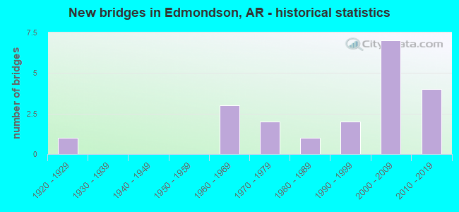
- New bridges - historical statistics
- 11920-1929
- 31960-1969
- 21970-1979
- 11980-1989
- 21990-1999
- 72000-2009
- 42010-2019


- Bridge Condition - Deck
- 15.0%Very good
- 60.0%Good
- 25.0%Satisfactory

- Bridge Condition - Superstructure
- 5.0%Excellent
- 35.0%Very good
- 35.0%Good
- 20.0%Satisfactory
- 5.0%Fair

- Bridge Condition - Substructure
- 20.0%Very good
- 50.0%Good
- 20.0%Satisfactory
- 10.0%Fair

- Bridge Condition - Channel
- 11.1%Excellent
- 33.3%Very good
- 5.6%Good
- 33.3%Satisfactory
- 16.7%Fair
Find on map >> Show street view
Structure Number: 1164, Location: 3.58 Miles East Jct Sh 79 (Lat: 35.147739, Lng: -90.337311), Route carried "on" structure: US 70, Year Built: 1929, Status: Open, Structure Length: 1.89m (6.20ft), Average Daily Traffic: 3,903 (year 2018), Truck Traffic: 1%, Average Future Daily Traffic: 1,730 (year 2028), Design Load: H 15, Features Intersected: Drainage Ditch
Minimum Vertical Clearance: 30+ m (98+ ft), Kilometerpoint: 5.761, Lanes on structure: 2, Owner: State Highway Agency, Approaching Roadway Width: 8.5m (27.9ft), Material/Design: Concrete, Design/Construction: Tee Beam, Number Of Spans In Main Unit: 1, Number Of Approach Spans: 2, Length of Maximum Span: 9.1m (29.9ft), Curb-To-Curb Width: 8.2m (26.9ft), Out-to-Out Width: 9.1m (29.9ft)
Condition: Deck: Satisfactory, Superstructure: Satisfactory, Substructure: Satisfactory, Channel: Satisfactory, Operating Rating: 30.8 metric tons, Method Used To Determine Operating Rating: Load Factor (LF), Inventory Rating: 18.1 metric tons, Method Used To Determine Inventory Rating: Load Factor (LF), Structural Evaluation: Somewhat better than minimum adequacy, Deck Geometry: High priority of corrective action, Waterway Adequacy: Equal to present desirable criteria, Approach Roadway Alignment: Equal to present desirable criteria, Length Of Structure Improvement: 2.65m (8.69ft), Designated Inspection Frequency: Every 24 months, Critical Feature Inspection Frequency: Every 24 months, Inspection Date: Febuary 2022, Roadway Improvement Cost: $125,000, Total Project Cost: $303,000, Deck Structure Type: Concrete Cast-file-Place, Wearing Surface/Protective System: Wearing Surface: Bituminous
Find on map >> Show street view
Structure Number: 4444, Location: 3.59 Miles West Of Sh 147 (Lat: 35.089758, Lng: -90.356847), Route carried "on" structure: County highway 18, Year Built: 1983, Status: Open, Structure Length: 2.83m (9.28ft), Average Daily Traffic: 122 (year 2018), Truck Traffic: 1%, Average Future Daily Traffic: 272 (year 2007), Design Load: H 15, Features Intersected: Ditch Number 18, Facility Carried by Structure: ProctorRd/B/L-3.64
Minimum Vertical Clearance: 30+ m (98+ ft), Kilometerpoint: 5.858, Lanes on structure: 2, Owner: County Highway Agency, Approaching Roadway Width: 6.0m (19.7ft), Material/Design: Concrete, Design/Construction: Channel Beam, Number Of Spans In Main Unit: 3, Length of Maximum Span: 9.4m (30.8ft), Curb-To-Curb Width: 8.5m (27.9ft), Out-to-Out Width: 9.3m (30.5ft)
Condition: Deck: Good, Superstructure: Good, Substructure: Fair, Channel: Fair, Operating Rating: 54.4 metric tons, Method Used To Determine Operating Rating: Load Factor (LF), Inventory Rating: 32.7 metric tons, Method Used To Determine Inventory Rating: Load Factor (LF), Structural Evaluation: Somewhat better than minimum adequacy, Deck Geometry: Equal to present minimum criteria, Waterway Adequacy: Equal to present desirable criteria, Approach Roadway Alignment: Equal to present desirable criteria, Designated Inspection Frequency: Every 24 months, Critical Feature Inspection Frequency: Every 24 months, Inspection Date: March 2021, Deck Structure Type: Concrete Precast Panels, Wearing Surface/Protective System: Wearing Surface: Monolithic Concrete
Find on map >> Show street view
Structure Number: 5134, Location: 2.4 Miles South Jct Us 70 (Lat: 35.110461, Lng: -90.293350), Route carried "on" structure: State highway 147, Year Built: 1969, Status: Open, Structure Length: 2.56m (8.40ft), Average Daily Traffic: 2,785 (year 2018), Truck Traffic: 1%, Average Future Daily Traffic: 3,461 (year 2028), Design Load: HS 20, Features Intersected: Ditch Number 49
Minimum Vertical Clearance: 30+ m (98+ ft), Kilometerpoint: 20.616, Lanes on structure: 2, Base Highway Network: Yes, Owner: State Highway Agency, Approaching Roadway Width: 13.4m (44.0ft), Skew: 1 degrees, Material/Design: Concrete, Design/Construction: Slab, Number Of Spans In Main Unit: 3, Length of Maximum Span: 8.5m (27.9ft), Curb or Sidewalk Widths: Left: 0.1m (0.3ft), Right: 0.1m (0.3ft), Curb-To-Curb Width: 13.1m (43.0ft), Out-to-Out Width: 14.1m (46.3ft)
Condition: Deck: Satisfactory, Superstructure: Satisfactory, Substructure: Good, Channel: Fair, Operating Rating: 54.4 metric tons, Method Used To Determine Operating Rating: Load Factor (LF), Inventory Rating: 32.7 metric tons, Method Used To Determine Inventory Rating: Load Factor (LF), Structural Evaluation: Equal to present minimum criteria, Deck Geometry: Equal to present minimum criteria, Waterway Adequacy: Better than present minimum criteria, Approach Roadway Alignment: Equal to present minimum criteria, Designated Inspection Frequency: Every 24 months, Critical Feature Inspection Frequency: Every 24 months, Inspection Date: January 2022, Deck Structure Type: Concrete Cast-file-Place, Wearing Surface/Protective System: Wearing Surface: Bituminous
Find on map >> Show street view
Structure Number: 5135, Location: 1.6 Miles South Jct Us 70 (Lat: 35.125531, Lng: -90.293119), Route carried "on" structure: State highway 147, Year Built: 1969, Status: Open, Structure Length: 2.29m (7.51ft), Average Daily Traffic: 3,100 (year 2018), Truck Traffic: 1%, Average Future Daily Traffic: 4,079 (year 2028), Design Load: HS 20, Features Intersected: Ditch Number 50
Minimum Vertical Clearance: 30+ m (98+ ft), Kilometerpoint: 22.289, Lanes on structure: 2, Base Highway Network: Yes, Owner: State Highway Agency, Approaching Roadway Width: 14.6m (47.9ft), Material/Design: Concrete, Design/Construction: Slab, Number Of Spans In Main Unit: 3, Length of Maximum Span: 7.6m (24.9ft), Curb or Sidewalk Widths: Left: 0.1m (0.3ft), Right: 0.1m (0.3ft), Curb-To-Curb Width: 13.2m (43.3ft), Out-to-Out Width: 14.1m (46.3ft)
Condition: Deck: Satisfactory, Superstructure: Satisfactory, Substructure: Very good, Channel: Fair, Operating Rating: 54.4 metric tons, Method Used To Determine Operating Rating: Load Factor (LF), Inventory Rating: 32.7 metric tons, Method Used To Determine Inventory Rating: Load Factor (LF), Structural Evaluation: Equal to present minimum criteria, Deck Geometry: Equal to present minimum criteria, Waterway Adequacy: Equal to present desirable criteria, Approach Roadway Alignment: Equal to present desirable criteria, Designated Inspection Frequency: Every 24 months, Critical Feature Inspection Frequency: Every 24 months, Inspection Date: January 2022, Deck Structure Type: Concrete Cast-file-Place, Wearing Surface/Protective System: Wearing Surface: Bituminous
Find on map >> Show street view
Structure Number: 5748, Location: 5.1 South Of Jct Us 70 (Lat: 35.073039, Lng: -90.293950), Route carried "on" structure: State highway 147, Year Built: 1979, Status: Open, Structure Length: 2.74m (8.99ft), Average Daily Traffic: 2,397 (year 2018), Truck Traffic: 1%, Average Future Daily Traffic: 2,966 (year 2028), Design Load: HS 20, Features Intersected: Ten Mile Bayou
Minimum Vertical Clearance: 30+ m (98+ ft), Kilometerpoint: 16.464, Lanes on structure: 2, Base Highway Network: Yes, Owner: State Highway Agency, Approaching Roadway Width: 12.2m (40.0ft), Material/Design: Concrete, Design/Construction: Slab, Number Of Spans In Main Unit: 3, Length of Maximum Span: 9.1m (29.9ft), Curb-To-Curb Width: 12.2m (40.0ft), Out-to-Out Width: 13.3m (43.6ft)
Condition: Deck: Good, Superstructure: Good, Substructure: Good, Channel: Good, Operating Rating: 54.4 metric tons, Method Used To Determine Operating Rating: Load Factor (LF), Inventory Rating: 32.7 metric tons, Method Used To Determine Inventory Rating: Load Factor (LF), Structural Evaluation: Better than present minimum criteria, Deck Geometry: Equal to present minimum criteria, Waterway Adequacy: Equal to present desirable criteria, Approach Roadway Alignment: Equal to present desirable criteria, Designated Inspection Frequency: Every 24 months, Critical Feature Inspection Frequency: Every 24 months, Inspection Date: January 2022, Deck Structure Type: Concrete Cast-file-Place, Wearing Surface/Protective System: Wearing Surface: Bituminous
Find on map >> Show street view
Structure Number: 6562, Location: 2.39 Miles Sw Of Sh 147 (Lat: 35.099097, Lng: -90.311308), Route carried "on" structure: State highway 131, Year Built: 1994, Status: Open, Structure Length: 3.20m (10.50ft), Average Daily Traffic: 170 (year 2019), Truck Traffic: 8%, Average Future Daily Traffic: 309 (year 2028), Design Load: HS 20, Features Intersected: 10 Mi Bayou Cutoff Ditch
Minimum Vertical Clearance: 30+ m (98+ ft), Kilometerpoint: 1.078, Lanes on structure: 2, Owner: State Highway Agency, Approaching Roadway Width: 8.2m (26.9ft), Material/Design: Concrete, Design/Construction: Slab, Number Of Spans In Main Unit: 3, Length of Maximum Span: 10.7m (35.1ft), Curb-To-Curb Width: 8.5m (27.9ft), Out-to-Out Width: 9.4m (30.8ft)
Condition: Deck: Good, Superstructure: Good, Substructure: Very good, Channel: Very good, Operating Rating: 54.4 metric tons, Method Used To Determine Operating Rating: Load Factor (LF), Inventory Rating: 32.7 metric tons, Method Used To Determine Inventory Rating: Load Factor (LF), Structural Evaluation: Better than present minimum criteria, Deck Geometry: Equal to present minimum criteria, Waterway Adequacy: Equal to present desirable criteria, Approach Roadway Alignment: Equal to present desirable criteria, Designated Inspection Frequency: Every 24 months, Critical Feature Inspection Frequency: Every 24 months, Inspection Date: November 2020, Deck Structure Type: Concrete Cast-file-Place, Wearing Surface/Protective System: Wearing Surface: Bituminous, Deck Protection: Epoxy Coated Reinforcing
Find on map >> Show street view
Structure Number: 7173, Location: 11.96 Miles Ne Jct Sh 131 (Lat: 35.096372, Lng: -90.293572), Route carried "on" structure: State highway 147, Year Built: 2011, Status: Open, Structure Length: 4.85m (15.91ft), Average Daily Traffic: 2,785 (year 2018), Truck Traffic: 5%, Average Future Daily Traffic: 3,300 (year 2030), Design Load: HL 93, Features Intersected: 10 Mile Bayou Cutoff Dit
Minimum Vertical Clearance: 30+ m (98+ ft), Kilometerpoint: 19.055, Lanes on structure: 2, Owner: State Highway Agency, Approaching Roadway Width: 12.2m (40.0ft), Material/Design: Steel continuous, Design/Construction: Stringer/Multi-beam, Number Of Spans In Main Unit: 3, Length of Maximum Span: 16.3m (53.5ft), Curb-To-Curb Width: 12.2m (40.0ft), Out-to-Out Width: 13.2m (43.3ft)
Condition: Deck: Good, Superstructure: Very good, Substructure: Very good, Channel: Excellent, Operating Rating: 37.2 metric tons, Method Used To Determine Operating Rating: Load Factor (LF), Inventory Rating: 21.8 metric tons, Method Used To Determine Inventory Rating: Load Factor (LF), Structural Evaluation: Somewhat better than minimum adequacy, Deck Geometry: Equal to present minimum criteria, Waterway Adequacy: Equal to present desirable criteria, Approach Roadway Alignment: Superior to present desirable criteria, Designated Inspection Frequency: Every 24 months, Critical Feature Inspection Frequency: Every 24 months, Inspection Date: June 2021, Deck Structure Type: Concrete Cast-file-Place, Wearing Surface/Protective System: Wearing Surface: Monolithic Concrete, Deck Protection: Epoxy Coated Reinforcing
Find on map >> Show street view
Structure Number: 7181, Location: 1.11 Mi Sw Of Jct Sh 147 (Lat: 35.118144, Lng: -90.310828), Route carried "on" structure: State highway 131, Year Built: 2012, Status: Open, Structure Length: 7.57m (24.84ft), Average Daily Traffic: 320 (year 2018), Truck Traffic: 3%, Average Future Daily Traffic: 420 (year 2031), Design Load: HL 93, Features Intersected: Fifteen Mile Bayou
Minimum Vertical Clearance: 30+ m (98+ ft), Kilometerpoint: 3.203, Lanes on structure: 2, Owner: State Highway Agency, Approaching Roadway Width: 8.5m (27.9ft), Skew: 3 degrees, Material/Design: Steel continuous, Design/Construction: Stringer/Multi-beam, Number Of Spans In Main Unit: 6, Length of Maximum Span: 13.4m (44.0ft), Curb-To-Curb Width: 8.5m (27.9ft), Out-to-Out Width: 9.5m (31.2ft)
Condition: Deck: Very good, Superstructure: Excellent, Substructure: Good, Channel: Very good, Operating Rating: 54.4 metric tons, Method Used To Determine Operating Rating: Load and Resistance Factor (LRFR), Inventory Rating: 32.7 metric tons, Method Used To Determine Inventory Rating: Load and Resistance Factor (LRFR), Structural Evaluation: Better than present minimum criteria, Deck Geometry: Equal to present minimum criteria, Waterway Adequacy: Superior to present desirable criteria, Approach Roadway Alignment: Equal to present minimum criteria, Designated Inspection Frequency: Every 24 months, Critical Feature Inspection Frequency: Every 24 months, Inspection Date: July 2020, Deck Structure Type: Concrete Cast-file-Place, Wearing Surface/Protective System: Wearing Surface: Monolithic Concrete, Deck Protection: Epoxy Coated Reinforcing
Find on map >> Show street view
Structure Number: 7182, Location: 0.09 Mi West Of Jct Sh147 (Lat: 35.118375, Lng: -90.295289), Route carried "on" structure: State highway 131, Year Built: 2011, Status: Open, Structure Length: 4.79m (15.72ft), Average Daily Traffic: 320 (year 2018), Truck Traffic: 3%, Average Future Daily Traffic: 500 (year 2030), Design Load: HL 93, Features Intersected: 15 Mile Bayou
Minimum Vertical Clearance: 30+ m (98+ ft), Kilometerpoint: 4.667, Lanes on structure: 2, Owner: State Highway Agency, Approaching Roadway Width: 9.8m (32.2ft), Skew: 1 degrees, Material/Design: Steel continuous, Design/Construction: Stringer/Multi-beam, Number Of Spans In Main Unit: 5, Length of Maximum Span: 10.4m (34.1ft), Curb-To-Curb Width: 8.5m (27.9ft), Out-to-Out Width: 9.5m (31.2ft)
Condition: Deck: Good, Superstructure: Very good, Substructure: Very good, Channel: Excellent, Operating Rating: 54.4 metric tons, Method Used To Determine Operating Rating: Load Factor (LF), Inventory Rating: 32.7 metric tons, Method Used To Determine Inventory Rating: Load Factor (LF), Structural Evaluation: Equal to present desirable criteria, Deck Geometry: Equal to present minimum criteria, Waterway Adequacy: Equal to present desirable criteria, Approach Roadway Alignment: Better than present minimum criteria, Designated Inspection Frequency: Every 24 months, Critical Feature Inspection Frequency: Every 24 months, Inspection Date: June 2021, Deck Structure Type: Concrete Cast-file-Place, Wearing Surface/Protective System: Wearing Surface: Monolithic Concrete, Deck Protection: Epoxy Coated Reinforcing
Find on map >> Show street view
Structure Number: 7183, Location: 1.25 Mi South Jct Us 70 (Lat: 35.129050, Lng: -90.293053), Route carried "on" structure: State highway 147, Year Built: 2012, Status: Open, Structure Length: 6.83m (22.41ft), Average Daily Traffic: 3,100 (year 2018), Truck Traffic: 5%, Average Future Daily Traffic: 4,200 (year 2030), Design Load: HL 93, Features Intersected: Fifteen Mile Bayou
Minimum Vertical Clearance: 30+ m (98+ ft), Kilometerpoint: 22.676, Lanes on structure: 2, Owner: State Highway Agency, Approaching Roadway Width: 12.2m (40.0ft), Skew: 4 degrees, Material/Design: Steel, Design/Construction: Stringer/Multi-beam, Number Of Spans In Main Unit: 5, Length of Maximum Span: 16.2m (53.1ft), Curb-To-Curb Width: 12.2m (40.0ft), Out-to-Out Width: 13.2m (43.3ft)
Condition: Deck: Good, Superstructure: Very good, Substructure: Good, Channel: Very good, Operating Rating: 54.4 metric tons, Method Used To Determine Operating Rating: Load Factor (LF), Inventory Rating: 32.7 metric tons, Method Used To Determine Inventory Rating: Load Factor (LF), Structural Evaluation: Better than present minimum criteria, Deck Geometry: Equal to present minimum criteria, Waterway Adequacy: Superior to present desirable criteria, Approach Roadway Alignment: Superior to present desirable criteria, Designated Inspection Frequency: Every 24 months, Critical Feature Inspection Frequency: Every 24 months, Inspection Date: July 2020, Deck Structure Type: Concrete Cast-file-Place, Wearing Surface/Protective System: Wearing Surface: Monolithic Concrete, Deck Protection: Epoxy Coated Reinforcing
Find on map >> Show street view
Structure Number: 21772, Location: 2.64 Mi West of Hwy 313 (Lat: 35.118775, Lng: -90.355500), Route carried "on" structure: County highway 14, Year Built: 1996, Status: Posted for load, Structure Length: 1.63m (5.35ft), Average Daily Traffic: 195 (year 2018), Truck Traffic: 1%, Average Future Daily Traffic: 205 (year 2007), Features Intersected: Ditch, Facility Carried by Structure: Mudline/Z-B/L-2.64
Minimum Vertical Clearance: 30+ m (98+ ft), Kilometerpoint: 4.249, Lanes on structure: 2, Owner: County Highway Agency, Approaching Roadway Width: 5.5m (18.0ft), Material/Design: Steel, Design/Construction: Orthotropic, Number Of Spans In Main Unit: 1, Length of Maximum Span: 14.4m (47.2ft), Curb-To-Curb Width: 6.0m (19.7ft), Out-to-Out Width: 6.0m (19.7ft)
Condition: Deck: Satisfactory, Superstructure: Satisfactory, Substructure: Fair, Channel: Satisfactory, Operating Rating: 14.5 metric tons, Method Used To Determine Operating Rating: Load Factor (LF), Inventory Rating: 8.2 metric tons, Method Used To Determine Inventory Rating: Load Factor (LF), Structural Evaluation: High priority of corrective action, Deck Geometry: High priority of corrective action, Waterway Adequacy: Equal to present desirable criteria, Approach Roadway Alignment: Equal to present desirable criteria, Bridge Posting: Required (Relationship of Operating Rating to Maximum Legal Load: > 39.9% below), Designated Inspection Frequency: Every 24 months, Critical Feature Inspection Frequency: Every 24 months, Inspection Date: July 2021, Critical Feature Inspection Date: July 2021, Deck Structure Type: Wood or Timber, Wearing Surface/Protective System: Wearing Surface: Wood or Timber
Find on map >> Show street view
Structure Number: 2276, Location: 3.16 Mi S Of Us 70 & Cr13 (Lat: 35.096919, Lng: -90.364647), Route carried "on" structure: County highway 13, Year Built: 2005, Status: Posted for load, Structure Length: 2.71m (8.89ft), Average Daily Traffic: 73 (year 2018), Truck Traffic: 1%, Average Future Daily Traffic: 305 (year 2007), Features Intersected: Ten Mile Bayou Cutoff, Facility Carried by Structure: Proctor Junction/B
Minimum Vertical Clearance: 30+ m (98+ ft), Kilometerpoint: 7.355, Lanes on structure: 1, Owner: County Highway Agency, Approaching Roadway Width: 5.8m (19.0ft), Material/Design: Steel, Design/Construction: Orthotropic, Number Of Spans In Main Unit: 1, Length of Maximum Span: 25.4m (83.3ft), Curb-To-Curb Width: 6.4m (21.0ft), Out-to-Out Width: 6.6m (21.7ft)
Condition: Deck: Good, Superstructure: Fair, Substructure: Good, Channel: Very good, Operating Rating: 12.7 metric tons, Method Used To Determine Operating Rating: Allowable Stress (AS), Inventory Rating: 7.3 metric tons, Method Used To Determine Inventory Rating: Allowable Stress (AS), Structural Evaluation: High priority of corrective action, Deck Geometry: Somewhat better than minimum adequacy, Waterway Adequacy: Equal to present desirable criteria, Approach Roadway Alignment: Equal to present minimum criteria, Bridge Posting: Required (Relationship of Operating Rating to Maximum Legal Load: > 39.9% below), Designated Inspection Frequency: Every 24 months, Critical Feature Inspection Frequency: Every 24 months, Inspection Date: July 2021, Critical Feature Inspection Date: July 2021, Deck Structure Type: Steel plate, Wearing Surface/Protective System: Wearing Surface: Other
Find on map >> Show street view
Structure Number: 22882, Location: 3.10 Mi West Int Sh 147 (Lat: 35.089969, Lng: -90.348289), Route carried "on" structure: County highway 18, Year Built: 2007, Status: Open, Structure Length: 6.67m (21.88ft), Average Daily Traffic: 61 (year 2018), Truck Traffic: 1%, Average Future Daily Traffic: 277 (year 2007), Design Load: HS 20, Features Intersected: Fifteen Mile Bayou, Facility Carried by Structure: Proctor/Z-B/L-3.13
Minimum Vertical Clearance: 30+ m (98+ ft), Kilometerpoint: 5.037, Lanes on structure: 2, Owner: County Highway Agency, Approaching Roadway Width: 6.7m (22.0ft), Skew: 2 degrees, Material/Design: Concrete, Design/Construction: Slab, Number Of Spans In Main Unit: 5, Length of Maximum Span: 13.2m (43.3ft), Curb or Sidewalk Widths: Left: 0.5m (1.6ft), Right: 0.5m (1.6ft), Curb-To-Curb Width: 7.6m (24.9ft), Out-to-Out Width: 8.2m (26.9ft)
Condition: Deck: Very good, Superstructure: Very good, Substructure: Good, Channel: Satisfactory, Operating Rating: 54.4 metric tons, Method Used To Determine Operating Rating: Load Factor (LF), Inventory Rating: 32.7 metric tons, Method Used To Determine Inventory Rating: Load Factor (LF), Structural Evaluation: Better than present minimum criteria, Deck Geometry: Equal to present minimum criteria, Waterway Adequacy: Equal to present desirable criteria, Approach Roadway Alignment: Equal to present desirable criteria, Designated Inspection Frequency: Every 24 months, Critical Feature Inspection Frequency: Every 24 months, Inspection Date: March 2021, Deck Structure Type: Concrete Precast Panels, Wearing Surface/Protective System: Wearing Surface: Monolithic Concrete
Find on map >> Show street view
Structure Number: 23115, Location: 1.56 Mi West Sh 131 Int (Lat: 35.118744, Lng: -90.337608), Route carried "on" structure: County highway 14, Year Built: 2007, Status: Open, Structure Length: 1.84m (6.04ft), Average Daily Traffic: 195 (year 2018), Truck Traffic: 1%, Average Future Daily Traffic: 286 (year 2007), Features Intersected: Ditch, Facility Carried by Structure: Mudline/Z-B/L-1.56
Minimum Vertical Clearance: 30+ m (98+ ft), Kilometerpoint: 2.511, Lanes on structure: 1, Owner: County Highway Agency, Approaching Roadway Width: 5.5m (18.0ft), Material/Design: Steel, Design/Construction: Orthotropic, Number Of Spans In Main Unit: 1, Length of Maximum Span: 16.2m (53.1ft), Curb-To-Curb Width: 5.2m (17.1ft), Out-to-Out Width: 5.2m (17.1ft)
Condition: Deck: Good, Superstructure: Good, Substructure: Satisfactory, Channel: Satisfactory, Operating Rating: 43.5 metric tons, Method Used To Determine Operating Rating: Load Factor (LF), Inventory Rating: 26.3 metric tons, Method Used To Determine Inventory Rating: Load Factor (LF), Structural Evaluation: Equal to present minimum criteria, Deck Geometry: High priority of replacement, Waterway Adequacy: Equal to present desirable criteria, Approach Roadway Alignment: Somewhat better than minimum adequacy, Designated Inspection Frequency: Every 24 months, Critical Feature Inspection Frequency: Every 24 months, Inspection Date: July 2021, Critical Feature Inspection Date: July 2021, Deck Structure Type: Steel plate, Wearing Surface/Protective System: Wearing Surface: Other
Find on map >> Show street view
Structure Number: A6825, Location: Jct Sh 50 & I-40 (Lat: 35.148300, Lng: -90.328506), Route carried "on" structure: Interstate 40, Year Built: 2002, Status: Open, Structure Length: 3.66m (12.01ft), Average Daily Traffic: 19,500 (year 2018), Truck Traffic: 5%, Average Future Daily Traffic: 25,337 (year 2028), Design Load: HS 20, Features Intersected: Sh-50/Sec-3/L-0.04
Minimum Vertical Clearance: 30+ m (98+ ft), Kilometerpoint: 433.187, Lanes on structure: 2, Lanes under structure: 2, Base Highway Network: Yes, Owner: State Highway Agency, Approaching Roadway Width: 12.2m (40.0ft), Material/Design: Steel continuous, Design/Construction: Stringer/Multi-beam, Number Of Spans In Main Unit: 3, Length of Maximum Span: 15.8m (51.8ft), Curb-To-Curb Width: 12.2m (40.0ft), Out-to-Out Width: 13.1m (43.0ft)
Condition: Deck: Good, Superstructure: Very good, Substructure: Good, Operating Rating: 54.4 metric tons, Method Used To Determine Operating Rating: Load Factor (LF), Inventory Rating: 32.7 metric tons, Method Used To Determine Inventory Rating: Load Factor (LF), Structural Evaluation: Better than present minimum criteria, Deck Geometry: Better than present minimum criteria, Underclear: Somewhat better than minimum adequacy, Approach Roadway Alignment: Equal to present desirable criteria, Designated Inspection Frequency: Every 24 months, Critical Feature Inspection Frequency: Every 24 months, Inspection Date: March 2020, Deck Structure Type: Concrete Cast-file-Place, Wearing Surface/Protective System: Wearing Surface: Monolithic Concrete, Deck Protection: Epoxy Coated Reinforcing
Find on map >> Show street view
Structure Number: A6843, Location: 2.5 Mi W Jct Sh 147 &I-40 (Lat: 35.148731, Lng: -90.337311), Route carried "on" structure: Interstate 40, Year Built: 2002, Status: Open, Structure Length: 2.50m (8.20ft), Average Daily Traffic: 19,500 (year 2018), Truck Traffic: 44%, Average Future Daily Traffic: 25,337 (year 2028), Design Load: HS 20, Features Intersected: Drainage Ditch Number 16
Minimum Vertical Clearance: 30+ m (98+ ft), Kilometerpoint: 432.206, Lanes on structure: 2, Base Highway Network: Yes, Owner: State Highway Agency, Approaching Roadway Width: 12.2m (40.0ft), Material/Design: Steel, Design/Construction: Stringer/Multi-beam, Number Of Spans In Main Unit: 1, Length of Maximum Span: 24.4m (80.1ft), Curb-To-Curb Width: 12.2m (40.0ft), Out-to-Out Width: 13.1m (43.0ft)
Condition: Deck: Good, Superstructure: Very good, Substructure: Good, Channel: Very good, Operating Rating: 54.4 metric tons, Method Used To Determine Operating Rating: Load Factor (LF), Inventory Rating: 32.7 metric tons, Method Used To Determine Inventory Rating: Load Factor (LF), Structural Evaluation: Better than present minimum criteria, Deck Geometry: Better than present minimum criteria, Waterway Adequacy: Equal to present desirable criteria, Approach Roadway Alignment: Equal to present desirable criteria, Designated Inspection Frequency: Every 24 months, Critical Feature Inspection Frequency: Every 24 months, Inspection Date: Febuary 2022, Deck Structure Type: Concrete Cast-file-Place, Wearing Surface/Protective System: Wearing Surface: Monolithic Concrete, Deck Protection: Epoxy Coated Reinforcing
Find on map >> Show street view
Structure Number: B6825, Location: Jct I-40 & Sh 50 (Lat: 35.148072, Lng: -90.328528), Route carried "on" structure: Interstate 40, Year Built: 2002, Status: Open, Structure Length: 3.66m (12.01ft), Average Daily Traffic: 19,500 (year 2018), Truck Traffic: 44%, Average Future Daily Traffic: 25,337 (year 2028), Design Load: HS 20+Mod, Features Intersected: Sh-50/Sec-3/L-0.02
Minimum Vertical Clearance: 30+ m (98+ ft), Kilometerpoint: 433.187, Lanes on structure: 2, Lanes under structure: 2, Base Highway Network: Yes, Owner: State Highway Agency, Approaching Roadway Width: 12.2m (40.0ft), Material/Design: Steel continuous, Design/Construction: Stringer/Multi-beam, Number Of Spans In Main Unit: 3, Length of Maximum Span: 15.8m (51.8ft), Curb-To-Curb Width: 12.2m (40.0ft), Out-to-Out Width: 13.1m (43.0ft)
Condition: Deck: Good, Superstructure: Very good, Substructure: Good, Operating Rating: 54.4 metric tons, Method Used To Determine Operating Rating: Load Factor (LF), Inventory Rating: 32.7 metric tons, Method Used To Determine Inventory Rating: Load Factor (LF), Structural Evaluation: Better than present minimum criteria, Deck Geometry: Better than present minimum criteria, Underclear: Somewhat better than minimum adequacy, Approach Roadway Alignment: Equal to present desirable criteria, Designated Inspection Frequency: Every 24 months, Critical Feature Inspection Frequency: Every 24 months, Inspection Date: March 2020, Deck Structure Type: Concrete Cast-file-Place, Wearing Surface/Protective System: Wearing Surface: Monolithic Concrete, Deck Protection: Epoxy Coated Reinforcing
Find on map >> Show street view
Structure Number: B6843, Location: 3.59 Miles East Of Sh 218 (Lat: 35.148492, Lng: -90.337350), Route carried "on" structure: Interstate 40, Year Built: 2002, Status: Open, Structure Length: 2.50m (8.20ft), Average Daily Traffic: 19,500 (year 2018), Truck Traffic: 44%, Average Future Daily Traffic: 25,337 (year 2028), Design Load: HS 20+Mod, Features Intersected: Ditch Number 16
Minimum Vertical Clearance: 30+ m (98+ ft), Kilometerpoint: 432.206, Lanes on structure: 2, Base Highway Network: Yes, Owner: State Highway Agency, Approaching Roadway Width: 12.2m (40.0ft), Material/Design: Steel, Design/Construction: Stringer/Multi-beam, Number Of Spans In Main Unit: 1, Length of Maximum Span: 24.4m (80.1ft), Curb-To-Curb Width: 12.2m (40.0ft), Out-to-Out Width: 13.1m (43.0ft)
Condition: Deck: Satisfactory, Superstructure: Good, Substructure: Good, Channel: Very good, Operating Rating: 54.4 metric tons, Method Used To Determine Operating Rating: Load Factor (LF), Inventory Rating: 32.7 metric tons, Method Used To Determine Inventory Rating: Load Factor (LF), Structural Evaluation: Better than present minimum criteria, Deck Geometry: Better than present minimum criteria, Waterway Adequacy: Equal to present desirable criteria, Approach Roadway Alignment: Equal to present desirable criteria, Designated Inspection Frequency: Every 24 months, Critical Feature Inspection Frequency: Every 24 months, Inspection Date: Febuary 2022, Deck Structure Type: Concrete Cast-file-Place, Wearing Surface/Protective System: Wearing Surface: Monolithic Concrete, Deck Protection: Epoxy Coated Reinforcing
Find on map >> Show street view
Structure Number: C3849, Location: 3.59 Mi E Of Jct Sh 218 (Lat: 35.148939, Lng: -90.337311), Route carried "on" structure: ServiceInterstate 40, Year Built: 1967, Status: Open, Structure Length: 2.29m (7.51ft), Average Daily Traffic: 44 (year 2014), Truck Traffic: 1%, Average Future Daily Traffic: 110 (year 2034), Design Load: H 15, Features Intersected: Ditch Number 16
Minimum Vertical Clearance: 30+ m (98+ ft), Kilometerpoint: 432.206, Lanes on structure: 2, Owner: State Highway Agency, Approaching Roadway Width: 6.2m (20.3ft), Material/Design: Concrete, Design/Construction: Slab, Number Of Spans In Main Unit: 3, Length of Maximum Span: 7.6m (24.9ft), Curb or Sidewalk Widths: Left: 0.2m (0.7ft), Right: 0.2m (0.7ft), Curb-To-Curb Width: 7.3m (24.0ft), Out-to-Out Width: 7.9m (25.9ft)
Condition: Deck: Good, Superstructure: Good, Substructure: Satisfactory, Channel: Satisfactory, Operating Rating: 39.9 metric tons, Method Used To Determine Operating Rating: Load Factor (LF), Inventory Rating: 23.6 metric tons, Method Used To Determine Inventory Rating: Load Factor (LF), Structural Evaluation: Equal to present minimum criteria, Deck Geometry: Equal to present minimum criteria, Waterway Adequacy: Equal to present desirable criteria, Approach Roadway Alignment: Equal to present desirable criteria, Length Of Structure Improvement: 3.08m (10.10ft), Designated Inspection Frequency: Every 24 months, Critical Feature Inspection Frequency: Every 24 months, Inspection Date: Febuary 2022, Roadway Improvement Cost: $533,000, Total Project Cost: $1,239,000, Deck Structure Type: Concrete Cast-file-Place, Wearing Surface/Protective System: Wearing Surface: Bituminous
Find on map >> Show street view
Structure Number: M3956, Location: 0.51 Mi W Of Jct Sh 147 (Lat: 35.118342, Lng: -90.302292), Route carried "on" structure: State highway 131, Year Built: 1975, Status: Open, Structure Length: 1.74m (5.71ft), Average Daily Traffic: 320 (year 2018), Truck Traffic: 1%, Average Future Daily Traffic: 433 (year 2028), Design Load: H 15, Features Intersected: Ditch Number 14
Minimum Vertical Clearance: 30+ m (98+ ft), Kilometerpoint: 4.023, Lanes on structure: 2, Owner: State Highway Agency, Approaching Roadway Width: 7.5m (24.6ft), Material/Design: Concrete, Design/Construction: Channel Beam, Number Of Spans In Main Unit: 3, Length of Maximum Span: 5.8m (19.0ft), Curb or Sidewalk Widths: Left: 0.2m (0.7ft), Right: 0.2m (0.7ft), Curb-To-Curb Width: 8.0m (26.2ft), Out-to-Out Width: 8.6m (28.2ft)
Condition: Deck: Very good, Superstructure: Good, Substructure: Satisfactory, Channel: Satisfactory, Operating Rating: 38.1 metric tons, Method Used To Determine Operating Rating: Load Factor (LF), Inventory Rating: 22.7 metric tons, Method Used To Determine Inventory Rating: Load Factor (LF), Structural Evaluation: Equal to present minimum criteria, Deck Geometry: Somewhat better than minimum adequacy, Waterway Adequacy: Equal to present desirable criteria, Approach Roadway Alignment: Equal to present desirable criteria, Designated Inspection Frequency: Every 24 months, Critical Feature Inspection Frequency: Every 24 months, Inspection Date: May 2020, Deck Structure Type: Concrete Precast Panels, Wearing Surface/Protective System: Wearing Surface: Monolithic Concrete
Find on map >> Show street view
Structure Number: A6825, Location: Jct Sh 50 & I-40 (Lat: 35.148300, Lng: -90.328506), Route carried "under" structure: State highway 50, Structure Length: 0. m, Average Daily Traffic: 280 (year 2014), Truck Traffic: 1%, Features Intersected: SH 50 SEC 3, Facility Carried by Structure: I-40WB/Se52/269.17
Minimum Vertical Clearance: 4.80m (15.75ft), Kilometerpoint: 0.064, Length of Maximum Span: 0.0m
Find on map >> Show street view
Structure Number: B6825, Location: Jct I-40 & Sh 50 (Lat: 35.148072, Lng: -90.328528), Route carried "under" structure: State highway 50, Structure Length: 0. m, Average Daily Traffic: 280 (year 2014), Truck Traffic: 1%, Features Intersected: SH 50, Facility Carried by Structure: I-40EB/Se52/269.17
Minimum Vertical Clearance: 4.77m (15.65ft), Kilometerpoint: 0.032, Length of Maximum Span: 0.0m