Bridge Statistics for Edwardsville, Kansas (KS)
Condition, Traffic, Stress, Structural Evaluation, Project Costs
- National Bridge Inventory (NBI) Statistics
- 28Number of bridges
- 784ft / 239mTotal length
- $170,000Total costs
- 564,012Total average daily traffic
- 46,415Total average daily truck traffic
- National Bridge Inventory (NBI) Registered Bridges for Edwardsville
- No street view available for this location
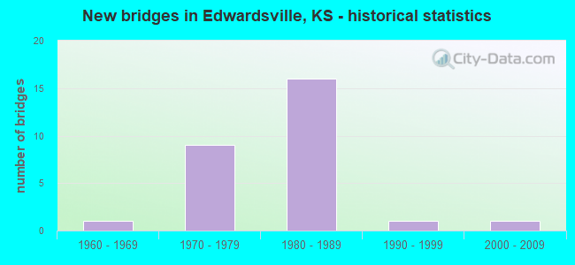
- New bridges - historical statistics
- 11960-1969
- 91970-1979
- 161980-1989
- 11990-1999
- 12000-2009
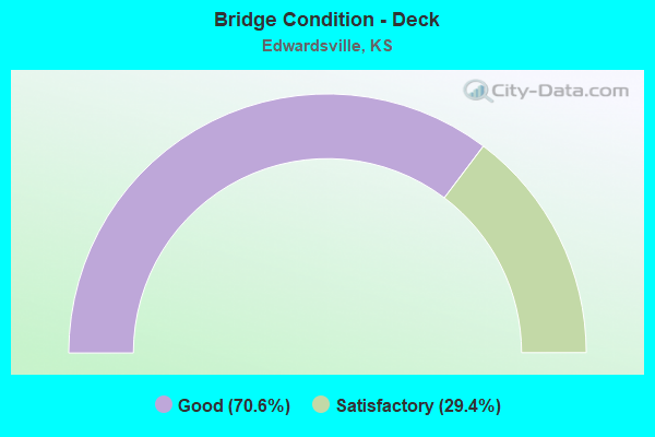
- Bridge Condition - Deck
- 70.6%Good
- 29.4%Satisfactory
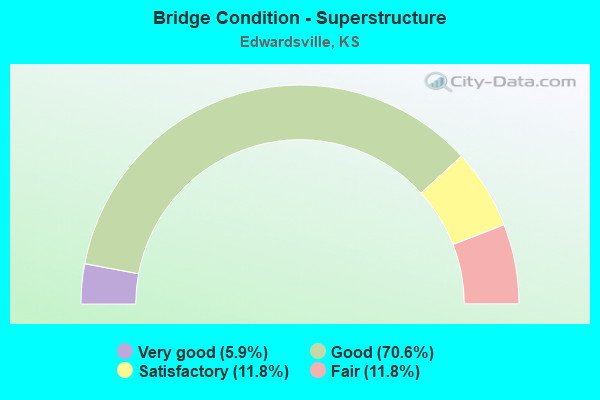
- Bridge Condition - Superstructure
- 5.9%Very good
- 70.6%Good
- 11.8%Satisfactory
- 11.8%Fair
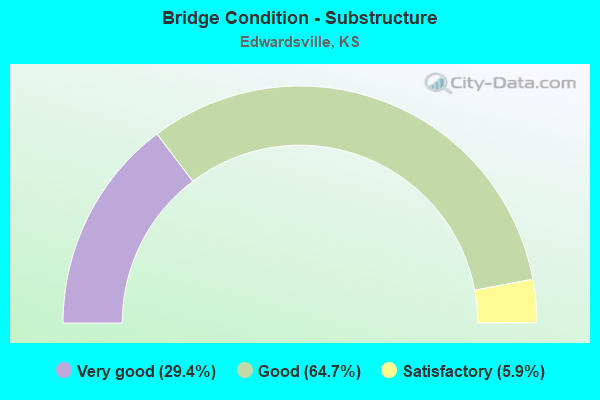
- Bridge Condition - Substructure
- 29.4%Very good
- 64.7%Good
- 5.9%Satisfactory

- Bridge Condition - Channel
- 70.0%Good
- 30.0%Satisfactory
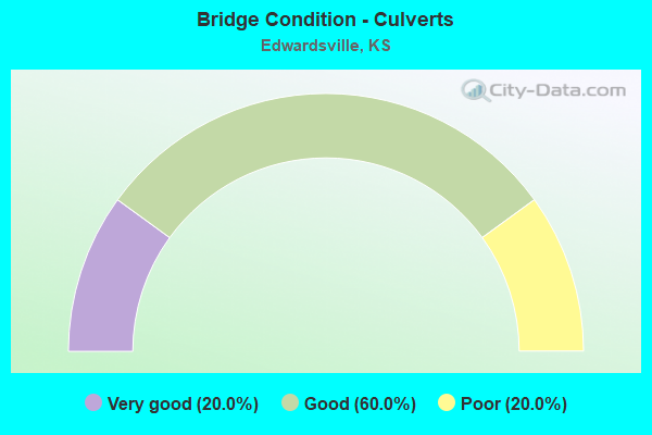
- Bridge Condition - Culverts
- 20.0%Very good
- 60.0%Good
- 20.0%Poor
Find on map >> Show street view
Structure Number: 407651052515003, Location: 1.63 MILES W of I-435 (Lat: 39.062861, Lng: -94.821681), Route carried "on" structure: City street 2515, Year Built: 1998, Status: Open, Structure Length: 0.69m (2.26ft), Average Daily Traffic: 2,400 (year 2014), Truck Traffic: 10%, Average Future Daily Traffic: 3,000 (year 2041), Design Load: HS 20, Features Intersected: BETTS CREEK DRAINAGE, Facility Carried by Structure: N 4th STREET
Minimum Vertical Clearance: 5.85m (19.19ft), Kilometerpoint: 0.000, Lanes on structure: 3, Owner: City or Municipal Highway Agency, Approaching Roadway Width: 7.3m (24.0ft), Material/Design: Concrete, Design/Construction: Culvert, Number Of Spans In Main Unit: 2, Length of Maximum Span: 3.4m (11.2ft)
Condition: Channel: Good, Culverts: Very good, Operating Rating: 71.0 metric tons, Method Used To Determine Operating Rating: Load Factor (LF), Inventory Rating: 42.5 metric tons, Method Used To Determine Inventory Rating: Load Factor (LF), Structural Evaluation: Equal to present desirable criteria, Waterway Adequacy: Better than present minimum criteria, Approach Roadway Alignment: Equal to present desirable criteria, Designated Inspection Frequency: Every 24 months, Inspection Date: Febuary 2021
Find on map >> Show street view
Structure Number: 507651050000001, Location: 1100'E OF 102ND. ST. (Lat: 39.080000, Lng: -94.811667), Route carried "on" structure: City street , Year Built: 2006, Status: Open, Structure Length: 2.98m (9.78ft), Average Daily Traffic: 350 (year 2007), Truck Traffic: 15%, Average Future Daily Traffic: 610 (year 2041), Design Load: HS 20, Features Intersected: BETTS CREEK, Facility Carried by Structure: SWARTZ ROAD
Minimum Vertical Clearance: 5.48m (17.98ft), Kilometerpoint: 0.000, Lanes on structure: 2, Owner: City or Municipal Highway Agency, Approaching Roadway Width: 5.4m (17.7ft), Skew: 2 degrees, Material/Design: Concrete continuous, Design/Construction: Slab, Number Of Spans In Main Unit: 3, Length of Maximum Span: 11.6m (38.1ft), Curb-To-Curb Width: 8.6m (28.2ft), Out-to-Out Width: 9.2m (30.2ft)
Condition: Deck: Good, Superstructure: Good, Substructure: Very good, Channel: Good, Operating Rating: 62.1 metric tons, Method Used To Determine Operating Rating: Load Factor (LF), Inventory Rating: 37.1 metric tons, Method Used To Determine Inventory Rating: Load Factor (LF), Structural Evaluation: Better than present minimum criteria, Deck Geometry: Equal to present minimum criteria, Waterway Adequacy: Equal to present minimum criteria, Approach Roadway Alignment: Equal to present desirable criteria, Designated Inspection Frequency: Every 24 months, Inspection Date: Febuary 2021, Deck Structure Type: Concrete Cast-file-Place
Find on map >> Show street view
Structure Number: 507651050000002, Location: 1250'W OF 98TH. ST. (Lat: 39.050908, Lng: -94.811111), Route carried "on" structure: City street , Year Built: 1984, Status: Open, Structure Length: 1.54m (5.05ft), Average Daily Traffic: 700 (year 2007), Truck Traffic: 10%, Average Future Daily Traffic: 1,225 (year 2041), Design Load: HS 20, Features Intersected: BETTS CREEK, Facility Carried by Structure: WOODEND ROAD
Minimum Vertical Clearance: 30.47m (99.97ft), Kilometerpoint: 0.000, Lanes on structure: 2, Owner: City or Municipal Highway Agency, Approaching Roadway Width: 7.3m (24.0ft), Material/Design: Concrete, Design/Construction: Culvert, Number Of Spans In Main Unit: 4, Length of Maximum Span: 3.7m (12.1ft), Curb or Sidewalk Widths: Left: 2.4m (7.9ft), Right: 0.0m
Condition: Channel: Satisfactory, Culverts: Good, Operating Rating: 54.4 metric tons, Method Used To Determine Operating Rating: Field evaluation and documented engineering judgment, Inventory Rating: 32.7 metric tons, Method Used To Determine Inventory Rating: Field evaluation and documented engineering judgment, Structural Evaluation: Better than present minimum criteria, Waterway Adequacy: Equal to present desirable criteria, Approach Roadway Alignment: Equal to present desirable criteria, Length Of Structure Improvement: 1.62m (5.31ft), Designated Inspection Frequency: Every 24 months, Inspection Date: Febuary 2021, Bridge Improvement Cost: $100,000, Roadway Improvement Cost: $20,000, Total Project Cost: $170,000
Find on map >> Show street view
Structure Number: 999903201050841, Location: 2.31 MI E K7 (Lat: 39.063611, Lng: -94.832778), Route carried "on" structure: State highway 32, Year Built: 1971, Status: Open, Structure Length: 4.05m (13.29ft), Average Daily Traffic: 7,425 (year 2020), Truck Traffic: 8%, Average Future Daily Traffic: 8,204 (year 2041), Design Load: HS 20, Features Intersected: MISSION CREEK
Minimum Vertical Clearance: 30.47m (99.97ft), Kilometerpoint: 6.989, Lanes on structure: 2, Base Highway Network: Yes, Owner: State Highway Agency, Approaching Roadway Width: 12.2m (40.0ft), Skew: 3 degrees, Material/Design: Concrete continuous, Design/Construction: Slab, Number Of Spans In Main Unit: 3, Length of Maximum Span: 15.8m (51.8ft), Curb-To-Curb Width: 12.2m (40.0ft), Out-to-Out Width: 12.8m (42.0ft)
Condition: Deck: Satisfactory, Superstructure: Good, Substructure: Very good, Channel: Good, Operating Rating: 59.9 metric tons, Method Used To Determine Operating Rating: Load Factor (LF), Inventory Rating: 36.3 metric tons, Method Used To Determine Inventory Rating: Load Factor (LF), Structural Evaluation: Better than present minimum criteria, Deck Geometry: Better than present minimum criteria, Waterway Adequacy: Equal to present minimum criteria, Approach Roadway Alignment: Equal to present desirable criteria, Length Of Structure Improvement: 13.27m (43.54ft), Designated Inspection Frequency: Every 24 months, Inspection Date: June 2021, Deck Structure Type: Concrete Cast-file-Place, Wearing Surface/Protective System: Wearing Surface: Low Slump Concrete
Find on map >> Show street view
Structure Number: 999903201050851, Location: 2.32 MI E K7 (Lat: 39.063333, Lng: -94.832778), Route carried "on" structure: State highway 32, Year Built: 1971, Status: Open, Structure Length: 4.05m (13.29ft), Average Daily Traffic: 7,425 (year 2020), Truck Traffic: 8%, Average Future Daily Traffic: 8,204 (year 2041), Design Load: HS 20, Features Intersected: MISSION CREEK
Minimum Vertical Clearance: 30.47m (99.97ft), Kilometerpoint: 6.993, Lanes on structure: 2, Base Highway Network: Yes, Owner: State Highway Agency, Approaching Roadway Width: 12.2m (40.0ft), Skew: 3 degrees, Material/Design: Concrete continuous, Design/Construction: Slab, Number Of Spans In Main Unit: 3, Length of Maximum Span: 15.8m (51.8ft), Curb-To-Curb Width: 12.2m (40.0ft), Out-to-Out Width: 12.8m (42.0ft)
Condition: Deck: Satisfactory, Superstructure: Good, Substructure: Very good, Channel: Good, Operating Rating: 59.9 metric tons, Method Used To Determine Operating Rating: Load Factor (LF), Inventory Rating: 36.3 metric tons, Method Used To Determine Inventory Rating: Load Factor (LF), Structural Evaluation: Better than present minimum criteria, Deck Geometry: Better than present minimum criteria, Waterway Adequacy: Equal to present desirable criteria, Approach Roadway Alignment: Equal to present desirable criteria, Length Of Structure Improvement: 13.27m (43.54ft), Designated Inspection Frequency: Every 24 months, Inspection Date: June 2021, Deck Structure Type: Concrete Cast-file-Place, Wearing Surface/Protective System: Wearing Surface: Low Slump Concrete
Find on map >> Show street view
Structure Number: 999903201050861, Location: 1.63 MILES W I-435 (Lat: 39.062222, Lng: -94.821389), Route carried "on" structure: State highway 32, Year Built: 1971, Status: Open, Structure Length: 1.11m (3.64ft), Average Daily Traffic: 7,425 (year 2020), Truck Traffic: 8%, Average Future Daily Traffic: 8,204 (year 2041), Design Load: H 20, Features Intersected: BETTS CREEK DRAINAGE
Minimum Vertical Clearance: 30.47m (99.97ft), Kilometerpoint: 7.998, Lanes on structure: 4, Base Highway Network: Yes, Owner: State Highway Agency, Approaching Roadway Width: 19.8m (65.0ft), Skew: 3 degrees, Material/Design: Concrete, Design/Construction: Culvert, Number Of Spans In Main Unit: 2, Length of Maximum Span: 4.3m (14.1ft), Curb-To-Curb Width: 19.8m (65.0ft), Out-to-Out Width: 41.9m (137.5ft)
Condition: Channel: Good, Culverts: Poor, Operating Rating: 41.7 metric tons, Method Used To Determine Operating Rating: Load Factor (LF), Inventory Rating: 25.4 metric tons, Method Used To Determine Inventory Rating: Load Factor (LF), Structural Evaluation: Meets minimum limits, Deck Geometry: Better than present minimum criteria, Waterway Adequacy: Better than present minimum criteria, Approach Roadway Alignment: Equal to present desirable criteria, Length Of Structure Improvement: 3.63m (11.91ft), Designated Inspection Frequency: Every 12 months, Inspection Date: June 2021, Deck Structure Type: Concrete Cast-file-Place, Wearing Surface/Protective System: Wearing Surface: Bituminous
Find on map >> Show street view
Structure Number: 999903201050871, Location: 0.83 MILES W I-435 (Lat: 39.060833, Lng: -94.807778), Route carried "on" structure: State highway 32, Year Built: 1968, Status: Open, Structure Length: 1.33m (4.36ft), Average Daily Traffic: 7,425 (year 2020), Truck Traffic: 8%, Average Future Daily Traffic: 8,204 (year 2041), Design Load: H 20, Features Intersected: BETTS CREEK
Minimum Vertical Clearance: 30.47m (99.97ft), Kilometerpoint: 9.164, Lanes on structure: 5, Base Highway Network: Yes, Owner: State Highway Agency, Approaching Roadway Width: 19.5m (64.0ft), Material/Design: Concrete, Design/Construction: Culvert, Number Of Spans In Main Unit: 3, Length of Maximum Span: 4.3m (14.1ft), Curb-To-Curb Width: 19.5m (64.0ft), Out-to-Out Width: 29.7m (97.4ft)
Condition: Channel: Satisfactory, Culverts: Good, Operating Rating: 53.4 metric tons, Method Used To Determine Operating Rating: Load Factor (LF), Inventory Rating: 32.0 metric tons, Method Used To Determine Inventory Rating: Load Factor (LF), Structural Evaluation: Better than present minimum criteria, Deck Geometry: Meets minimum limits, Waterway Adequacy: Equal to present minimum criteria, Approach Roadway Alignment: Equal to present desirable criteria, Length Of Structure Improvement: 4.35m (14.27ft), Designated Inspection Frequency: Every 24 months, Inspection Date: June 2021, Deck Structure Type: Concrete Cast-file-Place, Wearing Surface/Protective System: Wearing Surface: Bituminous
Find on map >> Show street view
Structure Number: 999903201051711, Location: 1.18 MI W I435 SD RD RT (Lat: 39.061111, Lng: -94.816111), Route carried "on" structure: ServiceCity street 385, Year Built: 1975, Status: Open, Structure Length: 0.88m (2.89ft), Average Daily Traffic: 528 (year 2020), Truck Traffic: 1%, Average Future Daily Traffic: 8,121 (year 2041), Design Load: H 20, Features Intersected: BETTS CREEK DRAINAGE, Facility Carried by Structure: 9TH T0 RT
Minimum Vertical Clearance: 30.47m (99.97ft), Kilometerpoint: 0.027, Lanes on structure: 2, Owner: State Highway Agency, Approaching Roadway Width: 13.4m (44.0ft), Material/Design: Concrete, Design/Construction: Culvert, Number Of Spans In Main Unit: 2, Length of Maximum Span: 4.3m (14.1ft), Curb-To-Curb Width: 13.4m (44.0ft), Out-to-Out Width: 26.2m (86.0ft)
Condition: Channel: Satisfactory, Culverts: Good, Operating Rating: 42.6 metric tons, Method Used To Determine Operating Rating: Load Factor (LF), Inventory Rating: 25.4 metric tons, Method Used To Determine Inventory Rating: Load Factor (LF), Structural Evaluation: Equal to present minimum criteria, Deck Geometry: Superior to present desirable criteria, Waterway Adequacy: Better than present minimum criteria, Approach Roadway Alignment: Somewhat better than minimum adequacy, Length Of Structure Improvement: 2.89m (9.48ft), Designated Inspection Frequency: Every 24 months, Inspection Date: June 2021, Deck Structure Type: Concrete Cast-file-Place, Wearing Surface/Protective System: Wearing Surface: Monolithic Concrete
Find on map >> Show street view
Structure Number: 999943501051941, Location: KANSAS RIVER-I435 (Lat: 39.045556, Lng: -94.789444), Route carried "on" structure: Interstate 435, Year Built: 1981, Status: Open, Structure Length: 59.53m (195.31ft), Average Daily Traffic: 33,386 (year 2020), Truck Traffic: 9%, Average Future Daily Traffic: 60,299 (year 2041), Design Load: HS 20+Mod, Features Intersected: KS RIV- RR-HOLLIDAY DR
Minimum Vertical Clearance: 30.47m (99.97ft), Kilometerpoint: 0.328, Lanes on structure: 3, Lanes under structure: 4, Base Highway Network: Yes, Owner: State Highway Agency, Approaching Roadway Width: 17.1m (56.1ft), Skew: 1 degrees, Material/Design: Steel continuous, Design/Construction: Stringer/Multi-beam, Number Of Spans In Main Unit: 11, Length of Maximum Span: 73.2m (240.2ft), Curb-To-Curb Width: 17.1m (56.1ft), Out-to-Out Width: 17.6m (57.7ft)
Condition: Deck: Satisfactory, Superstructure: Satisfactory, Substructure: Satisfactory, Channel: Good, Operating Rating: 79.8 metric tons, Method Used To Determine Operating Rating: Load Factor (LF), Inventory Rating: 48.1 metric tons, Method Used To Determine Inventory Rating: Load Factor (LF), Structural Evaluation: Equal to present minimum criteria, Deck Geometry: Equal to present minimum criteria, Underclear: Superior to present desirable criteria, Waterway Adequacy: Better than present minimum criteria, Approach Roadway Alignment: Equal to present desirable criteria, Length Of Structure Improvement: 195.30m (640.75ft), Designated Inspection Frequency: Every 12 months, Underwater Inspection Frequency: Every 60 months, Other Special Inspection Frequency: Every 24 months, Inspection Date: November 2021, Underwater Inspection Date: September 2020, Other Special Inspection Date: November 2021, Deck Structure Type: Concrete Cast-file-Place, Wearing Surface/Protective System: Wearing Surface: Low Slump Concrete
Find on map >> Show street view
Structure Number: 999943501051951, Location: KANSAS RIVER-I435 (Lat: 39.045556, Lng: -94.789167), Route carried "on" structure: Interstate 435, Year Built: 1981, Status: Open, Structure Length: 59.53m (195.31ft), Average Daily Traffic: 33,386 (year 2020), Truck Traffic: 9%, Average Future Daily Traffic: 60,299 (year 2041), Design Load: HS 20+Mod, Features Intersected: KS R; RR; HOLLIDAY DR
Minimum Vertical Clearance: 30.47m (99.97ft), Kilometerpoint: 0.328, Lanes on structure: 3, Lanes under structure: 4, Base Highway Network: Yes, Owner: State Highway Agency, Approaching Roadway Width: 17.1m (56.1ft), Skew: 1 degrees, Material/Design: Steel continuous, Design/Construction: Stringer/Multi-beam, Number Of Spans In Main Unit: 11, Length of Maximum Span: 73.2m (240.2ft), Curb-To-Curb Width: 17.1m (56.1ft), Out-to-Out Width: 17.6m (57.7ft)
Condition: Deck: Good, Superstructure: Fair, Substructure: Good, Channel: Good, Operating Rating: 78.0 metric tons, Method Used To Determine Operating Rating: Load Factor (LF), Inventory Rating: 47.2 metric tons, Method Used To Determine Inventory Rating: Load Factor (LF), Structural Evaluation: Somewhat better than minimum adequacy, Deck Geometry: Equal to present minimum criteria, Underclear: Superior to present desirable criteria, Waterway Adequacy: Better than present minimum criteria, Approach Roadway Alignment: Equal to present desirable criteria, Length Of Structure Improvement: 195.29m (640.72ft), Designated Inspection Frequency: Every 12 months, Underwater Inspection Frequency: Every 60 months, Other Special Inspection Frequency: Every 24 months, Inspection Date: November 2021, Underwater Inspection Date: September 2020, Other Special Inspection Date: November 2021, Deck Structure Type: Concrete Cast-file-Place, Wearing Surface/Protective System: Wearing Surface: Epoxy Overlay
Find on map >> Show street view
Structure Number: 999943501051961, Location: 0.51 MILES N JOHNSON C/L (Lat: 39.050833, Lng: -94.790278), Route carried "on" structure: Interstate 435, Year Built: 1980, Status: Open, Structure Length: 4.69m (15.39ft), Average Daily Traffic: 33,386 (year 2020), Truck Traffic: 9%, Average Future Daily Traffic: 60,299 (year 2041), Design Load: HS 20+Mod, Features Intersected: WOODEND ROAD
Minimum Vertical Clearance: 30.47m (99.97ft), Kilometerpoint: 0.837, Lanes on structure: 3, Lanes under structure: 3, Base Highway Network: Yes, Owner: State Highway Agency, Approaching Roadway Width: 17.1m (56.1ft), Material/Design: Steel continuous, Design/Construction: Stringer/Multi-beam, Number Of Spans In Main Unit: 3, Length of Maximum Span: 24.2m (79.4ft), Curb-To-Curb Width: 19.5m (64.0ft), Out-to-Out Width: 20.3m (66.6ft)
Condition: Deck: Good, Superstructure: Satisfactory, Substructure: Good, Operating Rating: 56.2 metric tons, Method Used To Determine Operating Rating: Load Factor (LF), Inventory Rating: 33.6 metric tons, Method Used To Determine Inventory Rating: Load Factor (LF), Structural Evaluation: Equal to present minimum criteria, Deck Geometry: Superior to present desirable criteria, Underclear: Superior to present desirable criteria, Approach Roadway Alignment: Equal to present desirable criteria, Length Of Structure Improvement: 15.40m (50.52ft), Designated Inspection Frequency: Every 24 months, Inspection Date: June 2021, Deck Structure Type: Concrete Cast-file-Place, Wearing Surface/Protective System: Wearing Surface: Low Slump Concrete
Find on map >> Show street view
Structure Number: 999943501051971, Location: 0.52 MILES N JOHNSON C/L (Lat: 39.050833, Lng: -94.789722), Route carried "on" structure: Interstate 435, Year Built: 1980, Status: Open, Structure Length: 4.69m (15.39ft), Average Daily Traffic: 33,386 (year 2020), Truck Traffic: 9%, Average Future Daily Traffic: 60,299 (year 2041), Design Load: HS 20+Mod, Features Intersected: WOODEND ROAD
Minimum Vertical Clearance: 30.47m (99.97ft), Kilometerpoint: 0.824, Lanes on structure: 4, Lanes under structure: 3, Base Highway Network: Yes, Owner: State Highway Agency, Approaching Roadway Width: 19.5m (64.0ft), Material/Design: Steel continuous, Design/Construction: Stringer/Multi-beam, Number Of Spans In Main Unit: 3, Length of Maximum Span: 24.2m (79.4ft), Curb-To-Curb Width: 19.5m (64.0ft), Out-to-Out Width: 20.1m (65.9ft)
Condition: Deck: Good, Superstructure: Fair, Substructure: Good, Operating Rating: 56.2 metric tons, Method Used To Determine Operating Rating: Load Factor (LF), Inventory Rating: 33.6 metric tons, Method Used To Determine Inventory Rating: Load Factor (LF), Structural Evaluation: Somewhat better than minimum adequacy, Deck Geometry: Somewhat better than minimum adequacy, Underclear: Superior to present desirable criteria, Approach Roadway Alignment: Equal to present desirable criteria, Length Of Structure Improvement: 15.40m (50.52ft), Designated Inspection Frequency: Every 24 months, Inspection Date: June 2021, Deck Structure Type: Concrete Cast-file-Place, Wearing Surface/Protective System: Wearing Surface: Low Slump Concrete
Find on map >> Show street view
Structure Number: 999943501051981, Location: I-435 / K-32 JCT (Lat: 39.061944, Lng: -94.791944), Route carried "on" structure: Interstate 435, Year Built: 1979, Status: Open, Structure Length: 11.56m (37.93ft), Average Daily Traffic: 32,311 (year 2020), Truck Traffic: 9%, Average Future Daily Traffic: 58,357 (year 2041), Design Load: HS 20+Mod, Features Intersected: K-32 & UP RAILROAD
Minimum Vertical Clearance: 30.47m (99.97ft), Kilometerpoint: 2.047, Lanes on structure: 3, Lanes under structure: 4, Base Highway Network: Yes, Owner: State Highway Agency, Approaching Roadway Width: 17.1m (56.1ft), Material/Design: Steel continuous, Design/Construction: Stringer/Multi-beam, Number Of Spans In Main Unit: 6, Length of Maximum Span: 21.9m (71.9ft), Curb-To-Curb Width: 17.1m (56.1ft), Out-to-Out Width: 17.6m (57.7ft)
Condition: Deck: Good, Superstructure: Good, Substructure: Very good, Operating Rating: 56.1 metric tons, Method Used To Determine Operating Rating: Load Factor (LF), Inventory Rating: 33.6 metric tons, Method Used To Determine Inventory Rating: Load Factor (LF), Structural Evaluation: Better than present minimum criteria, Deck Geometry: Equal to present minimum criteria, Underclear: Equal to present desirable criteria, Approach Roadway Alignment: Equal to present desirable criteria, Length Of Structure Improvement: 37.93m (124.44ft), Designated Inspection Frequency: Every 24 months, Inspection Date: June 2021, Deck Structure Type: Concrete Cast-file-Place, Wearing Surface/Protective System: Wearing Surface: Low Slump Concrete
Find on map >> Show street view
Structure Number: 999943501051991, Location: I-435 / K-32 JCT (Lat: 39.061944, Lng: -94.791389), Route carried "on" structure: Interstate 435, Year Built: 1979, Status: Open, Structure Length: 11.58m (37.99ft), Average Daily Traffic: 32,311 (year 2020), Truck Traffic: 9%, Average Future Daily Traffic: 58,357 (year 2041), Design Load: HS 20+Mod, Features Intersected: K-32 & UP RAILROAD
Minimum Vertical Clearance: 30.47m (99.97ft), Kilometerpoint: 2.042, Lanes on structure: 3, Lanes under structure: 4, Base Highway Network: Yes, Owner: State Highway Agency, Approaching Roadway Width: 17.1m (56.1ft), Material/Design: Steel continuous, Design/Construction: Stringer/Multi-beam, Number Of Spans In Main Unit: 6, Length of Maximum Span: 21.9m (71.9ft), Curb-To-Curb Width: 17.1m (56.1ft), Out-to-Out Width: 17.6m (57.7ft)
Condition: Deck: Good, Superstructure: Good, Substructure: Good, Operating Rating: 89.8 metric tons, Method Used To Determine Operating Rating: Load Factor (LF), Inventory Rating: 60.6 metric tons, Method Used To Determine Inventory Rating: Load Factor (LF), Structural Evaluation: Better than present minimum criteria, Deck Geometry: Equal to present minimum criteria, Underclear: Better than present minimum criteria, Approach Roadway Alignment: Equal to present desirable criteria, Length Of Structure Improvement: 37.98m (124.61ft), Designated Inspection Frequency: Every 24 months, Inspection Date: June 2021, Deck Structure Type: Concrete Cast-file-Place, Wearing Surface/Protective System: Wearing Surface: Low Slump Concrete
Find on map >> Show street view
Structure Number: 999943501052021, Location: 1.28 MILES N K-32 (Lat: 39.080000, Lng: -94.798056), Route carried "on" structure: Interstate 435, Year Built: 1979, Status: Open, Structure Length: 4.73m (15.52ft), Average Daily Traffic: 30,440 (year 2020), Truck Traffic: 10%, Average Future Daily Traffic: 54,978 (year 2041), Design Load: HS 20+Mod, Features Intersected: SWARTZ ROAD
Minimum Vertical Clearance: 30.47m (99.97ft), Kilometerpoint: 4.131, Lanes on structure: 3, Lanes under structure: 2, Base Highway Network: Yes, Owner: State Highway Agency, Approaching Roadway Width: 17.1m (56.1ft), Skew: 1 degrees, Material/Design: Steel continuous, Design/Construction: Stringer/Multi-beam, Number Of Spans In Main Unit: 3, Length of Maximum Span: 25.0m (82.0ft), Curb-To-Curb Width: 17.1m (56.1ft), Out-to-Out Width: 17.9m (58.7ft)
Condition: Deck: Good, Superstructure: Good, Substructure: Good, Operating Rating: 65.3 metric tons, Method Used To Determine Operating Rating: Load Factor (LF), Inventory Rating: 39.0 metric tons, Method Used To Determine Inventory Rating: Load Factor (LF), Structural Evaluation: Better than present minimum criteria, Deck Geometry: Equal to present minimum criteria, Underclear: Equal to present minimum criteria, Approach Roadway Alignment: Equal to present desirable criteria, Length Of Structure Improvement: 15.51m (50.89ft), Designated Inspection Frequency: Every 24 months, Inspection Date: June 2021, Deck Structure Type: Concrete Cast-file-Place, Wearing Surface/Protective System: Wearing Surface: Low Slump Concrete
Find on map >> Show street view
Structure Number: 999943501052031, Location: 1.29 MILES N K-32 (Lat: 39.080000, Lng: -94.798333), Route carried "on" structure: Interstate 435, Year Built: 1981, Status: Open, Structure Length: 4.73m (15.52ft), Average Daily Traffic: 30,440 (year 2020), Truck Traffic: 10%, Average Future Daily Traffic: 54,978 (year 2041), Design Load: HS 20+Mod, Features Intersected: SWARTZ ROAD
Minimum Vertical Clearance: 30.47m (99.97ft), Kilometerpoint: 4.142, Lanes on structure: 3, Lanes under structure: 2, Base Highway Network: Yes, Owner: State Highway Agency, Approaching Roadway Width: 17.1m (56.1ft), Skew: 1 degrees, Material/Design: Steel continuous, Design/Construction: Stringer/Multi-beam, Number Of Spans In Main Unit: 3, Length of Maximum Span: 25.0m (82.0ft), Curb-To-Curb Width: 17.1m (56.1ft), Out-to-Out Width: 17.9m (58.7ft)
Condition: Deck: Satisfactory, Superstructure: Good, Substructure: Good, Operating Rating: 66.2 metric tons, Method Used To Determine Operating Rating: Load Factor (LF), Inventory Rating: 39.6 metric tons, Method Used To Determine Inventory Rating: Load Factor (LF), Structural Evaluation: Better than present minimum criteria, Deck Geometry: Equal to present minimum criteria, Underclear: Better than present minimum criteria, Approach Roadway Alignment: Equal to present desirable criteria, Length Of Structure Improvement: 15.51m (50.89ft), Designated Inspection Frequency: Every 24 months, Inspection Date: June 2021, Deck Structure Type: Concrete Cast-file-Place, Wearing Surface/Protective System: Wearing Surface: Low Slump Concrete
Find on map >> Show street view
Structure Number: 999943501052041, Location: 1.82 MILES N K-32 (Lat: 39.087222, Lng: -94.801389), Route carried "on" structure: City street 2644, Year Built: 1981, Status: Open, Structure Length: 11.66m (38.25ft), Average Daily Traffic: 741 (year 2020), Truck Traffic: 7%, Average Future Daily Traffic: 1,101 (year 2041), Design Load: HS 20, Features Intersected: I-435 HIGHWAY, Facility Carried by Structure: KANSAS AVE
Minimum Vertical Clearance: 30.47m (99.97ft), Kilometerpoint: 1.252, Lanes on structure: 4, Lanes under structure: 6, Owner: State Highway Agency, Approaching Roadway Width: 20.0m (65.6ft), Skew: 22 degrees, Material/Design: Steel continuous, Design/Construction: Stringer/Multi-beam, Number Of Spans In Main Unit: 4, Length of Maximum Span: 38.1m (125.0ft), Curb-To-Curb Width: 20.0m (65.6ft), Out-to-Out Width: 22.7m (74.5ft)
Condition: Deck: Good, Superstructure: Very good, Substructure: Good, Operating Rating: 57.8 metric tons, Method Used To Determine Operating Rating: Load Factor (LF), Inventory Rating: 34.6 metric tons, Method Used To Determine Inventory Rating: Load Factor (LF), Structural Evaluation: Better than present minimum criteria, Deck Geometry: Better than present minimum criteria, Underclear: Somewhat better than minimum adequacy, Approach Roadway Alignment: Somewhat better than minimum adequacy, Length Of Structure Improvement: 38.25m (125.49ft), Designated Inspection Frequency: Every 24 months, Inspection Date: June 2021, Deck Structure Type: Concrete Cast-file-Place, Wearing Surface/Protective System: Wearing Surface: Low Slump Concrete
Find on map >> Show street view
Structure Number: 999943501052051, Location: 3.07 MI N JOHNSON COLN (Lat: 39.101667, Lng: -94.810833), Route carried "on" structure: City street 2520, Year Built: 1981, Status: Open, Structure Length: 20.97m (68.80ft), Average Daily Traffic: 512 (year 2020), Truck Traffic: 5%, Average Future Daily Traffic: 625 (year 2041), Design Load: HS 20, Features Intersected: I-435 HWY AND RAMPS, Facility Carried by Structure: RIVERVIEW ST
Minimum Vertical Clearance: 30.47m (99.97ft), Kilometerpoint: 2.084, Lanes on structure: 2, Lanes under structure: 8, Owner: State Highway Agency, Approaching Roadway Width: 8.5m (27.9ft), Material/Design: Steel continuous, Design/Construction: Stringer/Multi-beam, Number Of Spans In Main Unit: 6, Length of Maximum Span: 40.5m (132.9ft), Curb-To-Curb Width: 8.5m (27.9ft), Out-to-Out Width: 9.1m (29.9ft)
Condition: Deck: Good, Superstructure: Good, Substructure: Very good, Operating Rating: 60.8 metric tons, Method Used To Determine Operating Rating: Load Factor (LF), Inventory Rating: 37.2 metric tons, Method Used To Determine Inventory Rating: Load Factor (LF), Structural Evaluation: Better than present minimum criteria, Deck Geometry: Somewhat better than minimum adequacy, Underclear: Equal to present desirable criteria, Approach Roadway Alignment: Somewhat better than minimum adequacy, Length Of Structure Improvement: 68.80m (225.72ft), Designated Inspection Frequency: Every 24 months, Inspection Date: June 2021, Deck Structure Type: Concrete Cast-file-Place, Wearing Surface/Protective System: Wearing Surface: Low Slump Concrete
Find on map >> Show street view
Structure Number: 999943501052061, Location: 4.38 MI N-JOHNSON CO LINE (Lat: 39.103889, Lng: -94.810833), Route carried "on" structure: Interstate 435, Year Built: 1981, Status: Open, Structure Length: 6.36m (20.87ft), Average Daily Traffic: 31,937 (year 2020), Truck Traffic: 5%, Average Future Daily Traffic: 57,682 (year 2041), Design Load: HS 20+Mod, Features Intersected: RAMP TO I-70 EASTBOUND
Minimum Vertical Clearance: 30.47m (99.97ft), Kilometerpoint: 7.078, Lanes on structure: 3, Lanes under structure: 2, Base Highway Network: Yes, Owner: State Highway Agency, Approaching Roadway Width: 17.1m (56.1ft), Material/Design: Steel continuous, Design/Construction: Stringer/Multi-beam, Number Of Spans In Main Unit: 3, Length of Maximum Span: 31.7m (104.0ft), Curb-To-Curb Width: 17.1m (56.1ft), Out-to-Out Width: 17.9m (58.7ft)
Condition: Deck: Good, Superstructure: Good, Substructure: Good, Operating Rating: 64.2 metric tons, Method Used To Determine Operating Rating: Load Factor (LF), Inventory Rating: 38.5 metric tons, Method Used To Determine Inventory Rating: Load Factor (LF), Structural Evaluation: Better than present minimum criteria, Deck Geometry: Equal to present minimum criteria, Underclear: Better than present minimum criteria, Approach Roadway Alignment: Equal to present desirable criteria, Length Of Structure Improvement: 20.86m (68.44ft), Designated Inspection Frequency: Every 24 months, Inspection Date: June 2021, Deck Structure Type: Concrete Cast-file-Place, Wearing Surface/Protective System: Wearing Surface: Low Slump Concrete
Find on map >> Show street view
Structure Number: 999943501052071, Location: 4.39 MI N-JOHNSON COLN SB (Lat: 39.103889, Lng: -94.811111), Route carried "on" structure: Interstate 435, Year Built: 1983, Status: Open, Structure Length: 6.36m (20.87ft), Average Daily Traffic: 31,937 (year 2020), Truck Traffic: 5%, Average Future Daily Traffic: 57,682 (year 2041), Design Load: HS 20+Mod, Features Intersected: RAMP TO I-70 EB
Minimum Vertical Clearance: 30.47m (99.97ft), Kilometerpoint: 7.086, Lanes on structure: 4, Lanes under structure: 3, Base Highway Network: Yes, Owner: State Highway Agency, Approaching Roadway Width: 17.1m (56.1ft), Material/Design: Steel continuous, Design/Construction: Stringer/Multi-beam, Number Of Spans In Main Unit: 3, Length of Maximum Span: 31.7m (104.0ft), Curb-To-Curb Width: 20.7m (67.9ft), Out-to-Out Width: 21.5m (70.5ft)
Condition: Deck: Good, Superstructure: Good, Substructure: Good, Operating Rating: 64.2 metric tons, Method Used To Determine Operating Rating: Load Factor (LF), Inventory Rating: 38.5 metric tons, Method Used To Determine Inventory Rating: Load Factor (LF), Structural Evaluation: Better than present minimum criteria, Deck Geometry: Equal to present minimum criteria, Underclear: Superior to present desirable criteria, Approach Roadway Alignment: Equal to present desirable criteria, Length Of Structure Improvement: 20.86m (68.44ft), Designated Inspection Frequency: Every 24 months, Inspection Date: June 2021, Deck Structure Type: Concrete Cast-file-Place, Wearing Surface/Protective System: Wearing Surface: Low Slump Concrete
Find on map >> Show street view
Structure Number: 999943501052361, Location: 2.28 MILES N K-32, SB- (Lat: 39.092222, Lng: -94.806944), Route carried "on" structure: Interstate 435, Year Built: 1984, Status: Open, Structure Length: 8.04m (26.38ft), Average Daily Traffic: 32,530 (year 2020), Truck Traffic: 10%, Average Future Daily Traffic: 58,753 (year 2041), Design Load: HS 20+Mod, Features Intersected: 98TH ST
Minimum Vertical Clearance: 30.47m (99.97ft), Kilometerpoint: 5.718, Lanes on structure: 3, Lanes under structure: 2, Base Highway Network: Yes, Owner: State Highway Agency, Approaching Roadway Width: 17.1m (56.1ft), Skew: 5 degrees, Material/Design: Steel continuous, Design/Construction: Stringer/Multi-beam, Number Of Spans In Main Unit: 3, Length of Maximum Span: 40.2m (131.9ft), Curb-To-Curb Width: 17.1m (56.1ft), Out-to-Out Width: 17.9m (58.7ft)
Condition: Deck: Satisfactory, Superstructure: Good, Substructure: Good, Operating Rating: 85.5 metric tons, Method Used To Determine Operating Rating: Load Factor (LF), Inventory Rating: 51.2 metric tons, Method Used To Determine Inventory Rating: Load Factor (LF), Structural Evaluation: Better than present minimum criteria, Deck Geometry: Equal to present minimum criteria, Underclear: Superior to present desirable criteria, Approach Roadway Alignment: Equal to present desirable criteria, Length Of Structure Improvement: 26.39m (86.58ft), Designated Inspection Frequency: Every 24 months, Inspection Date: June 2021, Deck Structure Type: Concrete Cast-file-Place, Wearing Surface/Protective System: Wearing Surface: Low Slump Concrete
Find on map >> Show street view
Structure Number: 999943501052371, Location: 2.30 MILES N K-32 (Lat: 39.092778, Lng: -94.806944), Route carried "on" structure: Interstate 435, Year Built: 1984, Status: Open, Structure Length: 8.27m (27.13ft), Average Daily Traffic: 32,530 (year 2020), Truck Traffic: 10%, Average Future Daily Traffic: 58,753 (year 2041), Design Load: HS 20+Mod, Features Intersected: 98TH STREET
Minimum Vertical Clearance: 30.47m (99.97ft), Kilometerpoint: 5.782, Lanes on structure: 3, Lanes under structure: 2, Base Highway Network: Yes, Owner: State Highway Agency, Approaching Roadway Width: 17.1m (56.1ft), Skew: 5 degrees, Material/Design: Steel continuous, Design/Construction: Stringer/Multi-beam, Number Of Spans In Main Unit: 3, Length of Maximum Span: 41.3m (135.5ft), Curb-To-Curb Width: 17.1m (56.1ft), Out-to-Out Width: 17.9m (58.7ft)
Condition: Deck: Good, Superstructure: Good, Substructure: Good, Operating Rating: 89.8 metric tons, Method Used To Determine Operating Rating: Load Factor (LF), Inventory Rating: 57.2 metric tons, Method Used To Determine Inventory Rating: Load Factor (LF), Structural Evaluation: Better than present minimum criteria, Deck Geometry: Equal to present minimum criteria, Underclear: Better than present minimum criteria, Approach Roadway Alignment: Equal to present desirable criteria, Length Of Structure Improvement: 27.13m (89.01ft), Designated Inspection Frequency: Every 24 months, Inspection Date: June 2021, Deck Structure Type: Concrete Cast-file-Place, Wearing Surface/Protective System: Wearing Surface: Low Slump Concrete
Find on map >> Show street view
Structure Number: 999943501051981, Location: I-435 / K-32 JCT (Lat: 39.061944, Lng: -94.791944), Route carried "under" structure: State highway 32, Year Built: 1979, Structure Length: 0. m, Average Daily Traffic: 7,425 (year 2020), Truck Traffic: 8%, Features Intersected: K-32 & UP RAILROAD, Facility Carried by Structure: I-435 SB HIGHWAY
Minimum Vertical Clearance: 7.62m (25.00ft), Kilometerpoint: 10.561, Lanes on structure: 3, Lanes under structure: 4, Material/Design: Steel continuous, Design/Construction: Stringer/Multi-beam, Length of Maximum Span: 21.9m (71.9ft)
Find on map >> Show street view
Structure Number: 999943501051991, Location: I-435 / K-32 JCT (Lat: 39.061944, Lng: -94.791389), Route carried "under" structure: State highway 32, Year Built: 1979, Structure Length: 0. m, Average Daily Traffic: 7,425 (year 2020), Truck Traffic: 8%, Features Intersected: K-32 & UP RAILROAD, Facility Carried by Structure: I-435 NB HIGHWAY
Minimum Vertical Clearance: 7.62m (25.00ft), Kilometerpoint: 10.598, Lanes on structure: 3, Lanes under structure: 4, Material/Design: Steel continuous, Design/Construction: Stringer/Multi-beam, Length of Maximum Span: 21.9m (71.9ft)
Find on map >> Show street view
Structure Number: 999943501052041, Location: 1.82 MILES N K-32 (Lat: 39.087222, Lng: -94.801389), Route carried "under" structure: Interstate 435, Year Built: 1981, Structure Length: 0. m, Average Daily Traffic: 30,440 (year 2020), Truck Traffic: 10%, Features Intersected: I-435 HIGHWAY, Facility Carried by Structure: KANSAS AVE
Minimum Vertical Clearance: 4.97m (16.31ft), Kilometerpoint: 4.991, Lanes on structure: 4, Lanes under structure: 6, Material/Design: Steel continuous, Design/Construction: Stringer/Multi-beam, Length of Maximum Span: 38.1m (125.0ft)
Find on map >> Show street view
Structure Number: 999943501052051, Location: 3.07 MI N JOHNSON COLN (Lat: 39.101667, Lng: -94.810833), Route carried "under" structure: State highway 31, Year Built: 1981, Structure Length: 0. m, Average Daily Traffic: 31,937 (year 2020), Truck Traffic: 6%, Features Intersected: I-435 HWY AND RAMPS, Facility Carried by Structure: RIVERVIEW ST
Minimum Vertical Clearance: 5.28m (17.32ft), Kilometerpoint: 6.840, Lanes on structure: 6, Lanes under structure: 6, Material/Design: Steel continuous, Design/Construction: Stringer/Multi-beam, Length of Maximum Span: 40.5m (132.9ft)
Find on map >> Show street view
Structure Number: 999943501052051, Location: 3.07 MI N JOHNSON COLN (Lat: 39.101667, Lng: -94.810833), Route carried "under" structure: State highway 31, Year Built: 1981, Structure Length: 0. m, Average Daily Traffic: 31,937 (year 2020), Truck Traffic: 6%, Features Intersected: I-435 HWY AND RAMPS, Facility Carried by Structure: RIVERVIEW ST
Minimum Vertical Clearance: 5.39m (17.68ft), Kilometerpoint: 6.840, Lanes on structure: 1, Lanes under structure: 1, Material/Design: Steel continuous, Design/Construction: Stringer/Multi-beam, Length of Maximum Span: 40.5m (132.9ft)
Find on map >> Show street view
Structure Number: 999943501052051, Location: 3.07 MI N JOHNSON COLN (Lat: 39.101667, Lng: -94.810833), Route carried "under" structure: State highway 31, Year Built: 1981, Structure Length: 0. m, Average Daily Traffic: 31,937 (year 2020), Truck Traffic: 6%, Features Intersected: I-435 HWY AND RAMPS, Facility Carried by Structure: RIVERVIEW ST
Minimum Vertical Clearance: 5.27m (17.29ft), Kilometerpoint: 6.840, Lanes on structure: 1, Lanes under structure: 1, Material/Design: Steel continuous, Design/Construction: Stringer/Multi-beam, Length of Maximum Span: 40.5m (132.9ft)