Bridge Statistics for Egg Harbor City, New Jersey (NJ)
Condition, Traffic, Stress, Structural Evaluation, Project Costs
- National Bridge Inventory (NBI) Statistics
- 32Number of bridges
- 253ft / 77.1mTotal length
- $13,345,000Total costs
- 472,918Total average daily traffic
- 23,733Total average daily truck traffic
- National Bridge Inventory (NBI) Registered Bridges for Egg Harbor City
- No street view available for this location
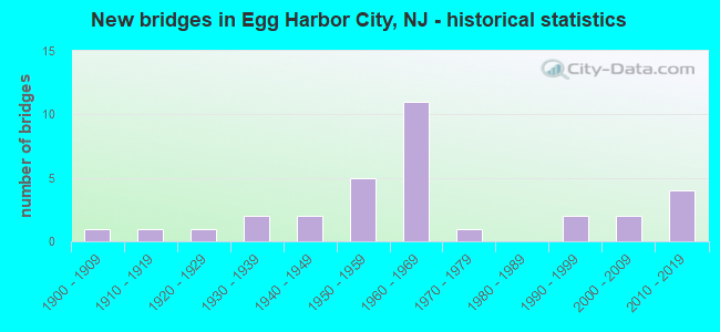
- New bridges - historical statistics
- 11900-1909
- 11910-1919
- 11920-1929
- 21930-1939
- 21940-1949
- 51950-1959
- 111960-1969
- 11970-1979
- 21990-1999
- 22000-2009
- 42010-2019
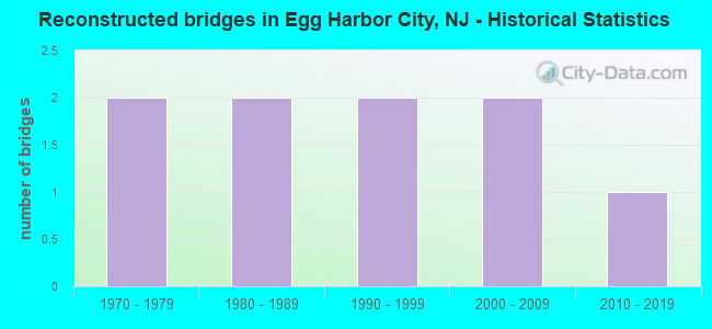
- Reconstructed bridges - Historical Statistics
- 21970-1979
- 21980-1989
- 21990-1999
- 22000-2009
- 12010-2019
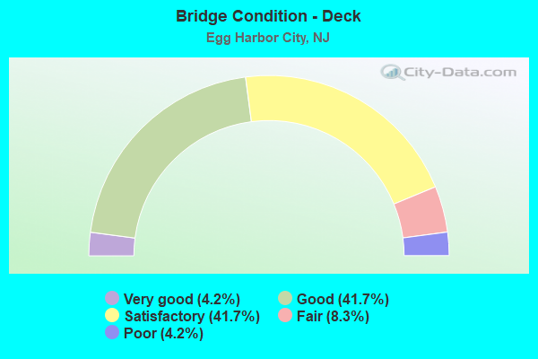
- Bridge Condition - Deck
- 4.2%Very good
- 41.7%Good
- 41.7%Satisfactory
- 8.3%Fair
- 4.2%Poor

- Bridge Condition - Superstructure
- 8.3%Excellent
- 4.2%Very good
- 33.3%Good
- 37.5%Satisfactory
- 8.3%Fair
- 4.2%Poor
- 4.2%Serious
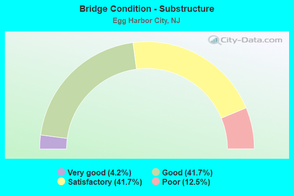
- Bridge Condition - Substructure
- 4.2%Very good
- 41.7%Good
- 41.7%Satisfactory
- 12.5%Poor
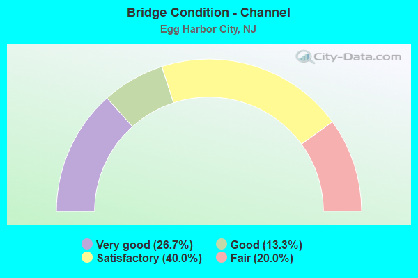
- Bridge Condition - Channel
- 26.7%Very good
- 13.3%Good
- 40.0%Satisfactory
- 20.0%Fair
Find on map >> Show street view
Structure Number: 1EHC06, Location: 0.63 MI E OF CR 563 (Lat: 39.580061, Lng: -74.580981), Route carried "on" structure: County highway 624, Year Built: 1938, Status: Open, Structure Length: 0.88m (2.89ft), Average Daily Traffic: 483 (year 2021), Truck Traffic: 3%, Average Future Daily Traffic: 580 (year 2041), Design Load: H 20, Features Intersected: LANDING CREEK, Facility Carried by Structure: CLARKS LANDING RD
Minimum Vertical Clearance: 30+ m (98+ ft), Kilometerpoint: 1.014, Lanes on structure: 2, Owner: County Highway Agency, Approaching Roadway Width: 9.1m (29.9ft), Material/Design: Steel, Design/Construction: Stringer/Multi-beam, Number Of Spans In Main Unit: 1, Length of Maximum Span: 7.9m (25.9ft), Curb-To-Curb Width: 9.3m (30.5ft), Out-to-Out Width: 10.3m (33.8ft)
Condition: Deck: Good, Superstructure: Satisfactory, Substructure: Poor, Channel: Fair, Inventory Rating: 60.8 metric tons, Method Used To Determine Inventory Rating: Load Factor (LF), Structural Evaluation: Meets minimum limits, Deck Geometry: Equal to present minimum criteria, Waterway Adequacy: Equal to present desirable criteria, Approach Roadway Alignment: Equal to present desirable criteria, Length Of Structure Improvement: 0.88m (2.89ft), Designated Inspection Frequency: Every 24 months, Underwater Inspection Frequency: Every 24 months, Inspection Date: January 2021, Underwater Inspection Date: Febuary 2021, Bridge Improvement Cost: $34,000, Total Project Cost: $156,000 ( Estimate for 2021), Deck Structure Type: Concrete Cast-file-Place, Wearing Surface/Protective System: Wearing Surface: Bituminous
Find on map >> Show street view
Structure Number: 1EHC08, Location: 2.1 mi North CR 561 (Lat: 39.560139, Lng: -74.611111), Route carried "on" structure: County highway 563, Year Built: 1919, Status: Open, Structure Length: 0.79m (2.59ft), Average Daily Traffic: 2,447 (year 2021), Truck Traffic: 3%, Average Future Daily Traffic: 2,936 (year 2041), Design Load: HS 20, Features Intersected: INDIAN CABIN CREEK
Minimum Vertical Clearance: 30+ m (98+ ft), Kilometerpoint: 31.559, Lanes on structure: 2, Owner: County Highway Agency, Approaching Roadway Width: 9.1m (29.9ft), Material/Design: Steel, Design/Construction: Stringer/Multi-beam, Number Of Spans In Main Unit: 1, Length of Maximum Span: 7.3m (24.0ft), Curb-To-Curb Width: 9.1m (29.9ft), Out-to-Out Width: 9.9m (32.5ft)
Condition: Deck: Satisfactory, Superstructure: Fair, Substructure: Poor, Channel: Satisfactory, Operating Rating: 62.6 metric tons, Method Used To Determine Operating Rating: Load Factor (LF), Inventory Rating: 37.2 metric tons, Method Used To Determine Inventory Rating: Load Factor (LF), Structural Evaluation: Meets minimum limits, Deck Geometry: Meets minimum limits, Waterway Adequacy: Equal to present minimum criteria, Approach Roadway Alignment: Equal to present desirable criteria, Length Of Structure Improvement: 0.79m (2.59ft), Designated Inspection Frequency: Every 24 months, Underwater Inspection Frequency: Every 24 months, Inspection Date: January 2021, Underwater Inspection Date: March 2021, Bridge Improvement Cost: $86,000, Total Project Cost: $86,000 ( Estimate for 2021), Deck Structure Type: Concrete Cast-file-Place, Wearing Surface/Protective System: Wearing Surface: Bituminous
Find on map >> Show street view
Structure Number: 1EHC1, Location: 0.4 MI EAST CR 563 (Lat: 39.556850, Lng: -74.603100), Route carried "on" structure: City street , Year Built: 1936, Year Reconstructed: 1983, Status: Open, Structure Length: 0.76m (2.49ft), Average Daily Traffic: 52 (year 2021), Truck Traffic: 3%, Average Future Daily Traffic: 62 (year 2041), Design Load: H 15, Features Intersected: UNION CREEK, Facility Carried by Structure: INDIAN CABIN RD
Minimum Vertical Clearance: 30+ m (98+ ft), Kilometerpoint: 0.000, Lanes on structure: 2, Owner: County Highway Agency, Approaching Roadway Width: 5.5m (18.0ft), Material/Design: Steel, Design/Construction: Stringer/Multi-beam, Number Of Spans In Main Unit: 1, Length of Maximum Span: 7.0m (23.0ft), Curb-To-Curb Width: 5.9m (19.4ft), Out-to-Out Width: 6.1m (20.0ft)
Condition: Deck: Fair, Superstructure: Satisfactory, Substructure: Good, Channel: Satisfactory, Operating Rating: 37.2 metric tons, Method Used To Determine Operating Rating: Load Factor (LF), Inventory Rating: 22.7 metric tons, Method Used To Determine Inventory Rating: Load Factor (LF), Structural Evaluation: Equal to present minimum criteria, Deck Geometry: Meets minimum limits, Waterway Adequacy: Equal to present desirable criteria, Approach Roadway Alignment: Equal to present desirable criteria, Length Of Structure Improvement: 0.76m (2.49ft), Designated Inspection Frequency: Every 24 months, Inspection Date: January 2021, Bridge Improvement Cost: $34,000, Total Project Cost: $34,000 ( Estimate for 2021), Deck Structure Type: Wood or Timber
Find on map >> Show street view
Structure Number: 1EHC17, Location: 0.58 MI N OF US30 & NJ50 (Lat: 39.536500, Lng: -74.642469), Route carried "on" structure: City street , Year Built: 1906, Status: Posted for load, Structure Length: 0.70m (2.30ft), Average Daily Traffic: 1,041 (year 2021), Truck Traffic: 1%, Average Future Daily Traffic: 1,249 (year 2041), Features Intersected: LANDING CREEK, Facility Carried by Structure: LONDON AVE
Minimum Vertical Clearance: 30+ m (98+ ft), Kilometerpoint: 0.000, Lanes on structure: 2, Owner: County Highway Agency, Approaching Roadway Width: 11.0m (36.1ft), Material/Design: Steel, Design/Construction: Stringer/Multi-beam, Number Of Spans In Main Unit: 1, Length of Maximum Span: 6.4m (21.0ft), Curb or Sidewalk Widths: Left: 1.2m (3.9ft), Right: 0.0m, Curb-To-Curb Width: 7.7m (25.3ft), Out-to-Out Width: 8.3m (27.2ft)
Condition: Deck: Satisfactory, Superstructure: Fair, Substructure: Good, Channel: Very good, Operating Rating: 26.3 metric tons, Method Used To Determine Operating Rating: Load Factor (LF), Inventory Rating: 15.4 metric tons, Method Used To Determine Inventory Rating: Load Factor (LF), Structural Evaluation: Meets minimum limits, Deck Geometry: Meets minimum limits, Waterway Adequacy: Superior to present desirable criteria, Approach Roadway Alignment: Equal to present desirable criteria, Bridge Posting: Required (Relationship of Operating Rating to Maximum Legal Load: 0.1 - 9.9% below), Designated Inspection Frequency: Every 24 months, Other Special Inspection Frequency: Every 12 months, Inspection Date: January 2021, Other Special Inspection Date: January 2022, Deck Structure Type: Concrete Cast-file-Place, Wearing Surface/Protective System: Wearing Surface: Bituminous
Find on map >> Show street view
Structure Number: 1EHC39, Location: 0.4 MI EAST CR 563 (Lat: 39.558600, Lng: -74.604889), Route carried "on" structure: City street , Year Built: 1941, Year Reconstructed: 1975, Status: Posted for load, Structure Length: 0.70m (2.30ft), Average Daily Traffic: 124 (year 2021), Truck Traffic: 3%, Average Future Daily Traffic: 149 (year 2041), Features Intersected: INDIAN CABIN CREEK, Facility Carried by Structure: INDIAN CABIN ROAD
Minimum Vertical Clearance: 30+ m (98+ ft), Kilometerpoint: 0.000, Lanes on structure: 2, Owner: County Highway Agency, Approaching Roadway Width: 9.1m (29.9ft), Material/Design: Steel, Design/Construction: Stringer/Multi-beam, Number Of Spans In Main Unit: 1, Length of Maximum Span: 6.7m (22.0ft), Curb-To-Curb Width: 9.4m (30.8ft), Out-to-Out Width: 9.8m (32.2ft)
Condition: Deck: Satisfactory, Superstructure: Satisfactory, Substructure: Satisfactory, Channel: Good, Operating Rating: 17.2 metric tons, Method Used To Determine Operating Rating: Load Factor (LF), Inventory Rating: 10.0 metric tons, Method Used To Determine Inventory Rating: Load Factor (LF), Structural Evaluation: High priority of replacement, Deck Geometry: Equal to present minimum criteria, Waterway Adequacy: Somewhat better than minimum adequacy, Approach Roadway Alignment: Better than present minimum criteria, Bridge Posting: Required (Relationship of Operating Rating to Maximum Legal Load: > 39.9% below), Length Of Structure Improvement: 1.31m (4.30ft), Designated Inspection Frequency: Every 24 months, Other Special Inspection Frequency: Every 12 months, Inspection Date: January 2021, Other Special Inspection Date: January 2022, Bridge Improvement Cost: $702,000, Roadway Improvement Cost: $141,000, Total Project Cost: $1,222,000 ( Estimate for 2021), Deck Structure Type: Wood or Timber, Wearing Surface/Protective System: Wearing Surface: Wood or Timber
Find on map >> Show street view
Structure Number: 1G0018, Location: 2.77 MI N OF CR 561A (Lat: 39.550350, Lng: -74.577250), Route carried "on" structure: City street , Year Built: 1996, Status: Open, Structure Length: 1.01m (3.31ft), Average Daily Traffic: 121 (year 2021), Truck Traffic: 3%, Average Future Daily Traffic: 145 (year 2041), Design Load: HS 20+Mod, Features Intersected: RUBINS RUN, Facility Carried by Structure: FRANKFURT AVENUE
Minimum Vertical Clearance: 30+ m (98+ ft), Kilometerpoint: 0.000, Lanes on structure: 2, Owner: County Highway Agency, Approaching Roadway Width: 6.1m (20.0ft), Material/Design: Wood or Timber, Design/Construction: Stringer/Multi-beam, Number Of Spans In Main Unit: 2, Length of Maximum Span: 4.6m (15.1ft), Curb-To-Curb Width: 7.2m (23.6ft), Out-to-Out Width: 8.5m (27.9ft)
Condition: Deck: Satisfactory, Superstructure: Good, Substructure: Good, Channel: Satisfactory, Operating Rating: 43.5 metric tons, Method Used To Determine Operating Rating: Allowable Stress (AS), Inventory Rating: 31.8 metric tons, Method Used To Determine Inventory Rating: Allowable Stress (AS), Structural Evaluation: Better than present minimum criteria, Deck Geometry: Meets minimum limits, Waterway Adequacy: Better than present minimum criteria, Approach Roadway Alignment: Equal to present desirable criteria, Designated Inspection Frequency: Every 24 months, Inspection Date: January 2021, Deck Structure Type: Wood or Timber
Find on map >> Show street view
Structure Number: 1HML67, Location: 1.4 MI N. of CR 614 (Lat: 39.491150, Lng: -74.658211), Route carried "on" structure: City street , Year Built: 1949, Year Reconstructed: 1998, Status: Open, Structure Length: 0.76m (2.49ft), Average Daily Traffic: 233 (year 2021), Truck Traffic: 3%, Average Future Daily Traffic: 280 (year 2041), Design Load: HS 20+Mod, Features Intersected: BABCOCK CREEK, Facility Carried by Structure: HOLLY AVENUE
Minimum Vertical Clearance: 30+ m (98+ ft), Kilometerpoint: 0.000, Lanes on structure: 2, Owner: County Highway Agency, Approaching Roadway Width: 7.6m (24.9ft), Material/Design: Wood or Timber, Design/Construction: Stringer/Multi-beam, Number Of Spans In Main Unit: 2, Length of Maximum Span: 3.0m (9.8ft), Curb-To-Curb Width: 7.2m (23.6ft), Out-to-Out Width: 8.6m (28.2ft)
Condition: Deck: Fair, Superstructure: Good, Substructure: Good, Channel: Satisfactory, Operating Rating: 48.1 metric tons, Method Used To Determine Operating Rating: Allowable Stress (AS), Inventory Rating: 36.3 metric tons, Method Used To Determine Inventory Rating: Allowable Stress (AS), Structural Evaluation: Better than present minimum criteria, Deck Geometry: Meets minimum limits, Waterway Adequacy: Better than present minimum criteria, Approach Roadway Alignment: Equal to present desirable criteria, Designated Inspection Frequency: Every 24 months, Inspection Date: Febuary 2021, Deck Structure Type: Wood or Timber
Find on map >> Show street view
Structure Number: 1M0001, Location: 0.08 Miles S. of River Rd (Lat: 39.611419, Lng: -74.589289), Route carried "on" structure: County highway 563, Year Built: 2003, Status: Open, Structure Length: 7.32m (24.02ft), Average Daily Traffic: 797 (year 2021), Truck Traffic: 3%, Average Future Daily Traffic: 956 (year 2041), Design Load: H 20, Features Intersected: MULLICA RIVER, Facility Carried by Structure: EGG HRBR-GRN BNK R
Minimum Vertical Clearance: 4.70m (15.42ft), Kilometerpoint: 38.930, Lanes on structure: 2, Owner: County Highway Agency, Approaching Roadway Width: 7.0m (23.0ft), Navigation Control: Yes ( Vertical Clearance: 1.5m (4.9ft), Horizontal Clearance: 9.1m (29.9ft)), Material/Design: Steel, Design/Construction: Movable - Bascule, Number Of Spans In Main Unit: 1, Number Of Approach Spans: 8, Length of Maximum Span: 12.2m (40.0ft), Curb-To-Curb Width: 7.0m (23.0ft), Out-to-Out Width: 8.1m (26.6ft)
Condition: Deck: Good, Superstructure: Good, Substructure: Good, Channel: Very good, Operating Rating: 39.0 metric tons, Method Used To Determine Operating Rating: Allowable Stress (AS), Inventory Rating: 26.3 metric tons, Method Used To Determine Inventory Rating: Allowable Stress (AS), Structural Evaluation: Equal to present minimum criteria, Deck Geometry: Meets minimum limits, Waterway Adequacy: Equal to present desirable criteria, Approach Roadway Alignment: Equal to present desirable criteria, Designated Inspection Frequency: Every 24 months, Critical Feature Inspection Frequency: Every 24 months, Underwater Inspection Frequency: Every 48 months, Inspection Date: Febuary 2021, Critical Feature Inspection Date: Febuary 2021, Underwater Inspection Date: Febuary 2021, Deck Structure Type: Open Grating, Wearing Surface/Protective System: Wearing Surface: Bituminous
Find on map >> Show street view
Structure Number: 1M0002, Location: 0.57 MI SOUTH OF (CR542) (Lat: 39.611350, Lng: -74.589339), Route carried "on" structure: County highway 563, Year Built: 2003, Status: Open, Structure Length: 0.91m (2.99ft), Average Daily Traffic: 797 (year 2021), Truck Traffic: 3%, Average Future Daily Traffic: 956 (year 2041), Design Load: HS 20+Mod, Features Intersected: MULLICA RIVER, Facility Carried by Structure: EGG HRBR-GRN BANK
Minimum Vertical Clearance: 30+ m (98+ ft), Kilometerpoint: 38.882, Lanes on structure: 2, Owner: County Highway Agency, Approaching Roadway Width: 7.0m (23.0ft), Material/Design: Wood or Timber, Design/Construction: Slab, Number Of Spans In Main Unit: 1, Length of Maximum Span: 7.6m (24.9ft), Curb-To-Curb Width: 7.0m (23.0ft), Out-to-Out Width: 8.1m (26.6ft)
Condition: Deck: Good, Superstructure: Satisfactory, Substructure: Satisfactory, Channel: Very good, Operating Rating: 39.0 metric tons, Method Used To Determine Operating Rating: Allowable Stress (AS), Inventory Rating: 26.3 metric tons, Method Used To Determine Inventory Rating: Allowable Stress (AS), Structural Evaluation: Equal to present minimum criteria, Deck Geometry: Meets minimum limits, Waterway Adequacy: Equal to present minimum criteria, Approach Roadway Alignment: Equal to present desirable criteria, Designated Inspection Frequency: Every 24 months, Underwater Inspection Frequency: Every 48 months, Inspection Date: Febuary 2021, Underwater Inspection Date: Febuary 2021, Deck Structure Type: Wood or Timber, Wearing Surface/Protective System: Wearing Surface: Bituminous, Membrane: Preformed Fabric
Find on map >> Show street view
Structure Number: 3F83, Location: 0.08 M. W. OF C.R. 651 (Lat: 39.617939, Lng: -74.596000), Route carried "on" structure: County highway 542, Year Built: 1976, Status: Open, Structure Length: 1.22m (4.00ft), Average Daily Traffic: 2,397 (year 2021), Truck Traffic: 3%, Average Future Daily Traffic: 2,876 (year 2041), Design Load: HS 20+Mod, Features Intersected: W.BR. BULL CREEK
Minimum Vertical Clearance: 30+ m (98+ ft), Kilometerpoint: 19.586, Lanes on structure: 2, Owner: County Highway Agency, Approaching Roadway Width: 9.8m (32.2ft), Material/Design: Prestressed concrete, Design/Construction: Slab, Number Of Spans In Main Unit: 1, Length of Maximum Span: 11.6m (38.1ft), Curb-To-Curb Width: 9.8m (32.2ft), Out-to-Out Width: 10.8m (35.4ft)
Condition: Deck: Poor, Superstructure: Poor, Substructure: Satisfactory, Channel: Fair, Operating Rating: 42.6 metric tons, Method Used To Determine Operating Rating: Load Factor (LF), Inventory Rating: 20.0 metric tons, Method Used To Determine Inventory Rating: Load Factor (LF), Structural Evaluation: Meets minimum limits, Deck Geometry: Meets minimum limits, Waterway Adequacy: Superior to present desirable criteria, Approach Roadway Alignment: Better than present minimum criteria, Length Of Structure Improvement: 1.22m (4.00ft), Designated Inspection Frequency: Every 24 months, Inspection Date: October 2021, Bridge Improvement Cost: $480,000, Roadway Improvement Cost: $40,000, Total Project Cost: $856,000 ( Estimate for 2021), Deck Structure Type: Concrete Precast Panels, Wearing Surface/Protective System: Wearing Surface: Bituminous, Membrane: Preformed Fabric
Find on map >> Show street view
Structure Number: 3G8045, Location: 1.79 MI SW OF CR 542 (Lat: 39.593219, Lng: -74.552150), Route carried "on" structure: County highway 652, Year Built: 1993, Status: Open, Structure Length: 14.20m (46.59ft), Average Daily Traffic: 777 (year 2021), Truck Traffic: 5%, Average Future Daily Traffic: 932 (year 2041), Design Load: HS 20+Mod, Features Intersected: MULLICA RIVER
Minimum Vertical Clearance: 4.75m (15.58ft), Kilometerpoint: 0.000, Lanes on structure: 2, Owner: County Highway Agency, Approaching Roadway Width: 9.1m (29.9ft), Navigation Control: Yes ( Vertical Clearance: 3.0m (9.8ft), Horizontal Clearance: 9.1m (29.9ft)), Material/Design: Steel, Design/Construction: Movable - Bascule, Number Of Spans In Main Unit: 1, Number Of Approach Spans: 6, Length of Maximum Span: 22.3m (73.2ft), Curb-To-Curb Width: 9.1m (29.9ft), Out-to-Out Width: 10.2m (33.5ft)
Condition: Deck: Good, Superstructure: Good, Substructure: Good, Channel: Very good, Operating Rating: 69.9 metric tons, Method Used To Determine Operating Rating: Load Factor (LF), Inventory Rating: 41.7 metric tons, Method Used To Determine Inventory Rating: Load Factor (LF), Structural Evaluation: Better than present minimum criteria, Deck Geometry: Equal to present minimum criteria, Waterway Adequacy: Equal to present desirable criteria, Approach Roadway Alignment: Equal to present desirable criteria, Designated Inspection Frequency: Every 24 months, Critical Feature Inspection Frequency: Every 24 months, Underwater Inspection Frequency: Every 48 months, Inspection Date: October 2021, Critical Feature Inspection Date: October 2021, Underwater Inspection Date: December 2021, Deck Structure Type: Concrete Cast-file-Place, Wearing Surface/Protective System: Wearing Surface: Monolithic Concrete, Deck Protection: Epoxy Coated Reinforcing
Find on map >> Show street view
Structure Number: 3H8001, Location: 0.1 MI W of CR542&653 JCT (Lat: 39.617211, Lng: -74.497139), Route carried "on" structure: County highway 542, Year Built: 1928, Year Reconstructed: 2001, Status: Open, Structure Length: 12.22m (40.09ft), Average Daily Traffic: 3,193 (year 2021), Truck Traffic: 3%, Average Future Daily Traffic: 3,832 (year 2041), Design Load: HS 20, Features Intersected: WADING RIVER
Minimum Vertical Clearance: 4.69m (15.39ft), Kilometerpoint: 28.341, Lanes on structure: 2, Owner: County Highway Agency, Approaching Roadway Width: 7.3m (24.0ft), Navigation Control: Yes ( Vertical Clearance: 1.8m (5.9ft), Horizontal Clearance: 9.1m (29.9ft)), Material/Design: Steel, Design/Construction: Movable - Bascule, Number Of Spans In Main Unit: 1, Number Of Approach Spans: 30, Length of Maximum Span: 12.5m (41.0ft), Curb or Sidewalk Widths: Left: 1.8m (5.9ft), Right: 1.8m (5.9ft), Curb-To-Curb Width: 7.3m (24.0ft), Out-to-Out Width: 8.8m (28.9ft)
Condition: Deck: Satisfactory, Superstructure: Serious, Substructure: Poor, Channel: Good, Operating Rating: 32.7 metric tons, Method Used To Determine Operating Rating: Load Factor (LF), Inventory Rating: 19.1 metric tons, Method Used To Determine Inventory Rating: Load Factor (LF), Structural Evaluation: High priority of corrective action, Deck Geometry: High priority of replacement, Waterway Adequacy: Equal to present desirable criteria, Approach Roadway Alignment: Equal to present minimum criteria, Length Of Structure Improvement: 12.22m (40.09ft), Designated Inspection Frequency: Every 24 months, Critical Feature Inspection Frequency: Every 24 months, Underwater Inspection Frequency: Every 48 months, Other Special Inspection Frequency: Every 12 months, Inspection Date: October 2021, Critical Feature Inspection Date: October 2021, Underwater Inspection Date: December 2021, Other Special Inspection Date: October 2021, Bridge Improvement Cost: $8,351,000, Roadway Improvement Cost: $835,000, Total Project Cost: $10,991,000 ( Estimate for 2021), Deck Structure Type: Closed Grating, Wearing Surface/Protective System: Wearing Surface: Latex Concrete
Find on map >> Show street view
Structure Number: 350135, Location: 2.25 MI N OF ACE&RT575 JC (Lat: 39.471669, Lng: -74.633331), Route carried "on" structure: County highway 670, Year Built: 1964, Status: Open, Structure Length: 6.19m (20.31ft), Average Daily Traffic: 1,500 (year 2006), Truck Traffic: 5%, Average Future Daily Traffic: 2,200 (year 2026), Design Load: HS 20+Mod, Features Intersected: ATLANTIC CITY EXPRESSWAY, Facility Carried by Structure: LEIPZIG AVENUE
Minimum Vertical Clearance: 30+ m (98+ ft), Kilometerpoint: 16.093, Lanes on structure: 2, Lanes under structure: 5, Owner: State Toll Authority, Maintenance Responsibility: Private, Approaching Roadway Width: 14.6m (47.9ft), Skew: 3 degrees, Material/Design: Steel, Design/Construction: Stringer/Multi-beam, Number Of Spans In Main Unit: 4, Length of Maximum Span: 21.3m (69.9ft), Curb or Sidewalk Widths: Left: 0.5m (1.6ft), Right: 1.2m (3.9ft), Curb-To-Curb Width: 14.6m (47.9ft), Out-to-Out Width: 17.1m (56.1ft)
Condition: Deck: Good, Superstructure: Satisfactory, Substructure: Satisfactory, Operating Rating: 89.8 metric tons, Method Used To Determine Operating Rating: Load Factor (LF), Inventory Rating: 60.8 metric tons, Method Used To Determine Inventory Rating: Load Factor (LF), Structural Evaluation: Equal to present minimum criteria, Deck Geometry: Superior to present desirable criteria, Underclear: High priority of corrective action, Approach Roadway Alignment: Equal to present desirable criteria, Length Of Structure Improvement: 6.20m (20.34ft), Designated Inspection Frequency: Every 24 months, Inspection Date: March 2020, Deck Structure Type: Concrete Cast-file-Place, Wearing Surface/Protective System: Wearing Surface: Monolithic Concrete
Find on map >> Show street view
Structure Number: 350139, Location: 0.1 MI E. OF COLOGNE AVE (Lat: 39.486669, Lng: -74.635000), Route carried "on" structure: Other road ACE, Year Built: 1963, Year Reconstructed: 1987, Status: Open, Structure Length: 0.73m (2.40ft), Average Daily Traffic: 53,357 (year 2012), Truck Traffic: 7%, Average Future Daily Traffic: 77,175 (year 2032), Design Load: HS 20, Features Intersected: JACK PUDDING BRANCH, Facility Carried by Structure: A.C. EXPRESSWAY
Minimum Vertical Clearance: 30+ m (98+ ft), Kilometerpoint: 22.370, Lanes on structure: 7, Base Highway Network: Yes, Toll: On toll road, Owner: State Toll Authority, Maintenance Responsibility: Private, Approaching Roadway Width: 46.6m (152.9ft), Skew: 30 degrees, Material/Design: Concrete, Design/Construction: Slab, Number Of Spans In Main Unit: 1, Length of Maximum Span: 6.1m (20.0ft), Curb or Sidewalk Widths: Left: 0.5m (1.6ft), Right: 0.5m (1.6ft), Curb-To-Curb Width: 46.6m (152.9ft), Out-to-Out Width: 49.1m (161.1ft)
Condition: Deck: Satisfactory, Superstructure: Satisfactory, Substructure: Satisfactory, Channel: Satisfactory, Operating Rating: 58.1 metric tons, Method Used To Determine Operating Rating: Load Factor (LF), Inventory Rating: 35.4 metric tons, Method Used To Determine Inventory Rating: Load Factor (LF), Structural Evaluation: Equal to present minimum criteria, Deck Geometry: Superior to present desirable criteria, Waterway Adequacy: Equal to present desirable criteria, Approach Roadway Alignment: Better than present minimum criteria, Designated Inspection Frequency: Every 24 months, Inspection Date: March 2020, Deck Structure Type: Concrete Cast-file-Place, Wearing Surface/Protective System: Wearing Surface: Bituminous
Find on map >> Show street view
Structure Number: 35014, Location: 1.7 MI N OF ACE&RT575 JCT (Lat: 39.478331, Lng: -74.638331), Route carried "on" structure: County highway 614, Year Built: 1964, Status: Open, Structure Length: 5.43m (17.81ft), Average Daily Traffic: 1,360 (year 2012), Truck Traffic: 5%, Average Future Daily Traffic: 1,917 (year 2032), Design Load: HS 20+Mod, Features Intersected: ATLANTIC CITY EXPRESSWAY, Facility Carried by Structure: COLOGNE AVENUE
Minimum Vertical Clearance: 30+ m (98+ ft), Kilometerpoint: 4.474, Lanes on structure: 2, Lanes under structure: 6, Owner: State Toll Authority, Maintenance Responsibility: Private, Approaching Roadway Width: 10.4m (34.1ft), Skew: 1 degrees, Material/Design: Prestressed concrete, Design/Construction: Stringer/Multi-beam, Number Of Spans In Main Unit: 4, Length of Maximum Span: 19.8m (65.0ft), Curb or Sidewalk Widths: Left: 1.2m (3.9ft), Right: 0.5m (1.6ft), Curb-To-Curb Width: 10.4m (34.1ft), Out-to-Out Width: 12.8m (42.0ft)
Condition: Deck: Satisfactory, Superstructure: Satisfactory, Substructure: Satisfactory, Operating Rating: 70.8 metric tons, Method Used To Determine Operating Rating: Load Factor (LF), Inventory Rating: 42.6 metric tons, Method Used To Determine Inventory Rating: Load Factor (LF), Structural Evaluation: Equal to present minimum criteria, Deck Geometry: Equal to present minimum criteria, Underclear: Meets minimum limits, Approach Roadway Alignment: Better than present minimum criteria, Designated Inspection Frequency: Every 24 months, Inspection Date: March 2020, Deck Structure Type: Concrete Cast-file-Place, Wearing Surface/Protective System: Wearing Surface: Monolithic Concrete
Find on map >> Show street view
Structure Number: 350153N, Location: 1.5 MI SE OF ACE&RT50 JCT (Lat: 39.491669, Lng: -74.655000), Route carried "on" structure: Other road ACE, Year Built: 1964, Status: Open, Structure Length: 1.46m (4.79ft), Average Daily Traffic: 24,000 (year 2006), Truck Traffic: 7%, Average Future Daily Traffic: 37,200 (year 2026), Design Load: HS 20, Features Intersected: BABCOCK CREEK, Facility Carried by Structure: A.C. EXPRESSWAY WB
Minimum Vertical Clearance: 30+ m (98+ ft), Kilometerpoint: 24.623, Lanes on structure: 3, Base Highway Network: Yes, Toll: On toll road, Owner: State Toll Authority, Maintenance Responsibility: Private, Approaching Roadway Width: 14.6m (47.9ft), Material/Design: Prestressed concrete, Design/Construction: Stringer/Multi-beam, Number Of Spans In Main Unit: 1, Length of Maximum Span: 12.2m (40.0ft), Curb or Sidewalk Widths: Left: 0.5m (1.6ft), Right: 0.5m (1.6ft), Curb-To-Curb Width: 16.5m (54.1ft), Out-to-Out Width: 17.7m (58.1ft)
Condition: Deck: Good, Superstructure: Good, Substructure: Satisfactory, Channel: Satisfactory, Operating Rating: 67.1 metric tons, Method Used To Determine Operating Rating: Load Factor (LF), Inventory Rating: 40.8 metric tons, Method Used To Determine Inventory Rating: Load Factor (LF), Structural Evaluation: Equal to present minimum criteria, Deck Geometry: Better than present minimum criteria, Waterway Adequacy: Equal to present desirable criteria, Approach Roadway Alignment: Better than present minimum criteria, Designated Inspection Frequency: Every 24 months, Inspection Date: March 2020, Deck Structure Type: Concrete Cast-file-Place, Wearing Surface/Protective System: Wearing Surface: Bituminous
Find on map >> Show street view
Structure Number: 350153S, Location: 1.5 MI SE OF ACE&RT50 JCT (Lat: 39.491669, Lng: -74.656669), Route carried "on" structure: Other road ACE, Year Built: 1963, Year Reconstructed: 1987, Status: Open, Structure Length: 1.40m (4.59ft), Average Daily Traffic: 24,000 (year 2006), Truck Traffic: 7%, Average Future Daily Traffic: 33,300 (year 2026), Design Load: HS 20, Features Intersected: BABCOCK CREEK, Facility Carried by Structure: A.C. EXPRESSWAY EB
Minimum Vertical Clearance: 30+ m (98+ ft), Kilometerpoint: 24.623, Lanes on structure: 3, Base Highway Network: Yes, Toll: On toll road, Owner: State Toll Authority, Maintenance Responsibility: Private, Approaching Roadway Width: 16.2m (53.1ft), Material/Design: Prestressed concrete, Design/Construction: Stringer/Multi-beam, Number Of Spans In Main Unit: 1, Length of Maximum Span: 12.2m (40.0ft), Curb or Sidewalk Widths: Left: 0.0m, Right: 0.5m (1.6ft), Curb-To-Curb Width: 16.1m (52.8ft), Out-to-Out Width: 17.4m (57.1ft)
Condition: Deck: Good, Superstructure: Good, Substructure: Satisfactory, Channel: Fair, Operating Rating: 67.1 metric tons, Method Used To Determine Operating Rating: Load Factor (LF), Inventory Rating: 40.8 metric tons, Method Used To Determine Inventory Rating: Load Factor (LF), Structural Evaluation: Equal to present minimum criteria, Deck Geometry: Better than present minimum criteria, Waterway Adequacy: Equal to present desirable criteria, Approach Roadway Alignment: Equal to present desirable criteria, Designated Inspection Frequency: Every 24 months, Inspection Date: March 2020, Deck Structure Type: Concrete Cast-file-Place, Wearing Surface/Protective System: Wearing Surface: Bituminous
Find on map >> Show street view
Structure Number: 350168N, Location: 2.75 MI NE OF RT50&322 JC (Lat: 39.506669, Lng: -74.676669), Route carried "on" structure: Other road ACE, Year Built: 1963, Year Reconstructed: 2009, Status: Open, Structure Length: 5.58m (18.31ft), Average Daily Traffic: 24,000 (year 2006), Truck Traffic: 7%, Average Future Daily Traffic: 33,300 (year 2026), Design Load: HS 20+Mod, Features Intersected: ROUTE 50
Minimum Vertical Clearance: 30+ m (98+ ft), Kilometerpoint: 27.037, Lanes on structure: 3, Lanes under structure: 4, Base Highway Network: Yes, Toll: On toll road, Owner: State Toll Authority, Maintenance Responsibility: Private, Approaching Roadway Width: 14.6m (47.9ft), Material/Design: Prestressed concrete, Design/Construction: Stringer/Multi-beam, Number Of Spans In Main Unit: 4, Length of Maximum Span: 22.3m (73.2ft), Curb or Sidewalk Widths: Left: 0.0m, Right: 0.5m (1.6ft), Curb-To-Curb Width: 14.3m (46.9ft), Out-to-Out Width: 16.2m (53.1ft)
Condition: Deck: Good, Superstructure: Satisfactory, Substructure: Satisfactory, Operating Rating: 89.8 metric tons, Method Used To Determine Operating Rating: Load Factor (LF), Inventory Rating: 35.4 metric tons, Method Used To Determine Inventory Rating: Load Factor (LF), Structural Evaluation: Equal to present minimum criteria, Deck Geometry: Somewhat better than minimum adequacy, Underclear: Equal to present minimum criteria, Approach Roadway Alignment: Better than present minimum criteria, Designated Inspection Frequency: Every 24 months, Inspection Date: March 2020, Deck Structure Type: Concrete Cast-file-Place, Wearing Surface/Protective System: Wearing Surface: Bituminous
Find on map >> Show street view
Structure Number: 350168S, Location: 2.75 MI NE OF RT50&322 JC (Lat: 39.506669, Lng: -74.676669), Route carried "on" structure: Other road ACE, Year Built: 1963, Year Reconstructed: 2009, Status: Open, Structure Length: 5.58m (18.31ft), Average Daily Traffic: 24,000 (year 2006), Truck Traffic: 7%, Average Future Daily Traffic: 33,300 (year 2026), Design Load: HS 20+Mod, Features Intersected: ROUTE 50
Minimum Vertical Clearance: 30+ m (98+ ft), Kilometerpoint: 27.037, Lanes on structure: 3, Lanes under structure: 4, Base Highway Network: Yes, Toll: On toll road, Owner: State Toll Authority, Maintenance Responsibility: Private, Approaching Roadway Width: 16.8m (55.1ft), Material/Design: Prestressed concrete, Design/Construction: Stringer/Multi-beam, Number Of Spans In Main Unit: 4, Length of Maximum Span: 22.3m (73.2ft), Curb or Sidewalk Widths: Left: 0.0m, Right: 0.5m (1.6ft), Curb-To-Curb Width: 14.9m (48.9ft), Out-to-Out Width: 16.2m (53.1ft)
Condition: Deck: Satisfactory, Superstructure: Satisfactory, Substructure: Satisfactory, Operating Rating: 89.8 metric tons, Method Used To Determine Operating Rating: Load Factor (LF), Inventory Rating: 35.4 metric tons, Method Used To Determine Inventory Rating: Load Factor (LF), Structural Evaluation: Equal to present minimum criteria, Deck Geometry: Equal to present minimum criteria, Underclear: Equal to present minimum criteria, Approach Roadway Alignment: Better than present minimum criteria, Designated Inspection Frequency: Every 24 months, Inspection Date: March 2020, Deck Structure Type: Concrete Cast-file-Place, Wearing Surface/Protective System: Wearing Surface: Bituminous
Find on map >> Show street view
Structure Number: 360335N, Location: 4 MI N OF RT 52 CIRCLE (Lat: 39.367528, Lng: -74.584486), Route carried "on" structure: Other road GSP, Year Built: 1954, Status: Open, Structure Length: 1.58m (5.18ft), Average Daily Traffic: 22,800 (year 2021), Truck Traffic: 3%, Average Future Daily Traffic: 27,850 (year 2041), Design Load: HS 20, Features Intersected: ZION RD (CR 615)
Minimum Vertical Clearance: 30+ m (98+ ft), Kilometerpoint: 53.993, Lanes on structure: 2, Lanes under structure: 2, Base Highway Network: Yes, Toll: On toll road, Owner: State Toll Authority, Approaching Roadway Width: 12.8m (42.0ft), Skew: 2 degrees, Material/Design: Prestressed concrete, Design/Construction: Stringer/Multi-beam, Number Of Spans In Main Unit: 1, Length of Maximum Span: 15.2m (49.9ft), Curb-To-Curb Width: 12.4m (40.7ft), Out-to-Out Width: 13.5m (44.3ft)
Condition: Deck: Satisfactory, Superstructure: Good, Substructure: Good, Operating Rating: 33.4 metric tons, Method Used To Determine Operating Rating: Load and Resistance Factor Rating (LRFR) rating reported by rating factor(RF) method using HL-93 loadings, Inventory Rating: 25.9 metric tons, Method Used To Determine Inventory Rating: Load and Resistance Factor Rating (LRFR) rating reported by rating factor(RF) method using HL-93 loadings, Structural Evaluation: Equal to present minimum criteria, Deck Geometry: Better than present minimum criteria, Underclear: Somewhat better than minimum adequacy, Approach Roadway Alignment: Equal to present desirable criteria, Designated Inspection Frequency: Every 24 months, Inspection Date: April 2021, Deck Structure Type: Concrete Cast-file-Place, Wearing Surface/Protective System: Wearing Surface: Bituminous, Membrane: Preformed Fabric
Find on map >> Show street view
Structure Number: 360336S, Location: 4 MI N OF RT 52 CIRCLE (Lat: 39.367431, Lng: -74.585072), Route carried "on" structure: Other road GSP, Year Built: 1954, Status: Open, Structure Length: 1.58m (5.18ft), Average Daily Traffic: 21,800 (year 2021), Truck Traffic: 3%, Average Future Daily Traffic: 26,600 (year 2041), Design Load: HS 20, Features Intersected: ZION RD (CR 615)
Minimum Vertical Clearance: 30+ m (98+ ft), Kilometerpoint: 53.993, Lanes on structure: 2, Lanes under structure: 2, Base Highway Network: Yes, Toll: On toll road, Owner: State Toll Authority, Approaching Roadway Width: 12.8m (42.0ft), Skew: 2 degrees, Material/Design: Prestressed concrete, Design/Construction: Stringer/Multi-beam, Number Of Spans In Main Unit: 1, Length of Maximum Span: 15.2m (49.9ft), Curb-To-Curb Width: 12.4m (40.7ft), Out-to-Out Width: 13.5m (44.3ft)
Condition: Deck: Satisfactory, Superstructure: Good, Substructure: Good, Operating Rating: 33.7 metric tons, Method Used To Determine Operating Rating: Load and Resistance Factor Rating (LRFR) rating reported by rating factor(RF) method using HL-93 loadings, Inventory Rating: 25.9 metric tons, Method Used To Determine Inventory Rating: Load and Resistance Factor Rating (LRFR) rating reported by rating factor(RF) method using HL-93 loadings, Structural Evaluation: Equal to present minimum criteria, Deck Geometry: Better than present minimum criteria, Underclear: Somewhat better than minimum adequacy, Approach Roadway Alignment: Equal to present desirable criteria, Designated Inspection Frequency: Every 24 months, Inspection Date: April 2021, Deck Structure Type: Concrete Cast-file-Place, Wearing Surface/Protective System: Wearing Surface: Bituminous, Membrane: Preformed Fabric
Find on map >> Show street view
Structure Number: 360363T, Location: 1 MI S OF GSP&ACE JCT (Lat: 39.401781, Lng: -74.558592), Route carried "on" structure: Other road GSP, Year Built: 1954, Year Reconstructed: 2015, Status: Open, Structure Length: 1.37m (4.49ft), Average Daily Traffic: 48,020 (year 2021), Truck Traffic: 3%, Average Future Daily Traffic: 58,580 (year 2041), Design Load: HL 93, Features Intersected: PENN-READING SEASHORE RR
Minimum Vertical Clearance: 30+ m (98+ ft), Kilometerpoint: 58.419, Lanes on structure: 8, Base Highway Network: Yes, Toll: On toll road, Owner: State Toll Authority, Approaching Roadway Width: 43.9m (144.0ft), Skew: 30 degrees, Material/Design: Steel, Design/Construction: Stringer/Multi-beam, Number Of Spans In Main Unit: 1, Length of Maximum Span: 11.9m (39.0ft), Curb-To-Curb Width: 43.9m (144.0ft), Out-to-Out Width: 46.0m (150.9ft)
Condition: Deck: Good, Superstructure: Excellent, Substructure: Very good, Operating Rating: 50.5 metric tons, Method Used To Determine Operating Rating: Load and Resistance Factor Rating (LRFR) rating reported by rating factor(RF) method using HL-93 loadings, Inventory Rating: 38.9 metric tons, Method Used To Determine Inventory Rating: Load and Resistance Factor Rating (LRFR) rating reported by rating factor(RF) method using HL-93 loadings, Structural Evaluation: Equal to present desirable criteria, Deck Geometry: Superior to present desirable criteria, Underclear: Somewhat better than minimum adequacy, Approach Roadway Alignment: Superior to present desirable criteria, Designated Inspection Frequency: Every 24 months, Inspection Date: July 2021, Deck Structure Type: Concrete Cast-file-Place, Wearing Surface/Protective System: Wearing Surface: Monolithic Concrete, Deck Protection: Epoxy Coated Reinforcing
Find on map >> Show street view
Structure Number: 370377N, Location: 0.5 MI N OF GSP&ACE JCT (Lat: 39.420031, Lng: -74.548561), Route carried "on" structure: Other road GSP, Year Built: 2015, Status: Open, Structure Length: 2.83m (9.28ft), Average Daily Traffic: 27,900 (year 2021), Truck Traffic: 3%, Average Future Daily Traffic: 34,000 (year 2041), Design Load: HL 93, Features Intersected: DELILAH ROAD (CR 646)
Minimum Vertical Clearance: 30+ m (98+ ft), Kilometerpoint: 60.672, Lanes on structure: 3, Lanes under structure: 2, Base Highway Network: Yes, Toll: On toll road, Owner: State Toll Authority, Approaching Roadway Width: 20.2m (66.3ft), Material/Design: Steel, Design/Construction: Stringer/Multi-beam, Number Of Spans In Main Unit: 1, Length of Maximum Span: 18.6m (61.0ft), Curb or Sidewalk Widths: Left: 2.2m (7.2ft), Right: 0.0m, Curb-To-Curb Width: 20.2m (66.3ft), Out-to-Out Width: 21.3m (69.9ft)
Condition: Deck: Good, Superstructure: Very good, Substructure: Good, Operating Rating: 82.3 metric tons, Method Used To Determine Operating Rating: Load and Resistance Factor Rating (LRFR) rating reported by rating factor(RF) method using HL-93 loadings, Inventory Rating: 63.2 metric tons, Method Used To Determine Inventory Rating: Load and Resistance Factor Rating (LRFR) rating reported by rating factor(RF) method using HL-93 loadings, Structural Evaluation: Better than present minimum criteria, Deck Geometry: Superior to present desirable criteria, Underclear: Equal to present minimum criteria, Approach Roadway Alignment: Superior to present desirable criteria, Designated Inspection Frequency: Every 24 months, Inspection Date: July 2021, Deck Structure Type: Concrete Cast-file-Place, Wearing Surface/Protective System: Wearing Surface: Monolithic Concrete, Deck Protection: Epoxy Coated Reinforcing
Find on map >> Show street view
Structure Number: 370377S, Location: 0.5 MI N OF GSP&ACE JCT (Lat: 39.420411, Lng: -74.549411), Route carried "on" structure: Other road GSP, Year Built: 2015, Status: Open, Structure Length: 1.92m (6.30ft), Average Daily Traffic: 26,200 (year 2021), Truck Traffic: 3%, Average Future Daily Traffic: 31,960 (year 2041), Design Load: HL 93, Features Intersected: DELILAH ROAD (CR 646)
Minimum Vertical Clearance: 30+ m (98+ ft), Kilometerpoint: 60.672, Lanes on structure: 3, Lanes under structure: 2, Base Highway Network: Yes, Toll: On toll road, Owner: State Toll Authority, Approaching Roadway Width: 18.3m (60.0ft), Material/Design: Steel, Design/Construction: Stringer/Multi-beam, Number Of Spans In Main Unit: 1, Length of Maximum Span: 18.6m (61.0ft), Curb-To-Curb Width: 18.3m (60.0ft), Out-to-Out Width: 19.4m (63.6ft)
Condition: Deck: Very good, Superstructure: Excellent, Substructure: Good, Operating Rating: 81.6 metric tons, Method Used To Determine Operating Rating: Load and Resistance Factor Rating (LRFR) rating reported by rating factor(RF) method using HL-93 loadings, Inventory Rating: 62.9 metric tons, Method Used To Determine Inventory Rating: Load and Resistance Factor Rating (LRFR) rating reported by rating factor(RF) method using HL-93 loadings, Structural Evaluation: Better than present minimum criteria, Deck Geometry: Better than present minimum criteria, Underclear: Equal to present minimum criteria, Approach Roadway Alignment: Superior to present desirable criteria, Designated Inspection Frequency: Every 24 months, Inspection Date: July 2021, Deck Structure Type: Concrete Cast-file-Place, Wearing Surface/Protective System: Wearing Surface: Monolithic Concrete, Deck Protection: Epoxy Coated Reinforcing
Find on map >> Show street view
Structure Number: 350135, Location: 2.25 MI N OF ACE&RT575 JC (Lat: 39.471669, Lng: -74.633331), Route carried "under" structure: Other road ACE, Year Built: 1964, Structure Length: 0. m, Average Daily Traffic: 47,900 (year 2006), Truck Traffic: 5%, Features Intersected: ATLANTIC CITY EXPRESSWAY, Facility Carried by Structure: LEIPZIG AVENUE
Minimum Vertical Clearance: 4.47m (14.67ft), Kilometerpoint: 21.726, Lanes on structure: 2, Lanes under structure: 5, Material/Design: Steel, Design/Construction: Stringer/Multi-beam, Length of Maximum Span: 21.3m (69.9ft)
Find on map >> Show street view
Structure Number: 35014, Location: 1.7 MI N OF ACE&RT575 JCT (Lat: 39.478331, Lng: -74.638331), Route carried "under" structure: Other road ACE, Year Built: 1964, Structure Length: 0. m, Average Daily Traffic: 54,327 (year 2012), Truck Traffic: 7%, Features Intersected: ATLANTIC CITY EXPRESSWAY, Facility Carried by Structure: COLOGNE AVENUE
Minimum Vertical Clearance: 4.32m (14.17ft), Kilometerpoint: 22.531, Lanes on structure: 2, Lanes under structure: 6, Material/Design: Prestressed concrete, Design/Construction: Stringer/Multi-beam, Length of Maximum Span: 19.8m (65.0ft)
Find on map >> Show street view
Structure Number: 350168N, Location: 2.75 MI NE OF RT50&322 JC (Lat: 39.506669, Lng: -74.676669), Route carried "under" structure: State highway 50, Year Built: 1963, Structure Length: 0. m, Average Daily Traffic: 8,220 (year 2006), Truck Traffic: 4%, Features Intersected: ROUTE 50, Facility Carried by Structure: ACE WESTBOUND
Minimum Vertical Clearance: 4.44m (14.57ft), Kilometerpoint: 38.318, Lanes on structure: 3, Lanes under structure: 4, Toll: On toll road, Material/Design: Prestressed concrete, Design/Construction: Stringer/Multi-beam, Length of Maximum Span: 22.3m (73.2ft)
Find on map >> Show street view
Structure Number: 350168S, Location: 2.75 MI NE OF RT50&322 JC (Lat: 39.506669, Lng: -74.676669), Route carried "under" structure: State highway 50, Year Built: 1963, Structure Length: 0. m, Average Daily Traffic: 9,000 (year 2006), Truck Traffic: 4%, Features Intersected: ROUTE 50, Facility Carried by Structure: ACE EASTBOUND
Minimum Vertical Clearance: 4.54m (14.90ft), Kilometerpoint: 38.318, Lanes on structure: 3, Lanes under structure: 4, Toll: On toll road, Material/Design: Prestressed concrete, Design/Construction: Stringer/Multi-beam, Length of Maximum Span: 22.3m (73.2ft)
Find on map >> Show street view
Structure Number: 360335N, Location: 4 MI N OF RT 52 CIRCLE (Lat: 39.367528, Lng: -74.584486), Route carried "under" structure: County highway 615, Year Built: 1954, Structure Length: 0. m, Average Daily Traffic: 5,723 (year 2021), Truck Traffic: 5%, Features Intersected: ZION RD (CR 615), Facility Carried by Structure: GSP NB
Minimum Vertical Clearance: 4.52m (14.83ft), Kilometerpoint: 9.543, Lanes on structure: 2, Lanes under structure: 2, Material/Design: Prestressed concrete, Design/Construction: Stringer/Multi-beam, Length of Maximum Span: 15.2m (49.9ft)
Find on map >> Show street view
Structure Number: 360336S, Location: 4 MI N OF RT 52 CIRCLE (Lat: 39.367431, Lng: -74.585072), Route carried "under" structure: County highway 615, Year Built: 1954, Structure Length: 0. m, Average Daily Traffic: 5,723 (year 2021), Truck Traffic: 5%, Features Intersected: ZION RD (CR 615), Facility Carried by Structure: GSP SB
Minimum Vertical Clearance: 4.65m (15.26ft), Kilometerpoint: 9.495, Lanes on structure: 2, Lanes under structure: 2, Material/Design: Prestressed concrete, Design/Construction: Stringer/Multi-beam, Length of Maximum Span: 15.2m (49.9ft)
Find on map >> Show street view
Structure Number: 370377N, Location: 0.5 MI N OF GSP&ACE JCT (Lat: 39.420031, Lng: -74.548561), Route carried "under" structure: County highway 646, Year Built: 2015, Structure Length: 0. m, Average Daily Traffic: 15,313 (year 2021), Truck Traffic: 3%, Features Intersected: DELILAH ROAD (CR 646), Facility Carried by Structure: GSP NB
Minimum Vertical Clearance: 4.57m (14.99ft), Kilometerpoint: 6.743, Lanes on structure: 3, Lanes under structure: 2, Material/Design: Steel, Design/Construction: Stringer/Multi-beam, Length of Maximum Span: 18.6m (61.0ft)
Find on map >> Show street view
Structure Number: 370377S, Location: 0.5 MI N OF GSP&ACE JCT (Lat: 39.420411, Lng: -74.549411), Route carried "under" structure: County highway 646, Year Built: 2015, Structure Length: 0. m, Average Daily Traffic: 15,313 (year 2021), Truck Traffic: 3%, Features Intersected: DELILAH ROAD (CR 646), Facility Carried by Structure: GSP SB
Minimum Vertical Clearance: 4.77m (15.65ft), Kilometerpoint: 6.663, Lanes on structure: 3, Lanes under structure: 2, Material/Design: Steel, Design/Construction: Stringer/Multi-beam, Length of Maximum Span: 18.6m (61.0ft)