Bridge Statistics for El Dorado Springs, Missouri (MO)
Condition, Traffic, Stress, Structural Evaluation, Project Costs
- National Bridge Inventory (NBI) Statistics
- 25Number of bridges
- 164ft / 49.8mTotal length
- $2,338,000Total costs
- 18,714Total average daily traffic
- 2,484Total average daily truck traffic
- 30,548Total future (year 2040) average daily traffic
- National Bridge Inventory (NBI) Registered Bridges for El Dorado Springs
- No street view available for this location
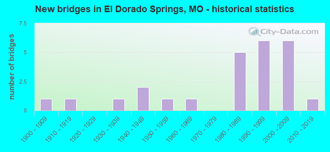
- New bridges - historical statistics
- 11900-1909
- 11910-1919
- 11930-1939
- 21940-1949
- 11950-1959
- 11960-1969
- 51980-1989
- 61990-1999
- 62000-2009
- 12010-2019

- Reconstructed bridges - Historical Statistics
- 11940-1949
- 01950-1959
- 01960-1969
- 21970-1979
- 11980-1989
- 11990-1999


- Bridge Condition - Deck
- 4.8%Excellent
- 9.5%Very good
- 76.2%Good
- 4.8%Fair
- 4.8%Serious

- Bridge Condition - Superstructure
- 4.8%Very good
- 42.9%Good
- 33.3%Satisfactory
- 4.8%Fair
- 9.5%Poor
- 4.8%Serious

- Bridge Condition - Substructure
- 4.8%Excellent
- 4.8%Very good
- 38.1%Good
- 28.6%Satisfactory
- 23.8%Fair

- Bridge Condition - Channel
- 12.0%Very good
- 12.0%Good
- 40.0%Satisfactory
- 28.0%Fair
- 8.0%Poor

- Bridge Condition - Culverts
- 25.0%Good
- 50.0%Satisfactory
- 25.0%Fair
Find on map >> Show street view
Structure Number: 12482, Location: S 22 T 36 N R 28 W (Lat: 37.877000, Lng: -94.002758), Route carried "on" structure: County highway 11, Year Built: 1910, Year Reconstructed: 1986, Status: Posted for load, Structure Length: 1.46m (4.79ft), Average Daily Traffic: 200 (year 2020), Truck Traffic: 10%, Average Future Daily Traffic: 250 (year 2040), Features Intersected: WALNUT CR, Facility Carried by Structure: COUNTY RD 150
Minimum Vertical Clearance: 30+ m (98+ ft), Kilometerpoint: 0.966, Lanes on structure: 2, Owner: County Highway Agency, Approaching Roadway Width: 6.4m (21.0ft), Material/Design: Steel, Design/Construction: Stringer/Multi-beam, Number Of Spans In Main Unit: 1, Length of Maximum Span: 14.0m (45.9ft), Curb-To-Curb Width: 7.4m (24.3ft), Out-to-Out Width: 7.7m (25.3ft)
Condition: Deck: Very good, Superstructure: Good, Substructure: Fair, Channel: Satisfactory, Operating Rating: 25.2 metric tons, Method Used To Determine Operating Rating: Allowable Stress (AS), Inventory Rating: 12.6 metric tons, Method Used To Determine Inventory Rating: Allowable Stress (AS), Structural Evaluation: Meets minimum limits, Deck Geometry: Somewhat better than minimum adequacy, Waterway Adequacy: Better than present minimum criteria, Approach Roadway Alignment: Equal to present desirable criteria, Designated Inspection Frequency: Every 24 months, Inspection Date: December 2020, Deck Structure Type: Concrete Cast-file-Place, Wearing Surface/Protective System: Wearing Surface: Bituminous
Find on map >> Show street view
Structure Number: 12961, Location: S 36 T 36 N R 28 W (Lat: 37.846522, Lng: -93.961806), Route carried "on" structure: County highway 25, Year Built: 1985, Status: Open, Structure Length: 0.85m (2.79ft), Average Daily Traffic: 50 (year 2020), Truck Traffic: 10%, Average Future Daily Traffic: 63 (year 2040), Features Intersected: TRIB OF LIT ALDER, Facility Carried by Structure: COUNTY RD 350
Minimum Vertical Clearance: 30+ m (98+ ft), Kilometerpoint: 1.287, Lanes on structure: 2, Owner: County Highway Agency, Approaching Roadway Width: 6.7m (22.0ft), Material/Design: Steel, Design/Construction: Stringer/Multi-beam, Number Of Spans In Main Unit: 1, Length of Maximum Span: 7.9m (25.9ft), Curb-To-Curb Width: 6.0m (19.7ft), Out-to-Out Width: 6.2m (20.3ft)
Condition: Deck: Good, Superstructure: Serious, Substructure: Good, Channel: Satisfactory, Operating Rating: 52.2 metric tons, Method Used To Determine Operating Rating: Allowable Stress (AS), Inventory Rating: 30.6 metric tons, Method Used To Determine Inventory Rating: Allowable Stress (AS), Structural Evaluation: High priority of corrective action, Deck Geometry: Meets minimum limits, Waterway Adequacy: Meets minimum limits, Approach Roadway Alignment: Equal to present desirable criteria, Length Of Structure Improvement: 0.15m (0.49ft), Designated Inspection Frequency: Every 24 months, Inspection Date: December 2021, Bridge Improvement Cost: $109,000, Roadway Improvement Cost: $11,000, Total Project Cost: $163,000 ( Estimate for 2022), Deck Structure Type: Concrete Cast-file-Place, Wearing Surface/Protective System: Wearing Surface: Monolithic Concrete
Find on map >> Show street view
Structure Number: 13058, Location: S 19 T 36 N R 28 W (Lat: 37.877236, Lng: -94.053006), Route carried "on" structure: County highway 28, Year Built: 1996, Status: Open, Structure Length: 1.10m (3.61ft), Average Daily Traffic: 50 (year 2020), Truck Traffic: 10%, Average Future Daily Traffic: 63 (year 2040), Design Load: HS 20, Features Intersected: MCCORD BR, Facility Carried by Structure: COUNTY RD 75
Minimum Vertical Clearance: 30+ m (98+ ft), Kilometerpoint: 0.322, Lanes on structure: 2, Owner: County Highway Agency, Approaching Roadway Width: 6.7m (22.0ft), Skew: 3 degrees, Material/Design: Concrete, Design/Construction: Culvert, Number Of Spans In Main Unit: 2, Length of Maximum Span: 4.9m (16.1ft), Curb-To-Curb Width: 7.9m (25.9ft), Out-to-Out Width: 8.5m (27.9ft)
Condition: Channel: Very good, Culverts: Good, Operating Rating: 54.0 metric tons, Method Used To Determine Operating Rating: Load Factor (LF), Inventory Rating: 32.4 metric tons, Method Used To Determine Inventory Rating: Load Factor (LF), Structural Evaluation: Better than present minimum criteria, Deck Geometry: Equal to present minimum criteria, Waterway Adequacy: Better than present minimum criteria, Approach Roadway Alignment: Equal to present desirable criteria, Designated Inspection Frequency: Every 24 months, Inspection Date: December 2020, Deck Structure Type: Concrete Cast-file-Place
Find on map >> Show street view
Structure Number: 13436, Location: S 16 T 36 N R 28 W (Lat: 37.884689, Lng: -94.018378), Route carried "on" structure: County highway 38, Year Built: 1993, Status: Open, Structure Length: 1.22m (4.00ft), Average Daily Traffic: 40 (year 2020), Truck Traffic: 10%, Average Future Daily Traffic: 50 (year 2040), Features Intersected: WALNUT CR, Facility Carried by Structure: COUNTY RD 100
Minimum Vertical Clearance: 30+ m (98+ ft), Kilometerpoint: 1.931, Lanes on structure: 2, Owner: County Highway Agency, Approaching Roadway Width: 5.5m (18.0ft), Material/Design: Steel, Design/Construction: Stringer/Multi-beam, Number Of Spans In Main Unit: 1, Length of Maximum Span: 11.6m (38.1ft), Curb-To-Curb Width: 6.2m (20.3ft), Out-to-Out Width: 6.2m (20.3ft)
Condition: Deck: Good, Superstructure: Satisfactory, Substructure: Good, Channel: Good, Operating Rating: 54.0 metric tons, Method Used To Determine Operating Rating: Load Factor (LF), Inventory Rating: 32.4 metric tons, Method Used To Determine Inventory Rating: Load Factor (LF), Structural Evaluation: Equal to present minimum criteria, Deck Geometry: Somewhat better than minimum adequacy, Waterway Adequacy: Equal to present minimum criteria, Approach Roadway Alignment: Equal to present desirable criteria, Designated Inspection Frequency: Every 24 months, Inspection Date: December 2020, Deck Structure Type: Concrete Cast-file-Place, Wearing Surface/Protective System: Wearing Surface: Bituminous
Find on map >> Show street view
Structure Number: 15108, Location: S 9 T 35 N R 28 W (Lat: 37.819261, Lng: -94.017767), Route carried "on" structure: County highway 85, Year Built: 1950, Year Reconstructed: 1981, Status: Posted for load, Structure Length: 0.67m (2.20ft), Average Daily Traffic: 100 (year 2020), Truck Traffic: 10%, Average Future Daily Traffic: 125 (year 2040), Features Intersected: ALDER BR, Facility Carried by Structure: COUNTY RD 550
Minimum Vertical Clearance: 30+ m (98+ ft), Kilometerpoint: 2.253, Lanes on structure: 1, Owner: County Highway Agency, Approaching Roadway Width: 6.4m (21.0ft), Material/Design: Steel, Design/Construction: Stringer/Multi-beam, Number Of Spans In Main Unit: 1, Length of Maximum Span: 6.4m (21.0ft), Curb-To-Curb Width: 4.0m (13.1ft), Out-to-Out Width: 4.3m (14.1ft)
Condition: Deck: Good, Superstructure: Satisfactory, Substructure: Satisfactory, Channel: Fair, Operating Rating: 13.5 metric tons, Method Used To Determine Operating Rating: Allowable Stress (AS), Inventory Rating: 7.2 metric tons, Method Used To Determine Inventory Rating: Allowable Stress (AS), Structural Evaluation: High priority of replacement, Deck Geometry: Somewhat better than minimum adequacy, Waterway Adequacy: Equal to present minimum criteria, Approach Roadway Alignment: Equal to present minimum criteria, Bridge Posting: Required (Relationship of Operating Rating to Maximum Legal Load: > 39.9% below), Length Of Structure Improvement: 0.13m (0.43ft), Designated Inspection Frequency: Every 24 months, Inspection Date: December 2020, Bridge Improvement Cost: $95,000, Roadway Improvement Cost: $10,000, Total Project Cost: $143,000 ( Estimate for 2022), Deck Structure Type: Concrete Cast-file-Place, Wearing Surface/Protective System: Wearing Surface: Monolithic Concrete
Find on map >> Show street view
Structure Number: 17736, Location: S 13 T 35 N R 28 W (Lat: 37.800317, Lng: -93.979108), Route carried "on" structure: County highway 161, Year Built: 1987, Status: Open, Structure Length: 2.71m (8.89ft), Average Daily Traffic: 35 (year 2020), Truck Traffic: 10%, Average Future Daily Traffic: 44 (year 2040), Design Load: H 15, Features Intersected: ALDER CR, Facility Carried by Structure: COUNTY RD 501
Minimum Vertical Clearance: 30+ m (98+ ft), Kilometerpoint: 2.092, Lanes on structure: 2, Owner: County Highway Agency, Approaching Roadway Width: 7.9m (25.9ft), Material/Design: Prestressed concrete continuous, Design/Construction: Tee Beam, Number Of Spans In Main Unit: 3, Length of Maximum Span: 9.1m (29.9ft), Curb-To-Curb Width: 7.3m (24.0ft), Out-to-Out Width: 8.2m (26.9ft)
Condition: Deck: Good, Superstructure: Good, Substructure: Good, Channel: Satisfactory, Operating Rating: 49.5 metric tons, Method Used To Determine Operating Rating: Allowable Stress (AS), Inventory Rating: 32.4 metric tons, Method Used To Determine Inventory Rating: Allowable Stress (AS), Structural Evaluation: Better than present minimum criteria, Deck Geometry: Equal to present minimum criteria, Waterway Adequacy: Better than present minimum criteria, Approach Roadway Alignment: Equal to present desirable criteria, Designated Inspection Frequency: Every 24 months, Inspection Date: December 2020, Deck Structure Type: Concrete Cast-file-Place, Wearing Surface/Protective System: Wearing Surface: Monolithic Concrete
Find on map >> Show street view
Structure Number: 18097, Location: S 6 T 35 N R 27 W (Lat: 37.831933, Lng: -93.950458), Route carried "on" structure: County highway 173, Year Built: 1940, Year Reconstructed: 1983, Status: Posted for load, Structure Length: 1.04m (3.41ft), Average Daily Traffic: 25 (year 2020), Truck Traffic: 10%, Average Future Daily Traffic: 31 (year 2040), Design Load: H 10, Features Intersected: LIT ADLER CR, Facility Carried by Structure: COUNTY RD 651
Minimum Vertical Clearance: 30+ m (98+ ft), Kilometerpoint: 0.805, Lanes on structure: 1, Owner: County Highway Agency, Approaching Roadway Width: 4.6m (15.1ft), Material/Design: Steel, Design/Construction: Stringer/Multi-beam, Number Of Spans In Main Unit: 1, Length of Maximum Span: 10.1m (33.1ft), Curb-To-Curb Width: 5.0m (16.4ft), Out-to-Out Width: 5.0m (16.4ft)
Condition: Deck: Good, Superstructure: Satisfactory, Substructure: Fair, Channel: Fair, Operating Rating: 22.5 metric tons, Method Used To Determine Operating Rating: Allowable Stress (AS), Inventory Rating: 12.6 metric tons, Method Used To Determine Inventory Rating: Allowable Stress (AS), Structural Evaluation: Meets minimum limits, Deck Geometry: High priority of corrective action, Waterway Adequacy: High priority of corrective action, Approach Roadway Alignment: Equal to present minimum criteria, Bridge Posting: Required (Relationship of Operating Rating to Maximum Legal Load: 0.1 - 9.9% below), Length Of Structure Improvement: 0.17m (0.56ft), Designated Inspection Frequency: Every 24 months, Inspection Date: December 2020, Bridge Improvement Cost: $124,000, Roadway Improvement Cost: $12,000, Total Project Cost: $186,000 ( Estimate for 2022), Deck Structure Type: Concrete Cast-file-Place, Wearing Surface/Protective System: Wearing Surface: Monolithic Concrete
Find on map >> Show street view
Structure Number: 20382, Location: S 29 T 37 N R 28 W (Lat: 37.948422, Lng: -94.036819), Route carried "on" structure: County highway 257, Year Built: 1996, Status: Open, Structure Length: 3.81m (12.50ft), Average Daily Traffic: 10 (year 2021), Truck Traffic: 10%, Average Future Daily Traffic: 12 (year 2041), Design Load: HS 20, Features Intersected: CLEAR CR, Facility Carried by Structure: COUNTY RD SW 1371
Minimum Vertical Clearance: 30+ m (98+ ft), Kilometerpoint: 3.219, Lanes on structure: 1, Owner: County Highway Agency, Approaching Roadway Width: 4.6m (15.1ft), Material/Design: Steel, Design/Construction: Stringer/Multi-beam, Number Of Spans In Main Unit: 1, Number Of Approach Spans: 1, Length of Maximum Span: 24.4m (80.1ft), Curb-To-Curb Width: 5.0m (16.4ft), Out-to-Out Width: 5.0m (16.4ft)
Condition: Deck: Good, Superstructure: Good, Substructure: Satisfactory, Channel: Fair, Operating Rating: 51.3 metric tons, Method Used To Determine Operating Rating: Allowable Stress (AS), Inventory Rating: 30.6 metric tons, Method Used To Determine Inventory Rating: Allowable Stress (AS), Structural Evaluation: Equal to present minimum criteria, Deck Geometry: High priority of corrective action, Waterway Adequacy: Somewhat better than minimum adequacy, Approach Roadway Alignment: Meets minimum limits, Designated Inspection Frequency: Every 24 months, Inspection Date: December 2021, Deck Structure Type: Concrete Cast-file-Place, Wearing Surface/Protective System: Wearing Surface: Monolithic Concrete
Find on map >> Show street view
Structure Number: 20752, Location: S 35 T 36 N R 29 W (Lat: 37.854172, Lng: -94.091497), Route carried "on" structure: County highway 273, Year Built: 1999, Status: Open, Structure Length: 1.86m (6.10ft), Average Daily Traffic: 25 (year 2022), Truck Traffic: 10%, Average Future Daily Traffic: 33 (year 2042), Design Load: HS 20, Features Intersected: FLY CR, Facility Carried by Structure: COUNTY RD 2975
Minimum Vertical Clearance: 30+ m (98+ ft), Kilometerpoint: 0.966, Lanes on structure: 2, Owner: County Highway Agency, Approaching Roadway Width: 5.5m (18.0ft), Material/Design: Steel, Design/Construction: Stringer/Multi-beam, Number Of Spans In Main Unit: 1, Length of Maximum Span: 17.7m (58.1ft), Curb-To-Curb Width: 6.1m (20.0ft), Out-to-Out Width: 6.2m (20.3ft)
Condition: Deck: Good, Superstructure: Good, Substructure: Good, Channel: Very good, Operating Rating: 23.4 metric tons, Method Used To Determine Operating Rating: Load Factor (LF), Inventory Rating: 14.4 metric tons, Method Used To Determine Inventory Rating: Load Factor (LF), Structural Evaluation: Meets minimum limits, Deck Geometry: Somewhat better than minimum adequacy, Waterway Adequacy: Equal to present minimum criteria, Approach Roadway Alignment: Equal to present desirable criteria, Designated Inspection Frequency: Every 24 months, Inspection Date: January 2022, Deck Structure Type: Concrete Cast-file-Place, Wearing Surface/Protective System: Wearing Surface: Monolithic Concrete
Find on map >> Show street view
Structure Number: 20834, Location: S 1 T 36 N R 29 W (Lat: 37.920767, Lng: -94.073906), Route carried "on" structure: County highway 277, Year Built: 1989, Status: Open, Structure Length: 1.13m (3.71ft), Average Daily Traffic: 30 (year 2022), Truck Traffic: 10%, Average Future Daily Traffic: 39 (year 2042), Features Intersected: BEECHAM BR, Facility Carried by Structure: COUNTY RD 3050
Minimum Vertical Clearance: 30+ m (98+ ft), Kilometerpoint: 0.483, Lanes on structure: 2, Owner: County Highway Agency, Approaching Roadway Width: 7.3m (24.0ft), Skew: 3 degrees, Material/Design: Concrete, Design/Construction: Culvert, Number Of Spans In Main Unit: 2, Length of Maximum Span: 4.6m (15.1ft), Curb-To-Curb Width: 9.4m (30.8ft), Out-to-Out Width: 10.0m (32.8ft)
Condition: Channel: Fair, Culverts: Satisfactory, Operating Rating: 49.5 metric tons, Method Used To Determine Operating Rating: Allowable Stress (AS), Inventory Rating: 16.2 metric tons, Method Used To Determine Inventory Rating: Allowable Stress (AS), Structural Evaluation: Somewhat better than minimum adequacy, Deck Geometry: Better than present minimum criteria, Waterway Adequacy: Equal to present minimum criteria, Approach Roadway Alignment: Equal to present desirable criteria, Designated Inspection Frequency: Every 24 months, Inspection Date: January 2022
Find on map >> Show street view
Structure Number: 22027, Location: S 26 T 36 N R 29 W (Lat: 37.865475, Lng: -94.095894), Route carried "on" structure: County highway 336, Year Built: 1900, Status: Posted for load, Structure Length: 3.02m (9.91ft), Average Daily Traffic: 4 (year 2022), Truck Traffic: 10%, Average Future Daily Traffic: 5 (year 2042), Features Intersected: CLEAR CR, Facility Carried by Structure: LOGAN RD
Minimum Vertical Clearance: 4.27m (14.01ft), Kilometerpoint: 3.219, Lanes on structure: 1, Owner: County Highway Agency, Approaching Roadway Width: 3.7m (12.1ft), Material/Design: Steel, Design/Construction: Truss - Thru, Number Of Spans In Main Unit: 1, Length of Maximum Span: 30.2m (99.1ft), Curb-To-Curb Width: 3.4m (11.2ft), Out-to-Out Width: 3.7m (12.1ft)
Condition: Deck: Good, Superstructure: Poor, Substructure: Satisfactory, Channel: Satisfactory, Operating Rating: 14.4 metric tons, Method Used To Determine Operating Rating: Allowable Stress (AS), Inventory Rating: 5.4 metric tons, Method Used To Determine Inventory Rating: Allowable Stress (AS), Structural Evaluation: High priority of replacement, Deck Geometry: High priority of corrective action, Waterway Adequacy: Equal to present minimum criteria, Approach Roadway Alignment: Meets minimum limits, Bridge Posting: Required (Relationship of Operating Rating to Maximum Legal Load: > 39.9% below), Length Of Structure Improvement: 0.39m (1.28ft), Designated Inspection Frequency: Every 24 months, Critical Feature Inspection Frequency: Every 24 months, Inspection Date: January 2022, Critical Feature Inspection Date: May 2020, Bridge Improvement Cost: $284,000, Roadway Improvement Cost: $28,000, Total Project Cost: $426,000 ( Estimate for 2022), Deck Structure Type: Wood or Timber
Find on map >> Show street view
Structure Number: 28285, Location: S 2 T 36 N R 28 W (Lat: 37.917289, Lng: -93.981142), Route carried "on" structure: County highway 365, Year Built: 1998, Status: Open, Structure Length: 0.67m (2.20ft), Average Daily Traffic: 40 (year 2021), Truck Traffic: 10%, Average Future Daily Traffic: 48 (year 2041), Design Load: HS 20, Features Intersected: TRIB OF LIT CLEAR, Facility Carried by Structure: COUNTY RD SW 1051
Minimum Vertical Clearance: 30+ m (98+ ft), Kilometerpoint: 0.966, Lanes on structure: 2, Owner: County Highway Agency, Approaching Roadway Width: 5.5m (18.0ft), Material/Design: Concrete continuous, Design/Construction: Slab, Number Of Spans In Main Unit: 2, Length of Maximum Span: 3.0m (9.8ft), Curb-To-Curb Width: 5.6m (18.4ft), Out-to-Out Width: 6.1m (20.0ft)
Condition: Deck: Good, Superstructure: Good, Substructure: Good, Channel: Good, Operating Rating: 63.0 metric tons, Method Used To Determine Operating Rating: Load Factor (LF), Inventory Rating: 37.8 metric tons, Method Used To Determine Inventory Rating: Load Factor (LF), Structural Evaluation: Better than present minimum criteria, Deck Geometry: Meets minimum limits, Waterway Adequacy: Better than present minimum criteria, Approach Roadway Alignment: Equal to present desirable criteria, Designated Inspection Frequency: Every 24 months, Inspection Date: December 2021, Deck Structure Type: Concrete Cast-file-Place
Find on map >> Show street view
Structure Number: 28731, Location: S 8 T 36 N R 28 W (Lat: 37.904025, Lng: -94.042556), Route carried "on" structure: County highway 362, Year Built: 2001, Status: Open, Structure Length: 1.49m (4.89ft), Average Daily Traffic: 50 (year 2021), Truck Traffic: 10%, Average Future Daily Traffic: 60 (year 2041), Features Intersected: TRIB OF WALNUT CR, Facility Carried by Structure: COUNTY RD SW 1371
Minimum Vertical Clearance: 30+ m (98+ ft), Kilometerpoint: 3.219, Lanes on structure: 2, Owner: County Highway Agency, Approaching Roadway Width: 4.9m (16.1ft), Material/Design: Steel, Design/Construction: Stringer/Multi-beam, Number Of Spans In Main Unit: 1, Length of Maximum Span: 14.0m (45.9ft), Curb-To-Curb Width: 6.0m (19.7ft), Out-to-Out Width: 6.2m (20.3ft)
Condition: Deck: Good, Superstructure: Satisfactory, Substructure: Fair, Channel: Satisfactory, Operating Rating: 49.5 metric tons, Method Used To Determine Operating Rating: Load Factor (LF), Inventory Rating: 29.7 metric tons, Method Used To Determine Inventory Rating: Load Factor (LF), Structural Evaluation: Somewhat better than minimum adequacy, Deck Geometry: Meets minimum limits, Waterway Adequacy: Somewhat better than minimum adequacy, Approach Roadway Alignment: Equal to present minimum criteria, Designated Inspection Frequency: Every 24 months, Inspection Date: December 2021, Deck Structure Type: Concrete Cast-file-Place, Wearing Surface/Protective System: Wearing Surface: Monolithic Concrete
Find on map >> Show street view
Structure Number: 29174, Location: S 12 T 35 N R 29 W (Lat: 37.821067, Lng: -94.076319), Route carried "on" structure: County highway 749, Year Built: 2001, Status: Open, Structure Length: 0.73m (2.40ft), Average Daily Traffic: 5 (year 2022), Truck Traffic: 10%, Average Future Daily Traffic: 7 (year 2042), Features Intersected: TRIB OF FLY CR, Facility Carried by Structure: COUNTY RD OVERLAND
Minimum Vertical Clearance: 30+ m (98+ ft), Kilometerpoint: 0.000, Lanes on structure: 2, Owner: County Highway Agency, Approaching Roadway Width: 3.7m (12.1ft), Material/Design: Steel, Design/Construction: Stringer/Multi-beam, Number Of Spans In Main Unit: 1, Length of Maximum Span: 6.4m (21.0ft), Curb-To-Curb Width: 6.1m (20.0ft), Out-to-Out Width: 6.2m (20.3ft)
Condition: Deck: Good, Superstructure: Good, Substructure: Satisfactory, Channel: Satisfactory, Operating Rating: 63.0 metric tons, Method Used To Determine Operating Rating: Load Factor (LF), Inventory Rating: 37.8 metric tons, Method Used To Determine Inventory Rating: Load Factor (LF), Structural Evaluation: Equal to present minimum criteria, Deck Geometry: Somewhat better than minimum adequacy, Waterway Adequacy: Better than present minimum criteria, Approach Roadway Alignment: Equal to present desirable criteria, Designated Inspection Frequency: Every 24 months, Inspection Date: January 2022, Deck Structure Type: Concrete Cast-file-Place, Wearing Surface/Protective System: Wearing Surface: Monolithic Concrete
Find on map >> Show street view
Structure Number: 29623, Location: S 35 T 36 N R 28 W (Lat: 37.847019, Lng: -93.976419), Route carried "on" structure: County highway 350, Year Built: 1940, Year Reconstructed: 2002, Status: Posted for load, Structure Length: 0.91m (2.99ft), Average Daily Traffic: 75 (year 2020), Truck Traffic: 10%, Average Future Daily Traffic: 94 (year 2040), Features Intersected: LIT ALDER CR
Minimum Vertical Clearance: 30+ m (98+ ft), Kilometerpoint: 0.000, Lanes on structure: 2, Owner: County Highway Agency, Approaching Roadway Width: 4.9m (16.1ft), Material/Design: Steel, Design/Construction: Stringer/Multi-beam, Number Of Spans In Main Unit: 1, Length of Maximum Span: 9.1m (29.9ft), Curb-To-Curb Width: 5.5m (18.0ft), Out-to-Out Width: 5.5m (18.0ft)
Condition: Deck: Fair, Superstructure: Satisfactory, Substructure: Good, Channel: Satisfactory, Operating Rating: 22.5 metric tons, Method Used To Determine Operating Rating: Load Factor (LF), Inventory Rating: 13.5 metric tons, Method Used To Determine Inventory Rating: Load Factor (LF), Structural Evaluation: Meets minimum limits, Deck Geometry: Meets minimum limits, Waterway Adequacy: Meets minimum limits, Approach Roadway Alignment: Equal to present desirable criteria, Bridge Posting: Required (Relationship of Operating Rating to Maximum Legal Load: 10.0 - 19.9% below), Designated Inspection Frequency: Every 24 months, Inspection Date: December 2020, Deck Structure Type: Concrete Cast-file-Place, Wearing Surface/Protective System: Wearing Surface: Bituminous
Find on map >> Show street view
Structure Number: 30301, Location: S 2 T 36 N R 28 W (Lat: 37.921964, Lng: -93.980858), Route carried "on" structure: County highway 1051, Year Built: 2002, Status: Open, Structure Length: 0.82m (2.69ft), Average Daily Traffic: 40 (year 2021), Truck Traffic: 10%, Average Future Daily Traffic: 48 (year 2041), Features Intersected: TRIB OF LIT CLEAR
Minimum Vertical Clearance: 30+ m (98+ ft), Kilometerpoint: 0.000, Lanes on structure: 2, Owner: County Highway Agency, Approaching Roadway Width: 5.5m (18.0ft), Material/Design: Steel, Design/Construction: Stringer/Multi-beam, Number Of Spans In Main Unit: 1, Length of Maximum Span: 7.9m (25.9ft), Curb-To-Curb Width: 5.9m (19.4ft), Out-to-Out Width: 6.1m (20.0ft)
Condition: Deck: Good, Superstructure: Satisfactory, Substructure: Fair, Channel: Poor, Operating Rating: 57.6 metric tons, Method Used To Determine Operating Rating: Load Factor (LF), Inventory Rating: 35.1 metric tons, Method Used To Determine Inventory Rating: Load Factor (LF), Structural Evaluation: Somewhat better than minimum adequacy, Deck Geometry: Meets minimum limits, Waterway Adequacy: Better than present minimum criteria, Approach Roadway Alignment: Equal to present desirable criteria, Designated Inspection Frequency: Every 24 months, Inspection Date: December 2021, Deck Structure Type: Concrete Cast-file-Place, Wearing Surface/Protective System: Wearing Surface: Monolithic Concrete
Find on map >> Show street view
Structure Number: 30356, Location: S 13 T 36 N R 29 W (Lat: 37.897569, Lng: -94.075394), Route carried "on" structure: County highway 278, Year Built: 2002, Status: Open, Structure Length: 0.94m (3.08ft), Average Daily Traffic: 25 (year 2022), Truck Traffic: 5%, Average Future Daily Traffic: 33 (year 2042), Features Intersected: TRIB OF CLEAR CR, Facility Carried by Structure: COUNTY RD 3050
Minimum Vertical Clearance: 30+ m (98+ ft), Kilometerpoint: 0.000, Lanes on structure: 2, Owner: County Highway Agency, Approaching Roadway Width: 5.5m (18.0ft), Material/Design: Steel, Design/Construction: Stringer/Multi-beam, Number Of Spans In Main Unit: 1, Length of Maximum Span: 9.1m (29.9ft), Curb-To-Curb Width: 6.1m (20.0ft), Out-to-Out Width: 6.2m (20.3ft)
Condition: Deck: Good, Superstructure: Fair, Substructure: Good, Channel: Satisfactory, Operating Rating: 34.2 metric tons, Method Used To Determine Operating Rating: Load Factor (LF), Inventory Rating: 20.7 metric tons, Method Used To Determine Inventory Rating: Load Factor (LF), Structural Evaluation: Somewhat better than minimum adequacy, Deck Geometry: Somewhat better than minimum adequacy, Waterway Adequacy: Better than present minimum criteria, Approach Roadway Alignment: Equal to present desirable criteria, Designated Inspection Frequency: Every 24 months, Inspection Date: January 2022, Deck Structure Type: Concrete Cast-file-Place, Wearing Surface/Protective System: Wearing Surface: Monolithic Concrete
Find on map >> Show street view
Structure Number: 30795, Location: S 23 T 35 N R 28 W (Lat: 37.796067, Lng: -93.997819), Route carried "on" structure: County highway 401, Year Built: 2004, Status: Open, Structure Length: 1.83m (6.00ft), Average Daily Traffic: 30 (year 2020), Truck Traffic: 10%, Average Future Daily Traffic: 38 (year 2040), Design Load: HS 20, Features Intersected: ALDER CR
Minimum Vertical Clearance: 30+ m (98+ ft), Kilometerpoint: 3.058, Lanes on structure: 2, Owner: County Highway Agency, Approaching Roadway Width: 7.9m (25.9ft), Skew: 1 degrees, Material/Design: Prestressed concrete, Design/Construction: Stringer/Multi-beam, Number Of Spans In Main Unit: 1, Length of Maximum Span: 16.8m (55.1ft), Curb-To-Curb Width: 7.9m (25.9ft), Out-to-Out Width: 8.8m (28.9ft)
Condition: Deck: Good, Superstructure: Very good, Substructure: Very good, Channel: Good, Operating Rating: 68.4 metric tons, Method Used To Determine Operating Rating: Load Factor (LF), Inventory Rating: 41.4 metric tons, Method Used To Determine Inventory Rating: Load Factor (LF), Structural Evaluation: Equal to present desirable criteria, Deck Geometry: Equal to present minimum criteria, Waterway Adequacy: Better than present minimum criteria, Approach Roadway Alignment: Equal to present desirable criteria, Designated Inspection Frequency: Every 24 months, Inspection Date: December 2020, Deck Structure Type: Concrete Cast-file-Place, Wearing Surface/Protective System: Wearing Surface: Monolithic Concrete
Find on map >> Show street view
Structure Number: 32439, Location: S 36 T 36 N R 29 W (Lat: 37.850214, Lng: -94.073711), Route carried "on" structure: County highway 346, Year Built: 2006, Status: Open, Structure Length: 1.39m (4.56ft), Average Daily Traffic: 15 (year 2022), Truck Traffic: 10%, Average Future Daily Traffic: 20 (year 2042), Design Load: HS 20, Features Intersected: TRIB OF FLY CR, Facility Carried by Structure: MISSION RD
Minimum Vertical Clearance: 30+ m (98+ ft), Kilometerpoint: 1.770, Lanes on structure: 2, Owner: County Highway Agency, Approaching Roadway Width: 6.7m (22.0ft), Material/Design: Steel, Design/Construction: Stringer/Multi-beam, Number Of Spans In Main Unit: 1, Length of Maximum Span: 13.0m (42.7ft), Curb or Sidewalk Widths: Left: 0.1m (0.3ft), Right: 0.1m (0.3ft), Curb-To-Curb Width: 6.6m (21.7ft), Out-to-Out Width: 6.7m (22.0ft)
Condition: Deck: Excellent, Superstructure: Good, Substructure: Satisfactory, Channel: Very good, Operating Rating: 61.2 metric tons, Method Used To Determine Operating Rating: Load Factor (LF), Inventory Rating: 36.0 metric tons, Method Used To Determine Inventory Rating: Load Factor (LF), Structural Evaluation: Equal to present minimum criteria, Deck Geometry: Somewhat better than minimum adequacy, Waterway Adequacy: Better than present minimum criteria, Approach Roadway Alignment: Equal to present desirable criteria, Designated Inspection Frequency: Every 24 months, Inspection Date: January 2022, Deck Structure Type: Concrete Cast-file-Place, Wearing Surface/Protective System: Wearing Surface: Monolithic Concrete
Find on map >> Show street view
Structure Number: 33211, Location: S 16 T 36 N R 28 W (Lat: 37.889000, Lng: -94.021408), Route carried "on" structure: State highway 82, Year Built: 2010, Status: Open, Structure Length: 2.74m (8.99ft), Average Daily Traffic: 1,755 (year 2021), Truck Traffic: 9%, Average Future Daily Traffic: 2,633 (year 2041), Design Load: HS 20, Features Intersected: WALNUT CR
Minimum Vertical Clearance: 30+ m (98+ ft), Kilometerpoint: 2.863, Lanes on structure: 2, Base Highway Network: Yes, Owner: State Highway Agency, Approaching Roadway Width: 8.5m (27.9ft), Material/Design: Prestressed concrete, Design/Construction: Box Beam or Girders - Single/Spread, Number Of Spans In Main Unit: 1, Length of Maximum Span: 27.4m (89.9ft), Curb-To-Curb Width: 8.5m (27.9ft), Out-to-Out Width: 9.1m (29.9ft)
Condition: Deck: Good, Superstructure: Good, Substructure: Good, Channel: Satisfactory, Operating Rating: 96.3 metric tons, Method Used To Determine Operating Rating: Load Factor (LF), Inventory Rating: 49.5 metric tons, Method Used To Determine Inventory Rating: Load Factor (LF), Structural Evaluation: Better than present minimum criteria, Deck Geometry: Somewhat better than minimum adequacy, Waterway Adequacy: Superior to present desirable criteria, Approach Roadway Alignment: Meets minimum limits, Designated Inspection Frequency: Every 24 months, Inspection Date: June 2021, Deck Structure Type: Concrete Cast-file-Place, Wearing Surface/Protective System: Wearing Surface: Monolithic Concrete, Deck Protection: Epoxy Coated Reinforcing
Find on map >> Show street view
Structure Number: 3956, Location: S 9 T 35 N R 28 W (Lat: 37.815869, Lng: -94.015194), Route carried "on" structure: State highway 32, Year Built: 1989, Status: Open, Structure Length: 0.76m (2.49ft), Average Daily Traffic: 1,834 (year 2021), Truck Traffic: 15%, Average Future Daily Traffic: 2,751 (year 2041), Design Load: HS 20, Features Intersected: LIT ALDER CR
Minimum Vertical Clearance: 30+ m (98+ ft), Kilometerpoint: 5.203, Lanes on structure: 2, Base Highway Network: Yes, Owner: State Highway Agency, Approaching Roadway Width: 12.2m (40.0ft), Skew: 2 degrees, Material/Design: Concrete continuous, Design/Construction: Culvert, Number Of Spans In Main Unit: 2, Length of Maximum Span: 3.4m (11.2ft)
Condition: Channel: Fair, Culverts: Satisfactory, Inventory Rating: 79.2 metric tons, Method Used To Determine Inventory Rating: Load Factor (LF), Structural Evaluation: Equal to present minimum criteria, Waterway Adequacy: Equal to present desirable criteria, Approach Roadway Alignment: Equal to present desirable criteria, Designated Inspection Frequency: Every 24 months, Inspection Date: January 2022
Find on map >> Show street view
Structure Number: 3957, Location: S 15 T 35 N R 28 W (Lat: 37.800000, Lng: -94.016944), Route carried "on" structure: State highway 32, Year Built: 1989, Status: Open, Structure Length: 5.73m (18.80ft), Average Daily Traffic: 1,834 (year 2021), Truck Traffic: 15%, Average Future Daily Traffic: 2,751 (year 2041), Design Load: HS 20, Features Intersected: BIG ALDER CR
Minimum Vertical Clearance: 30+ m (98+ ft), Kilometerpoint: 6.970, Lanes on structure: 2, Base Highway Network: Yes, Owner: State Highway Agency, Approaching Roadway Width: 6.4m (21.0ft), Skew: 4 degrees, Material/Design: Prestressed concrete continuous, Design/Construction: Stringer/Multi-beam, Number Of Spans In Main Unit: 3, Length of Maximum Span: 19.2m (63.0ft), Curb or Sidewalk Widths: Left: 0.2m (0.7ft), Right: 0.2m (0.7ft), Curb-To-Curb Width: 11.8m (38.7ft), Out-to-Out Width: 12.6m (41.3ft)
Condition: Deck: Good, Superstructure: Satisfactory, Substructure: Fair, Channel: Satisfactory, Operating Rating: 70.2 metric tons, Method Used To Determine Operating Rating: Allowable Stress (AS), Inventory Rating: 36.9 metric tons, Method Used To Determine Inventory Rating: Allowable Stress (AS), Structural Evaluation: Somewhat better than minimum adequacy, Deck Geometry: Equal to present minimum criteria, Waterway Adequacy: Equal to present desirable criteria, Approach Roadway Alignment: Equal to present desirable criteria, Designated Inspection Frequency: Every 24 months, Inspection Date: June 2021, Deck Structure Type: Concrete Cast-file-Place, Wearing Surface/Protective System: Wearing Surface: Monolithic Concrete, Deck Protection: Epoxy Coated Reinforcing
Find on map >> Show street view
Structure Number: 4356, Location: S 25 T 36 N R 29 W (Lat: 37.864528, Lng: -94.079461), Route carried "on" structure: US 54, Year Built: 1997, Status: Open, Structure Length: 4.79m (15.72ft), Average Daily Traffic: 5,514 (year 2021), Truck Traffic: 14%, Average Future Daily Traffic: 9,650 (year 2041), Design Load: HS 25 or greater, Features Intersected: FLY CR
Minimum Vertical Clearance: 30+ m (98+ ft), Kilometerpoint: 49.122, Lanes on structure: 2, Base Highway Network: Yes, Owner: State Highway Agency, Approaching Roadway Width: 13.4m (44.0ft), Material/Design: Prestressed concrete continuous, Design/Construction: Stringer/Multi-beam, Number Of Spans In Main Unit: 3, Length of Maximum Span: 16.0m (52.5ft), Curb or Sidewalk Widths: Left: 0.2m (0.7ft), Right: 0.2m (0.7ft), Curb-To-Curb Width: 13.0m (42.7ft), Out-to-Out Width: 13.9m (45.6ft)
Condition: Deck: Very good, Superstructure: Good, Substructure: Excellent, Channel: Fair, Operating Rating: 76.5 metric tons, Method Used To Determine Operating Rating: Load Factor (LF), Inventory Rating: 45.9 metric tons, Method Used To Determine Inventory Rating: Load Factor (LF), Structural Evaluation: Better than present minimum criteria, Deck Geometry: Somewhat better than minimum adequacy, Waterway Adequacy: Superior to present desirable criteria, Approach Roadway Alignment: Equal to present desirable criteria, Designated Inspection Frequency: Every 24 months, Inspection Date: June 2021, Deck Structure Type: Concrete Cast-file-Place, Wearing Surface/Protective System: Wearing Surface: Monolithic Concrete, Deck Protection: Epoxy Coated Reinforcing
Find on map >> Show street view
Structure Number: 4462, Location: S 29 T 36 N R 28 W (Lat: 37.863806, Lng: -94.045231), Route carried "on" structure: US 54, Year Built: 1932, Year Reconstructed: 1940, Status: Open, Structure Length: 0.76m (2.49ft), Average Daily Traffic: 5,514 (year 2021), Truck Traffic: 14%, Average Future Daily Traffic: 9,650 (year 2041), Design Load: H 15, Features Intersected: MC CORD CR
Minimum Vertical Clearance: 30+ m (98+ ft), Kilometerpoint: 52.161, Lanes on structure: 2, Base Highway Network: Yes, Owner: State Highway Agency, Approaching Roadway Width: 11.0m (36.1ft), Material/Design: Concrete continuous, Design/Construction: Culvert, Number Of Spans In Main Unit: 2, Length of Maximum Span: 3.7m (12.1ft)
Condition: Channel: Fair, Culverts: Fair, Inventory Rating: 85.5 metric tons, Method Used To Determine Inventory Rating: Load Factor (LF), Structural Evaluation: Somewhat better than minimum adequacy, Waterway Adequacy: Equal to present desirable criteria, Approach Roadway Alignment: Equal to present desirable criteria, Designated Inspection Frequency: Every 24 months, Inspection Date: January 2022
Find on map >> Show street view
Structure Number: 8234, Location: S 18 T 36 N R 28 W (Lat: 37.897678, Lng: -94.054900), Route carried "on" structure: State highway EE, Year Built: 1962, Status: Posted for load, Structure Length: 7.32m (24.02ft), Average Daily Traffic: 1,414 (year 2021), Truck Traffic: 11%, Average Future Daily Traffic: 2,050 (year 2041), Design Load: H 15, Features Intersected: CLEAR CR
Minimum Vertical Clearance: 30+ m (98+ ft), Kilometerpoint: 17.943, Lanes on structure: 2, Owner: State Highway Agency, Approaching Roadway Width: 6.1m (20.0ft), Material/Design: Steel continuous, Design/Construction: Stringer/Multi-beam, Number Of Spans In Main Unit: 3, Length of Maximum Span: 28.3m (92.8ft), Curb-To-Curb Width: 6.7m (22.0ft), Out-to-Out Width: 7.4m (24.3ft)
Condition: Deck: Serious, Superstructure: Poor, Substructure: Satisfactory, Channel: Poor, Operating Rating: 24.3 metric tons, Method Used To Determine Operating Rating: Load Factor (LF), Inventory Rating: 14.4 metric tons, Method Used To Determine Inventory Rating: Load Factor (LF), Structural Evaluation: Meets minimum limits, Deck Geometry: High priority of corrective action, Waterway Adequacy: Equal to present minimum criteria, Approach Roadway Alignment: Equal to present desirable criteria, Bridge Posting: Required (Relationship of Operating Rating to Maximum Legal Load: 0.1 - 9.9% below), Length Of Structure Improvement: 0.83m (2.72ft), Designated Inspection Frequency: Every 12 months, Inspection Date: June 2021, Bridge Improvement Cost: $946,000, Roadway Improvement Cost: $95,000, Total Project Cost: $1,420,000 ( Estimate for 2022), Deck Structure Type: Concrete Cast-file-Place, Wearing Surface/Protective System: Wearing Surface: Bituminous