Bridge Statistics for Eldred, Pennsylvania (PA)
Condition, Traffic, Stress, Structural Evaluation, Project Costs
- National Bridge Inventory (NBI) Statistics
- 15Number of bridges
- 144ft / 44.1mTotal length
- $1,572,000Total costs
- 20,868Total average daily traffic
- 1,936Total average daily truck traffic
- National Bridge Inventory (NBI) Registered Bridges for Eldred
- No street view available for this location
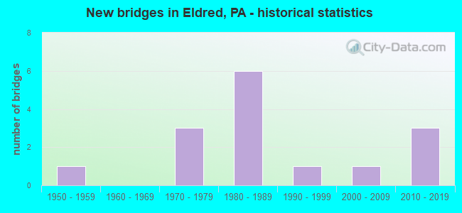
- New bridges - historical statistics
- 11950-1959
- 31970-1979
- 61980-1989
- 11990-1999
- 12000-2009
- 32010-2019
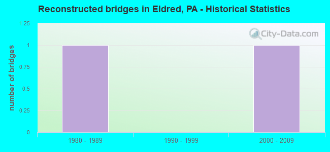
- Reconstructed bridges - Historical Statistics
- 11980-1989
- 01990-1999
- 12000-2009
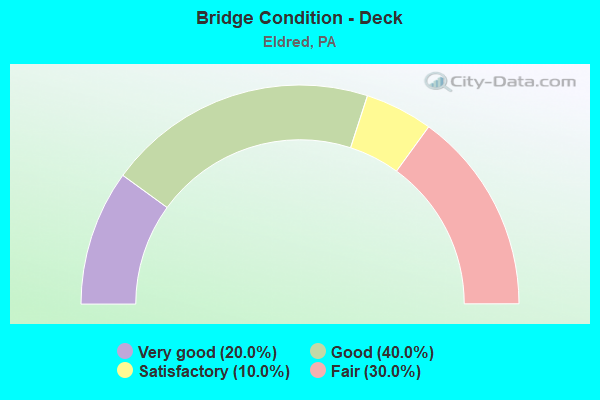
- Bridge Condition - Deck
- 20.0%Very good
- 40.0%Good
- 10.0%Satisfactory
- 30.0%Fair
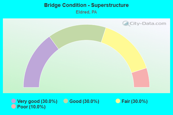
- Bridge Condition - Superstructure
- 30.0%Very good
- 30.0%Good
- 30.0%Fair
- 10.0%Poor
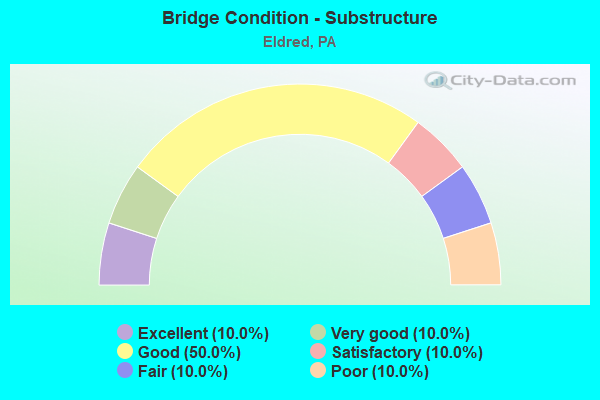
- Bridge Condition - Substructure
- 10.0%Excellent
- 10.0%Very good
- 50.0%Good
- 10.0%Satisfactory
- 10.0%Fair
- 10.0%Poor
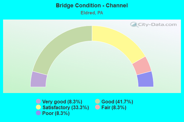
- Bridge Condition - Channel
- 8.3%Very good
- 41.7%Good
- 33.3%Satisfactory
- 8.3%Fair
- 8.3%Poor
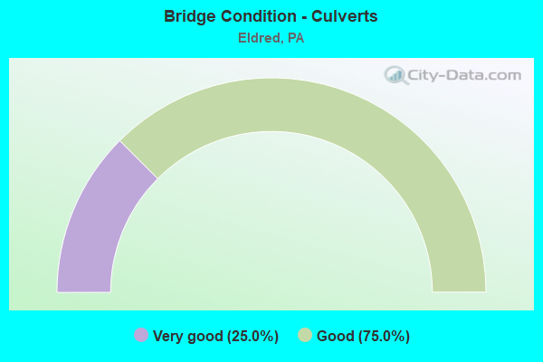
- Bridge Condition - Culverts
- 25.0%Very good
- 75.0%Good
Find on map >> Show street view
Structure Number: 25435, Location: ELDRED BORO (Lat: 41.965142, Lng: -78.385489), Route carried "on" structure: State highway 346, Year Built: 1975, Status: Open, Structure Length: 13.14m (43.11ft), Average Daily Traffic: 3,223 (year 2021), Truck Traffic: 7%, Average Future Daily Traffic: 4,737 (year 2041), Design Load: HS 20, Features Intersected: T398/WESTERN NY & PA RR
Minimum Vertical Clearance: 30+ m (98+ ft), Kilometerpoint: 49.402, Lanes on structure: 2, Lanes under structure: 2, Owner: State Highway Agency, Approaching Roadway Width: 7.3m (24.0ft), Material/Design: Steel continuous, Design/Construction: Stringer/Multi-beam, Number Of Spans In Main Unit: 4, Length of Maximum Span: 46.9m (153.9ft), Curb or Sidewalk Widths: Left: 0.2m (0.7ft), Right: 0.2m (0.7ft), Curb-To-Curb Width: 13.4m (44.0ft), Out-to-Out Width: 14.5m (47.6ft)
Condition: Deck: Fair, Superstructure: Fair, Substructure: Fair, Channel: Very good, Operating Rating: 78.0 metric tons, Method Used To Determine Operating Rating: Load Factor (LF), Inventory Rating: 46.3 metric tons, Method Used To Determine Inventory Rating: Load Factor (LF), Structural Evaluation: Somewhat better than minimum adequacy, Deck Geometry: Better than present minimum criteria, Underclear: High priority of corrective action, Waterway Adequacy: Superior to present desirable criteria, Approach Roadway Alignment: Equal to present minimum criteria, Length Of Structure Improvement: 13.10m (42.98ft), Designated Inspection Frequency: Every 24 months, Inspection Date: August 2021, Bridge Improvement Cost: $90,000, Roadway Improvement Cost: $264,000, Total Project Cost: $1,210,000, Deck Structure Type: Concrete Cast-file-Place, Wearing Surface/Protective System: Wearing Surface: Latex Concrete
Find on map >> Show street view
Structure Number: 25442, Location: 1 MI S LARABEE (Lat: 41.901400, Lng: -78.384353), Route carried "on" structure: State highway 446, Year Built: 1986, Status: Open, Structure Length: 6.07m (19.91ft), Average Daily Traffic: 1,698 (year 2021), Truck Traffic: 19%, Average Future Daily Traffic: 2,603 (year 2041), Design Load: HS 25 or greater, Features Intersected: ALLEGHENY RIVER
Minimum Vertical Clearance: 30+ m (98+ ft), Kilometerpoint: 7.356, Lanes on structure: 2, Base Highway Network: Yes, Owner: State Highway Agency, Approaching Roadway Width: 9.8m (32.2ft), Material/Design: Prestressed concrete, Design/Construction: Box Beam or Girders - Multiple, Number Of Spans In Main Unit: 3, Length of Maximum Span: 19.8m (65.0ft), Curb or Sidewalk Widths: Left: 0.2m (0.7ft), Right: 0.2m (0.7ft), Curb-To-Curb Width: 12.8m (42.0ft), Out-to-Out Width: 13.9m (45.6ft)
Condition: Deck: Satisfactory, Superstructure: Good, Substructure: Good, Channel: Fair, Inventory Rating: 49.9 metric tons, Method Used To Determine Inventory Rating: Load Factor (LF), Structural Evaluation: Better than present minimum criteria, Deck Geometry: Better than present minimum criteria, Waterway Adequacy: Equal to present desirable criteria, Approach Roadway Alignment: Equal to present desirable criteria, Length Of Structure Improvement: 6.10m (20.01ft), Designated Inspection Frequency: Every 24 months, Underwater Inspection Frequency: Every 60 months, Inspection Date: August 2021, Underwater Inspection Date: September 2019, Deck Structure Type: Concrete Cast-file-Place, Wearing Surface/Protective System: Wearing Surface: Monolithic Concrete, Deck Protection: Epoxy Coated Reinforcing
Find on map >> Show street view
Structure Number: 25443, Location: 1 MI S LARABEE (Lat: 41.904164, Lng: -78.380050), Route carried "on" structure: State highway 446, Year Built: 1986, Status: Open, Structure Length: 1.89m (6.20ft), Average Daily Traffic: 1,698 (year 2021), Truck Traffic: 19%, Average Future Daily Traffic: 2,603 (year 2041), Design Load: HS 25 or greater, Features Intersected: WESTERN NY & PA RR
Minimum Vertical Clearance: 30+ m (98+ ft), Kilometerpoint: 8.082, Lanes on structure: 2, Base Highway Network: Yes, Owner: State Highway Agency, Approaching Roadway Width: 9.8m (32.2ft), Skew: 3 degrees, Material/Design: Prestressed concrete, Design/Construction: Box Beam or Girders - Multiple, Number Of Spans In Main Unit: 1, Length of Maximum Span: 18.3m (60.0ft), Curb-To-Curb Width: 12.8m (42.0ft), Out-to-Out Width: 13.9m (45.6ft)
Condition: Deck: Good, Superstructure: Good, Substructure: Good, Inventory Rating: 48.1 metric tons, Method Used To Determine Inventory Rating: Load Factor (LF), Structural Evaluation: Better than present minimum criteria, Deck Geometry: Better than present minimum criteria, Underclear: High priority of corrective action, Approach Roadway Alignment: Equal to present desirable criteria, Length Of Structure Improvement: 1.90m (6.23ft), Designated Inspection Frequency: Every 24 months, Inspection Date: August 2021, Deck Structure Type: Concrete Cast-file-Place, Wearing Surface/Protective System: Wearing Surface: Monolithic Concrete, Deck Protection: Epoxy Coated Reinforcing
Find on map >> Show street view
Structure Number: 25449, Location: ELDRED BORO (Lat: 41.954028, Lng: -78.384892), Route carried "on" structure: State highway 446, Year Built: 1988, Status: Open, Structure Length: 0.61m (2.00ft), Average Daily Traffic: 2,685 (year 2020), Truck Traffic: 10%, Average Future Daily Traffic: 3,785 (year 2041), Design Load: HS 20, Features Intersected: BARDEN BROOK
Minimum Vertical Clearance: 30+ m (98+ ft), Kilometerpoint: 13.967, Lanes on structure: 2, Base Highway Network: Yes, Owner: State Highway Agency, Approaching Roadway Width: 6.7m (22.0ft), Material/Design: Concrete, Design/Construction: Culvert, Number Of Spans In Main Unit: 1, Length of Maximum Span: 6.1m (20.0ft)
Condition: Channel: Good, Culverts: Good, Operating Rating: 54.4 metric tons, Method Used To Determine Operating Rating: Field evaluation and documented engineering judgment, Inventory Rating: 32.7 metric tons, Method Used To Determine Inventory Rating: Field evaluation and documented engineering judgment, Structural Evaluation: Better than present minimum criteria, Waterway Adequacy: Superior to present desirable criteria, Approach Roadway Alignment: Equal to present desirable criteria, Length Of Structure Improvement: 0.60m (1.97ft), Designated Inspection Frequency: Every 24 months, Inspection Date: August 2021
Find on map >> Show street view
Structure Number: 25451, Location: BULLIS MILLS (Lat: 41.984308, Lng: -78.351978), Route carried "on" structure: State highway 446, Year Built: 1953, Year Reconstructed: 2006, Status: Open, Structure Length: 0.76m (2.49ft), Average Daily Traffic: 2,387 (year 2020), Truck Traffic: 11%, Average Future Daily Traffic: 3,697 (year 2041), Design Load: HL 93, Features Intersected: MCCREA RUN
Minimum Vertical Clearance: 30+ m (98+ ft), Kilometerpoint: 19.322, Lanes on structure: 2, Base Highway Network: Yes, Owner: State Highway Agency, Approaching Roadway Width: 9.8m (32.2ft), Material/Design: Prestressed concrete, Design/Construction: Box Beam or Girders - Multiple, Number Of Spans In Main Unit: 1, Length of Maximum Span: 7.0m (23.0ft), Curb-To-Curb Width: 11.4m (37.4ft), Out-to-Out Width: 12.0m (39.4ft)
Condition: Deck: Very good, Superstructure: Good, Substructure: Satisfactory, Channel: Satisfactory, Inventory Rating: 85.3 metric tons, Method Used To Determine Inventory Rating: Load Factor (LF), Structural Evaluation: Equal to present minimum criteria, Deck Geometry: Somewhat better than minimum adequacy, Waterway Adequacy: Equal to present minimum criteria, Approach Roadway Alignment: Equal to present desirable criteria, Designated Inspection Frequency: Every 24 months, Inspection Date: August 2021, Deck Structure Type: Other, Wearing Surface/Protective System: Wearing Surface: Monolithic Concrete, Deck Protection: Epoxy Coated Reinforcing
Find on map >> Show street view
Structure Number: 25486, Location: 1 MI NW ELDRED (Lat: 41.976706, Lng: -78.401042), Route carried "on" structure: State highway , Year Built: 1986, Status: Open, Structure Length: 1.19m (3.90ft), Average Daily Traffic: 1,741 (year 2022), Truck Traffic: 2%, Average Future Daily Traffic: 2,565 (year 2041), Design Load: H 15, Features Intersected: INDIAN CREEK, Facility Carried by Structure: SR 1011
Minimum Vertical Clearance: 30+ m (98+ ft), Kilometerpoint: 1.595, Lanes on structure: 2, Owner: State Highway Agency, Approaching Roadway Width: 9.1m (29.9ft), Skew: 3 degrees, Material/Design: Concrete, Design/Construction: Culvert, Number Of Spans In Main Unit: 2, Length of Maximum Span: 5.8m (19.0ft), Curb or Sidewalk Widths: Left: 0.2m (0.7ft), Right: 0.2m (0.7ft), Curb-To-Curb Width: 12.0m (39.4ft), Out-to-Out Width: 13.2m (43.3ft)
Condition: Channel: Satisfactory, Culverts: Good, Operating Rating: 68.0 metric tons, Method Used To Determine Operating Rating: Load Factor (LF), Inventory Rating: 40.8 metric tons, Method Used To Determine Inventory Rating: Load Factor (LF), Structural Evaluation: Better than present minimum criteria, Deck Geometry: Equal to present minimum criteria, Waterway Adequacy: Equal to present desirable criteria, Approach Roadway Alignment: Equal to present desirable criteria, Length Of Structure Improvement: 1.20m (3.94ft), Designated Inspection Frequency: Every 24 months, Inspection Date: August 2021
Find on map >> Show street view
Structure Number: 25494, Location: ELDRED BORO (Lat: 41.965508, Lng: -78.384944), Route carried "on" structure: State highway , Year Built: 1975, Status: Open, Structure Length: 7.44m (24.41ft), Average Daily Traffic: 78 (year 2020), Truck Traffic: 10%, Average Future Daily Traffic: 104 (year 2041), Design Load: HS 20, Features Intersected: LAND, Facility Carried by Structure: ON DUFFYTOWN ROAD
Minimum Vertical Clearance: 30+ m (98+ ft), Kilometerpoint: 0.000, Lanes on structure: 2, Owner: State Highway Agency, Approaching Roadway Width: 6.4m (21.0ft), Material/Design: Steel continuous, Design/Construction: Stringer/Multi-beam, Number Of Spans In Main Unit: 3, Length of Maximum Span: 27.4m (89.9ft), Curb or Sidewalk Widths: Left: 0.2m (0.7ft), Right: 0.2m (0.7ft), Curb-To-Curb Width: 8.5m (27.9ft), Out-to-Out Width: 9.6m (31.5ft)
Condition: Deck: Good, Superstructure: Fair, Substructure: Good, Operating Rating: 36.3 metric tons, Method Used To Determine Operating Rating: Load Factor (LF), Inventory Rating: 21.8 metric tons, Method Used To Determine Inventory Rating: Load Factor (LF), Structural Evaluation: Somewhat better than minimum adequacy, Deck Geometry: Better than present minimum criteria, Approach Roadway Alignment: Equal to present minimum criteria, Length Of Structure Improvement: 7.40m (24.28ft), Designated Inspection Frequency: Every 24 months, Inspection Date: August 2021, Deck Structure Type: Concrete Cast-file-Place, Wearing Surface/Protective System: Wearing Surface: Monolithic Concrete
Find on map >> Show street view
Structure Number: 25555, Location: AT NEWELL CREEK RD (Lat: 41.894569, Lng: -78.349058), Route carried "on" structure: City street , Year Built: 1982, Year Reconstructed: 1993, Status: Posted for load, Structure Length: 1.01m (3.31ft), Average Daily Traffic: 280 (year 2018), Average Future Daily Traffic: 300 (year 2038), Design Load: HS 20, Features Intersected: NEWELL CREEK, Facility Carried by Structure: T-389 SARTWELL RD
Minimum Vertical Clearance: 30+ m (98+ ft), Kilometerpoint: 0.000, Lanes on structure: 2, Owner: Town or Township Highway Agency, Approaching Roadway Width: 5.2m (17.1ft), Skew: 2 degrees, Material/Design: Steel, Design/Construction: Stringer/Multi-beam, Number Of Spans In Main Unit: 1, Length of Maximum Span: 8.8m (28.9ft), Curb-To-Curb Width: 7.5m (24.6ft), Out-to-Out Width: 8.5m (27.9ft)
Condition: Deck: Fair, Superstructure: Poor, Substructure: Poor, Channel: Poor, Operating Rating: 7.3 metric tons, Method Used To Determine Operating Rating: Allowable Stress (AS), Inventory Rating: 5.4 metric tons, Method Used To Determine Inventory Rating: Allowable Stress (AS), Structural Evaluation: High priority of replacement, Deck Geometry: Somewhat better than minimum adequacy, Waterway Adequacy: Better than present minimum criteria, Approach Roadway Alignment: Equal to present desirable criteria, Bridge Posting: Required (Relationship of Operating Rating to Maximum Legal Load: > 39.9% below), Length Of Structure Improvement: 1.10m (3.61ft), Designated Inspection Frequency: Every 24 months, Other Special Inspection Frequency: Every 12 months, Inspection Date: August 2020, Other Special Inspection Date: August 2021, Bridge Improvement Cost: $27,000, Roadway Improvement Cost: $150,000, Total Project Cost: $362,000, Deck Structure Type: Open Grating
Find on map >> Show street view
Structure Number: 25556, Location: 300 FT WEST OF SR 346 (Lat: 41.954797, Lng: -78.406700), Route carried "on" structure: City street , Year Built: 1996, Status: Open, Structure Length: 2.23m (7.32ft), Average Daily Traffic: 150 (year 2016), Truck Traffic: 7%, Average Future Daily Traffic: 175 (year 2036), Design Load: H 20, Features Intersected: KNAPP CREEK, Facility Carried by Structure: T-395 WIND FALL RD
Minimum Vertical Clearance: 30+ m (98+ ft), Kilometerpoint: 0.000, Lanes on structure: 2, Owner: Town or Township Highway Agency, Approaching Roadway Width: 4.9m (16.1ft), Material/Design: Steel, Design/Construction: Stringer/Multi-beam, Number Of Spans In Main Unit: 1, Length of Maximum Span: 20.4m (66.9ft), Curb-To-Curb Width: 5.2m (17.1ft), Out-to-Out Width: 5.5m (18.0ft)
Condition: Deck: Fair, Superstructure: Fair, Substructure: Good, Channel: Satisfactory, Operating Rating: 50.8 metric tons, Method Used To Determine Operating Rating: Load Factor (LF), Inventory Rating: 30.8 metric tons, Method Used To Determine Inventory Rating: Load Factor (LF), Structural Evaluation: Somewhat better than minimum adequacy, Deck Geometry: High priority of replacement, Waterway Adequacy: Equal to present desirable criteria, Approach Roadway Alignment: Meets minimum limits, Length Of Structure Improvement: 2.20m (7.22ft), Designated Inspection Frequency: Every 24 months, Inspection Date: August 2020, Deck Structure Type: Open Grating
Find on map >> Show street view
Structure Number: 25617, Location: 350 FT N OF MECHANIC ST (Lat: 41.954000, Lng: -78.382697), Route carried "on" structure: City street , Year Built: 1987, Status: Open, Structure Length: 0.61m (2.00ft), Average Daily Traffic: 200 (year 2018), Truck Traffic: 10%, Average Future Daily Traffic: 250 (year 2038), Design Load: HS 20, Features Intersected: BARDEN BROOK, Facility Carried by Structure: BENNETT STREET
Minimum Vertical Clearance: 30+ m (98+ ft), Kilometerpoint: 0.000, Lanes on structure: 2, Owner: City or Municipal Highway Agency, Approaching Roadway Width: 8.5m (27.9ft), Material/Design: Concrete, Design/Construction: Culvert, Number Of Spans In Main Unit: 1, Length of Maximum Span: 6.1m (20.0ft), Curb or Sidewalk Widths: Left: 1.4m (4.6ft), Right: 0.0m
Condition: Channel: Good, Culverts: Good, Operating Rating: 54.4 metric tons, Method Used To Determine Operating Rating: Field evaluation and documented engineering judgment, Inventory Rating: 32.7 metric tons, Method Used To Determine Inventory Rating: Field evaluation and documented engineering judgment, Structural Evaluation: Better than present minimum criteria, Waterway Adequacy: Superior to present desirable criteria, Approach Roadway Alignment: Equal to present desirable criteria, Length Of Structure Improvement: 1.20m (3.94ft), Designated Inspection Frequency: Every 24 months, Inspection Date: August 2020
Find on map >> Show street view
Structure Number: 42197, Location: 1 MILE WEST OF ELDRED (Lat: 41.963597, Lng: -78.400528), Route carried "on" structure: State highway , Year Built: 2003, Status: Open, Structure Length: 4.05m (13.29ft), Average Daily Traffic: 1,741 (year 2022), Truck Traffic: 2%, Average Future Daily Traffic: 2,565 (year 2041), Design Load: HL 93, Features Intersected: KNAPP CREEK, Facility Carried by Structure: SR 1011
Minimum Vertical Clearance: 30+ m (98+ ft), Kilometerpoint: 0.011, Lanes on structure: 2, Owner: State Highway Agency, Approaching Roadway Width: 10.4m (34.1ft), Material/Design: Prestressed concrete, Design/Construction: Stringer/Multi-beam, Number Of Spans In Main Unit: 1, Length of Maximum Span: 38.4m (126.0ft), Curb or Sidewalk Widths: Left: 0.2m (0.7ft), Right: 0.2m (0.7ft), Curb-To-Curb Width: 11.0m (36.1ft), Out-to-Out Width: 11.8m (38.7ft)
Condition: Deck: Good, Superstructure: Very good, Substructure: Good, Channel: Good, Operating Rating: 89.8 metric tons, Method Used To Determine Operating Rating: Load Factor (LF), Inventory Rating: 45.4 metric tons, Method Used To Determine Inventory Rating: Load Factor (LF), Structural Evaluation: Better than present minimum criteria, Deck Geometry: Equal to present minimum criteria, Waterway Adequacy: Superior to present desirable criteria, Approach Roadway Alignment: Equal to present desirable criteria, Length Of Structure Improvement: 4.90m (16.08ft), Designated Inspection Frequency: Every 24 months, Inspection Date: August 2021, Deck Structure Type: Concrete Cast-file-Place, Wearing Surface/Protective System: Wearing Surface: Monolithic Concrete, Deck Protection: Epoxy Coated Reinforcing
Find on map >> Show street view
Structure Number: 46254, Location: PRENTISVALE (Lat: 41.934150, Lng: -78.442750), Route carried "on" structure: State highway 346, Year Built: 2010, Status: Open, Structure Length: 2.59m (8.50ft), Average Daily Traffic: 808 (year 2022), Truck Traffic: 5%, Average Future Daily Traffic: 1,386 (year 2041), Design Load: HL 93, Features Intersected: KNAPP CREEK
Minimum Vertical Clearance: 30+ m (98+ ft), Kilometerpoint: 42.530, Lanes on structure: 2, Owner: State Highway Agency, Approaching Roadway Width: 8.5m (27.9ft), Skew: 3 degrees, Material/Design: Prestressed concrete, Design/Construction: Box Beam or Girders - Single/Spread, Number Of Spans In Main Unit: 1, Length of Maximum Span: 25.6m (84.0ft), Curb or Sidewalk Widths: Left: 0.2m (0.7ft), Right: 0.2m (0.7ft), Curb-To-Curb Width: 8.5m (27.9ft), Out-to-Out Width: 9.6m (31.5ft)
Condition: Deck: Good, Superstructure: Very good, Substructure: Very good, Channel: Satisfactory, Operating Rating: 68.9 metric tons, Method Used To Determine Operating Rating: Load and Resistance Factor (LRFR), Inventory Rating: 41.7 metric tons, Method Used To Determine Inventory Rating: Load and Resistance Factor (LRFR), Structural Evaluation: Equal to present desirable criteria, Deck Geometry: Somewhat better than minimum adequacy, Waterway Adequacy: Equal to present desirable criteria, Approach Roadway Alignment: Better than present minimum criteria, Designated Inspection Frequency: Every 24 months, Inspection Date: September 2021, Deck Structure Type: Concrete Cast-file-Place, Wearing Surface/Protective System: Wearing Surface: Monolithic Concrete, Deck Protection: Epoxy Coated Reinforcing
Find on map >> Show street view
Structure Number: 4879, Location: 2 MI NW ELDRED (Lat: 41.984394, Lng: -78.401464), Route carried "on" structure: State highway , Year Built: 2014, Status: Open, Structure Length: 0.64m (2.10ft), Average Daily Traffic: 1,741 (year 2022), Truck Traffic: 2%, Average Future Daily Traffic: 2,565 (year 2041), Design Load: HL 93, Features Intersected: MIX CREEK, Facility Carried by Structure: SR 1011
Minimum Vertical Clearance: 30+ m (98+ ft), Kilometerpoint: 2.488, Lanes on structure: 2, Owner: State Highway Agency, Approaching Roadway Width: 6.7m (22.0ft), Skew: 3 degrees, Material/Design: Concrete, Design/Construction: Culvert, Number Of Spans In Main Unit: 1, Length of Maximum Span: 6.4m (21.0ft), Curb-To-Curb Width: 7.9m (25.9ft), Out-to-Out Width: 12.2m (40.0ft)
Condition: Channel: Good, Culverts: Very good, Operating Rating: 57.7 metric tons, Method Used To Determine Operating Rating: Assigned ratings based on Load and Resistance Factor Design (LRFD) reported by rating factor (RF) using HL93 loadings, Inventory Rating: 36.3 metric tons, Method Used To Determine Inventory Rating: Assigned ratings based on Load and Resistance Factor Design (LRFD) reported by rating factor (RF) using HL93 loadings, Structural Evaluation: Equal to present desirable criteria, Deck Geometry: Meets minimum limits, Waterway Adequacy: Equal to present desirable criteria, Approach Roadway Alignment: Equal to present desirable criteria, Designated Inspection Frequency: Every 24 months, Inspection Date: August 2021
Find on map >> Show street view
Structure Number: 53927, Location: 7MI NW of Port Allegheny (Lat: 41.889914, Lng: -78.352408), Route carried "on" structure: State highway 155, Year Built: 2017, Status: Open, Structure Length: 1.92m (6.30ft), Average Daily Traffic: 2,388 (year 2020), Truck Traffic: 15%, Average Future Daily Traffic: 2,519 (year 2037), Design Load: HL 93, Features Intersected: Newell Creek
Minimum Vertical Clearance: 30+ m (98+ ft), Kilometerpoint: 22.936, Lanes on structure: 2, Owner: State Highway Agency, Maintenance Responsibility: Private, Approaching Roadway Width: 9.8m (32.2ft), Material/Design: Steel, Number Of Spans In Main Unit: 1, Length of Maximum Span: 18.0m (59.1ft), Curb-To-Curb Width: 12.5m (41.0ft), Out-to-Out Width: 13.1m (43.0ft)
Condition: Deck: Very good, Superstructure: Very good, Substructure: Excellent, Channel: Good, Operating Rating: 67.1 metric tons, Method Used To Determine Operating Rating: Assigned ratings based on Load and Resistance Factor Design (LRFD) reported by rating factor (RF) using HL93 loadings, Inventory Rating: 51.5 metric tons, Method Used To Determine Inventory Rating: Assigned ratings based on Load and Resistance Factor Design (LRFD) reported by rating factor (RF) using HL93 loadings, Structural Evaluation: Equal to present desirable criteria, Deck Geometry: Equal to present minimum criteria, Waterway Adequacy: Superior to present desirable criteria, Approach Roadway Alignment: Equal to present desirable criteria, Designated Inspection Frequency: Every 24 months, Inspection Date: June 2021, Deck Structure Type: Concrete Cast-file-Place, Wearing Surface/Protective System: Wearing Surface: Integral Concrete, Deck Protection: Epoxy Coated Reinforcing
Find on map >> Show street view
Structure Number: 25435, Location: ELDRED BORO (Lat: 41.965142, Lng: -78.385489), Route carried "under" structure: County highway , Year Built: 1975, Structure Length: 0. m, Average Daily Traffic: 50 (year 2003), Features Intersected: T398/WESTERN NY & PA RR, Facility Carried by Structure: SR 346-PA 346
Minimum Vertical Clearance: 9.14m (29.99ft), Kilometerpoint: 0.000, Lanes on structure: 2, Lanes under structure: 2, Material/Design: Steel continuous, Design/Construction: Stringer/Multi-beam, Length of Maximum Span: 46.9m (153.9ft)