Bridge Statistics for Elgin, Oklahoma (OK)
Condition, Traffic, Stress, Structural Evaluation, Project Costs
- National Bridge Inventory (NBI) Statistics
- 23Number of bridges
- 171ft / 51.7mTotal length
- $15,149,000Total costs
- 116,301Total average daily traffic
- 35,220Total average daily truck traffic
- National Bridge Inventory (NBI) Registered Bridges for Elgin
- No street view available for this location
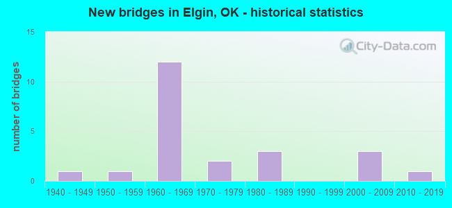
- New bridges - historical statistics
- 11940-1949
- 11950-1959
- 121960-1969
- 21970-1979
- 31980-1989
- 32000-2009
- 12010-2019


- Bridge Condition - Deck
- 66.7%Good
- 13.3%Satisfactory
- 20.0%Fair

- Bridge Condition - Superstructure
- 13.3%Very good
- 40.0%Good
- 20.0%Satisfactory
- 26.7%Fair

- Bridge Condition - Substructure
- 6.7%Very good
- 26.7%Good
- 46.7%Satisfactory
- 20.0%Fair

- Bridge Condition - Channel
- 15.4%Very good
- 46.2%Good
- 23.1%Satisfactory
- 15.4%Fair

- Bridge Condition - Culverts
- 33.3%Very good
- 33.3%Satisfactory
- 33.3%Fair
Find on map >> Show street view
Structure Number: 10678, Location: 2.2 MI.E.JCT.US277 (Lat: 34.777797, Lng: -98.257658), Route carried "on" structure: State highway 17, Year Built: 1947, Status: Open, Structure Length: 1.28m (4.20ft), Average Daily Traffic: 2,000 (year 2020), Truck Traffic: 15%, Average Future Daily Traffic: 3,200 (year 2040), Design Load: H 20, Features Intersected: CREEK
Minimum Vertical Clearance: 30+ m (98+ ft), Kilometerpoint: 3.475, Lanes on structure: 2, Owner: State Highway Agency, Approaching Roadway Width: 9.8m (32.2ft), Material/Design: Concrete, Design/Construction: Culvert, Number Of Spans In Main Unit: 3, Length of Maximum Span: 4.3m (14.1ft), Curb-To-Curb Width: 9.8m (32.2ft), Out-to-Out Width: 10.4m (34.1ft)
Condition: Channel: Good, Culverts: Fair, Operating Rating: 44.5 metric tons, Method Used To Determine Operating Rating: Allowable Stress (AS), Inventory Rating: 32.7 metric tons, Method Used To Determine Inventory Rating: Allowable Stress (AS), Structural Evaluation: Somewhat better than minimum adequacy, Deck Geometry: Somewhat better than minimum adequacy, Waterway Adequacy: Equal to present desirable criteria, Approach Roadway Alignment: Equal to present desirable criteria, Length Of Structure Improvement: 1.28m (4.20ft), Designated Inspection Frequency: Every 24 months, Inspection Date: March 2021, Bridge Improvement Cost: $230,000, Roadway Improvement Cost: $380,000, Total Project Cost: $644,000 ( Estimate for 2015)
Find on map >> Show street view
Structure Number: 14306, Location: .7S&1.5E OF JCT US277&17 (Lat: 34.774022, Lng: -98.265544), Route carried "on" structure: County highway 1604, Year Built: 1959, Status: Open, Structure Length: 1.22m (4.00ft), Average Daily Traffic: 646 (year 2020), Truck Traffic: 15%, Average Future Daily Traffic: 1,034 (year 2040), Design Load: HS 20, Features Intersected: CREEK, Facility Carried by Structure: 1658C
Minimum Vertical Clearance: 30+ m (98+ ft), Kilometerpoint: 19.792, Lanes on structure: 2, Owner: County Highway Agency, Approaching Roadway Width: 9.8m (32.2ft), Skew: 3 degrees, Material/Design: Concrete, Design/Construction: Culvert, Number Of Spans In Main Unit: 3, Length of Maximum Span: 4.3m (14.1ft), Curb-To-Curb Width: 9.8m (32.2ft), Out-to-Out Width: 9.8m (32.2ft)
Condition: Channel: Satisfactory, Culverts: Satisfactory, Operating Rating: 37.2 metric tons, Method Used To Determine Operating Rating: Load Factor (LF), Inventory Rating: 21.8 metric tons, Method Used To Determine Inventory Rating: Load Factor (LF), Structural Evaluation: Somewhat better than minimum adequacy, Deck Geometry: Equal to present minimum criteria, Waterway Adequacy: Better than present minimum criteria, Approach Roadway Alignment: Equal to present desirable criteria, Length Of Structure Improvement: 3.83m (12.57ft), Designated Inspection Frequency: Every 24 months, Inspection Date: August 2021, Bridge Improvement Cost: $100,000, Roadway Improvement Cost: $75,000, Total Project Cost: $225,000 ( Estimate for 2015), Deck Structure Type: Concrete Cast-file-Place, Wearing Surface/Protective System: Wearing Surface: Bituminous
Find on map >> Show street view
Structure Number: 15903, Location: T.P. BR.NO.54.75 (Lat: 34.777519, Lng: -98.308161), Route carried "on" structure: Interstate 44, Year Built: 1964, Status: Open, Structure Length: 0.81m (2.66ft), Average Daily Traffic: 16,200 (year 2020), Truck Traffic: 36%, Average Future Daily Traffic: 25,920 (year 2040), Design Load: HS 20, Features Intersected: CREEK
Minimum Vertical Clearance: 30+ m (98+ ft), Kilometerpoint: 10.298, Lanes on structure: 4, Base Highway Network: Yes, Toll: On toll road, Owner: State Toll Authority, Approaching Roadway Width: 24.7m (81.0ft), Skew: 22 degrees, Material/Design: Concrete, Design/Construction: Culvert, Number Of Spans In Main Unit: 2, Length of Maximum Span: 3.7m (12.1ft), Curb-To-Curb Width: 44.5m (146.0ft), Out-to-Out Width: 45.1m (148.0ft)
Condition: Channel: Good, Culverts: Very good, Operating Rating: 44.5 metric tons, Method Used To Determine Operating Rating: Load Factor (LF), Inventory Rating: 32.7 metric tons, Method Used To Determine Inventory Rating: Load Factor (LF), Structural Evaluation: Equal to present desirable criteria, Deck Geometry: Superior to present desirable criteria, Waterway Adequacy: Equal to present desirable criteria, Approach Roadway Alignment: Equal to present desirable criteria, Length Of Structure Improvement: 3.11m (10.20ft), Designated Inspection Frequency: Every 24 months, Inspection Date: June 2021, Bridge Improvement Cost: $200,000, Roadway Improvement Cost: $150,000, Total Project Cost: $360,000 ( Estimate for 2015)
Find on map >> Show street view
Structure Number: 16002, Location: T P BR NO 57.12 (Lat: 34.759564, Lng: -98.343011), Route carried "on" structure: Interstate 44, Year Built: 1964, Status: Open, Structure Length: 3.29m (10.79ft), Average Daily Traffic: 16,200 (year 2020), Truck Traffic: 36%, Average Future Daily Traffic: 25,920 (year 2040), Design Load: HS 20, Features Intersected: FORT SILL RANGE RD UNDER
Minimum Vertical Clearance: 30+ m (98+ ft), Kilometerpoint: 6.436, Lanes on structure: 4, Lanes under structure: 2, Base Highway Network: Yes, Toll: On toll road, Owner: State Toll Authority, Approaching Roadway Width: 24.7m (81.0ft), Skew: 30 degrees, Material/Design: Steel, Design/Construction: Stringer/Multi-beam, Number Of Spans In Main Unit: 3, Length of Maximum Span: 12.2m (40.0ft), Curb-To-Curb Width: 25.3m (83.0ft), Out-to-Out Width: 26.8m (87.9ft)
Condition: Deck: Good, Superstructure: Good, Substructure: Good, Operating Rating: 44.5 metric tons, Method Used To Determine Operating Rating: Allowable Stress (AS), Inventory Rating: 32.7 metric tons, Method Used To Determine Inventory Rating: Allowable Stress (AS), Structural Evaluation: Better than present minimum criteria, Deck Geometry: Superior to present desirable criteria, Underclear: High priority of replacement, Approach Roadway Alignment: Equal to present desirable criteria, Length Of Structure Improvement: 3.29m (10.79ft), Designated Inspection Frequency: Every 24 months, Inspection Date: June 2021, Bridge Improvement Cost: $411,000, Roadway Improvement Cost: $617,000, Total Project Cost: $1,183,000 ( Estimate for 2015), Deck Structure Type: Concrete Cast-file-Place, Wearing Surface/Protective System: Wearing Surface: Monolithic Concrete
Find on map >> Show street view
Structure Number: 16058, Location: T P BR NO 53.18 (Lat: 34.796047, Lng: -98.291097), Route carried "on" structure: County highway E1530, Year Built: 1964, Status: Open, Structure Length: 4.79m (15.72ft), Average Daily Traffic: 5,000 (year 2020), Truck Traffic: 15%, Average Future Daily Traffic: 8,000 (year 2040), Design Load: H 15, Features Intersected: BAILEY A TP (I-44) UNDER
Minimum Vertical Clearance: 30+ m (98+ ft), Kilometerpoint: 12.872, Lanes on structure: 2, Lanes under structure: 4, Owner: State Toll Authority, Approaching Roadway Width: 6.4m (21.0ft), Material/Design: Steel, Design/Construction: Stringer/Multi-beam, Number Of Spans In Main Unit: 4, Length of Maximum Span: 13.1m (43.0ft), Curb-To-Curb Width: 5.5m (18.0ft), Out-to-Out Width: 7.0m (23.0ft)
Condition: Deck: Satisfactory, Superstructure: Good, Substructure: Satisfactory, Operating Rating: 41.7 metric tons, Method Used To Determine Operating Rating: Load Factor (LF), Inventory Rating: 24.5 metric tons, Method Used To Determine Inventory Rating: Load Factor (LF), Structural Evaluation: Equal to present minimum criteria, Deck Geometry: High priority of replacement, Underclear: High priority of replacement, Approach Roadway Alignment: Somewhat better than minimum adequacy, Length Of Structure Improvement: 4.79m (15.72ft), Designated Inspection Frequency: Every 24 months, Inspection Date: June 2021, Bridge Improvement Cost: $598,000, Roadway Improvement Cost: $897,000, Total Project Cost: $1,713,000 ( Estimate for 2015), Deck Structure Type: Concrete Cast-file-Place, Wearing Surface/Protective System: Wearing Surface: Monolithic Concrete
Find on map >> Show street view
Structure Number: 16074, Location: T.P.BR.NO.51.61 (Lat: 34.805064, Lng: -98.265600), Route carried "on" structure: County highway N2650, Year Built: 1964, Status: Open, Structure Length: 5.03m (16.50ft), Average Daily Traffic: 5,000 (year 2020), Truck Traffic: 15%, Average Future Daily Traffic: 8,000 (year 2040), Design Load: H 15, Features Intersected: BAILEY A TP (I-44) UNDER
Minimum Vertical Clearance: 30+ m (98+ ft), Kilometerpoint: 15.446, Lanes on structure: 2, Lanes under structure: 4, Owner: State Toll Authority, Approaching Roadway Width: 6.4m (21.0ft), Skew: 2 degrees, Material/Design: Steel, Design/Construction: Stringer/Multi-beam, Number Of Spans In Main Unit: 4, Length of Maximum Span: 13.7m (44.9ft), Curb-To-Curb Width: 5.5m (18.0ft), Out-to-Out Width: 7.0m (23.0ft)
Condition: Deck: Good, Superstructure: Good, Substructure: Good, Operating Rating: 43.5 metric tons, Method Used To Determine Operating Rating: Load Factor (LF), Inventory Rating: 25.4 metric tons, Method Used To Determine Inventory Rating: Load Factor (LF), Structural Evaluation: Equal to present minimum criteria, Deck Geometry: High priority of replacement, Underclear: High priority of replacement, Approach Roadway Alignment: Somewhat better than minimum adequacy, Length Of Structure Improvement: 5.03m (16.50ft), Designated Inspection Frequency: Every 24 months, Inspection Date: June 2021, Bridge Improvement Cost: $629,000, Roadway Improvement Cost: $944,000, Total Project Cost: $1,802,000 ( Estimate for 2015), Deck Structure Type: Concrete Cast-file-Place, Wearing Surface/Protective System: Wearing Surface: Monolithic Concrete
Find on map >> Show street view
Structure Number: 16089, Location: T.P. BR.NO.57.83 (Lat: 34.753200, Lng: -98.352589), Route carried "on" structure: County highway N2600, Year Built: 1964, Status: Open, Structure Length: 5.49m (18.01ft), Average Daily Traffic: 5,000 (year 2020), Truck Traffic: 15%, Average Future Daily Traffic: 8,000 (year 2040), Design Load: H 15, Features Intersected: BAILEY A TP (I-44) UNDER
Minimum Vertical Clearance: 30+ m (98+ ft), Kilometerpoint: 5.309, Lanes on structure: 2, Lanes under structure: 4, Owner: State Toll Authority, Approaching Roadway Width: 6.4m (21.0ft), Skew: 3 degrees, Material/Design: Steel, Design/Construction: Stringer/Multi-beam, Number Of Spans In Main Unit: 4, Length of Maximum Span: 14.9m (48.9ft), Curb-To-Curb Width: 5.5m (18.0ft), Out-to-Out Width: 7.0m (23.0ft)
Condition: Deck: Good, Superstructure: Good, Substructure: Good, Operating Rating: 41.7 metric tons, Method Used To Determine Operating Rating: Load Factor (LF), Inventory Rating: 25.4 metric tons, Method Used To Determine Inventory Rating: Load Factor (LF), Structural Evaluation: Equal to present minimum criteria, Deck Geometry: High priority of replacement, Underclear: High priority of replacement, Approach Roadway Alignment: Somewhat better than minimum adequacy, Length Of Structure Improvement: 5.49m (18.01ft), Designated Inspection Frequency: Every 24 months, Inspection Date: June 2021, Bridge Improvement Cost: $687,000, Roadway Improvement Cost: $1,031,000, Total Project Cost: $1,966,000 ( Estimate for 2015), Deck Structure Type: Concrete Cast-file-Place, Wearing Surface/Protective System: Wearing Surface: Monolithic Concrete
Find on map >> Show street view
Structure Number: 16104, Location: 4.8 MI E US62 (Lat: 34.782225, Lng: -98.304719), Route carried "on" structure: Interstate 44, Year Built: 1964, Year Reconstructed: 1990, Status: Open, Structure Length: 5.39m (17.68ft), Average Daily Traffic: 16,200 (year 2020), Truck Traffic: 36%, Average Future Daily Traffic: 25,920 (year 2040), Design Load: HS 20, Features Intersected: U.S. 277 UNDER
Minimum Vertical Clearance: 30+ m (98+ ft), Kilometerpoint: 17.608, Lanes on structure: 4, Lanes under structure: 4, Base Highway Network: Yes, Toll: On toll road, Owner: State Toll Authority, Approaching Roadway Width: 24.7m (81.0ft), Skew: 33 degrees, Material/Design: Steel, Design/Construction: Stringer/Multi-beam, Number Of Spans In Main Unit: 4, Length of Maximum Span: 15.2m (49.9ft), Curb or Sidewalk Widths: Left: 0.5m (1.6ft), Right: 0.5m (1.6ft), Curb-To-Curb Width: 25.3m (83.0ft), Out-to-Out Width: 26.8m (87.9ft)
Condition: Deck: Good, Superstructure: Good, Substructure: Satisfactory, Operating Rating: 44.5 metric tons, Method Used To Determine Operating Rating: Allowable Stress (AS), Inventory Rating: 32.7 metric tons, Method Used To Determine Inventory Rating: Allowable Stress (AS), Structural Evaluation: Equal to present minimum criteria, Deck Geometry: Superior to present desirable criteria, Underclear: Equal to present minimum criteria, Approach Roadway Alignment: Equal to present desirable criteria, Length Of Structure Improvement: 5.39m (17.68ft), Designated Inspection Frequency: Every 24 months, Inspection Date: June 2021, Bridge Improvement Cost: $674,000, Roadway Improvement Cost: $1,011,000, Total Project Cost: $1,928,000 ( Estimate for 2015), Deck Structure Type: Concrete Cast-file-Place, Wearing Surface/Protective System: Wearing Surface: Monolithic Concrete
Find on map >> Show street view
Structure Number: 16233, Location: 2.5E&.6N OF JCT US277&S17 (Lat: 34.791633, Lng: -98.247892), Route carried "on" structure: County highway N2660, Year Built: 1965, Status: Posted for load, Structure Length: 0.70m (2.30ft), Average Daily Traffic: 100 (year 2020), Truck Traffic: 10%, Average Future Daily Traffic: 160 (year 2040), Design Load: H 15, Features Intersected: CREEK
Minimum Vertical Clearance: 30+ m (98+ ft), Kilometerpoint: 0.644, Lanes on structure: 1, Owner: County Highway Agency, Approaching Roadway Width: 4.9m (16.1ft), Material/Design: Steel, Design/Construction: Stringer/Multi-beam, Number Of Spans In Main Unit: 1, Length of Maximum Span: 6.1m (20.0ft), Curb-To-Curb Width: 4.9m (16.1ft), Out-to-Out Width: 4.9m (16.1ft)
Condition: Deck: Good, Superstructure: Fair, Substructure: Satisfactory, Channel: Fair, Operating Rating: 23.6 metric tons, Method Used To Determine Operating Rating: Allowable Stress (AS), Inventory Rating: 18.1 metric tons, Method Used To Determine Inventory Rating: Allowable Stress (AS), Structural Evaluation: Somewhat better than minimum adequacy, Deck Geometry: High priority of corrective action, Waterway Adequacy: Better than present minimum criteria, Approach Roadway Alignment: Equal to present desirable criteria, Bridge Posting: Required (Relationship of Operating Rating to Maximum Legal Load: > 39.9% below), Length Of Structure Improvement: 2.86m (9.38ft), Designated Inspection Frequency: Every 24 months, Inspection Date: August 2021, Bridge Improvement Cost: $146,000, Roadway Improvement Cost: $80,000, Total Project Cost: $230,000 ( Estimate for 2015), Deck Structure Type: Wood or Timber, Wearing Surface/Protective System: Wearing Surface: Wood or Timber
Find on map >> Show street view
Structure Number: 18221, Location: 2.2E OF JCT US277&SH17 (Lat: 34.782686, Lng: -98.253633), Route carried "on" structure: County highway E1540, Year Built: 1972, Status: Posted for load, Structure Length: 1.22m (4.00ft), Average Daily Traffic: 100 (year 2020), Truck Traffic: 10%, Average Future Daily Traffic: 160 (year 2040), Design Load: HS 15, Features Intersected: CREEK
Minimum Vertical Clearance: 30+ m (98+ ft), Kilometerpoint: 1.127, Lanes on structure: 2, Owner: County Highway Agency, Approaching Roadway Width: 5.5m (18.0ft), Skew: 7 degrees, Material/Design: Steel, Design/Construction: Stringer/Multi-beam, Number Of Spans In Main Unit: 1, Length of Maximum Span: 11.0m (36.1ft), Curb-To-Curb Width: 5.5m (18.0ft), Out-to-Out Width: 5.5m (18.0ft)
Condition: Deck: Fair, Superstructure: Fair, Substructure: Fair, Channel: Satisfactory, Operating Rating: 29.0 metric tons, Method Used To Determine Operating Rating: Allowable Stress (AS), Inventory Rating: 21.8 metric tons, Method Used To Determine Inventory Rating: Allowable Stress (AS), Structural Evaluation: Somewhat better than minimum adequacy, Deck Geometry: Meets minimum limits, Waterway Adequacy: Better than present minimum criteria, Approach Roadway Alignment: Somewhat better than minimum adequacy, Bridge Posting: Required (Relationship of Operating Rating to Maximum Legal Load: 30.0 - 39.9% below), Length Of Structure Improvement: 3.83m (12.57ft), Designated Inspection Frequency: Every 24 months, Inspection Date: August 2021, Bridge Improvement Cost: $196,000, Roadway Improvement Cost: $108,000, Total Project Cost: $311,000 ( Estimate for 2015), Deck Structure Type: Wood or Timber, Wearing Surface/Protective System: Wearing Surface: Wood or Timber
Find on map >> Show street view
Structure Number: 19339, Location: 3N&1.5W OF JCT US277&SH17 (Lat: 34.828081, Lng: -98.317028), Route carried "on" structure: County highway 1662C, Year Built: 1977, Status: Posted for load, Structure Length: 3.11m (10.20ft), Average Daily Traffic: 630 (year 2020), Truck Traffic: 15%, Average Future Daily Traffic: 1,008 (year 2040), Features Intersected: CREEK
Minimum Vertical Clearance: 30+ m (98+ ft), Kilometerpoint: 4.987, Lanes on structure: 2, Owner: County Highway Agency, Approaching Roadway Width: 13.0m (42.7ft), Material/Design: Steel, Design/Construction: Truss - Thru, Number Of Spans In Main Unit: 1, Length of Maximum Span: 30.5m (100.1ft), Curb-To-Curb Width: 7.5m (24.6ft), Out-to-Out Width: 7.5m (24.6ft)
Condition: Deck: Fair, Superstructure: Fair, Substructure: Fair, Channel: Satisfactory, Operating Rating: 27.4 metric tons, Method Used To Determine Operating Rating: Load Factor (LF), Inventory Rating: 16.4 metric tons, Method Used To Determine Inventory Rating: Load Factor (LF), Structural Evaluation: Meets minimum limits, Deck Geometry: Meets minimum limits, Waterway Adequacy: Equal to present minimum criteria, Approach Roadway Alignment: Equal to present desirable criteria, Bridge Posting: Required (Relationship of Operating Rating to Maximum Legal Load: 30.0 - 39.9% below), Length Of Structure Improvement: 6.26m (20.54ft), Designated Inspection Frequency: Every 24 months, Critical Feature Inspection Frequency: Every 24 months, Other Special Inspection Frequency: Every 24 months, Inspection Date: November 2021, Critical Feature Inspection Date: November 2021, Other Special Inspection Date: November 2020, Bridge Improvement Cost: $320,000, Roadway Improvement Cost: $176,000, Total Project Cost: $511,000 ( Estimate for 2015), Deck Structure Type: Concrete Cast-file-Place, Wearing Surface/Protective System: Wearing Surface: Monolithic Concrete
Find on map >> Show street view
Structure Number: 19985, Location: 1.1 MI.E. JCT. US62 (Lat: 34.782383, Lng: -98.366922), Route carried "on" structure: US 277, Year Built: 1981, Status: Open, Structure Length: 6.00m (19.69ft), Average Daily Traffic: 3,500 (year 2020), Truck Traffic: 15%, Average Future Daily Traffic: 5,600 (year 2040), Design Load: HS 20, Features Intersected: EAST CACHE CREEK
Minimum Vertical Clearance: 30+ m (98+ ft), Kilometerpoint: 1.851, Lanes on structure: 2, Owner: State Highway Agency, Approaching Roadway Width: 9.1m (29.9ft), Material/Design: Prestressed concrete, Design/Construction: Stringer/Multi-beam, Number Of Spans In Main Unit: 3, Length of Maximum Span: 19.8m (65.0ft), Curb-To-Curb Width: 12.2m (40.0ft), Out-to-Out Width: 13.1m (43.0ft)
Condition: Deck: Fair, Superstructure: Good, Substructure: Satisfactory, Channel: Good, Operating Rating: 66.2 metric tons, Method Used To Determine Operating Rating: Load Factor (LF), Inventory Rating: 39.0 metric tons, Method Used To Determine Inventory Rating: Load Factor (LF), Structural Evaluation: Equal to present minimum criteria, Deck Geometry: Equal to present minimum criteria, Waterway Adequacy: Equal to present desirable criteria, Approach Roadway Alignment: Equal to present desirable criteria, Length Of Structure Improvement: 8.92m (29.27ft), Designated Inspection Frequency: Every 24 months, Inspection Date: March 2021, Bridge Improvement Cost: $725,000, Roadway Improvement Cost: $1,197,000, Total Project Cost: $2,031,000 ( Estimate for 2015), Deck Structure Type: Concrete Cast-file-Place, Wearing Surface/Protective System: Wearing Surface: Monolithic Concrete
Find on map >> Show street view
Structure Number: 21265, Location: .8W&4N OF JCT US277&SH17 (Lat: 34.840386, Lng: -98.304875), Route carried "on" structure: County highway E1500, Year Built: 1986, Status: Posted for load, Structure Length: 1.62m (5.31ft), Average Daily Traffic: 100 (year 2020), Truck Traffic: 10%, Average Future Daily Traffic: 160 (year 2040), Design Load: H 10, Features Intersected: CREEK
Minimum Vertical Clearance: 30+ m (98+ ft), Kilometerpoint: 1.127, Lanes on structure: 2, Owner: County Highway Agency, Approaching Roadway Width: 6.1m (20.0ft), Material/Design: Steel, Design/Construction: Stringer/Multi-beam, Number Of Spans In Main Unit: 1, Length of Maximum Span: 15.2m (49.9ft), Curb-To-Curb Width: 6.1m (20.0ft), Out-to-Out Width: 6.1m (20.0ft)
Condition: Deck: Good, Superstructure: Fair, Substructure: Satisfactory, Channel: Fair, Operating Rating: 20.0 metric tons, Method Used To Determine Operating Rating: Allowable Stress (AS), Inventory Rating: 15.4 metric tons, Method Used To Determine Inventory Rating: Allowable Stress (AS), Structural Evaluation: Meets minimum limits, Deck Geometry: Somewhat better than minimum adequacy, Waterway Adequacy: Better than present minimum criteria, Approach Roadway Alignment: Equal to present desirable criteria, Bridge Posting: Required (Relationship of Operating Rating to Maximum Legal Load: > 39.9% below), Length Of Structure Improvement: 4.46m (14.63ft), Designated Inspection Frequency: Every 24 months, Inspection Date: August 2021, Bridge Improvement Cost: $228,000, Roadway Improvement Cost: $125,000, Total Project Cost: $362,000 ( Estimate for 2015), Deck Structure Type: Wood or Timber, Wearing Surface/Protective System: Wearing Surface: Wood or Timber
Find on map >> Show street view
Structure Number: 22045, Location: 1&.6E OF JCT US62&277 (Lat: 34.768000, Lng: -98.376039), Route carried "on" structure: County highway E1550, Year Built: 1988, Status: Open, Structure Length: 6.00m (19.69ft), Average Daily Traffic: 50 (year 2020), Truck Traffic: 10%, Average Future Daily Traffic: 80 (year 2040), Design Load: HS 20, Features Intersected: EAST CACHE CREEK
Minimum Vertical Clearance: 30+ m (98+ ft), Kilometerpoint: 0.966, Lanes on structure: 2, Owner: County Highway Agency, Approaching Roadway Width: 7.9m (25.9ft), Material/Design: Prestressed concrete, Design/Construction: Stringer/Multi-beam, Number Of Spans In Main Unit: 3, Length of Maximum Span: 22.9m (75.1ft), Curb-To-Curb Width: 7.9m (25.9ft), Out-to-Out Width: 8.5m (27.9ft)
Condition: Deck: Good, Superstructure: Very good, Substructure: Good, Channel: Good, Operating Rating: 43.5 metric tons, Method Used To Determine Operating Rating: Load Factor (LF), Inventory Rating: 25.4 metric tons, Method Used To Determine Inventory Rating: Load Factor (LF), Structural Evaluation: Equal to present minimum criteria, Deck Geometry: Equal to present minimum criteria, Waterway Adequacy: Equal to present desirable criteria, Approach Roadway Alignment: Equal to present desirable criteria, Length Of Structure Improvement: 8.92m (29.27ft), Designated Inspection Frequency: Every 24 months, Inspection Date: August 2021, Bridge Improvement Cost: $456,000, Roadway Improvement Cost: $251,000, Total Project Cost: $709,000 ( Estimate for 2015), Deck Structure Type: Concrete Cast-file-Place, Wearing Surface/Protective System: Wearing Surface: Monolithic Concrete
Find on map >> Show street view
Structure Number: 27199, Location: 2S 1.1E OF JCT US277/SH17 (Lat: 34.768064, Lng: -98.273436), Route carried "on" structure: County highway E1550, Year Built: 2003, Status: Open, Structure Length: 1.46m (4.79ft), Average Daily Traffic: 100 (year 2020), Truck Traffic: 10%, Average Future Daily Traffic: 160 (year 2040), Design Load: H 20, Features Intersected: CREEK
Minimum Vertical Clearance: 30+ m (98+ ft), Kilometerpoint: 0.966, Lanes on structure: 2, Owner: County Highway Agency, Approaching Roadway Width: 7.6m (24.9ft), Material/Design: Steel, Design/Construction: Stringer/Multi-beam, Number Of Spans In Main Unit: 1, Length of Maximum Span: 14.6m (47.9ft), Curb-To-Curb Width: 7.8m (25.6ft), Out-to-Out Width: 7.9m (25.9ft)
Condition: Deck: Good, Superstructure: Satisfactory, Substructure: Satisfactory, Channel: Very good, Operating Rating: 59.9 metric tons, Method Used To Determine Operating Rating: Load Factor (LF), Inventory Rating: 36.3 metric tons, Method Used To Determine Inventory Rating: Load Factor (LF), Structural Evaluation: Equal to present minimum criteria, Deck Geometry: Equal to present minimum criteria, Waterway Adequacy: Better than present minimum criteria, Approach Roadway Alignment: Equal to present desirable criteria, Length Of Structure Improvement: 3.05m (10.01ft), Designated Inspection Frequency: Every 24 months, Inspection Date: August 2021, Bridge Improvement Cost: $315,000, Roadway Improvement Cost: $157,000, Total Project Cost: $524,000 ( Estimate for 2015), Deck Structure Type: Concrete Cast-file-Place, Wearing Surface/Protective System: Wearing Surface: Monolithic Concrete
Find on map >> Show street view
Structure Number: 28461, Location: 4.0S;0.9E OF U.S.277/SH17 (Lat: 34.724428, Lng: -98.276794), Route carried "on" structure: County highway E1580, Year Built: 2007, Status: Open, Structure Length: 2.13m (6.99ft), Average Daily Traffic: 100 (year 2020), Truck Traffic: 10%, Average Future Daily Traffic: 160 (year 2040), Design Load: HS 20, Features Intersected: NINE MILE BEAVER CREEK
Minimum Vertical Clearance: 30+ m (98+ ft), Kilometerpoint: 0.644, Lanes on structure: 2, Owner: County Highway Agency, Approaching Roadway Width: 7.3m (24.0ft), Material/Design: Prestressed concrete, Design/Construction: Stringer/Multi-beam, Number Of Spans In Main Unit: 1, Length of Maximum Span: 21.3m (69.9ft), Curb-To-Curb Width: 8.1m (26.6ft), Out-to-Out Width: 8.5m (27.9ft)
Condition: Deck: Good, Superstructure: Very good, Substructure: Very good, Channel: Very good, Operating Rating: 78.0 metric tons, Method Used To Determine Operating Rating: Load Factor (LF), Inventory Rating: 46.3 metric tons, Method Used To Determine Inventory Rating: Load Factor (LF), Structural Evaluation: Equal to present desirable criteria, Deck Geometry: Equal to present minimum criteria, Waterway Adequacy: Equal to present desirable criteria, Approach Roadway Alignment: Equal to present desirable criteria, Length Of Structure Improvement: 2.35m (7.71ft), Designated Inspection Frequency: Every 24 months, Inspection Date: August 2021, Bridge Improvement Cost: $255,000, Roadway Improvement Cost: $127,000, Total Project Cost: $408,000 ( Estimate for 2015), Deck Structure Type: Concrete Cast-file-Place, Wearing Surface/Protective System: Wearing Surface: Monolithic Concrete
Find on map >> Show street view
Structure Number: 29428, Location: 3S 6W OF CYRIL (Lat: 34.855000, Lng: -98.301389), Route carried "on" structure: County highway E1490, Year Built: 2009, Status: Open, Structure Length: 1.34m (4.40ft), Average Daily Traffic: 75 (year 2020), Truck Traffic: 10%, Average Future Daily Traffic: 120 (year 2040), Design Load: HS 20, Features Intersected: CREEK
Minimum Vertical Clearance: 30+ m (98+ ft), Kilometerpoint: 0.161, Lanes on structure: 2, Owner: County Highway Agency, Approaching Roadway Width: 7.3m (24.0ft), Material/Design: Steel, Design/Construction: Stringer/Multi-beam, Number Of Spans In Main Unit: 1, Length of Maximum Span: 13.4m (44.0ft), Curb-To-Curb Width: 8.0m (26.2ft), Out-to-Out Width: 8.0m (26.2ft)
Condition: Deck: Satisfactory, Superstructure: Satisfactory, Substructure: Fair, Channel: Good, Operating Rating: 39.9 metric tons, Method Used To Determine Operating Rating: Load Factor (LF), Inventory Rating: 23.6 metric tons, Method Used To Determine Inventory Rating: Load Factor (LF), Structural Evaluation: Somewhat better than minimum adequacy, Deck Geometry: Equal to present minimum criteria, Waterway Adequacy: Equal to present desirable criteria, Approach Roadway Alignment: Equal to present desirable criteria, Designated Inspection Frequency: Every 24 months, Inspection Date: January 2020, Bridge Improvement Cost: $151,000, Roadway Improvement Cost: $76,000, Total Project Cost: $242,000 ( Estimate for 2015), Deck Structure Type: Concrete Cast-file-Place, Wearing Surface/Protective System: Wearing Surface: Monolithic Concrete
Find on map >> Show street view
Structure Number: 30297, Location: 4W 4.1N OF JCT 277/17 (Lat: 34.840514, Lng: -98.334594), Route carried "on" structure: County highway N2610, Year Built: 2011, Status: Posted for load, Structure Length: 0.79m (2.59ft), Average Daily Traffic: 100 (year 2020), Truck Traffic: 15%, Average Future Daily Traffic: 160 (year 2040), Design Load: HS 20, Features Intersected: CREEK
Minimum Vertical Clearance: 30+ m (98+ ft), Kilometerpoint: 1.448, Lanes on structure: 2, Owner: County Highway Agency, Approaching Roadway Width: 6.1m (20.0ft), Material/Design: Steel, Design/Construction: Stringer/Multi-beam, Number Of Spans In Main Unit: 1, Length of Maximum Span: 7.9m (25.9ft), Curb-To-Curb Width: 7.9m (25.9ft), Out-to-Out Width: 8.2m (26.9ft)
Condition: Deck: Good, Superstructure: Satisfactory, Substructure: Satisfactory, Channel: Good, Operating Rating: 46.9 metric tons, Method Used To Determine Operating Rating: Load Factor (LF), Inventory Rating: 28.1 metric tons, Method Used To Determine Inventory Rating: Load Factor (LF), Structural Evaluation: Equal to present minimum criteria, Deck Geometry: Equal to present minimum criteria, Waterway Adequacy: Equal to present desirable criteria, Approach Roadway Alignment: Equal to present desirable criteria, Bridge Posting: Required (Relationship of Operating Rating to Maximum Legal Load: > 39.9% below), Designated Inspection Frequency: Every 24 months, Inspection Date: August 2021, Deck Structure Type: Concrete Cast-file-Place, Wearing Surface/Protective System: Wearing Surface: Monolithic Concrete
Find on map >> Show street view
Structure Number: 16002, Location: T P BR NO 57.12 (Lat: 34.759564, Lng: -98.343011), Route carried "under" structure: County highway N2606, Year Built: 1964, Structure Length: 0. m, Average Daily Traffic: 5,000 (year 2020), Truck Traffic: 15%, Features Intersected: FORT SILL RANGE RD UNDER, Facility Carried by Structure: BAILEY A TP (I-44)
Minimum Vertical Clearance: 4.51m (14.80ft), Kilometerpoint: 6.436, Lanes on structure: 4, Lanes under structure: 2, Material/Design: Steel, Design/Construction: Stringer/Multi-beam, Length of Maximum Span: 12.2m (40.0ft)
Find on map >> Show street view
Structure Number: 16058, Location: T P BR NO 53.18 (Lat: 34.796047, Lng: -98.291097), Route carried "under" structure: Interstate 44, Year Built: 1964, Structure Length: 0. m, Average Daily Traffic: 10,000 (year 2020), Truck Traffic: 36%, Features Intersected: BAILEY A TP (I-44) UNDER, Facility Carried by Structure: CO. RD. E1530
Minimum Vertical Clearance: 5.11m (16.77ft), Kilometerpoint: 12.872, Lanes on structure: 2, Lanes under structure: 4, Toll: On toll road, Material/Design: Steel, Design/Construction: Stringer/Multi-beam, Length of Maximum Span: 13.1m (43.0ft)
Find on map >> Show street view
Structure Number: 16074, Location: T.P.BR.NO.51.61 (Lat: 34.805064, Lng: -98.265600), Route carried "under" structure: Interstate 44, Year Built: 1964, Structure Length: 0. m, Average Daily Traffic: 10,000 (year 2020), Truck Traffic: 36%, Features Intersected: BAILEY A TP (I-44) UNDER, Facility Carried by Structure: CO. RD. N2650
Minimum Vertical Clearance: 4.97m (16.31ft), Kilometerpoint: 15.446, Lanes on structure: 2, Lanes under structure: 4, Toll: On toll road, Material/Design: Steel, Design/Construction: Stringer/Multi-beam, Length of Maximum Span: 13.7m (44.9ft)
Find on map >> Show street view
Structure Number: 16089, Location: T.P. BR.NO.57.83 (Lat: 34.753200, Lng: -98.352589), Route carried "under" structure: Interstate 44, Year Built: 1964, Structure Length: 0. m, Average Daily Traffic: 16,200 (year 2020), Truck Traffic: 36%, Features Intersected: BAILEY A TP (I-44) UNDER, Facility Carried by Structure: CO. RD. N2600
Minimum Vertical Clearance: 5.08m (16.67ft), Kilometerpoint: 5.309, Lanes on structure: 2, Lanes under structure: 4, Toll: On toll road, Material/Design: Steel, Design/Construction: Stringer/Multi-beam, Length of Maximum Span: 14.9m (48.9ft)
Find on map >> Show street view
Structure Number: 16104, Location: 4.8 MI E US62 (Lat: 34.782225, Lng: -98.304719), Route carried "under" structure: US 277, Year Built: 1964, Structure Length: 0. m, Average Daily Traffic: 4,000 (year 2020), Truck Traffic: 15%, Features Intersected: U.S. 277 UNDER, Facility Carried by Structure: BAILEY A TP (I-44)
Minimum Vertical Clearance: 5.03m (16.50ft), Kilometerpoint: 7.546, Lanes on structure: 4, Lanes under structure: 4, Material/Design: Steel, Design/Construction: Stringer/Multi-beam, Length of Maximum Span: 15.2m (49.9ft)