Bridge Statistics for Elk Mountain, Wyoming (WY)
Condition, Traffic, Stress, Structural Evaluation, Project Costs
- National Bridge Inventory (NBI) Statistics
- 12Number of bridges
- 144ft / 43.7mTotal length
- $195,000Total costs
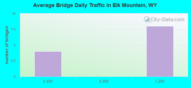
- 50,737Total average daily traffic
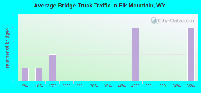
- 26,210Total average daily truck traffic
- National Bridge Inventory (NBI) Registered Bridges for Elk Mountain
- No street view available for this location

- New bridges - historical statistics
- 11940-1949
- 91960-1969
- 11970-1979
- 12010-2019
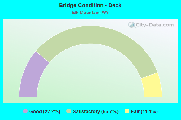
- Bridge Condition - Deck
- 22.2%Good
- 66.7%Satisfactory
- 11.1%Fair
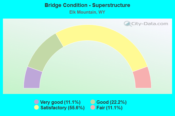
- Bridge Condition - Superstructure
- 11.1%Very good
- 22.2%Good
- 55.6%Satisfactory
- 11.1%Fair
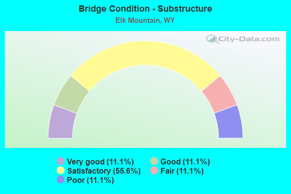
- Bridge Condition - Substructure
- 11.1%Very good
- 11.1%Good
- 55.6%Satisfactory
- 11.1%Fair
- 11.1%Poor
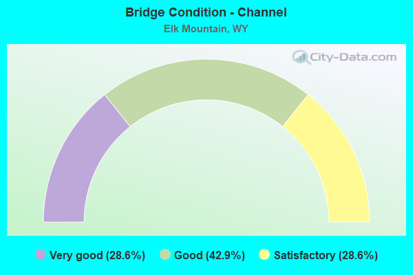
- Bridge Condition - Channel
- 28.6%Very good
- 42.9%Good
- 28.6%Satisfactory
Find on map >> Show street view
Structure Number: AVC, Location: Walcott Jct - Laramie (Lat: 41.704247, Lng: -106.403139), Route carried "on" structure: Interstate 80, Year Built: 1968, Status: Open, Structure Length: 4.82m (15.81ft), Average Daily Traffic: 6,030 (year 2021), Truck Traffic: 61%, Average Future Daily Traffic: 8,442 (year 2041), Design Load: HS 20+Mod, Features Intersected: Medicine Bow River
Minimum Vertical Clearance: 30+ m (98+ ft), Kilometerpoint: 416.469, Lanes on structure: 2, Base Highway Network: Yes (Inventory Route: ML8, Subroute: 2), Owner: State Highway Agency, Approaching Roadway Width: 11.6m (38.1ft), Skew: 11 degrees, Material/Design: Steel continuous, Design/Construction: Stringer/Multi-beam, Number Of Spans In Main Unit: 2, Length of Maximum Span: 23.5m (77.1ft), Curb-To-Curb Width: 11.6m (38.1ft), Out-to-Out Width: 12.4m (40.7ft)
Condition: Deck: Satisfactory, Superstructure: Satisfactory, Substructure: Satisfactory, Channel: Good, Operating Rating: 50.8 metric tons, Method Used To Determine Operating Rating: Load Factor (LF), Inventory Rating: 29.9 metric tons, Method Used To Determine Inventory Rating: Load Factor (LF), Structural Evaluation: Equal to present minimum criteria, Deck Geometry: Equal to present minimum criteria, Waterway Adequacy: Equal to present desirable criteria, Approach Roadway Alignment: Equal to present desirable criteria, Designated Inspection Frequency: Every 24 months, Inspection Date: May 2021, Deck Structure Type: Concrete Cast-file-Place, Wearing Surface/Protective System: Wearing Surface: Latex Concrete, Membrane: Preformed Fabric
Find on map >> Show street view
Structure Number: AVD, Location: Walcott Jct - Laramie (Lat: 41.704578, Lng: -106.402744), Route carried "on" structure: Interstate 80, Year Built: 1968, Status: Open, Structure Length: 4.82m (15.81ft), Average Daily Traffic: 6,500 (year 2021), Truck Traffic: 44%, Average Future Daily Traffic: 9,100 (year 2041), Design Load: HS 20+Mod, Features Intersected: Medicine Bow River
Minimum Vertical Clearance: 30+ m (98+ ft), Kilometerpoint: 416.250, Lanes on structure: 2, Base Highway Network: Yes (Inventory Route: ML8, Subroute: 2), Owner: State Highway Agency, Approaching Roadway Width: 11.6m (38.1ft), Skew: 11 degrees, Material/Design: Steel continuous, Design/Construction: Stringer/Multi-beam, Number Of Spans In Main Unit: 2, Length of Maximum Span: 23.5m (77.1ft), Curb-To-Curb Width: 11.6m (38.1ft), Out-to-Out Width: 12.4m (40.7ft)
Condition: Deck: Satisfactory, Superstructure: Satisfactory, Substructure: Satisfactory, Channel: Very good, Operating Rating: 50.8 metric tons, Method Used To Determine Operating Rating: Load Factor (LF), Inventory Rating: 29.9 metric tons, Method Used To Determine Inventory Rating: Load Factor (LF), Structural Evaluation: Equal to present minimum criteria, Deck Geometry: Equal to present minimum criteria, Waterway Adequacy: Equal to present desirable criteria, Approach Roadway Alignment: Equal to present desirable criteria, Designated Inspection Frequency: Every 24 months, Inspection Date: May 2021, Deck Structure Type: Concrete Cast-file-Place, Wearing Surface/Protective System: Wearing Surface: Epoxy Overlay, Membrane: Preformed Fabric
Find on map >> Show street view
Structure Number: AVE, Location: Walcott Jct - Laramie (Lat: 41.700583, Lng: -106.392903), Route carried "on" structure: Interstate 80, Year Built: 1969, Status: Open, Structure Length: 5.12m (16.80ft), Average Daily Traffic: 6,030 (year 2021), Truck Traffic: 61%, Average Future Daily Traffic: 8,442 (year 2041), Design Load: HS 20+Mod, Features Intersected: E F Medicine Bow River
Minimum Vertical Clearance: 30+ m (98+ ft), Kilometerpoint: 417.412, Lanes on structure: 2, Base Highway Network: Yes (Inventory Route: ML8, Subroute: 2), Owner: State Highway Agency, Approaching Roadway Width: 12.2m (40.0ft), Skew: 11 degrees, Material/Design: Steel continuous, Design/Construction: Stringer/Multi-beam, Number Of Spans In Main Unit: 3, Length of Maximum Span: 20.1m (65.9ft), Curb-To-Curb Width: 12.2m (40.0ft), Out-to-Out Width: 13.0m (42.7ft)
Condition: Deck: Good, Superstructure: Satisfactory, Substructure: Good, Channel: Good, Operating Rating: 52.6 metric tons, Method Used To Determine Operating Rating: Load Factor (LF), Inventory Rating: 30.8 metric tons, Method Used To Determine Inventory Rating: Load Factor (LF), Structural Evaluation: Equal to present minimum criteria, Deck Geometry: Better than present minimum criteria, Waterway Adequacy: Equal to present desirable criteria, Approach Roadway Alignment: Equal to present desirable criteria, Designated Inspection Frequency: Every 24 months, Inspection Date: June 2020, Deck Structure Type: Concrete Cast-file-Place, Wearing Surface/Protective System: Wearing Surface: Latex Concrete, Membrane: Preformed Fabric
Find on map >> Show street view
Structure Number: AVF, Location: Walcott Jct - Laramie (Lat: 41.700897, Lng: -106.392497), Route carried "on" structure: Interstate 80, Year Built: 1969, Status: Open, Structure Length: 5.12m (16.80ft), Average Daily Traffic: 6,500 (year 2021), Truck Traffic: 44%, Average Future Daily Traffic: 9,100 (year 2041), Design Load: HS 20+Mod, Features Intersected: E F Medicine Bow River
Minimum Vertical Clearance: 30+ m (98+ ft), Kilometerpoint: 417.197, Lanes on structure: 2, Base Highway Network: Yes (Inventory Route: ML8, Subroute: 2), Owner: State Highway Agency, Approaching Roadway Width: 11.6m (38.1ft), Skew: 11 degrees, Material/Design: Steel continuous, Design/Construction: Stringer/Multi-beam, Number Of Spans In Main Unit: 3, Length of Maximum Span: 20.1m (65.9ft), Curb-To-Curb Width: 12.2m (40.0ft), Out-to-Out Width: 13.0m (42.7ft)
Condition: Deck: Satisfactory, Superstructure: Fair, Substructure: Fair, Channel: Good, Operating Rating: 52.6 metric tons, Method Used To Determine Operating Rating: Load Factor (LF), Inventory Rating: 30.8 metric tons, Method Used To Determine Inventory Rating: Load Factor (LF), Structural Evaluation: Somewhat better than minimum adequacy, Deck Geometry: Better than present minimum criteria, Waterway Adequacy: Equal to present desirable criteria, Approach Roadway Alignment: Equal to present desirable criteria, Designated Inspection Frequency: Every 24 months, Inspection Date: June 2020, Deck Structure Type: Concrete Cast-file-Place, Wearing Surface/Protective System: Wearing Surface: Latex Concrete, Membrane: Preformed Fabric
Find on map >> Show street view
Structure Number: AVG, Location: Walcott Jct - Laramie (Lat: 41.693175, Lng: -106.384356), Route carried "on" structure: Interstate 80, Year Built: 1969, Status: Open, Structure Length: 4.72m (15.49ft), Average Daily Traffic: 6,030 (year 2021), Truck Traffic: 61%, Average Future Daily Traffic: 8,442 (year 2041), Design Load: HS 20+Mod, Features Intersected: CR 3/Elk Mtn-Med Bow Rd
Minimum Vertical Clearance: 30+ m (98+ ft), Kilometerpoint: 418.528, Lanes on structure: 2, Lanes under structure: 2, Base Highway Network: Yes (Inventory Route: ML8, Subroute: 2), Owner: State Highway Agency, Approaching Roadway Width: 10.7m (35.1ft), Skew: 12 degrees, Material/Design: Concrete continuous, Design/Construction: Tee Beam, Number Of Spans In Main Unit: 3, Length of Maximum Span: 18.9m (62.0ft), Curb-To-Curb Width: 12.2m (40.0ft), Out-to-Out Width: 13.0m (42.7ft)
Condition: Deck: Satisfactory, Superstructure: Good, Substructure: Satisfactory, Operating Rating: 53.5 metric tons, Method Used To Determine Operating Rating: Load Factor (LF), Inventory Rating: 31.8 metric tons, Method Used To Determine Inventory Rating: Load Factor (LF), Structural Evaluation: Equal to present minimum criteria, Deck Geometry: Better than present minimum criteria, Underclear: Better than present minimum criteria, Approach Roadway Alignment: Equal to present desirable criteria, Designated Inspection Frequency: Every 24 months, Inspection Date: June 2020, Deck Structure Type: Concrete Cast-file-Place, Wearing Surface/Protective System: Wearing Surface: Latex Concrete, Membrane: Preformed Fabric
Find on map >> Show street view
Structure Number: AVH, Location: Walcott Jct - Laramie (Lat: 41.693508, Lng: -106.383928), Route carried "on" structure: Interstate 80, Year Built: 1969, Status: Open, Structure Length: 4.72m (15.49ft), Average Daily Traffic: 6,500 (year 2021), Truck Traffic: 44%, Average Future Daily Traffic: 9,100 (year 2041), Design Load: HS 20+Mod, Features Intersected: CR 3/Elk Mtn-Med Bow Rd
Minimum Vertical Clearance: 30+ m (98+ ft), Kilometerpoint: 418.310, Lanes on structure: 2, Lanes under structure: 2, Base Highway Network: Yes (Inventory Route: ML8, Subroute: 2), Owner: State Highway Agency, Approaching Roadway Width: 10.7m (35.1ft), Skew: 12 degrees, Material/Design: Concrete continuous, Design/Construction: Tee Beam, Number Of Spans In Main Unit: 3, Length of Maximum Span: 18.9m (62.0ft), Curb-To-Curb Width: 12.2m (40.0ft), Out-to-Out Width: 13.0m (42.7ft)
Condition: Deck: Satisfactory, Superstructure: Good, Substructure: Satisfactory, Operating Rating: 53.5 metric tons, Method Used To Determine Operating Rating: Load Factor (LF), Inventory Rating: 31.8 metric tons, Method Used To Determine Inventory Rating: Load Factor (LF), Structural Evaluation: Equal to present minimum criteria, Deck Geometry: Better than present minimum criteria, Underclear: Better than present minimum criteria, Approach Roadway Alignment: Equal to present desirable criteria, Designated Inspection Frequency: Every 24 months, Inspection Date: June 2020, Deck Structure Type: Concrete Cast-file-Place, Wearing Surface/Protective System: Wearing Surface: Bituminous, Membrane: Preformed Fabric
Find on map >> Show street view
Structure Number: CMI, Location: Jct Us 30 - Elk Mountain (Lat: 41.724631, Lng: -106.459750), Route carried "on" structure: State highway 72, Year Built: 1968, Status: Open, Structure Length: 10.03m (32.91ft), Average Daily Traffic: 171 (year 2021), Truck Traffic: 9%, Average Future Daily Traffic: 239 (year 2041), Design Load: HS 20, Features Intersected: I-80
Minimum Vertical Clearance: 30+ m (98+ ft), Kilometerpoint: 19.768, Lanes on structure: 2, Lanes under structure: 4, Owner: State Highway Agency, Approaching Roadway Width: 9.8m (32.2ft), Skew: 2 degrees, Material/Design: Steel continuous, Design/Construction: Stringer/Multi-beam, Number Of Spans In Main Unit: 3, Length of Maximum Span: 32.9m (107.9ft), Curb-To-Curb Width: 9.8m (32.2ft), Out-to-Out Width: 10.6m (34.8ft)
Condition: Deck: Satisfactory, Superstructure: Satisfactory, Substructure: Satisfactory, Operating Rating: 61.7 metric tons, Method Used To Determine Operating Rating: Load Factor (LF), Inventory Rating: 36.3 metric tons, Method Used To Determine Inventory Rating: Load Factor (LF), Structural Evaluation: Equal to present minimum criteria, Deck Geometry: Better than present minimum criteria, Underclear: Equal to present minimum criteria, Approach Roadway Alignment: Equal to present desirable criteria, Designated Inspection Frequency: Every 24 months, Inspection Date: June 2020, Deck Structure Type: Concrete Cast-file-Place, Wearing Surface/Protective System: Wearing Surface: Latex Concrete
Find on map >> Show street view
Structure Number: DDI, Location: Jct Us 30- Elk Mountain (Lat: 41.688856, Lng: -106.416200), Route carried "on" structure: State highway 72, Year Built: 1975, Status: Open, Structure Length: 0.63m (2.07ft), Average Daily Traffic: 357 (year 2021), Truck Traffic: 10%, Average Future Daily Traffic: 500 (year 2041), Design Load: HS 20, Features Intersected: Slough Creek
Minimum Vertical Clearance: 30+ m (98+ ft), Kilometerpoint: 25.413, Lanes on structure: 2, Owner: State Highway Agency, Approaching Roadway Width: 9.1m (29.9ft), Material/Design: Concrete continuous, Design/Construction: Culvert, Number Of Spans In Main Unit: 2, Length of Maximum Span: 3.0m (9.8ft)
Condition: Channel: Satisfactory, Culverts: Good, Operating Rating: 32.7 metric tons, Method Used To Determine Operating Rating: Field evaluation and documented engineering judgment, Inventory Rating: 32.7 metric tons, Method Used To Determine Inventory Rating: Field evaluation and documented engineering judgment, Structural Evaluation: Better than present minimum criteria, Waterway Adequacy: Equal to present desirable criteria, Approach Roadway Alignment: Equal to present desirable criteria, Designated Inspection Frequency: Every 24 months, Inspection Date: June 2020
Find on map >> Show street view
Structure Number: MIJ, Location: 3 Mi Nw Of Elk Mountain (Lat: 41.706122, Lng: -106.431347), Route carried "on" structure: County highway 109, Year Built: 1940, Status: Posted for load, Structure Length: 1.09m (3.58ft), Average Daily Traffic: 9 (year 2021), Truck Traffic: 3%, Average Future Daily Traffic: 13 (year 2041), Features Intersected: Mill Creek
Minimum Vertical Clearance: 30+ m (98+ ft), Kilometerpoint: 0.703, Lanes on structure: 1, Owner: County Highway Agency, Approaching Roadway Width: 4.9m (16.1ft), Material/Design: Steel, Design/Construction: Girder and Floorbeam System, Number Of Spans In Main Unit: 1, Length of Maximum Span: 10.1m (33.1ft), Curb-To-Curb Width: 4.9m (16.1ft), Out-to-Out Width: 4.9m (16.1ft)
Condition: Deck: Fair, Superstructure: Satisfactory, Substructure: Poor, Channel: Satisfactory, Operating Rating: 11.4 metric tons, Method Used To Determine Operating Rating: Load Factor (LF), Inventory Rating: 6.9 metric tons, Method Used To Determine Inventory Rating: Load Factor (LF), Structural Evaluation: High priority of replacement, Deck Geometry: High priority of corrective action, Waterway Adequacy: Somewhat better than minimum adequacy, Approach Roadway Alignment: Equal to present minimum criteria, Bridge Posting: Required (Relationship of Operating Rating to Maximum Legal Load: 30.0 - 39.9% below), Designated Inspection Frequency: Every 12 months, Critical Feature Inspection Frequency: Every 24 months, Inspection Date: August 2021, Critical Feature Inspection Date: August 2021, Bridge Improvement Cost: $130,000, Roadway Improvement Cost: $13,000, Total Project Cost: $195,000, Deck Structure Type: Wood or Timber, Wearing Surface/Protective System: Wearing Surface: Wood or Timber
Find on map >> Show street view
Structure Number: MVZ, Location: Elk Mountain-E Main St (Lat: 41.686883, Lng: -106.413203), Route carried "on" structure: County highway 3, Year Built: 2016, Status: Open, Structure Length: 2.59m (8.50ft), Average Daily Traffic: 80 (year 2021), Truck Traffic: 10%, Average Future Daily Traffic: 112 (year 2041), Design Load: HL 93, Features Intersected: Medicine Bow River
Minimum Vertical Clearance: 30+ m (98+ ft), Kilometerpoint: 0.013, Lanes on structure: 2, Owner: County Highway Agency, Approaching Roadway Width: 5.5m (18.0ft), Material/Design: Steel, Design/Construction: Stringer/Multi-beam, Number Of Spans In Main Unit: 1, Length of Maximum Span: 25.0m (82.0ft), Curb-To-Curb Width: 7.9m (25.9ft), Out-to-Out Width: 9.8m (32.2ft)
Condition: Deck: Good, Superstructure: Very good, Substructure: Very good, Channel: Very good, Operating Rating: 45.4 metric tons, Method Used To Determine Operating Rating: Load and Resistance Factor Rating (LRFR) rating reported by rating factor(RF) method using HL-93 loadings, Inventory Rating: 35.0 metric tons, Method Used To Determine Inventory Rating: Load and Resistance Factor Rating (LRFR) rating reported by rating factor(RF) method using HL-93 loadings, Structural Evaluation: Equal to present desirable criteria, Deck Geometry: Equal to present minimum criteria, Waterway Adequacy: Better than present minimum criteria, Approach Roadway Alignment: Equal to present minimum criteria, Designated Inspection Frequency: Every 24 months, Inspection Date: September 2020, Deck Structure Type: Concrete Cast-file-Place, Wearing Surface/Protective System: Deck Protection: Epoxy Coated Reinforcing
Find on map >> Show street view
Structure Number: CMI, Location: Jct Us 30 - Elk Mountain (Lat: 41.724631, Lng: -106.459750), Route carried "under" structure: Interstate 80, Year Built: 1968, Structure Length: 0. m, Average Daily Traffic: 6,030 (year 2021), Truck Traffic: 61%, Features Intersected: I-80, Facility Carried by Structure: WYO 72
Minimum Vertical Clearance: 5.46m (17.91ft), Kilometerpoint: 411.086, Lanes on structure: 2, Lanes under structure: 2, Material/Design: Steel continuous, Design/Construction: Stringer/Multi-beam, Length of Maximum Span: 32.9m (107.9ft)
Find on map >> Show street view
Structure Number: CMI, Location: Jct Us 30 - Elk Mountain (Lat: 41.724631, Lng: -106.459750), Route carried "under" structure: Interstate 80, Year Built: 1968, Structure Length: 0. m, Average Daily Traffic: 6,500 (year 2021), Truck Traffic: 44%, Features Intersected: I-80, Facility Carried by Structure: WYO 72
Minimum Vertical Clearance: 5.49m (18.01ft), Kilometerpoint: 410.854, Lanes on structure: 2, Lanes under structure: 2, Material/Design: Steel continuous, Design/Construction: Stringer/Multi-beam, Length of Maximum Span: 32.9m (107.9ft)