Bridge Statistics for Ellenburg, New York (NY)
Condition, Traffic, Stress, Structural Evaluation, Project Costs
- National Bridge Inventory (NBI) Statistics
- 12Number of bridges
- 66ft / 20.0mTotal length
- $8,839,000Total costs
- 12,396Total average daily traffic
- 1,503Total average daily truck traffic
- 13,521Total future (year 2035) average daily traffic
- National Bridge Inventory (NBI) Registered Bridges for Ellenburg
- No street view available for this location
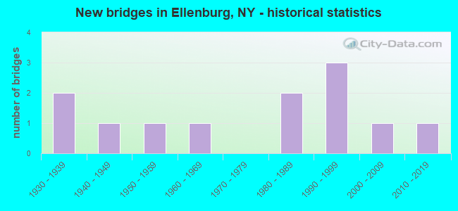
- New bridges - historical statistics
- 21930-1939
- 11940-1949
- 11950-1959
- 11960-1969
- 21980-1989
- 31990-1999
- 12000-2009
- 12010-2019

- Reconstructed bridges - Historical Statistics
- 21990-1999
- 12000-2009


- Bridge Condition - Deck
- 20.0%Very good
- 30.0%Good
- 20.0%Satisfactory
- 20.0%Fair
- 10.0%Poor

- Bridge Condition - Superstructure
- 9.1%Excellent
- 54.5%Very good
- 18.2%Good
- 18.2%Fair

- Bridge Condition - Substructure
- 45.5%Very good
- 18.2%Good
- 27.3%Satisfactory
- 9.1%Fair

- Bridge Condition - Channel
- 8.3%Excellent
- 25.0%Very good
- 50.0%Good
- 8.3%Fair
- 8.3%Poor
Find on map >> Show street view
Structure Number: 100901, Location: 2.5 MI NE JCT RTS 11+ 190 (Lat: 44.906294, Lng: -73.795069), Route carried "on" structure: US 11, Year Built: 1948, Status: Open, Structure Length: 1.58m (5.18ft), Average Daily Traffic: 2,452 (year 2018), Truck Traffic: 18%, Average Future Daily Traffic: 2,475 (year 2040), Design Load: HS 20, Features Intersected: GREAT CHAZY RIVER
Minimum Vertical Clearance: 30+ m (98+ ft), Kilometerpoint: 19.485, Lanes on structure: 2, Base Highway Network: Yes, Owner: State Highway Agency, Approaching Roadway Width: 11.6m (38.1ft), Material/Design: Concrete, Design/Construction: Frame, Number Of Spans In Main Unit: 1, Length of Maximum Span: 13.7m (44.9ft), Curb or Sidewalk Widths: Left: 1.5m (4.9ft), Right: 0.0m, Curb-To-Curb Width: 11.8m (38.7ft), Out-to-Out Width: 14.1m (46.3ft)
Condition: Deck: Poor, Superstructure: Fair, Substructure: Satisfactory, Channel: Good, Operating Rating: 51.7 metric tons, Method Used To Determine Operating Rating: Load Factor (LF), Inventory Rating: 30.8 metric tons, Method Used To Determine Inventory Rating: Load Factor (LF), Structural Evaluation: Somewhat better than minimum adequacy, Deck Geometry: Somewhat better than minimum adequacy, Waterway Adequacy: Somewhat better than minimum adequacy, Approach Roadway Alignment: Equal to present desirable criteria, Length Of Structure Improvement: 1.58m (5.18ft), Designated Inspection Frequency: Every 24 months, Inspection Date: July 2021, Bridge Improvement Cost: $916,000, Roadway Improvement Cost: $536,000, Total Project Cost: $1,452,000 ( Estimate for 2021)
Find on map >> Show street view
Structure Number: 103963, Location: HAMLET OF ELLENBURG CTR (Lat: 44.865153, Lng: -73.893992), Route carried "on" structure: County highway , Year Built: 1937, Status: Open, Structure Length: 0.85m (2.79ft), Average Daily Traffic: 433 (year 2020), Truck Traffic: 4%, Average Future Daily Traffic: 606 (year 2040), Features Intersected: N BR GT CHAZY RIV, Facility Carried by Structure: CR5 OLD NYS 190
Minimum Vertical Clearance: 30+ m (98+ ft), Kilometerpoint: 9.268, Lanes on structure: 2, Owner: County Highway Agency, Approaching Roadway Width: 11.6m (38.1ft), Skew: 3 degrees, Material/Design: Concrete continuous, Design/Construction: Culvert, Number Of Spans In Main Unit: 2, Length of Maximum Span: 3.7m (12.1ft)
Condition: Channel: Poor, Culverts: Satisfactory, Structural Evaluation: Equal to present minimum criteria, Waterway Adequacy: Meets minimum limits, Approach Roadway Alignment: Somewhat better than minimum adequacy, Length Of Structure Improvement: 0.85m (2.79ft), Designated Inspection Frequency: Every 24 months, Inspection Date: July 2020, Bridge Improvement Cost: $198,000, Roadway Improvement Cost: $116,000, Total Project Cost: $314,000 ( Estimate for 2021), Wearing Surface/Protective System: Wearing Surface: Bituminous
Find on map >> Show street view
Structure Number: 103964, Location: .5 MI SE JCT SH 190 & US (Lat: 44.891592, Lng: -73.841206), Route carried "on" structure: State highway 971L, Year Built: 1988, Status: Open, Structure Length: 2.04m (6.69ft), Average Daily Traffic: 3,013 (year 2020), Truck Traffic: 12%, Average Future Daily Traffic: 3,041 (year 2040), Design Load: HS 20, Features Intersected: N B GRT CHAZY RVR
Minimum Vertical Clearance: 30+ m (98+ ft), Kilometerpoint: 0.016, Lanes on structure: 2, Base Highway Network: Yes, Owner: State Highway Agency, Approaching Roadway Width: 10.4m (34.1ft), Material/Design: Prestressed concrete, Design/Construction: Stringer/Multi-beam, Number Of Spans In Main Unit: 1, Length of Maximum Span: 18.8m (61.7ft), Curb or Sidewalk Widths: Left: 0.0m, Right: 1.8m (5.9ft), Curb-To-Curb Width: 10.4m (34.1ft), Out-to-Out Width: 13.2m (43.3ft)
Condition: Deck: Fair, Superstructure: Fair, Substructure: Good, Channel: Very good, Operating Rating: 60.8 metric tons, Method Used To Determine Operating Rating: Load Factor (LF), Inventory Rating: 24.5 metric tons, Method Used To Determine Inventory Rating: Load Factor (LF), Structural Evaluation: Somewhat better than minimum adequacy, Deck Geometry: Somewhat better than minimum adequacy, Waterway Adequacy: Equal to present desirable criteria, Approach Roadway Alignment: Equal to present desirable criteria, Length Of Structure Improvement: 2.04m (6.69ft), Designated Inspection Frequency: Every 24 months, Inspection Date: November 2020, Bridge Improvement Cost: $599,000, Roadway Improvement Cost: $351,000, Total Project Cost: $950,000 ( Estimate for 2021), Deck Structure Type: Concrete Cast-file-Place, Wearing Surface/Protective System: Wearing Surface: Bituminous, Membrane: Other, Deck Protection: Epoxy Coated Reinforcing
Find on map >> Show street view
Structure Number: 333639, Location: 1.5 MI N OF LEDGER CORNER (Lat: 44.782681, Lng: -73.766225), Route carried "on" structure: County highway , Year Built: 1966, Year Reconstructed: 1998, Status: Open, Structure Length: 1.22m (4.00ft), Average Daily Traffic: 605 (year 2015), Truck Traffic: 5%, Average Future Daily Traffic: 847 (year 2035), Design Load: HS 25 or greater, Features Intersected: GREAT CHAZY RIVER, Facility Carried by Structure: PLANK ROAD
Minimum Vertical Clearance: 30+ m (98+ ft), Kilometerpoint: 2.446, Lanes on structure: 2, Owner: County Highway Agency, Approaching Roadway Width: 9.1m (29.9ft), Skew: 2 degrees, Material/Design: Prestressed concrete, Design/Construction: Box Beam or Girders - Multiple, Number Of Spans In Main Unit: 1, Length of Maximum Span: 10.9m (35.8ft), Curb-To-Curb Width: 9.1m (29.9ft), Out-to-Out Width: 9.8m (32.2ft)
Condition: Deck: Fair, Superstructure: Very good, Substructure: Satisfactory, Channel: Very good, Operating Rating: 88.0 metric tons, Method Used To Determine Operating Rating: Load Factor (LF), Inventory Rating: 52.6 metric tons, Method Used To Determine Inventory Rating: Load Factor (LF), Structural Evaluation: Equal to present minimum criteria, Deck Geometry: Equal to present minimum criteria, Waterway Adequacy: Somewhat better than minimum adequacy, Approach Roadway Alignment: Better than present minimum criteria, Length Of Structure Improvement: 1.21m (3.97ft), Designated Inspection Frequency: Every 24 months, Inspection Date: August 2020, Bridge Improvement Cost: $319,000, Roadway Improvement Cost: $187,000, Total Project Cost: $505,000 ( Estimate for 2021), Deck Structure Type: Concrete Cast-file-Place, Wearing Surface/Protective System: Wearing Surface: Integral Concrete, Deck Protection: Epoxy Coated Reinforcing
Find on map >> Show street view
Structure Number: 333653, Location: 0.9 MI N ELLENBURG DEPOT (Lat: 44.918739, Lng: -73.795369), Route carried "on" structure: County highway , Year Built: 1996, Status: Open, Structure Length: 1.16m (3.81ft), Average Daily Traffic: 313 (year 2018), Truck Traffic: 10%, Average Future Daily Traffic: 438 (year 2038), Design Load: HS 25 or greater, Features Intersected: BRANDY BROOK, Facility Carried by Structure: COUNTY ROAD 8
Minimum Vertical Clearance: 30+ m (98+ ft), Kilometerpoint: 17.860, Lanes on structure: 2, Owner: County Highway Agency, Approaching Roadway Width: 7.3m (24.0ft), Material/Design: Prestressed concrete, Design/Construction: Box Beam or Girders - Multiple, Number Of Spans In Main Unit: 1, Length of Maximum Span: 10.3m (33.8ft), Curb-To-Curb Width: 7.3m (24.0ft), Out-to-Out Width: 7.9m (25.9ft)
Condition: Deck: Good, Superstructure: Very good, Substructure: Very good, Channel: Very good, Operating Rating: 72.6 metric tons, Method Used To Determine Operating Rating: Load Factor (LF), Inventory Rating: 43.5 metric tons, Method Used To Determine Inventory Rating: Load Factor (LF), Structural Evaluation: Equal to present desirable criteria, Deck Geometry: Somewhat better than minimum adequacy, Waterway Adequacy: Somewhat better than minimum adequacy, Approach Roadway Alignment: Equal to present desirable criteria, Length Of Structure Improvement: 1.15m (3.77ft), Designated Inspection Frequency: Every 24 months, Inspection Date: October 2020, Bridge Improvement Cost: $157,000, Roadway Improvement Cost: $92,000, Total Project Cost: $249,000 ( Estimate for 2021), Deck Structure Type: Concrete Cast-file-Place, Wearing Surface/Protective System: Wearing Surface: Monolithic Concrete, Deck Protection: Epoxy Coated Reinforcing
Find on map >> Show street view
Structure Number: 333659, Location: .5MI W ELLENBURG DEPOT (Lat: 44.905181, Lng: -73.800558), Route carried "on" structure: Other road , Year Built: 1951, Year Reconstructed: 1995, Status: Open, Structure Length: 1.13m (3.71ft), Average Daily Traffic: 112 (year 2020), Truck Traffic: 7%, Average Future Daily Traffic: 157 (year 2040), Design Load: H 20, Features Intersected: NBR GREAT CHAZY R, Facility Carried by Structure: LAKE ROXANNE ROAD
Minimum Vertical Clearance: 30+ m (98+ ft), Kilometerpoint: 1.512, Lanes on structure: 2, Owner: County Highway Agency, Approaching Roadway Width: 7.3m (24.0ft), Material/Design: Steel, Design/Construction: Stringer/Multi-beam, Number Of Spans In Main Unit: 1, Length of Maximum Span: 10.6m (34.8ft), Curb-To-Curb Width: 9.1m (29.9ft), Out-to-Out Width: 9.8m (32.2ft)
Condition: Deck: Good, Superstructure: Very good, Substructure: Satisfactory, Channel: Good, Operating Rating: 52.6 metric tons, Method Used To Determine Operating Rating: Load Factor (LF), Inventory Rating: 30.8 metric tons, Method Used To Determine Inventory Rating: Load Factor (LF), Structural Evaluation: Equal to present minimum criteria, Deck Geometry: Equal to present minimum criteria, Waterway Adequacy: Somewhat better than minimum adequacy, Approach Roadway Alignment: Equal to present minimum criteria, Length Of Structure Improvement: 1.12m (3.67ft), Designated Inspection Frequency: Every 24 months, Inspection Date: June 2021, Bridge Improvement Cost: $335,000, Roadway Improvement Cost: $196,000, Total Project Cost: $531,000 ( Estimate for 2021), Deck Structure Type: Concrete Cast-file-Place, Wearing Surface/Protective System: Wearing Surface: Integral Concrete, Deck Protection: Epoxy Coated Reinforcing
Find on map >> Show street view
Structure Number: 33366, Location: 1.1 MI NE OF ELLENBURG (Lat: 44.899031, Lng: -73.820589), Route carried "on" structure: Other road , Year Built: 1997, Status: Open, Structure Length: 2.74m (8.99ft), Average Daily Traffic: 96 (year 2016), Truck Traffic: 7%, Average Future Daily Traffic: 134 (year 2036), Design Load: HS 25 or greater, Features Intersected: NBR GREAT CHAZY R, Facility Carried by Structure: COLD SPRINGS ROAD
Minimum Vertical Clearance: 30+ m (98+ ft), Kilometerpoint: 0.917, Lanes on structure: 2, Owner: County Highway Agency, Approaching Roadway Width: 7.3m (24.0ft), Skew: 3 degrees, Material/Design: Prestressed concrete, Design/Construction: Box Beam or Girders - Multiple, Number Of Spans In Main Unit: 1, Length of Maximum Span: 25.9m (85.0ft), Curb-To-Curb Width: 7.3m (24.0ft), Out-to-Out Width: 7.9m (25.9ft)
Condition: Deck: Satisfactory, Superstructure: Good, Substructure: Very good, Channel: Good, Operating Rating: 89.8 metric tons, Method Used To Determine Operating Rating: Load Factor (LF), Inventory Rating: 68.0 metric tons, Method Used To Determine Inventory Rating: Load Factor (LF), Structural Evaluation: Better than present minimum criteria, Deck Geometry: Equal to present minimum criteria, Waterway Adequacy: Equal to present minimum criteria, Approach Roadway Alignment: Equal to present desirable criteria, Length Of Structure Improvement: 2.74m (8.99ft), Designated Inspection Frequency: Every 24 months, Inspection Date: April 2021, Bridge Improvement Cost: $366,000, Roadway Improvement Cost: $215,000, Total Project Cost: $581,000 ( Estimate for 2021), Deck Structure Type: Concrete Cast-file-Place, Wearing Surface/Protective System: Wearing Surface: Integral Concrete, Deck Protection: Epoxy Coated Reinforcing
Find on map >> Show street view
Structure Number: 333662, Location: 1.7 MI W ELLENBURG (Lat: 44.884142, Lng: -73.873936), Route carried "on" structure: State highway 190, Year Built: 1995, Status: Open, Structure Length: 1.40m (4.59ft), Average Daily Traffic: 987 (year 2012), Truck Traffic: 14%, Average Future Daily Traffic: 1,029 (year 2040), Design Load: HS 25 or greater, Features Intersected: NBR GREAT CHAZY R
Minimum Vertical Clearance: 30+ m (98+ ft), Kilometerpoint: 10.507, Lanes on structure: 2, Base Highway Network: Yes, Owner: State Highway Agency, Approaching Roadway Width: 9.1m (29.9ft), Skew: 1 degrees, Material/Design: Steel, Design/Construction: Stringer/Multi-beam, Number Of Spans In Main Unit: 1, Length of Maximum Span: 12.8m (42.0ft), Curb-To-Curb Width: 9.1m (29.9ft), Out-to-Out Width: 9.8m (32.2ft)
Condition: Deck: Satisfactory, Superstructure: Very good, Substructure: Very good, Channel: Good, Operating Rating: 74.4 metric tons, Method Used To Determine Operating Rating: Load Factor (LF), Inventory Rating: 44.5 metric tons, Method Used To Determine Inventory Rating: Load Factor (LF), Structural Evaluation: Equal to present desirable criteria, Deck Geometry: Equal to present minimum criteria, Waterway Adequacy: Somewhat better than minimum adequacy, Approach Roadway Alignment: Equal to present desirable criteria, Length Of Structure Improvement: 1.40m (4.59ft), Designated Inspection Frequency: Every 24 months, Inspection Date: April 2021, Bridge Improvement Cost: $432,000, Roadway Improvement Cost: $253,000, Total Project Cost: $685,000 ( Estimate for 2021), Deck Structure Type: Concrete Cast-file-Place, Wearing Surface/Protective System: Wearing Surface: Integral Concrete, Deck Protection: Epoxy Coated Reinforcing
Find on map >> Show street view
Structure Number: 333663, Location: .1MI N ELLENBURG CENTER (Lat: 44.865428, Lng: -73.893464), Route carried "on" structure: County highway , Year Built: 1938, Year Reconstructed: 2005, Status: Open, Structure Length: 0.91m (2.99ft), Average Daily Traffic: 314 (year 2015), Truck Traffic: 2%, Average Future Daily Traffic: 440 (year 2035), Features Intersected: N BR GRT CHAZY RV, Facility Carried by Structure: BRANDY BROOK ROAD
Minimum Vertical Clearance: 30+ m (98+ ft), Kilometerpoint: 0.064, Lanes on structure: 2, Owner: County Highway Agency, Approaching Roadway Width: 6.7m (22.0ft), Material/Design: Prestressed concrete, Design/Construction: Box Beam or Girders - Multiple, Number Of Spans In Main Unit: 1, Length of Maximum Span: 7.9m (25.9ft), Curb or Sidewalk Widths: Left: 0.0m, Right: 1.5m (4.9ft), Curb-To-Curb Width: 6.8m (22.3ft), Out-to-Out Width: 9.4m (30.8ft)
Condition: Deck: Very good, Superstructure: Excellent, Substructure: Fair, Channel: Fair, Inventory Rating: 87.1 metric tons, Method Used To Determine Inventory Rating: Load Factor (LF), Structural Evaluation: Somewhat better than minimum adequacy, Deck Geometry: Meets minimum limits, Waterway Adequacy: Meets minimum limits, Approach Roadway Alignment: Equal to present desirable criteria, Length Of Structure Improvement: 0.91m (2.99ft), Designated Inspection Frequency: Every 24 months, Inspection Date: July 2020, Bridge Improvement Cost: $290,000, Roadway Improvement Cost: $170,000, Total Project Cost: $459,000 ( Estimate for 2021), Deck Structure Type: Concrete Cast-file-Place, Wearing Surface/Protective System: Wearing Surface: Integral Concrete, Deck Protection: Epoxy Coated Reinforcing
Find on map >> Show street view
Structure Number: 333664, Location: 0.1 MI SE JCT RTS 190& 11 (Lat: 44.891200, Lng: -73.840042), Route carried "on" structure: State highway 190, Year Built: 1988, Status: Open, Structure Length: 1.01m (3.31ft), Average Daily Traffic: 3,443 (year 2020), Truck Traffic: 12%, Average Future Daily Traffic: 3,475 (year 2040), Design Load: HS 20, Features Intersected: MALARK BROOK
Minimum Vertical Clearance: 30+ m (98+ ft), Kilometerpoint: 13.467, Lanes on structure: 2, Base Highway Network: Yes, Owner: State Highway Agency, Approaching Roadway Width: 10.4m (34.1ft), Material/Design: Prestressed concrete, Number Of Spans In Main Unit: 1, Length of Maximum Span: 8.5m (27.9ft), Curb or Sidewalk Widths: Left: 0.0m, Right: 1.8m (5.9ft), Curb-To-Curb Width: 10.4m (34.1ft), Out-to-Out Width: 13.1m (43.0ft)
Condition: Deck: Good, Superstructure: Very good, Substructure: Good, Channel: Good, Inventory Rating: 40.8 metric tons, Method Used To Determine Inventory Rating: Allowable Stress (AS), Structural Evaluation: Better than present minimum criteria, Deck Geometry: Somewhat better than minimum adequacy, Waterway Adequacy: Somewhat better than minimum adequacy, Approach Roadway Alignment: Equal to present desirable criteria, Length Of Structure Improvement: 1.00m (3.28ft), Designated Inspection Frequency: Every 24 months, Inspection Date: May 2021, Bridge Improvement Cost: $426,000, Roadway Improvement Cost: $249,000, Total Project Cost: $675,000 ( Estimate for 2021), Deck Structure Type: Concrete Cast-file-Place, Wearing Surface/Protective System: Wearing Surface: Bituminous, Membrane: Other
Find on map >> Show street view
Structure Number: 333665, Location: 1.6MI NW MERRILL (Lat: 44.779797, Lng: -73.983808), Route carried "on" structure: Other road , Year Built: 2013, Status: Open, Structure Length: 1.95m (6.40ft), Average Daily Traffic: 315 (year 2020), Truck Traffic: 7%, Average Future Daily Traffic: 441 (year 2040), Design Load: HL 93, Features Intersected: CHATEAUGAYNARROWS, Facility Carried by Structure: NARROWS ROAD
Minimum Vertical Clearance: 30+ m (98+ ft), Kilometerpoint: 0.129, Lanes on structure: 2, Owner: County Highway Agency, Approaching Roadway Width: 10.1m (33.1ft), Material/Design: Concrete, Design/Construction: Arch - Deck, Number Of Spans In Main Unit: 1, Length of Maximum Span: 18.3m (60.0ft), Curb-To-Curb Width: 10.0m (32.8ft), Out-to-Out Width: 11.0m (36.1ft)
Condition: Superstructure: Good, Substructure: Very good, Channel: Excellent, Operating Rating: 74.4 metric tons, Method Used To Determine Operating Rating: Load Factor (LF), Inventory Rating: 40.8 metric tons, Method Used To Determine Inventory Rating: Load Factor (LF), Structural Evaluation: Better than present minimum criteria, Deck Geometry: Better than present minimum criteria, Waterway Adequacy: Equal to present desirable criteria, Approach Roadway Alignment: Equal to present desirable criteria, Length Of Structure Improvement: 1.95m (6.40ft), Designated Inspection Frequency: Every 24 months, Inspection Date: May 2021, Bridge Improvement Cost: $895,000, Roadway Improvement Cost: $524,000, Total Project Cost: $1,418,000 ( Estimate for 2021)
Find on map >> Show street view
Structure Number: 337027, Location: .1Mi N Rt11 & EllenburgDe (Lat: 44.907878, Lng: -73.793214), Route carried "on" structure: ServiceCounty highway , Year Built: 2006, Status: Open, Structure Length: 4.05m (13.29ft), Average Daily Traffic: 313 (year 2018), Truck Traffic: 10%, Average Future Daily Traffic: 438 (year 2038), Design Load: HS 25 or greater, Features Intersected: N.Br G.Chazy Rive, Facility Carried by Structure: Canaan Rd
Minimum Vertical Clearance: 32.69m (107.25ft), Kilometerpoint: 16.557, Lanes on structure: 2, Owner: County Highway Agency, Approaching Roadway Width: 7.9m (25.9ft), Material/Design: Prestressed concrete, Design/Construction: Box Beam or Girders - Multiple, Number Of Spans In Main Unit: 2, Length of Maximum Span: 19.4m (63.6ft), Curb-To-Curb Width: 7.8m (25.6ft), Out-to-Out Width: 8.9m (29.2ft)
Condition: Deck: Very good, Superstructure: Very good, Substructure: Very good, Channel: Good, Operating Rating: 98.9 metric tons, Method Used To Determine Operating Rating: Load Factor (LF), Inventory Rating: 59.0 metric tons, Method Used To Determine Inventory Rating: Load Factor (LF), Structural Evaluation: Equal to present desirable criteria, Deck Geometry: Somewhat better than minimum adequacy, Waterway Adequacy: Equal to present desirable criteria, Approach Roadway Alignment: Equal to present desirable criteria, Length Of Structure Improvement: 4.05m (13.29ft), Designated Inspection Frequency: Every 24 months, Inspection Date: October 2020, Bridge Improvement Cost: $643,000, Roadway Improvement Cost: $377,000, Total Project Cost: $1,020,000 ( Estimate for 2021), Deck Structure Type: Concrete Cast-file-Place, Wearing Surface/Protective System: Wearing Surface: Integral Concrete, Deck Protection: Epoxy Coated Reinforcing