Bridge Statistics for Ellicott, New York (NY)
Condition, Traffic, Stress, Structural Evaluation, Project Costs
- National Bridge Inventory (NBI) Statistics
- 39Number of bridges
- 308ft / 93.9mTotal length
- $92,889,000Total costs
- 151,977Total average daily traffic
- 14,583Total average daily truck traffic
- National Bridge Inventory (NBI) Registered Bridges for Ellicott
- No street view available for this location
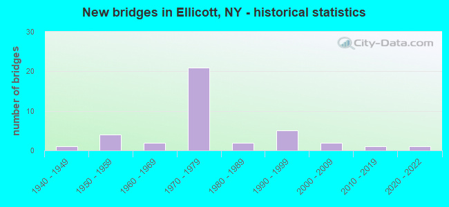
- New bridges - historical statistics
- 11940-1949
- 41950-1959
- 21960-1969
- 211970-1979
- 21980-1989
- 51990-1999
- 22000-2009
- 12010-2019
- 12020-2022
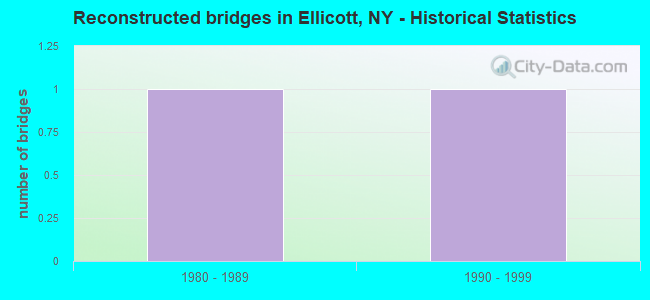
- Reconstructed bridges - Historical Statistics
- 11980-1989
- 11990-1999

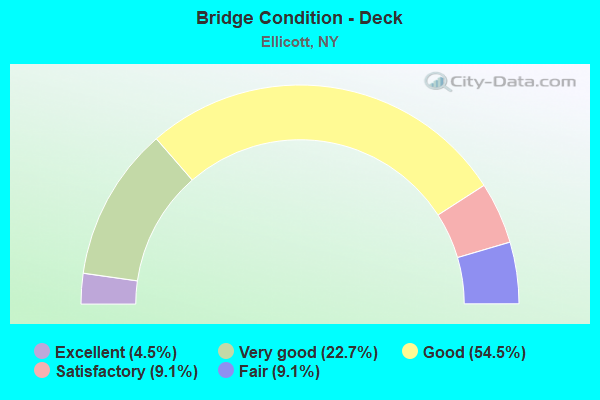
- Bridge Condition - Deck
- 4.5%Excellent
- 22.7%Very good
- 54.5%Good
- 9.1%Satisfactory
- 9.1%Fair
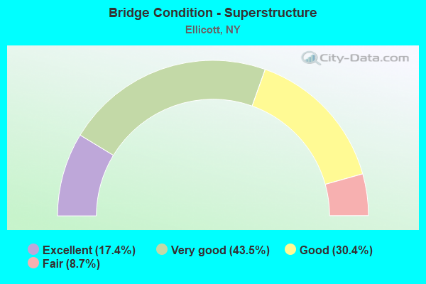
- Bridge Condition - Superstructure
- 17.4%Excellent
- 43.5%Very good
- 30.4%Good
- 8.7%Fair
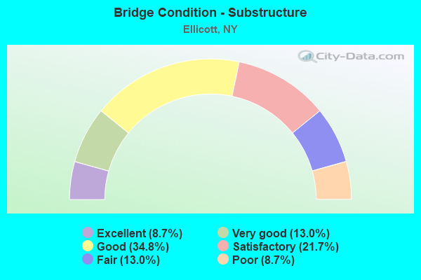
- Bridge Condition - Substructure
- 8.7%Excellent
- 13.0%Very good
- 34.8%Good
- 21.7%Satisfactory
- 13.0%Fair
- 8.7%Poor
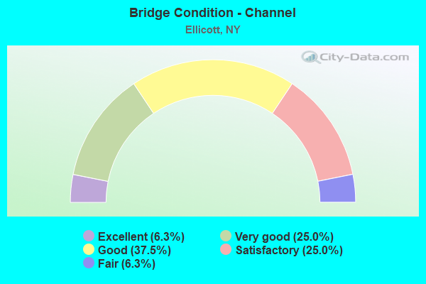
- Bridge Condition - Channel
- 6.3%Excellent
- 25.0%Very good
- 37.5%Good
- 25.0%Satisfactory
- 6.3%Fair
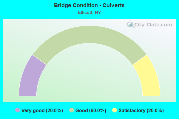
- Bridge Condition - Culverts
- 20.0%Very good
- 60.0%Good
- 20.0%Satisfactory
Find on map >> Show street view
Structure Number: 10121, Location: 1.0 MI EAST OF FLUVANNA (Lat: 42.120506, Lng: -79.270800), Route carried "on" structure: State highway 430, Year Built: 1993, Status: Open, Structure Length: 1.04m (3.41ft), Average Daily Traffic: 6,766 (year 2020), Truck Traffic: 6%, Average Future Daily Traffic: 7,144 (year 2040), Design Load: HS 25 or greater, Features Intersected: DRY BROOK
Minimum Vertical Clearance: 30+ m (98+ ft), Kilometerpoint: 59.211, Lanes on structure: 2, Base Highway Network: Yes, Owner: State Highway Agency, Approaching Roadway Width: 12.2m (40.0ft), Material/Design: Concrete, Design/Construction: Culvert, Number Of Spans In Main Unit: 2, Length of Maximum Span: 4.8m (15.7ft), Curb-To-Curb Width: 12.8m (42.0ft), Out-to-Out Width: 13.7m (44.9ft)
Condition: Channel: Satisfactory, Culverts: Good, Operating Rating: 76.0 metric tons, Method Used To Determine Operating Rating: Field evaluation and documented engineering judgment, Inventory Rating: 40.8 metric tons, Method Used To Determine Inventory Rating: Field evaluation and documented engineering judgment, Structural Evaluation: Better than present minimum criteria, Deck Geometry: Somewhat better than minimum adequacy, Waterway Adequacy: Meets minimum limits, Approach Roadway Alignment: Equal to present desirable criteria, Length Of Structure Improvement: 1.03m (3.38ft), Designated Inspection Frequency: Every 24 months, Inspection Date: June 2021, Bridge Improvement Cost: $393,000, Roadway Improvement Cost: $230,000, Total Project Cost: $623,000 ( Estimate for 2021), Wearing Surface/Protective System: Wearing Surface: Bituminous
Find on map >> Show street view
Structure Number: 101212, Location: 4.0 MI NE JCT RTS 394& 60 (Lat: 42.133092, Lng: -79.181883), Route carried "on" structure: State highway 394, Year Built: 1959, Status: Open, Structure Length: 5.06m (16.60ft), Average Daily Traffic: 5,264 (year 2020), Truck Traffic: 7%, Average Future Daily Traffic: 5,558 (year 2040), Features Intersected: CASSADAGA CREEK
Minimum Vertical Clearance: 30+ m (98+ ft), Kilometerpoint: 51.794, Lanes on structure: 2, Base Highway Network: Yes, Owner: State Highway Agency, Approaching Roadway Width: 17.7m (58.1ft), Skew: 22 degrees, Material/Design: Steel, Design/Construction: Stringer/Multi-beam, Number Of Spans In Main Unit: 2, Length of Maximum Span: 24.3m (79.7ft), Curb or Sidewalk Widths: Left: 1.6m (5.2ft), Right: 1.6m (5.2ft), Curb-To-Curb Width: 21.9m (71.9ft), Out-to-Out Width: 25.6m (84.0ft)
Condition: Deck: Fair, Superstructure: Fair, Substructure: Fair, Channel: Very good, Operating Rating: 65.4 metric tons, Method Used To Determine Operating Rating: Load and Resistance Factor Rating (LRFR) rating reported by rating factor(RF) method using HL-93 loadings, Inventory Rating: 50.2 metric tons, Method Used To Determine Inventory Rating: Load and Resistance Factor Rating (LRFR) rating reported by rating factor(RF) method using HL-93 loadings, Structural Evaluation: Somewhat better than minimum adequacy, Deck Geometry: Superior to present desirable criteria, Waterway Adequacy: Somewhat better than minimum adequacy, Approach Roadway Alignment: Equal to present desirable criteria, Length Of Structure Improvement: 5.05m (16.57ft), Designated Inspection Frequency: Every 24 months, Underwater Inspection Frequency: Every 60 months, Inspection Date: June 2021, Underwater Inspection Date: October 2019, Bridge Improvement Cost: $4,702,000, Roadway Improvement Cost: $2,753,000, Total Project Cost: $7,455,000 ( Estimate for 2021), Deck Structure Type: Concrete Cast-file-Place, Wearing Surface/Protective System: Wearing Surface: Bituminous
Find on map >> Show street view
Structure Number: 102778, Location: 0.8 MI N JCT RTS 60 + 17 (Lat: 42.133594, Lng: -79.241928), Route carried "on" structure: State highway 60, Year Built: 1946, Year Reconstructed: 1998, Status: Open, Structure Length: 1.16m (3.81ft), Average Daily Traffic: 6,536 (year 2018), Truck Traffic: 9%, Average Future Daily Traffic: 6,566 (year 2040), Design Load: HS 25 or greater, Features Intersected: MOON BROOK
Minimum Vertical Clearance: 30+ m (98+ ft), Kilometerpoint: 10.893, Lanes on structure: 2, Base Highway Network: Yes, Owner: State Highway Agency, Approaching Roadway Width: 12.2m (40.0ft), Skew: 4 degrees, Material/Design: Prestressed concrete, Design/Construction: Box Beam or Girders - Multiple, Number Of Spans In Main Unit: 1, Length of Maximum Span: 9.7m (31.8ft), Curb-To-Curb Width: 12.2m (40.0ft), Out-to-Out Width: 12.9m (42.3ft)
Condition: Deck: Excellent, Superstructure: Excellent, Substructure: Very good, Channel: Satisfactory, Operating Rating: 89.8 metric tons, Method Used To Determine Operating Rating: Load Factor (LF), Inventory Rating: 44.5 metric tons, Method Used To Determine Inventory Rating: Load Factor (LF), Structural Evaluation: Equal to present desirable criteria, Deck Geometry: Somewhat better than minimum adequacy, Waterway Adequacy: Somewhat better than minimum adequacy, Approach Roadway Alignment: Equal to present desirable criteria, Length Of Structure Improvement: 1.15m (3.77ft), Designated Inspection Frequency: Every 24 months, Inspection Date: August 2020, Bridge Improvement Cost: $699,000, Roadway Improvement Cost: $409,000, Total Project Cost: $1,108,000 ( Estimate for 2021), Wearing Surface/Protective System: Wearing Surface: Integral Concrete
Find on map >> Show street view
Structure Number: 102779, Location: 0.2 MI S JCT RTS 60 + 380 (Lat: 42.170753, Lng: -79.254681), Route carried "on" structure: State highway 60, Year Built: 1951, Year Reconstructed: 1992, Status: Open, Structure Length: 3.05m (10.01ft), Average Daily Traffic: 4,994 (year 2018), Truck Traffic: 10%, Average Future Daily Traffic: 5,017 (year 2040), Design Load: HS 20, Features Intersected: CR 81
Minimum Vertical Clearance: 30+ m (98+ ft), Kilometerpoint: 15.302, Lanes on structure: 2, Lanes under structure: 2, Base Highway Network: Yes, Owner: State Highway Agency, Approaching Roadway Width: 13.4m (44.0ft), Skew: 4 degrees, Material/Design: Steel, Design/Construction: Stringer/Multi-beam, Number Of Spans In Main Unit: 1, Length of Maximum Span: 28.9m (94.8ft), Curb-To-Curb Width: 12.2m (40.0ft), Out-to-Out Width: 13.2m (43.3ft)
Condition: Deck: Good, Superstructure: Very good, Substructure: Fair, Operating Rating: 74.4 metric tons, Method Used To Determine Operating Rating: Load Factor (LF), Inventory Rating: 44.5 metric tons, Method Used To Determine Inventory Rating: Load Factor (LF), Structural Evaluation: Somewhat better than minimum adequacy, Deck Geometry: Equal to present minimum criteria, Underclear: Meets minimum limits, Approach Roadway Alignment: Equal to present desirable criteria, Length Of Structure Improvement: 3.04m (9.97ft), Designated Inspection Frequency: Every 24 months, Inspection Date: May 2021, Bridge Improvement Cost: $3,377,000, Roadway Improvement Cost: $1,978,000, Total Project Cost: $5,355,000 ( Estimate for 2021), Deck Structure Type: Concrete Cast-file-Place, Wearing Surface/Protective System: Wearing Surface: Integral Concrete, Deck Protection: Epoxy Coated Reinforcing
Find on map >> Show street view
Structure Number: 10278, Location: 0.1 MI S JCT RTS 60 + 380 (Lat: 42.172692, Lng: -79.254933), Route carried "on" structure: State highway 60, Year Built: 2021, Status: Open, Structure Length: 1.10m (3.61ft), Average Daily Traffic: 4,994 (year 2018), Truck Traffic: 10%, Average Future Daily Traffic: 5,041 (year 2040), Features Intersected: BR CASSADAGA CRK
Minimum Vertical Clearance: 30+ m (98+ ft), Kilometerpoint: 15.527, Lanes on structure: 2, Base Highway Network: Yes, Owner: State Highway Agency, Approaching Roadway Width: 12.2m (40.0ft), Skew: 1 degrees, Material/Design: Concrete, Design/Construction: Frame, Number Of Spans In Main Unit: 1, Length of Maximum Span: 10.7m (35.1ft), Curb-To-Curb Width: 12.2m (40.0ft), Out-to-Out Width: 13.5m (44.3ft)
Condition: Superstructure: Excellent, Substructure: Excellent, Channel: Excellent, Operating Rating: 77.1 metric tons, Method Used To Determine Operating Rating: Load Factor (LF), Inventory Rating: 46.3 metric tons, Method Used To Determine Inventory Rating: Load Factor (LF), Structural Evaluation: Superior to present desirable criteria, Deck Geometry: Equal to present minimum criteria, Waterway Adequacy: Meets minimum limits, Approach Roadway Alignment: Equal to present desirable criteria, Length Of Structure Improvement: 1.00m (3.28ft), Designated Inspection Frequency: Every 24 months, Inspection Date: November 2021, Bridge Improvement Cost: $520,000, Roadway Improvement Cost: $305,000, Total Project Cost: $825,000 ( Estimate for 2021)
Find on map >> Show street view
Structure Number: 1062571, Location: 0.5 MI E FALCONER INT (Lat: 42.134544, Lng: -79.183242), Route carried "on" structure: Interstate 86, Year Built: 1969, Status: Open, Structure Length: 5.00m (16.40ft), Average Daily Traffic: 5,305 (year 2013), Truck Traffic: 19%, Design Load: HS 20, Features Intersected: CASSADAGA CREEK
Minimum Vertical Clearance: 30+ m (98+ ft), Kilometerpoint: 50.362, Lanes on structure: 2, Base Highway Network: Yes, Owner: State Highway Agency, Approaching Roadway Width: 11.6m (38.1ft), Material/Design: Steel, Design/Construction: Stringer/Multi-beam, Number Of Spans In Main Unit: 2, Length of Maximum Span: 24.0m (78.7ft), Curb-To-Curb Width: 12.5m (41.0ft), Out-to-Out Width: 13.4m (44.0ft)
Condition: Deck: Good, Superstructure: Very good, Substructure: Poor, Channel: Very good, Operating Rating: 62.6 metric tons, Method Used To Determine Operating Rating: Load Factor (LF), Inventory Rating: 35.4 metric tons, Method Used To Determine Inventory Rating: Load Factor (LF), Structural Evaluation: Meets minimum limits, Deck Geometry: Better than present minimum criteria, Waterway Adequacy: Equal to present minimum criteria, Approach Roadway Alignment: Better than present minimum criteria, Length Of Structure Improvement: 4.99m (16.37ft), Designated Inspection Frequency: Every 24 months, Underwater Inspection Frequency: Every 60 months, Inspection Date: May 2021, Underwater Inspection Date: August 2021, Bridge Improvement Cost: $2,867,000, Roadway Improvement Cost: $1,679,000, Total Project Cost: $4,546,000 ( Estimate for 2021), Deck Structure Type: Concrete Cast-file-Place, Wearing Surface/Protective System: Wearing Surface: Integral Concrete
Find on map >> Show street view
Structure Number: 1062572, Location: 0.5 MI E FALCONER INT (Lat: 42.134317, Lng: -79.182903), Route carried "on" structure: Interstate 86, Year Built: 1969, Status: Open, Structure Length: 5.00m (16.40ft), Average Daily Traffic: 3,943 (year 2018), Truck Traffic: 17%, Average Future Daily Traffic: 4,419 (year 2040), Design Load: HS 20, Features Intersected: CASSADAGA CREEK
Minimum Vertical Clearance: 30+ m (98+ ft), Kilometerpoint: 50.346, Lanes on structure: 2, Base Highway Network: Yes, Owner: State Highway Agency, Approaching Roadway Width: 11.6m (38.1ft), Material/Design: Steel, Design/Construction: Stringer/Multi-beam, Number Of Spans In Main Unit: 2, Length of Maximum Span: 24.0m (78.7ft), Curb-To-Curb Width: 12.6m (41.3ft), Out-to-Out Width: 13.4m (44.0ft)
Condition: Deck: Good, Superstructure: Very good, Substructure: Poor, Channel: Very good, Operating Rating: 62.6 metric tons, Method Used To Determine Operating Rating: Load Factor (LF), Inventory Rating: 35.4 metric tons, Method Used To Determine Inventory Rating: Load Factor (LF), Structural Evaluation: Meets minimum limits, Deck Geometry: Better than present minimum criteria, Waterway Adequacy: Equal to present minimum criteria, Approach Roadway Alignment: Better than present minimum criteria, Length Of Structure Improvement: 4.99m (16.37ft), Designated Inspection Frequency: Every 24 months, Critical Feature Inspection Frequency: Every 24 months, Underwater Inspection Frequency: Every 60 months, Inspection Date: May 2021, Critical Feature Inspection Date: May 2021, Underwater Inspection Date: August 2021, Bridge Improvement Cost: $2,867,000, Roadway Improvement Cost: $1,679,000, Total Project Cost: $4,546,000 ( Estimate for 2021), Deck Structure Type: Concrete Cast-file-Place, Wearing Surface/Protective System: Wearing Surface: Integral Concrete
Find on map >> Show street view
Structure Number: 1062581, Location: 0.6 MI E FALCONER INT (Lat: 42.136117, Lng: -79.180631), Route carried "on" structure: Interstate 86, Year Built: 1971, Status: Open, Structure Length: 3.63m (11.91ft), Average Daily Traffic: 5,305 (year 2013), Truck Traffic: 19%, Design Load: HS 20, Features Intersected: COUNTY ROAD 16
Minimum Vertical Clearance: 30+ m (98+ ft), Kilometerpoint: 50.651, Lanes on structure: 2, Lanes under structure: 2, Base Highway Network: Yes, Owner: State Highway Agency, Approaching Roadway Width: 11.6m (38.1ft), Skew: 1 degrees, Material/Design: Steel, Design/Construction: Stringer/Multi-beam, Number Of Spans In Main Unit: 1, Length of Maximum Span: 35.0m (114.8ft), Curb-To-Curb Width: 12.7m (41.7ft), Out-to-Out Width: 13.7m (44.9ft)
Condition: Deck: Good, Superstructure: Very good, Substructure: Satisfactory, Operating Rating: 68.9 metric tons, Method Used To Determine Operating Rating: Load Factor (LF), Inventory Rating: 36.3 metric tons, Method Used To Determine Inventory Rating: Load Factor (LF), Structural Evaluation: Equal to present minimum criteria, Deck Geometry: Better than present minimum criteria, Underclear: Equal to present minimum criteria, Approach Roadway Alignment: Equal to present minimum criteria, Length Of Structure Improvement: 3.62m (11.88ft), Designated Inspection Frequency: Every 24 months, Inspection Date: April 2021, Bridge Improvement Cost: $2,191,000, Roadway Improvement Cost: $1,283,000, Total Project Cost: $3,475,000 ( Estimate for 2021), Deck Structure Type: Concrete Cast-file-Place, Wearing Surface/Protective System: Wearing Surface: Monolithic Concrete
Find on map >> Show street view
Structure Number: 1062582, Location: 0.6 MI E FALCONER INT (Lat: 42.135864, Lng: -79.180319), Route carried "on" structure: Interstate 86, Year Built: 1971, Status: Open, Structure Length: 3.63m (11.91ft), Average Daily Traffic: 3,943 (year 2018), Truck Traffic: 17%, Average Future Daily Traffic: 4,419 (year 2040), Design Load: HS 20, Features Intersected: COUNTY ROAD 16
Minimum Vertical Clearance: 30+ m (98+ ft), Kilometerpoint: 50.635, Lanes on structure: 2, Lanes under structure: 2, Base Highway Network: Yes, Owner: State Highway Agency, Approaching Roadway Width: 11.6m (38.1ft), Skew: 1 degrees, Material/Design: Steel, Design/Construction: Stringer/Multi-beam, Number Of Spans In Main Unit: 1, Length of Maximum Span: 35.0m (114.8ft), Curb-To-Curb Width: 12.7m (41.7ft), Out-to-Out Width: 13.7m (44.9ft)
Condition: Deck: Good, Superstructure: Good, Substructure: Satisfactory, Operating Rating: 68.9 metric tons, Method Used To Determine Operating Rating: Load Factor (LF), Inventory Rating: 36.3 metric tons, Method Used To Determine Inventory Rating: Load Factor (LF), Structural Evaluation: Equal to present minimum criteria, Deck Geometry: Better than present minimum criteria, Underclear: Equal to present minimum criteria, Approach Roadway Alignment: Equal to present minimum criteria, Length Of Structure Improvement: 3.62m (11.88ft), Designated Inspection Frequency: Every 24 months, Inspection Date: April 2021, Bridge Improvement Cost: $2,191,000, Roadway Improvement Cost: $1,283,000, Total Project Cost: $3,475,000 ( Estimate for 2021), Deck Structure Type: Concrete Cast-file-Place, Wearing Surface/Protective System: Wearing Surface: Monolithic Concrete
Find on map >> Show street view
Structure Number: 1091931, Location: 1.8 MI W JCT I86 & S H 60 (Lat: 42.125564, Lng: -79.274072), Route carried "on" structure: Interstate 86, Year Built: 1973, Status: Open, Structure Length: 4.02m (13.19ft), Average Daily Traffic: 5,877 (year 2015), Truck Traffic: 20%, Design Load: HS 20, Features Intersected: RTE 953B
Minimum Vertical Clearance: 30+ m (98+ ft), Kilometerpoint: 42.317, Lanes on structure: 2, Lanes under structure: 4, Base Highway Network: Yes, Owner: State Highway Agency, Approaching Roadway Width: 12.5m (41.0ft), Skew: 2 degrees, Material/Design: Steel, Design/Construction: Stringer/Multi-beam, Number Of Spans In Main Unit: 1, Length of Maximum Span: 39.3m (128.9ft), Curb-To-Curb Width: 12.5m (41.0ft), Out-to-Out Width: 13.4m (44.0ft)
Condition: Deck: Good, Superstructure: Very good, Substructure: Good, Operating Rating: 84.4 metric tons, Method Used To Determine Operating Rating: Load Factor (LF), Inventory Rating: 48.1 metric tons, Method Used To Determine Inventory Rating: Load Factor (LF), Structural Evaluation: Better than present minimum criteria, Deck Geometry: Better than present minimum criteria, Underclear: Equal to present minimum criteria, Approach Roadway Alignment: Equal to present desirable criteria, Length Of Structure Improvement: 4.02m (13.19ft), Designated Inspection Frequency: Every 24 months, Inspection Date: July 2021, Bridge Improvement Cost: $2,743,000, Roadway Improvement Cost: $1,606,000, Total Project Cost: $4,350,000 ( Estimate for 2021), Deck Structure Type: Concrete Cast-file-Place, Wearing Surface/Protective System: Wearing Surface: Integral Concrete
Find on map >> Show street view
Structure Number: 1091932, Location: 1.8 MI W JCT I86 & S H 60 (Lat: 42.125067, Lng: -79.273994), Route carried "on" structure: Interstate 86, Year Built: 1973, Status: Open, Structure Length: 4.02m (13.19ft), Average Daily Traffic: 3,529 (year 2018), Truck Traffic: 20%, Average Future Daily Traffic: 3,954 (year 2040), Design Load: HS 20, Features Intersected: RTE 953B
Minimum Vertical Clearance: 30+ m (98+ ft), Kilometerpoint: 42.301, Lanes on structure: 2, Lanes under structure: 4, Base Highway Network: Yes, Owner: State Highway Agency, Approaching Roadway Width: 12.5m (41.0ft), Skew: 1 degrees, Material/Design: Steel, Design/Construction: Stringer/Multi-beam, Number Of Spans In Main Unit: 1, Length of Maximum Span: 39.3m (128.9ft), Curb-To-Curb Width: 12.5m (41.0ft), Out-to-Out Width: 13.4m (44.0ft)
Condition: Deck: Good, Superstructure: Very good, Substructure: Good, Operating Rating: 84.4 metric tons, Method Used To Determine Operating Rating: Load Factor (LF), Inventory Rating: 48.1 metric tons, Method Used To Determine Inventory Rating: Load Factor (LF), Structural Evaluation: Better than present minimum criteria, Deck Geometry: Better than present minimum criteria, Underclear: Equal to present minimum criteria, Approach Roadway Alignment: Equal to present desirable criteria, Length Of Structure Improvement: 4.02m (13.19ft), Designated Inspection Frequency: Every 24 months, Inspection Date: July 2021, Bridge Improvement Cost: $2,716,000, Roadway Improvement Cost: $1,591,000, Total Project Cost: $4,307,000 ( Estimate for 2021), Deck Structure Type: Concrete Cast-file-Place, Wearing Surface/Protective System: Wearing Surface: Integral Concrete
Find on map >> Show street view
Structure Number: 109194, Location: 0.3 MI W JCT RTS 17 + 60 (Lat: 42.120625, Lng: -79.246408), Route carried "on" structure: County highway , Year Built: 1973, Status: Open, Structure Length: 8.38m (27.49ft), Average Daily Traffic: 858 (year 2018), Truck Traffic: 4%, Average Future Daily Traffic: 1,061 (year 2040), Design Load: HS 20, Features Intersected: 17 17 52111278 WB, RTE, Facility Carried by Structure: WEST OAK HILL RD
Minimum Vertical Clearance: 30+ m (98+ ft), Kilometerpoint: 0.595, Lanes on structure: 2, Lanes under structure: 5, Owner: State Highway Agency, Approaching Roadway Width: 14.6m (47.9ft), Skew: 3 degrees, Material/Design: Steel, Design/Construction: Stringer/Multi-beam, Number Of Spans In Main Unit: 2, Length of Maximum Span: 41.1m (134.8ft), Curb-To-Curb Width: 14.3m (46.9ft), Out-to-Out Width: 15.1m (49.5ft)
Condition: Deck: Satisfactory, Superstructure: Good, Substructure: Satisfactory, Operating Rating: 67.4 metric tons, Method Used To Determine Operating Rating: Load and Resistance Factor Rating (LRFR) rating reported by rating factor(RF) method using HL-93 loadings, Inventory Rating: 52.2 metric tons, Method Used To Determine Inventory Rating: Load and Resistance Factor Rating (LRFR) rating reported by rating factor(RF) method using HL-93 loadings, Structural Evaluation: Equal to present minimum criteria, Deck Geometry: Superior to present desirable criteria, Underclear: High priority of corrective action, Approach Roadway Alignment: Equal to present desirable criteria, Length Of Structure Improvement: 8.38m (27.49ft), Designated Inspection Frequency: Every 24 months, Inspection Date: September 2021, Bridge Improvement Cost: $5,572,000, Roadway Improvement Cost: $3,263,000, Total Project Cost: $8,835,000 ( Estimate for 2021), Deck Structure Type: Concrete Cast-file-Place, Wearing Surface/Protective System: Wearing Surface: Integral Concrete
Find on map >> Show street view
Structure Number: 1091951, Location: JCT RTS 17 + 60 (Lat: 42.121450, Lng: -79.240933), Route carried "on" structure: Interstate 86, Year Built: 1973, Status: Open, Structure Length: 3.81m (12.50ft), Average Daily Traffic: 5,296 (year 2015), Truck Traffic: 21%, Design Load: HS 20, Features Intersected: RTE 60
Minimum Vertical Clearance: 30+ m (98+ ft), Kilometerpoint: 45.181, Lanes on structure: 3, Lanes under structure: 3, Base Highway Network: Yes, Owner: State Highway Agency, Approaching Roadway Width: 14.0m (45.9ft), Skew: 1 degrees, Material/Design: Steel, Design/Construction: Stringer/Multi-beam, Number Of Spans In Main Unit: 1, Length of Maximum Span: 37.1m (121.7ft), Curb-To-Curb Width: 14.0m (45.9ft), Out-to-Out Width: 14.9m (48.9ft)
Condition: Deck: Good, Superstructure: Good, Substructure: Good, Operating Rating: 76.2 metric tons, Method Used To Determine Operating Rating: Load Factor (LF), Inventory Rating: 42.6 metric tons, Method Used To Determine Inventory Rating: Load Factor (LF), Structural Evaluation: Better than present minimum criteria, Deck Geometry: Meets minimum limits, Underclear: Equal to present minimum criteria, Approach Roadway Alignment: Equal to present desirable criteria, Length Of Structure Improvement: 3.81m (12.50ft), Designated Inspection Frequency: Every 24 months, Inspection Date: August 2021, Bridge Improvement Cost: $2,832,000, Roadway Improvement Cost: $1,658,000, Total Project Cost: $4,490,000 ( Estimate for 2021), Deck Structure Type: Concrete Cast-file-Place, Wearing Surface/Protective System: Wearing Surface: Integral Concrete
Find on map >> Show street view
Structure Number: 1091952, Location: JCT RTS 17 + 60 (Lat: 42.121100, Lng: -79.240928), Route carried "on" structure: Interstate 86, Year Built: 1973, Status: Open, Structure Length: 3.78m (12.40ft), Average Daily Traffic: 3,722 (year 2018), Truck Traffic: 20%, Average Future Daily Traffic: 4,171 (year 2040), Design Load: HS 20, Features Intersected: RTE 60
Minimum Vertical Clearance: 30+ m (98+ ft), Kilometerpoint: 45.165, Lanes on structure: 2, Lanes under structure: 3, Base Highway Network: Yes, Owner: State Highway Agency, Approaching Roadway Width: 12.2m (40.0ft), Material/Design: Steel, Design/Construction: Stringer/Multi-beam, Number Of Spans In Main Unit: 1, Length of Maximum Span: 36.8m (120.7ft), Curb-To-Curb Width: 12.6m (41.3ft), Out-to-Out Width: 13.5m (44.3ft)
Condition: Deck: Good, Superstructure: Good, Substructure: Good, Operating Rating: 76.2 metric tons, Method Used To Determine Operating Rating: Load Factor (LF), Inventory Rating: 43.5 metric tons, Method Used To Determine Inventory Rating: Load Factor (LF), Structural Evaluation: Better than present minimum criteria, Deck Geometry: Better than present minimum criteria, Underclear: Better than present minimum criteria, Approach Roadway Alignment: Equal to present desirable criteria, Length Of Structure Improvement: 3.77m (12.37ft), Designated Inspection Frequency: Every 24 months, Inspection Date: August 2021, Bridge Improvement Cost: $2,631,000, Roadway Improvement Cost: $1,541,000, Total Project Cost: $4,172,000 ( Estimate for 2021), Deck Structure Type: Concrete Cast-file-Place, Wearing Surface/Protective System: Wearing Surface: Integral Concrete
Find on map >> Show street view
Structure Number: 109196, Location: 0.9 MI E JCT RTS 17 + 60 (Lat: 42.124672, Lng: -79.223806), Route carried "on" structure: Other road , Year Built: 1973, Status: Open, Structure Length: 8.29m (27.20ft), Average Daily Traffic: 457 (year 2016), Average Future Daily Traffic: 640 (year 2036), Design Load: HS 20, Features Intersected: RTE I86, Facility Carried by Structure: CURTIS ROAD
Minimum Vertical Clearance: 30+ m (98+ ft), Kilometerpoint: 0.579, Lanes on structure: 2, Lanes under structure: 4, Owner: State Highway Agency, Approaching Roadway Width: 10.4m (34.1ft), Skew: 3 degrees, Material/Design: Steel, Design/Construction: Stringer/Multi-beam, Number Of Spans In Main Unit: 2, Length of Maximum Span: 43.5m (142.7ft), Curb-To-Curb Width: 10.1m (33.1ft), Out-to-Out Width: 11.0m (36.1ft)
Condition: Deck: Very good, Superstructure: Very good, Substructure: Good, Operating Rating: 66.1 metric tons, Method Used To Determine Operating Rating: Load and Resistance Factor Rating (LRFR) rating reported by rating factor(RF) method using HL-93 loadings, Inventory Rating: 50.9 metric tons, Method Used To Determine Inventory Rating: Load and Resistance Factor Rating (LRFR) rating reported by rating factor(RF) method using HL-93 loadings, Structural Evaluation: Better than present minimum criteria, Deck Geometry: Equal to present minimum criteria, Underclear: Meets minimum limits, Approach Roadway Alignment: Equal to present desirable criteria, Length Of Structure Improvement: 8.29m (27.20ft), Designated Inspection Frequency: Every 24 months, Inspection Date: September 2021, Bridge Improvement Cost: $3,925,000, Roadway Improvement Cost: $2,298,000, Total Project Cost: $6,223,000 ( Estimate for 2021), Deck Structure Type: Concrete Cast-file-Place, Wearing Surface/Protective System: Wearing Surface: Integral Concrete
Find on map >> Show street view
Structure Number: 1091981, Location: .7 MI WEST EXIT 13 OF I86 (Lat: 42.126122, Lng: -79.202789), Route carried "on" structure: Interstate 86, Year Built: 1973, Status: Open, Structure Length: 3.93m (12.89ft), Average Daily Traffic: 5,296 (year 2013), Truck Traffic: 21%, Design Load: HS 25 or greater, Features Intersected: RELIEF
Minimum Vertical Clearance: 30+ m (98+ ft), Kilometerpoint: 48.415, Lanes on structure: 2, Base Highway Network: Yes, Owner: State Highway Agency, Approaching Roadway Width: 12.8m (42.0ft), Material/Design: Steel, Design/Construction: Stringer/Multi-beam, Number Of Spans In Main Unit: 1, Length of Maximum Span: 38.1m (125.0ft), Curb-To-Curb Width: 12.5m (41.0ft), Out-to-Out Width: 13.3m (43.6ft)
Condition: Deck: Good, Superstructure: Good, Substructure: Good, Operating Rating: 59.3 metric tons, Method Used To Determine Operating Rating: Load and Resistance Factor Rating (LRFR) rating reported by rating factor(RF) method using HL-93 loadings, Inventory Rating: 45.7 metric tons, Method Used To Determine Inventory Rating: Load and Resistance Factor Rating (LRFR) rating reported by rating factor(RF) method using HL-93 loadings, Structural Evaluation: Better than present minimum criteria, Deck Geometry: Better than present minimum criteria, Approach Roadway Alignment: Equal to present desirable criteria, Length Of Structure Improvement: 3.93m (12.89ft), Designated Inspection Frequency: Every 24 months, Inspection Date: July 2021, Bridge Improvement Cost: $2,394,000, Roadway Improvement Cost: $1,402,000, Total Project Cost: $3,796,000 ( Estimate for 2021), Deck Structure Type: Concrete Cast-file-Place, Wearing Surface/Protective System: Wearing Surface: Integral Concrete
Find on map >> Show street view
Structure Number: 1091982, Location: .7 MI WEST EXIT 13 OF I86 (Lat: 42.125800, Lng: -79.202817), Route carried "on" structure: Interstate 86, Year Built: 1973, Status: Open, Structure Length: 3.93m (12.89ft), Average Daily Traffic: 3,722 (year 2018), Truck Traffic: 19%, Average Future Daily Traffic: 4,171 (year 2040), Design Load: HS 25 or greater, Features Intersected: RELIEF
Minimum Vertical Clearance: 30+ m (98+ ft), Kilometerpoint: 48.399, Lanes on structure: 2, Base Highway Network: Yes, Owner: State Highway Agency, Approaching Roadway Width: 12.8m (42.0ft), Material/Design: Steel, Design/Construction: Stringer/Multi-beam, Number Of Spans In Main Unit: 1, Length of Maximum Span: 38.1m (125.0ft), Curb-To-Curb Width: 12.5m (41.0ft), Out-to-Out Width: 13.3m (43.6ft)
Condition: Deck: Good, Superstructure: Good, Substructure: Good, Operating Rating: 62.5 metric tons, Method Used To Determine Operating Rating: Load and Resistance Factor Rating (LRFR) rating reported by rating factor(RF) method using HL-93 loadings, Inventory Rating: 48.3 metric tons, Method Used To Determine Inventory Rating: Load and Resistance Factor Rating (LRFR) rating reported by rating factor(RF) method using HL-93 loadings, Structural Evaluation: Better than present minimum criteria, Deck Geometry: Better than present minimum criteria, Approach Roadway Alignment: Equal to present desirable criteria, Length Of Structure Improvement: 3.93m (12.89ft), Designated Inspection Frequency: Every 24 months, Inspection Date: July 2021, Bridge Improvement Cost: $2,368,000, Roadway Improvement Cost: $1,387,000, Total Project Cost: $3,754,000 ( Estimate for 2021), Deck Structure Type: Concrete Cast-file-Place, Wearing Surface/Protective System: Wearing Surface: Integral Concrete
Find on map >> Show street view
Structure Number: 1091999, Location: EXIT 13 OF I86 - FALCONER (Lat: 42.129456, Lng: -79.190897), Route carried "on" structure: Ramp Interstate 86, Year Built: 2006, Status: Open, Structure Length: 7.77m (25.49ft), Average Daily Traffic: 994 (year 2017), Truck Traffic: 16%, Average Future Daily Traffic: 1,183 (year 2040), Design Load: HS 25 or greater, Features Intersected: 86I 17 52111307 WB, RTE
Minimum Vertical Clearance: 30+ m (98+ ft), Kilometerpoint: 0.241, Lanes on structure: 2, Lanes under structure: 4, Owner: State Highway Agency, Approaching Roadway Width: 14.0m (45.9ft), Skew: 20 degrees, Material/Design: Steel continuous, Design/Construction: Stringer/Multi-beam, Number Of Spans In Main Unit: 2, Length of Maximum Span: 38.9m (127.6ft), Curb-To-Curb Width: 14.0m (45.9ft), Out-to-Out Width: 15.2m (49.9ft)
Condition: Deck: Very good, Superstructure: Excellent, Substructure: Very good, Operating Rating: 95.3 metric tons, Method Used To Determine Operating Rating: Load Factor (LF), Inventory Rating: 56.2 metric tons, Method Used To Determine Inventory Rating: Load Factor (LF), Structural Evaluation: Equal to present desirable criteria, Deck Geometry: Superior to present desirable criteria, Underclear: Somewhat better than minimum adequacy, Approach Roadway Alignment: Equal to present desirable criteria, Length Of Structure Improvement: 7.77m (25.49ft), Designated Inspection Frequency: Every 24 months, Inspection Date: October 2020, Bridge Improvement Cost: $4,946,000, Roadway Improvement Cost: $2,896,000, Total Project Cost: $7,843,000 ( Estimate for 2021), Deck Structure Type: Concrete Cast-file-Place, Wearing Surface/Protective System: Wearing Surface: Integral Concrete, Deck Protection: Epoxy Coated Reinforcing
Find on map >> Show street view
Structure Number: 1092001, Location: 0.7 MI E JCT RTS 17 + 60 (Lat: 42.124606, Lng: -79.229689), Route carried "on" structure: Interstate 86, Year Built: 1973, Status: Open, Structure Length: 1.13m (3.71ft), Average Daily Traffic: 5,296 (year 2013), Truck Traffic: 21%, Design Load: HS 20+Mod, Features Intersected: MOON BROOK
Minimum Vertical Clearance: 30+ m (98+ ft), Kilometerpoint: 46.227, Lanes on structure: 2, Base Highway Network: Yes, Owner: State Highway Agency, Approaching Roadway Width: 12.8m (42.0ft), Skew: 3 degrees, Material/Design: Concrete continuous, Design/Construction: Culvert, Number Of Spans In Main Unit: 2, Length of Maximum Span: 4.5m (14.8ft)
Condition: Channel: Good, Culverts: Good, Operating Rating: 26.2 metric tons, Method Used To Determine Operating Rating: Load and Resistance Factor Rating (LRFR) rating reported by rating factor(RF) method using HL-93 loadings, Inventory Rating: 20.4 metric tons, Method Used To Determine Inventory Rating: Load and Resistance Factor Rating (LRFR) rating reported by rating factor(RF) method using HL-93 loadings, Structural Evaluation: Somewhat better than minimum adequacy, Waterway Adequacy: Superior to present desirable criteria, Approach Roadway Alignment: Equal to present desirable criteria, Length Of Structure Improvement: 1.12m (3.67ft), Designated Inspection Frequency: Every 24 months, Inspection Date: September 2021, Bridge Improvement Cost: $698,000, Roadway Improvement Cost: $409,000, Total Project Cost: $1,106,000 ( Estimate for 2021), Wearing Surface/Protective System: Wearing Surface: Bituminous
Find on map >> Show street view
Structure Number: 1092002, Location: 0.7 MI E JCT RTS 17 + 60 (Lat: 42.124250, Lng: -79.229200), Route carried "on" structure: State highway 86, Year Built: 1973, Status: Open, Structure Length: 1.13m (3.71ft), Average Daily Traffic: 3,722 (year 2018), Truck Traffic: 19%, Average Future Daily Traffic: 4,171 (year 2040), Design Load: HS 20+Mod, Features Intersected: MOON BROOK
Minimum Vertical Clearance: 30+ m (98+ ft), Kilometerpoint: 46.210, Lanes on structure: 2, Base Highway Network: Yes, Owner: State Highway Agency, Approaching Roadway Width: 12.8m (42.0ft), Skew: 3 degrees, Material/Design: Concrete continuous, Design/Construction: Culvert, Number Of Spans In Main Unit: 2, Length of Maximum Span: 4.5m (14.8ft)
Condition: Channel: Good, Culverts: Good, Operating Rating: 30.5 metric tons, Method Used To Determine Operating Rating: Load and Resistance Factor Rating (LRFR) rating reported by rating factor(RF) method using HL-93 loadings, Inventory Rating: 23.7 metric tons, Method Used To Determine Inventory Rating: Load and Resistance Factor Rating (LRFR) rating reported by rating factor(RF) method using HL-93 loadings, Structural Evaluation: Somewhat better than minimum adequacy, Waterway Adequacy: Equal to present desirable criteria, Approach Roadway Alignment: Equal to present desirable criteria, Length Of Structure Improvement: 1.12m (3.67ft), Designated Inspection Frequency: Every 24 months, Inspection Date: September 2021, Bridge Improvement Cost: $698,000, Roadway Improvement Cost: $409,000, Total Project Cost: $1,106,000 ( Estimate for 2021), Wearing Surface/Protective System: Wearing Surface: Bituminous
Find on map >> Show street view
Structure Number: 221243, Location: 2.7 MILES N OF FALCONER (Lat: 42.161558, Lng: -79.185392), Route carried "on" structure: Other road , Year Built: 1990, Status: Open, Structure Length: 0.79m (2.59ft), Average Daily Traffic: 54 (year 2016), Average Future Daily Traffic: 76 (year 2036), Design Load: HS 20, Features Intersected: TRB CASSADAGA CRK, Facility Carried by Structure: WILSON HOLLOW RD
Minimum Vertical Clearance: 30+ m (98+ ft), Kilometerpoint: 1.834, Lanes on structure: 2, Owner: County Highway Agency, Approaching Roadway Width: 6.1m (20.0ft), Skew: 4 degrees, Material/Design: Prestressed concrete, Design/Construction: Box Beam or Girders - Multiple, Number Of Spans In Main Unit: 1, Length of Maximum Span: 7.3m (24.0ft), Curb-To-Curb Width: 7.9m (25.9ft), Out-to-Out Width: 8.6m (28.2ft)
Condition: Deck: Good, Superstructure: Good, Substructure: Satisfactory, Channel: Good, Operating Rating: 74.4 metric tons, Method Used To Determine Operating Rating: Load Factor (LF), Inventory Rating: 44.5 metric tons, Method Used To Determine Inventory Rating: Load Factor (LF), Structural Evaluation: Equal to present minimum criteria, Deck Geometry: Equal to present minimum criteria, Waterway Adequacy: Meets minimum limits, Approach Roadway Alignment: Equal to present desirable criteria, Length Of Structure Improvement: 0.79m (2.59ft), Designated Inspection Frequency: Every 24 months, Inspection Date: April 2021, Bridge Improvement Cost: $1,050,000, Roadway Improvement Cost: $615,000, Total Project Cost: $1,665,000 ( Estimate for 2021), Wearing Surface/Protective System: Wearing Surface: Bituminous, Membrane: Other
Find on map >> Show street view
Structure Number: 226802, Location: 1.8 MI WEST OF NY RT 60 (Lat: 42.140186, Lng: -79.277289), Route carried "on" structure: Other road , Year Built: 1989, Status: Open, Structure Length: 0.67m (2.20ft), Average Daily Traffic: 227 (year 2017), Truck Traffic: 4%, Average Future Daily Traffic: 318 (year 2037), Features Intersected: DRY BROOK, Facility Carried by Structure: MOON ROAD
Minimum Vertical Clearance: 30+ m (98+ ft), Kilometerpoint: 0.113, Lanes on structure: 2, Owner: County Highway Agency, Approaching Roadway Width: 6.1m (20.0ft), Material/Design: Aluminum, Iron, Design/Construction: Culvert, Number Of Spans In Main Unit: 1, Length of Maximum Span: 6.4m (21.0ft)
Condition: Channel: Good, Culverts: Very good, Operating Rating: 77.1 metric tons, Method Used To Determine Operating Rating: Field evaluation and documented engineering judgment, Inventory Rating: 32.7 metric tons, Method Used To Determine Inventory Rating: Field evaluation and documented engineering judgment, Structural Evaluation: Equal to present desirable criteria, Waterway Adequacy: Meets minimum limits, Approach Roadway Alignment: Meets minimum limits, Length Of Structure Improvement: 0.67m (2.20ft), Designated Inspection Frequency: Every 24 months, Inspection Date: June 2020, Bridge Improvement Cost: $113,000, Roadway Improvement Cost: $66,000, Total Project Cost: $179,000 ( Estimate for 2021), Wearing Surface/Protective System: Wearing Surface: Bituminous
Find on map >> Show street view
Structure Number: 332438, Location: 1.6 MILES N OF FALCONER (Lat: 42.147975, Lng: -79.195508), Route carried "on" structure: County highway , Year Built: 1999, Status: Open, Structure Length: 1.04m (3.41ft), Average Daily Traffic: 1,288 (year 2017), Truck Traffic: 4%, Average Future Daily Traffic: 1,300 (year 2040), Design Load: HS 25 or greater, Features Intersected: TRB CASSADAGA CRK, Facility Carried by Structure: LEVANT GERRY ROAD
Minimum Vertical Clearance: 30+ m (98+ ft), Kilometerpoint: 0.370, Lanes on structure: 2, Owner: County Highway Agency, Approaching Roadway Width: 8.5m (27.9ft), Material/Design: Concrete, Design/Construction: Culvert, Number Of Spans In Main Unit: 1, Length of Maximum Span: 10.0m (32.8ft), Curb-To-Curb Width: 8.8m (28.9ft), Out-to-Out Width: 9.4m (30.8ft)
Condition: Channel: Satisfactory, Culverts: Satisfactory, Operating Rating: 89.8 metric tons, Method Used To Determine Operating Rating: Load Factor (LF), Inventory Rating: 55.3 metric tons, Method Used To Determine Inventory Rating: Load Factor (LF), Structural Evaluation: Equal to present minimum criteria, Deck Geometry: Somewhat better than minimum adequacy, Waterway Adequacy: Somewhat better than minimum adequacy, Approach Roadway Alignment: Equal to present desirable criteria, Length Of Structure Improvement: 1.03m (3.38ft), Designated Inspection Frequency: Every 24 months, Inspection Date: April 2021, Bridge Improvement Cost: $269,000, Roadway Improvement Cost: $157,000, Total Project Cost: $426,000 ( Estimate for 2021)
Find on map >> Show street view
Structure Number: 332439, Location: 2.4 MILES SE OF GERRY (Lat: 42.168408, Lng: -79.215989), Route carried "on" structure: County highway , Year Built: 1954, Status: Open, Structure Length: 1.28m (4.20ft), Average Daily Traffic: 818 (year 2019), Truck Traffic: 10%, Average Future Daily Traffic: 826 (year 2040), Features Intersected: FOLSOM CREEK, Facility Carried by Structure: LEVANT-GERRY ROAD
Minimum Vertical Clearance: 30+ m (98+ ft), Kilometerpoint: 3.331, Lanes on structure: 2, Owner: County Highway Agency, Approaching Roadway Width: 5.5m (18.0ft), Skew: 1 degrees, Material/Design: Steel, Design/Construction: Stringer/Multi-beam, Number Of Spans In Main Unit: 1, Length of Maximum Span: 12.1m (39.7ft), Curb-To-Curb Width: 7.8m (25.6ft), Out-to-Out Width: 8.2m (26.9ft)
Condition: Deck: Fair, Superstructure: Fair, Substructure: Fair, Channel: Good, Operating Rating: 21.4 metric tons, Method Used To Determine Operating Rating: Load and Resistance Factor Rating (LRFR) rating reported by rating factor(RF) method using HL-93 loadings, Inventory Rating: 16.5 metric tons, Method Used To Determine Inventory Rating: Load and Resistance Factor Rating (LRFR) rating reported by rating factor(RF) method using HL-93 loadings, Structural Evaluation: Meets minimum limits, Deck Geometry: Meets minimum limits, Waterway Adequacy: Somewhat better than minimum adequacy, Approach Roadway Alignment: Equal to present desirable criteria, Length Of Structure Improvement: 1.28m (4.20ft), Designated Inspection Frequency: Every 24 months, Critical Feature Inspection Frequency: Every 24 months, Inspection Date: April 2021, Critical Feature Inspection Date: April 2021, Bridge Improvement Cost: $1,196,000, Roadway Improvement Cost: $700,000, Total Project Cost: $1,896,000 ( Estimate for 2021), Deck Structure Type: Concrete Cast-file-Place, Wearing Surface/Protective System: Wearing Surface: Bituminous, Membrane: Other
Find on map >> Show street view
Structure Number: 33244, Location: 0.8 MI N OF JAMESTOWN (Lat: 42.130233, Lng: -79.238431), Route carried "on" structure: Other road , Year Built: 1995, Status: Open, Structure Length: 1.13m (3.71ft), Average Daily Traffic: 462 (year 2020), Truck Traffic: 3%, Average Future Daily Traffic: 647 (year 2040), Design Load: HS 20, Features Intersected: MOON BROOK, Facility Carried by Structure: HORTON ROAD
Minimum Vertical Clearance: 30+ m (98+ ft), Kilometerpoint: 0.274, Lanes on structure: 2, Owner: County Highway Agency, Approaching Roadway Width: 5.5m (18.0ft), Skew: 1 degrees, Material/Design: Prestressed concrete, Design/Construction: Box Beam or Girders - Multiple, Number Of Spans In Main Unit: 1, Length of Maximum Span: 10.6m (34.8ft), Curb-To-Curb Width: 7.9m (25.9ft), Out-to-Out Width: 8.7m (28.5ft)
Condition: Deck: Very good, Superstructure: Very good, Substructure: Good, Channel: Satisfactory, Inventory Rating: 49.9 metric tons, Method Used To Determine Inventory Rating: Load Factor (LF), Structural Evaluation: Better than present minimum criteria, Deck Geometry: Somewhat better than minimum adequacy, Waterway Adequacy: Somewhat better than minimum adequacy, Approach Roadway Alignment: Better than present minimum criteria, Length Of Structure Improvement: 1.12m (3.67ft), Designated Inspection Frequency: Every 24 months, Inspection Date: May 2021, Bridge Improvement Cost: $693,000, Roadway Improvement Cost: $406,000, Total Project Cost: $1,099,000 ( Estimate for 2021), Deck Structure Type: Concrete Cast-file-Place, Wearing Surface/Protective System: Wearing Surface: Bituminous
Find on map >> Show street view
Structure Number: 332442, Location: 3.0 MI SE OF GERRY (Lat: 42.154928, Lng: -79.223489), Route carried "on" structure: County highway , Year Built: 2017, Status: Open, Structure Length: 3.11m (10.20ft), Average Daily Traffic: 844 (year 2018), Truck Traffic: 6%, Average Future Daily Traffic: 1,182 (year 2038), Design Load: HL 93, Features Intersected: CASSADAGA CREEK, Facility Carried by Structure: COUNTY ROAD 63
Minimum Vertical Clearance: 30+ m (98+ ft), Kilometerpoint: 0.016, Lanes on structure: 2, Owner: County Highway Agency, Approaching Roadway Width: 6.7m (22.0ft), Skew: 1 degrees, Material/Design: Steel, Design/Construction: Stringer/Multi-beam, Number Of Spans In Main Unit: 1, Length of Maximum Span: 30.5m (100.1ft), Curb-To-Curb Width: 9.8m (32.2ft), Out-to-Out Width: 10.8m (35.4ft)
Condition: Deck: Very good, Superstructure: Excellent, Substructure: Excellent, Channel: Very good, Inventory Rating: 68.0 metric tons, Method Used To Determine Inventory Rating: Load Testing, Structural Evaluation: Superior to present desirable criteria, Deck Geometry: Equal to present minimum criteria, Waterway Adequacy: Somewhat better than minimum adequacy, Approach Roadway Alignment: Equal to present desirable criteria, Length Of Structure Improvement: 3.10m (10.17ft), Designated Inspection Frequency: Every 24 months, Inspection Date: October 2021, Bridge Improvement Cost: $1,207,000, Roadway Improvement Cost: $707,000, Total Project Cost: $1,914,000 ( Estimate for 2021), Deck Structure Type: Concrete Cast-file-Place, Wearing Surface/Protective System: Wearing Surface: Integral Concrete, Deck Protection: Galvanized Reinforcing
Find on map >> Show street view
Structure Number: 332444, Location: 4 MILES S. OF FALCONER (Lat: 42.079075, Lng: -79.184442), Route carried "on" structure: County highway , Year Built: 1999, Status: Open, Structure Length: 0.85m (2.79ft), Average Daily Traffic: 2,850 (year 2018), Truck Traffic: 13%, Average Future Daily Traffic: 3,009 (year 2040), Design Load: HS 25 or greater, Features Intersected: TRB CONEWANGO CRK, Facility Carried by Structure: PECK SETTLEMENT
Minimum Vertical Clearance: 30+ m (98+ ft), Kilometerpoint: 3.781, Lanes on structure: 2, Owner: County Highway Agency, Approaching Roadway Width: 6.7m (22.0ft), Skew: 2 degrees, Material/Design: Concrete, Design/Construction: Frame, Number Of Spans In Main Unit: 1, Length of Maximum Span: 8.2m (26.9ft), Curb-To-Curb Width: 10.4m (34.1ft), Out-to-Out Width: 16.2m (53.1ft)
Condition: Deck: Very good, Superstructure: Very good, Substructure: Very good, Channel: Fair, Operating Rating: 71.0 metric tons, Method Used To Determine Operating Rating: Load and Resistance Factor Rating (LRFR) rating reported by rating factor(RF) method using HL-93 loadings, Inventory Rating: 54.8 metric tons, Method Used To Determine Inventory Rating: Load and Resistance Factor Rating (LRFR) rating reported by rating factor(RF) method using HL-93 loadings, Structural Evaluation: Equal to present desirable criteria, Deck Geometry: Somewhat better than minimum adequacy, Waterway Adequacy: Somewhat better than minimum adequacy, Approach Roadway Alignment: Equal to present desirable criteria, Length Of Structure Improvement: 0.85m (2.79ft), Designated Inspection Frequency: Every 24 months, Inspection Date: April 2021, Bridge Improvement Cost: $497,000, Roadway Improvement Cost: $291,000, Total Project Cost: $788,000 ( Estimate for 2021), Wearing Surface/Protective System: Wearing Surface: Bituminous, Membrane: Other
Find on map >> Show street view
Structure Number: 336723, Location: 0.2 MI S OF LEVANT (Lat: 42.131944, Lng: -79.179453), Route carried "on" structure: Alternate County highway , Year Built: 1980, Status: Open, Structure Length: 6.16m (20.21ft), Average Daily Traffic: 1,254 (year 2017), Truck Traffic: 7%, Average Future Daily Traffic: 1,551 (year 2040), Design Load: HS 20, Features Intersected: CASSADAGA CREEK, Facility Carried by Structure: WATER STREET
Minimum Vertical Clearance: 30+ m (98+ ft), Kilometerpoint: 1.689, Lanes on structure: 2, Owner: County Highway Agency, Approaching Roadway Width: 9.1m (29.9ft), Skew: 2 degrees, Material/Design: Steel continuous, Design/Construction: Stringer/Multi-beam, Number Of Spans In Main Unit: 3, Length of Maximum Span: 24.3m (79.7ft), Curb-To-Curb Width: 9.1m (29.9ft), Out-to-Out Width: 9.8m (32.2ft)
Condition: Deck: Satisfactory, Superstructure: Very good, Substructure: Satisfactory, Channel: Good, Operating Rating: 44.7 metric tons, Method Used To Determine Operating Rating: Load and Resistance Factor Rating (LRFR) rating reported by rating factor(RF) method using HL-93 loadings, Inventory Rating: 34.7 metric tons, Method Used To Determine Inventory Rating: Load and Resistance Factor Rating (LRFR) rating reported by rating factor(RF) method using HL-93 loadings, Structural Evaluation: Equal to present minimum criteria, Deck Geometry: Somewhat better than minimum adequacy, Waterway Adequacy: Somewhat better than minimum adequacy, Approach Roadway Alignment: Equal to present desirable criteria, Length Of Structure Improvement: 6.15m (20.18ft), Designated Inspection Frequency: Every 24 months, Inspection Date: April 2021, Bridge Improvement Cost: $2,227,000, Roadway Improvement Cost: $1,304,000, Total Project Cost: $3,532,000 ( Estimate for 2021), Deck Structure Type: Concrete Cast-file-Place, Wearing Surface/Protective System: Wearing Surface: Bituminous, Deck Protection: Epoxy Coated Reinforcing
Find on map >> Show street view
Structure Number: 102779, Location: 0.2 MI S JCT RTS 60 + 380 (Lat: 42.170753, Lng: -79.254681), Route carried "under" structure: County highway , Year Built: 1951, Structure Length: 0. m, Average Daily Traffic: 2,662 (year 2020), Truck Traffic: 20%, Features Intersected: CR 81, Facility Carried by Structure: RTE 60
Minimum Vertical Clearance: 4.93m (16.17ft), Kilometerpoint: 0.113, Lanes on structure: 2, Lanes under structure: 2, Material/Design: Steel, Design/Construction: Stringer/Multi-beam, Length of Maximum Span: 28.9m (94.8ft)
Find on map >> Show street view
Structure Number: 1062581, Location: 0.6 MI E FALCONER INT (Lat: 42.136117, Lng: -79.180631), Route carried "under" structure: County highway , Year Built: 1971, Structure Length: 0. m, Average Daily Traffic: 697 (year 2018), Truck Traffic: 8%, Features Intersected: COUNTY ROAD 16, Facility Carried by Structure: RTE I86
Minimum Vertical Clearance: 4.60m (15.09ft), Kilometerpoint: 0.113, Lanes on structure: 2, Lanes under structure: 2, Material/Design: Steel, Design/Construction: Stringer/Multi-beam, Length of Maximum Span: 35.0m (114.8ft)
Find on map >> Show street view
Structure Number: 1062582, Location: 0.6 MI E FALCONER INT (Lat: 42.135864, Lng: -79.180319), Route carried "under" structure: County highway , Year Built: 1971, Structure Length: 0. m, Average Daily Traffic: 697 (year 2018), Truck Traffic: 8%, Features Intersected: COUNTY ROAD 16, Facility Carried by Structure: RTE I86
Minimum Vertical Clearance: 4.65m (15.26ft), Kilometerpoint: 0.000, Lanes on structure: 2, Lanes under structure: 2, Material/Design: Steel, Design/Construction: Stringer/Multi-beam, Length of Maximum Span: 35.0m (114.8ft)
Find on map >> Show street view
Structure Number: 1091931, Location: 1.8 MI W JCT I86 & S H 60 (Lat: 42.125564, Lng: -79.274072), Route carried "under" structure: State highway 953B, Year Built: 1973, Structure Length: 0. m, Average Daily Traffic: 2,000 (year 2021), Features Intersected: RTE 953B, Facility Carried by Structure: RTE I86
Minimum Vertical Clearance: 5.16m (16.93ft), Kilometerpoint: 41.721, Lanes on structure: 2, Lanes under structure: 4, Material/Design: Steel, Design/Construction: Stringer/Multi-beam, Length of Maximum Span: 39.3m (128.9ft)
Find on map >> Show street view
Structure Number: 1091932, Location: 1.8 MI W JCT I86 & S H 60 (Lat: 42.125067, Lng: -79.273994), Route carried "under" structure: State highway 953B, Year Built: 1973, Structure Length: 0. m, Average Daily Traffic: 2,000 (year 2021), Features Intersected: RTE 953B, Facility Carried by Structure: RTE I86
Minimum Vertical Clearance: 5.23m (17.16ft), Kilometerpoint: 41.721, Lanes on structure: 2, Lanes under structure: 4, Material/Design: Steel, Design/Construction: Stringer/Multi-beam, Length of Maximum Span: 39.3m (128.9ft)
Find on map >> Show street view
Structure Number: 109194, Location: 0.3 MI W JCT RTS 17 + 60 (Lat: 42.120625, Lng: -79.246408), Route carried "under" structure: Interstate 86, Year Built: 1973, Structure Length: 0. m, Average Daily Traffic: 8,149 (year 1998), Features Intersected: 17 17 52111278 WB, RTE, Facility Carried by Structure: WEST OAK HILL RD
Minimum Vertical Clearance: 5.54m (18.18ft), Kilometerpoint: 44.119, Lanes on structure: 2, Lanes under structure: 3, Material/Design: Steel, Design/Construction: Stringer/Multi-beam, Length of Maximum Span: 41.1m (134.8ft)
Find on map >> Show street view
Structure Number: 1091951, Location: JCT RTS 17 + 60 (Lat: 42.121450, Lng: -79.240933), Route carried "under" structure: State highway 60, Year Built: 1973, Structure Length: 0. m, Average Daily Traffic: 8,761 (year 2000), Features Intersected: RTE 60, Facility Carried by Structure: RTE I86
Minimum Vertical Clearance: 4.70m (15.42ft), Kilometerpoint: 0.290, Lanes on structure: 3, Lanes under structure: 3, Material/Design: Steel, Design/Construction: Stringer/Multi-beam, Length of Maximum Span: 37.1m (121.7ft)
Find on map >> Show street view
Structure Number: 1091952, Location: JCT RTS 17 + 60 (Lat: 42.121100, Lng: -79.240928), Route carried "under" structure: State highway 60, Year Built: 1973, Structure Length: 0. m, Average Daily Traffic: 7,181 (year 1999), Features Intersected: RTE 60, Facility Carried by Structure: RTE I86
Minimum Vertical Clearance: 4.95m (16.24ft), Kilometerpoint: 0.241, Lanes on structure: 2, Lanes under structure: 3, Material/Design: Steel, Design/Construction: Stringer/Multi-beam, Length of Maximum Span: 36.8m (120.7ft)
Find on map >> Show street view
Structure Number: 109196, Location: 0.9 MI E JCT RTS 17 + 60 (Lat: 42.124672, Lng: -79.223806), Route carried "under" structure: Interstate 86, Year Built: 1973, Structure Length: 0. m, Average Daily Traffic: 10,791 (year 1998), Features Intersected: RTE I86, Facility Carried by Structure: CURTIS ROAD
Minimum Vertical Clearance: 6.05m (19.85ft), Kilometerpoint: 46.066, Lanes on structure: 2, Lanes under structure: 4, Material/Design: Steel, Design/Construction: Stringer/Multi-beam, Length of Maximum Span: 43.5m (142.7ft)
Find on map >> Show street view
Structure Number: 1091971, Location: 0.8 MI W FALCONER INT (Lat: 42.125811, Lng: -79.205281), Route carried "under" structure: County highway , Year Built: 1973, Structure Length: 0. m, Average Daily Traffic: 5,570 (year 1972), Features Intersected: N WORK ST/CR 380, Facility Carried by Structure: RTE I86
Minimum Vertical Clearance: 5.28m (17.32ft), Kilometerpoint: 0.933, Lanes on structure: 2, Lanes under structure: 2, Material/Design: Steel, Design/Construction: Stringer/Multi-beam, Length of Maximum Span: 28.3m (92.8ft)
Find on map >> Show street view
Structure Number: 1091999, Location: EXIT 13 OF I86 - FALCONER (Lat: 42.129456, Lng: -79.190897), Route carried "under" structure: Interstate 86, Year Built: 2006, Structure Length: 0. m, Average Daily Traffic: 9,853 (year 1998), Features Intersected: 86I 17 52111307 WB, RTE
Minimum Vertical Clearance: 5.13m (16.83ft), Kilometerpoint: 0.000, Lanes on structure: 2, Lanes under structure: 2, Material/Design: Steel continuous, Design/Construction: Stringer/Multi-beam, Length of Maximum Span: 38.9m (127.6ft)