Bridge Statistics for Elliston, Virginia (VA)
Condition, Traffic, Stress, Structural Evaluation, Project Costs
- National Bridge Inventory (NBI) Statistics
- 13Number of bridges
- 128ft / 38.9mTotal length
- $17,686,000Total costs
- 137,272Total average daily traffic
- 27,266Total average daily truck traffic
- National Bridge Inventory (NBI) Registered Bridges for Elliston
- No street view available for this location
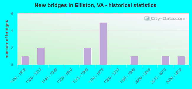
- New bridges - historical statistics
- 11920-1929
- 21930-1939
- 21960-1969
- 51970-1979
- 11990-1999
- 12010-2019
- 12020-2022


- Bridge Condition - Deck
- 12.5%Excellent
- 50.0%Good
- 12.5%Satisfactory
- 25.0%Fair

- Bridge Condition - Superstructure
- 12.5%Excellent
- 12.5%Very good
- 25.0%Good
- 12.5%Satisfactory
- 25.0%Fair
- 12.5%Poor

- Bridge Condition - Substructure
- 12.5%Excellent
- 12.5%Good
- 37.5%Satisfactory
- 37.5%Fair

- Bridge Condition - Channel
- 27.3%Very good
- 63.6%Satisfactory
- 9.1%Fair

- Bridge Condition - Culverts
- 25.0%Good
- 50.0%Satisfactory
- 25.0%Fair
Find on map >> Show street view
Structure Number: 12143, Location: 1.93-ROKE CO 10.06-RT11 (Lat: 37.235025, Lng: -80.235903), Route carried "on" structure: Interstate 81, Year Built: 1970, Status: Open, Structure Length: 10.58m (34.71ft), Average Daily Traffic: 21,913 (year 2020), Truck Traffic: 26%, Average Future Daily Traffic: 30,678 (year 2040), Design Load: HS 20+Mod, Features Intersected: NS RAILWAY & ROANOKE RV
Minimum Vertical Clearance: 30+ m (98+ ft), Kilometerpoint: 207.014, Lanes on structure: 3, Base Highway Network: Yes, Owner: State Highway Agency, Approaching Roadway Width: 11.0m (36.1ft), Skew: 4 degrees, Material/Design: Steel, Design/Construction: Stringer/Multi-beam, Number Of Spans In Main Unit: 4, Length of Maximum Span: 38.1m (125.0ft), Curb-To-Curb Width: 15.8m (51.8ft), Out-to-Out Width: 17.1m (56.1ft)
Condition: Deck: Satisfactory, Superstructure: Fair, Substructure: Fair, Channel: Very good, Operating Rating: 59.0 metric tons, Method Used To Determine Operating Rating: Load and Resistance Factor (LRFR), Inventory Rating: 45.4 metric tons, Method Used To Determine Inventory Rating: Load and Resistance Factor (LRFR), Structural Evaluation: Somewhat better than minimum adequacy, Deck Geometry: Somewhat better than minimum adequacy, Underclear: Somewhat better than minimum adequacy, Waterway Adequacy: Superior to present desirable criteria, Approach Roadway Alignment: Equal to present desirable criteria, Length Of Structure Improvement: 10.52m (34.51ft), Designated Inspection Frequency: Every 24 months, Inspection Date: Febuary 2020, Bridge Improvement Cost: $8,365,000, Roadway Improvement Cost: $1,000, Total Project Cost: $8,367,000 ( Estimate for 2014), Deck Structure Type: Concrete Cast-file-Place, Wearing Surface/Protective System: Wearing Surface: Latex Concrete
Find on map >> Show street view
Structure Number: 12144, Location: 10.04-RT11; 1.95-ROANO--C (Lat: 37.234950, Lng: -80.236317), Route carried "on" structure: Interstate 81, Year Built: 1970, Status: Open, Structure Length: 9.91m (32.51ft), Average Daily Traffic: 21,883 (year 2020), Truck Traffic: 26%, Average Future Daily Traffic: 30,636 (year 2040), Design Load: HS 20+Mod, Features Intersected: NS RAILWAY & ROANOKE RV
Minimum Vertical Clearance: 30+ m (98+ ft), Kilometerpoint: 207.899, Lanes on structure: 2, Base Highway Network: Yes, Owner: State Highway Agency, Approaching Roadway Width: 11.0m (36.1ft), Skew: 4 degrees, Material/Design: Steel, Design/Construction: Stringer/Multi-beam, Number Of Spans In Main Unit: 4, Length of Maximum Span: 35.4m (116.1ft), Curb or Sidewalk Widths: Left: 0.0m, Right: 0.3m (1.0ft), Curb-To-Curb Width: 12.2m (40.0ft), Out-to-Out Width: 13.4m (44.0ft)
Condition: Deck: Fair, Superstructure: Fair, Substructure: Fair, Channel: Very good, Operating Rating: 57.2 metric tons, Method Used To Determine Operating Rating: Load and Resistance Factor (LRFR), Inventory Rating: 43.5 metric tons, Method Used To Determine Inventory Rating: Load and Resistance Factor (LRFR), Structural Evaluation: Somewhat better than minimum adequacy, Deck Geometry: Better than present minimum criteria, Underclear: Somewhat better than minimum adequacy, Waterway Adequacy: Superior to present desirable criteria, Approach Roadway Alignment: Equal to present desirable criteria, Designated Inspection Frequency: Every 24 months, Inspection Date: January 2020, Deck Structure Type: Concrete Cast-file-Place, Wearing Surface/Protective System: Wearing Surface: Latex Concrete
Find on map >> Show street view
Structure Number: 12149, Location: 9.50 Rt 11; 0.4 Rt 603 (Lat: 37.228747, Lng: -80.242769), Route carried "on" structure: Interstate 81, Year Built: 1968, Status: Open, Structure Length: 0.67m (2.20ft), Average Daily Traffic: 18,909 (year 2020), Truck Traffic: 26%, Average Future Daily Traffic: 26,473 (year 2040), Design Load: HS 20, Features Intersected: Br. N Fork Roanoke River
Minimum Vertical Clearance: 30+ m (98+ ft), Kilometerpoint: 206.724, Lanes on structure: 3, Base Highway Network: Yes, Owner: State Highway Agency, Approaching Roadway Width: 14.6m (47.9ft), Skew: 4 degrees, Material/Design: Concrete, Design/Construction: Culvert, Number Of Spans In Main Unit: 3, Length of Maximum Span: 2.1m (6.9ft)
Condition: Channel: Satisfactory, Culverts: Fair, Operating Rating: 54.4 metric tons, Method Used To Determine Operating Rating: Field evaluation and documented engineering judgment, Inventory Rating: 32.7 metric tons, Method Used To Determine Inventory Rating: Field evaluation and documented engineering judgment, Structural Evaluation: Somewhat better than minimum adequacy, Waterway Adequacy: Better than present minimum criteria, Approach Roadway Alignment: Equal to present desirable criteria, Length Of Structure Improvement: 0.67m (2.20ft), Designated Inspection Frequency: Every 24 months, Inspection Date: April 2021, Bridge Improvement Cost: $388,000, Roadway Improvement Cost: $155,000, Total Project Cost: $1,338,000 ( Estimate for 2019)
Find on map >> Show street view
Structure Number: 12151, Location: 9.71 Rt 11; 0.15 Rt 603 (Lat: 37.230819, Lng: -80.239475), Route carried "on" structure: Interstate 81, Year Built: 1968, Status: Open, Structure Length: 0.67m (2.20ft), Average Daily Traffic: 41,279 (year 2020), Truck Traffic: 26%, Average Future Daily Traffic: 52,158 (year 2040), Design Load: HS 20, Features Intersected: Br. N Fork Roanoke River
Minimum Vertical Clearance: 30+ m (98+ ft), Kilometerpoint: 206.306, Lanes on structure: 5, Base Highway Network: Yes, Owner: State Highway Agency, Approaching Roadway Width: 25.6m (84.0ft), Skew: 24 degrees, Material/Design: Concrete, Design/Construction: Culvert, Number Of Spans In Main Unit: 3, Length of Maximum Span: 1.5m (4.9ft)
Condition: Channel: Satisfactory, Culverts: Satisfactory, Operating Rating: 54.4 metric tons, Method Used To Determine Operating Rating: Field evaluation and documented engineering judgment, Inventory Rating: 32.7 metric tons, Method Used To Determine Inventory Rating: Field evaluation and documented engineering judgment, Structural Evaluation: Equal to present minimum criteria, Waterway Adequacy: Better than present minimum criteria, Approach Roadway Alignment: Equal to present desirable criteria, Length Of Structure Improvement: 0.67m (2.20ft), Designated Inspection Frequency: Every 24 months, Inspection Date: April 2021, Bridge Improvement Cost: $435,000, Roadway Improvement Cost: $152,000, Total Project Cost: $1,284,000 ( Estimate for 2019)
Find on map >> Show street view
Structure Number: 12188, Location: 0.70-Rte629; 1.05-Rte635 (Lat: 37.232333, Lng: -80.254161), Route carried "on" structure: County highway 603, Year Built: 1970, Status: Open, Structure Length: 2.50m (8.20ft), Average Daily Traffic: 1,660 (year 2020), Truck Traffic: 4%, Average Future Daily Traffic: 1,826 (year 2040), Design Load: HS 20+Mod, Features Intersected: N Fork Roanoke River
Minimum Vertical Clearance: 30+ m (98+ ft), Kilometerpoint: 17.417, Lanes on structure: 2, Owner: State Highway Agency, Approaching Roadway Width: 6.4m (21.0ft), Material/Design: Steel, Design/Construction: Stringer/Multi-beam, Number Of Spans In Main Unit: 2, Length of Maximum Span: 12.5m (41.0ft), Curb or Sidewalk Widths: Left: 0.2m (0.7ft), Right: 0.2m (0.7ft), Curb-To-Curb Width: 9.4m (30.8ft), Out-to-Out Width: 10.4m (34.1ft)
Condition: Deck: Good, Superstructure: Good, Substructure: Good, Channel: Satisfactory, Operating Rating: 68.0 metric tons, Method Used To Determine Operating Rating: Load and Resistance Factor (LRFR), Inventory Rating: 52.6 metric tons, Method Used To Determine Inventory Rating: Load and Resistance Factor (LRFR), Structural Evaluation: Better than present minimum criteria, Deck Geometry: Somewhat better than minimum adequacy, Waterway Adequacy: Meets minimum limits, Approach Roadway Alignment: Equal to present minimum criteria, Length Of Structure Improvement: 2.59m (8.50ft), Designated Inspection Frequency: Every 24 months, Inspection Date: October 2021, Bridge Improvement Cost: $5,000, Roadway Improvement Cost: $1,000, Total Project Cost: $8,000 ( Estimate for 2017), Deck Structure Type: Concrete Cast-file-Place, Wearing Surface/Protective System: Wearing Surface: Epoxy Overlay
Find on map >> Show street view
Structure Number: 12197, Location: 0.10-RT 635; 1.60-RT 629 (Lat: 37.233025, Lng: -80.238375), Route carried "on" structure: County highway 603, Year Built: 1970, Status: Open, Structure Length: 8.73m (28.64ft), Average Daily Traffic: 1,442 (year 2020), Truck Traffic: 4%, Average Future Daily Traffic: 2,019 (year 2040), Design Load: HS 20+Mod, Features Intersected: RTE I 81
Minimum Vertical Clearance: 30+ m (98+ ft), Kilometerpoint: 18.761, Lanes on structure: 2, Lanes under structure: 4, Owner: State Highway Agency, Approaching Roadway Width: 6.7m (22.0ft), Skew: 3 degrees, Material/Design: Steel continuous, Design/Construction: Stringer/Multi-beam, Number Of Spans In Main Unit: 2, Number Of Approach Spans: 2, Length of Maximum Span: 25.5m (83.7ft), Curb or Sidewalk Widths: Left: 0.2m (0.7ft), Right: 0.2m (0.7ft), Curb-To-Curb Width: 9.0m (29.5ft), Out-to-Out Width: 10.1m (33.1ft)
Condition: Deck: Fair, Superstructure: Satisfactory, Substructure: Satisfactory, Operating Rating: 45.4 metric tons, Method Used To Determine Operating Rating: Load and Resistance Factor (LRFR), Inventory Rating: 29.0 metric tons, Method Used To Determine Inventory Rating: Load and Resistance Factor (LRFR), Structural Evaluation: Equal to present minimum criteria, Deck Geometry: Somewhat better than minimum adequacy, Underclear: Equal to present minimum criteria, Approach Roadway Alignment: Equal to present desirable criteria, Length Of Structure Improvement: 8.75m (28.71ft), Designated Inspection Frequency: Every 24 months, Inspection Date: Febuary 2020, Bridge Improvement Cost: $4,109,000, Roadway Improvement Cost: $1,000, Total Project Cost: $4,112,000 ( Estimate for 2014), Deck Structure Type: Concrete Cast-file-Place, Wearing Surface/Protective System: Wearing Surface: Epoxy Overlay
Find on map >> Show street view
Structure Number: 12234, Location: 1.20-RT603; 0.80-RT622 (Lat: 37.253975, Lng: -80.258278), Route carried "on" structure: County highway 629, Year Built: 1932, Year Reconstructed: 2008, Status: Open, Structure Length: 1.16m (3.81ft), Average Daily Traffic: 476 (year 2020), Truck Traffic: 1%, Average Future Daily Traffic: 524 (year 2040), Design Load: HS 20, Features Intersected: Bradshaw Creek
Minimum Vertical Clearance: 30+ m (98+ ft), Kilometerpoint: 1.931, Lanes on structure: 2, Owner: State Highway Agency, Approaching Roadway Width: 6.1m (20.0ft), Skew: 1 degrees, Material/Design: Steel, Design/Construction: Stringer/Multi-beam, Number Of Spans In Main Unit: 1, Length of Maximum Span: 11.6m (38.1ft), Curb or Sidewalk Widths: Left: 0.2m (0.7ft), Right: 0.2m (0.7ft), Curb-To-Curb Width: 5.7m (18.7ft), Out-to-Out Width: 6.0m (19.7ft)
Condition: Deck: Good, Superstructure: Good, Substructure: Satisfactory, Channel: Satisfactory, Operating Rating: 46.3 metric tons, Method Used To Determine Operating Rating: Load and Resistance Factor (LRFR), Inventory Rating: 35.4 metric tons, Method Used To Determine Inventory Rating: Load and Resistance Factor (LRFR), Structural Evaluation: Equal to present minimum criteria, Deck Geometry: High priority of replacement, Waterway Adequacy: Equal to present minimum criteria, Approach Roadway Alignment: Equal to present minimum criteria, Length Of Structure Improvement: 1.16m (3.81ft), Designated Inspection Frequency: Every 24 months, Inspection Date: Febuary 2022, Bridge Improvement Cost: $288,000, Roadway Improvement Cost: $29,000, Total Project Cost: $432,000 ( Estimate for 2014), Deck Structure Type: Wood or Timber, Wearing Surface/Protective System: Wearing Surface: Bituminous
Find on map >> Show street view
Structure Number: 12235, Location: 1.05-Rte603; 0.95-Rte622 (Lat: 37.252033, Lng: -80.259308), Route carried "on" structure: County highway 629, Year Built: 1921, Status: Temporarily open, Structure Length: 1.01m (3.31ft), Average Daily Traffic: 476 (year 2020), Truck Traffic: 1%, Average Future Daily Traffic: 524 (year 2040), Features Intersected: Bradshaw Creek
Minimum Vertical Clearance: 30+ m (98+ ft), Kilometerpoint: 1.689, Lanes on structure: 2, Owner: State Highway Agency, Approaching Roadway Width: 5.8m (19.0ft), Skew: 2 degrees, Material/Design: Steel continuous, Design/Construction: Stringer/Multi-beam, Number Of Spans In Main Unit: 2, Length of Maximum Span: 4.6m (15.1ft), Curb or Sidewalk Widths: Left: 0.2m (0.7ft), Right: 0.2m (0.7ft), Curb-To-Curb Width: 5.3m (17.4ft), Out-to-Out Width: 5.6m (18.4ft)
Condition: Deck: Good, Superstructure: Poor, Substructure: Fair, Channel: Satisfactory, Operating Rating: 38.1 metric tons, Method Used To Determine Operating Rating: Load Factor (LF), Inventory Rating: 22.7 metric tons, Method Used To Determine Inventory Rating: Load Factor (LF), Structural Evaluation: Meets minimum limits, Deck Geometry: High priority of replacement, Waterway Adequacy: Equal to present minimum criteria, Approach Roadway Alignment: Equal to present minimum criteria, Length Of Structure Improvement: 1.52m (4.99ft), Designated Inspection Frequency: Every 12 months, Inspection Date: November 2021, Bridge Improvement Cost: $530,000, Roadway Improvement Cost: $133,000, Total Project Cost: $1,696,000 ( Estimate for 2019), Deck Structure Type: Wood or Timber, Wearing Surface/Protective System: Wearing Surface: Bituminous
Find on map >> Show street view
Structure Number: 12238, Location: 0.30-Rte754; 0.30-Rte741 (Lat: 37.210711, Lng: -80.220122), Route carried "on" structure: County highway 631, Year Built: 1932, Status: Open, Structure Length: 0.73m (2.40ft), Average Daily Traffic: 788 (year 2016), Average Future Daily Traffic: 818 (year 2040), Design Load: HS 20, Features Intersected: Brake Branch
Minimum Vertical Clearance: 30+ m (98+ ft), Kilometerpoint: 2.584, Lanes on structure: 2, Owner: State Highway Agency, Approaching Roadway Width: 4.9m (16.1ft), Skew: 2 degrees, Material/Design: Steel, Design/Construction: Stringer/Multi-beam, Number Of Spans In Main Unit: 1, Length of Maximum Span: 7.3m (24.0ft), Curb or Sidewalk Widths: Left: 0.2m (0.7ft), Right: 0.2m (0.7ft), Curb-To-Curb Width: 5.2m (17.1ft), Out-to-Out Width: 5.5m (18.0ft)
Condition: Deck: Good, Superstructure: Very good, Substructure: Satisfactory, Channel: Satisfactory, Operating Rating: 59.0 metric tons, Method Used To Determine Operating Rating: Load and Resistance Factor (LRFR), Inventory Rating: 45.4 metric tons, Method Used To Determine Inventory Rating: Load and Resistance Factor (LRFR), Structural Evaluation: Equal to present minimum criteria, Deck Geometry: High priority of replacement, Waterway Adequacy: Somewhat better than minimum adequacy, Approach Roadway Alignment: Equal to present minimum criteria, Length Of Structure Improvement: 0.91m (2.99ft), Designated Inspection Frequency: Every 24 months, Inspection Date: August 2021, Bridge Improvement Cost: $294,000, Roadway Improvement Cost: $29,000, Total Project Cost: $441,000, Deck Structure Type: Wood or Timber, Wearing Surface/Protective System: Wearing Surface: Bituminous
Find on map >> Show street view
Structure Number: 12334, Location: 0.01 Rt 631; 0.89 D. End (Lat: 37.207100, Lng: -80.214700), Route carried "on" structure: County highway 741, Year Built: 1991, Status: Open, Structure Length: 0.94m (3.08ft), Average Daily Traffic: 155 (year 2019), Average Future Daily Traffic: 220 (year 2040), Design Load: HS 20+Mod, Features Intersected: Brake Branch
Minimum Vertical Clearance: 30+ m (98+ ft), Kilometerpoint: 0.016, Lanes on structure: 2, Owner: State Highway Agency, Approaching Roadway Width: 4.3m (14.1ft), Material/Design: Concrete, Design/Construction: Culvert, Number Of Spans In Main Unit: 3, Length of Maximum Span: 3.0m (9.8ft)
Condition: Channel: Fair, Culverts: Satisfactory, Operating Rating: 60.8 metric tons, Method Used To Determine Operating Rating: Load Factor (LF), Inventory Rating: 36.3 metric tons, Method Used To Determine Inventory Rating: Load Factor (LF), Structural Evaluation: Equal to present minimum criteria, Waterway Adequacy: Somewhat better than minimum adequacy, Approach Roadway Alignment: Equal to present desirable criteria, Length Of Structure Improvement: 0.94m (3.08ft), Designated Inspection Frequency: Every 24 months, Inspection Date: October 2021, Bridge Improvement Cost: $6,000, Roadway Improvement Cost: $1,000, Total Project Cost: $8,000 ( Estimate for 2017)
Find on map >> Show street view
Structure Number: 29544, Location: 0.05-Rte713; 1.70-Rte647 (Lat: 37.237617, Lng: -80.269083), Route carried "on" structure: County highway 603, Year Built: 2020, Status: Open, Structure Length: 1.25m (4.10ft), Average Daily Traffic: 694 (year 2020), Truck Traffic: 9%, Average Future Daily Traffic: 763 (year 2040), Design Load: HL 93, Features Intersected: Craig Branch, Facility Carried by Structure: North Fork Rd / Rt
Minimum Vertical Clearance: 30.18m (99.02ft), Kilometerpoint: 15.446, Lanes on structure: 2, Owner: State Highway Agency, Approaching Roadway Width: 5.5m (18.0ft), Skew: 3 degrees, Material/Design: Prestressed concrete, Design/Construction: Slab, Number Of Spans In Main Unit: 1, Length of Maximum Span: 11.1m (36.4ft), Curb or Sidewalk Widths: Left: 0.5m (1.6ft), Right: 0.5m (1.6ft), Curb-To-Curb Width: 8.1m (26.6ft), Out-to-Out Width: 9.1m (29.9ft)
Condition: Deck: Excellent, Superstructure: Excellent, Substructure: Excellent, Channel: Very good, Operating Rating: 71.7 metric tons, Method Used To Determine Operating Rating: Load and Resistance Factor (LRFR), Inventory Rating: 53.5 metric tons, Method Used To Determine Inventory Rating: Load and Resistance Factor (LRFR), Structural Evaluation: Superior to present desirable criteria, Deck Geometry: Somewhat better than minimum adequacy, Waterway Adequacy: Somewhat better than minimum adequacy, Approach Roadway Alignment: Equal to present minimum criteria, Designated Inspection Frequency: Every 24 months, Inspection Date: November 2020, Deck Structure Type: Concrete Precast Panels, Wearing Surface/Protective System: Wearing Surface: Bituminous, Membrane: Other, Deck Protection: Other
Find on map >> Show street view
Structure Number: 2999, Location: 1.80-Rt 11; 0.20-I-81 (Lat: 37.233828, Lng: -80.233639), Route carried "on" structure: County highway 603, Year Built: 2015, Status: Open, Structure Length: 0.74m (2.43ft), Average Daily Traffic: 992 (year 2020), Truck Traffic: 4%, Average Future Daily Traffic: 1,389 (year 2040), Design Load: HL 93, Features Intersected: PEDLAR CREEK, Facility Carried by Structure: NORTH FORK ROAD
Minimum Vertical Clearance: 30+ m (98+ ft), Kilometerpoint: 19.179, Lanes on structure: 2, Owner: State Highway Agency, Approaching Roadway Width: 11.3m (37.1ft), Skew: 3 degrees, Material/Design: Concrete, Design/Construction: Culvert, Number Of Spans In Main Unit: 2, Length of Maximum Span: 3.8m (12.5ft)
Condition: Channel: Satisfactory, Culverts: Good, Operating Rating: 89.8 metric tons, Method Used To Determine Operating Rating: Load Factor (LF), Inventory Rating: 71.7 metric tons, Method Used To Determine Inventory Rating: Load Factor (LF), Structural Evaluation: Better than present minimum criteria, Waterway Adequacy: Better than present minimum criteria, Approach Roadway Alignment: Equal to present desirable criteria, Designated Inspection Frequency: Every 24 months, Inspection Date: Febuary 2021
Find on map >> Show street view
Structure Number: 12197, Location: 0.10-RT 635; 1.60-RT 629 (Lat: 37.233025, Lng: -80.238375), Route carried "under" structure: Interstate 81, Year Built: 1970, Structure Length: 0. m, Average Daily Traffic: 26,605 (year 1994), Features Intersected: RTE I 81, Facility Carried by Structure: NORTH FORK RD/603
Minimum Vertical Clearance: 5.64m (18.50ft), Kilometerpoint: 37.779, Lanes on structure: 2, Lanes under structure: 4, Material/Design: Steel continuous, Design/Construction: Stringer/Multi-beam, Length of Maximum Span: 25.5m (83.7ft)