Bridge Statistics for Ellsworth, Kansas (KS)
Condition, Traffic, Stress, Structural Evaluation, Project Costs
- National Bridge Inventory (NBI) Statistics
- 35Number of bridges
- 315ft / 95.8mTotal length
- $495,000Total costs
- 39,547Total average daily traffic
- 6,777Total average daily truck traffic
- National Bridge Inventory (NBI) Registered Bridges for Ellsworth
- No street view available for this location
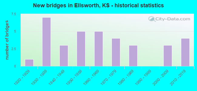
- New bridges - historical statistics
- 11920-1929
- 71930-1939
- 31940-1949
- 51950-1959
- 51960-1969
- 41970-1979
- 31980-1989
- 32000-2009
- 42010-2019
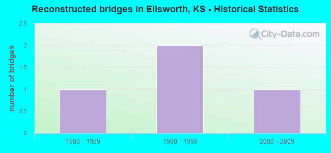
- Reconstructed bridges - Historical Statistics
- 11980-1989
- 21990-1999
- 12000-2009
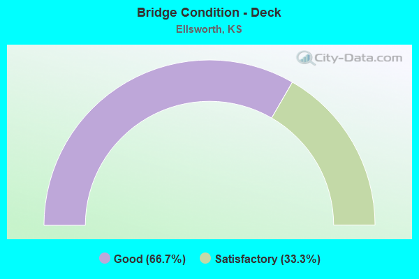
- Bridge Condition - Deck
- 66.7%Good
- 33.3%Satisfactory
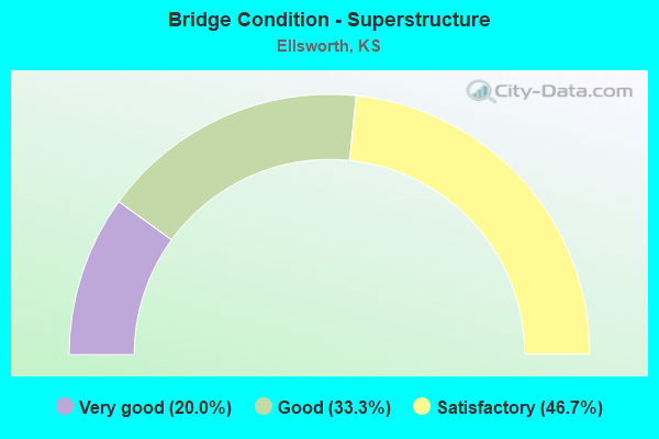
- Bridge Condition - Superstructure
- 20.0%Very good
- 33.3%Good
- 46.7%Satisfactory
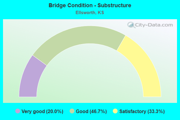
- Bridge Condition - Substructure
- 20.0%Very good
- 46.7%Good
- 33.3%Satisfactory
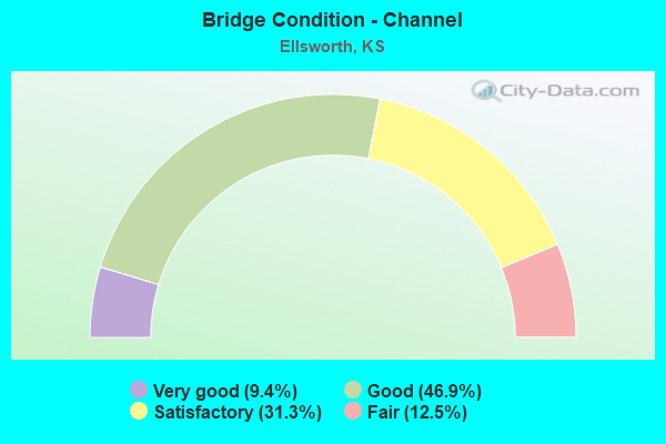
- Bridge Condition - Channel
- 9.4%Very good
- 46.9%Good
- 31.3%Satisfactory
- 12.5%Fair
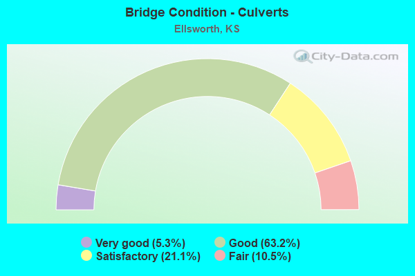
- Bridge Condition - Culverts
- 5.3%Very good
- 63.2%Good
- 21.1%Satisfactory
- 10.5%Fair
Find on map >> Show street view
Structure Number: 27013, Location: 1.2S 1.6E OF ELLSWORTH (Lat: 38.711892, Lng: -98.202194), Route carried "on" structure: County highway 238, Year Built: 1979, Status: Open, Structure Length: 3.70m (12.14ft), Average Daily Traffic: 915 (year 2017), Truck Traffic: 10%, Average Future Daily Traffic: 1,100 (year 2040), Design Load: H 20, Features Intersected: OAK CREEK, Facility Carried by Structure: L Road
Minimum Vertical Clearance: 30.47m (99.97ft), Kilometerpoint: 0.000, Lanes on structure: 2, Owner: County Highway Agency, Approaching Roadway Width: 6.7m (22.0ft), Material/Design: Prestressed concrete continuous, Design/Construction: Tee Beam, Number Of Spans In Main Unit: 3, Length of Maximum Span: 12.2m (40.0ft), Curb-To-Curb Width: 9.1m (29.9ft), Out-to-Out Width: 9.7m (31.8ft)
Condition: Deck: Good, Superstructure: Good, Substructure: Good, Channel: Good, Operating Rating: 59.5 metric tons, Method Used To Determine Operating Rating: Load Factor (LF), Inventory Rating: 28.3 metric tons, Method Used To Determine Inventory Rating: Load Factor (LF), Structural Evaluation: Better than present minimum criteria, Deck Geometry: Equal to present minimum criteria, Waterway Adequacy: Equal to present minimum criteria, Approach Roadway Alignment: Better than present minimum criteria, Designated Inspection Frequency: Every 24 months, Inspection Date: August 2020, Other Special Inspection Date: August 2020, Deck Structure Type: Concrete Cast-file-Place, Wearing Surface/Protective System: Wearing Surface: Monolithic Concrete
Find on map >> Show street view
Structure Number: 27014, Location: 1.3S 1.8E OF ELLSWORTH (Lat: 38.710286, Lng: -98.196861), Route carried "on" structure: County highway 238, Year Built: 1957, Status: Posted for load, Structure Length: 0.63m (2.07ft), Average Daily Traffic: 960 (year 2017), Truck Traffic: 10%, Average Future Daily Traffic: 1,155 (year 2040), Design Load: H 15, Features Intersected: TRIB. SMOKY HILL RIVER, Facility Carried by Structure: L Road
Minimum Vertical Clearance: 30.47m (99.97ft), Kilometerpoint: 0.000, Lanes on structure: 2, Owner: County Highway Agency, Approaching Roadway Width: 6.3m (20.7ft), Material/Design: Concrete, Design/Construction: Culvert, Number Of Spans In Main Unit: 2, Length of Maximum Span: 3.0m (9.8ft)
Condition: Channel: Good, Culverts: Good, Operating Rating: 23.2 metric tons, Method Used To Determine Operating Rating: Load Factor (LF), Inventory Rating: 13.9 metric tons, Method Used To Determine Inventory Rating: Load Factor (LF), Structural Evaluation: Meets minimum limits, Waterway Adequacy: Equal to present minimum criteria, Approach Roadway Alignment: Better than present minimum criteria, Bridge Posting: Required (Relationship of Operating Rating to Maximum Legal Load: 30.0 - 39.9% below), Designated Inspection Frequency: Every 24 months, Inspection Date: August 2020, Other Special Inspection Date: August 2020, Deck Structure Type: Concrete Cast-file-Place, Wearing Surface/Protective System: Wearing Surface: Bituminous
Find on map >> Show street view
Structure Number: 27041, Location: 0.4S 2.2W OF KANOPOLIS (Lat: 38.705500, Lng: -98.197544), Route carried "on" structure: County highway 692, Year Built: 1940, Status: Posted for load, Structure Length: 14.35m (47.08ft), Average Daily Traffic: 105 (year 2017), Truck Traffic: 10%, Average Future Daily Traffic: 125 (year 2040), Features Intersected: SMOKY HILL RIVER, Facility Carried by Structure: 16th Road
Minimum Vertical Clearance: 30.47m (99.97ft), Kilometerpoint: 0.000, Lanes on structure: 2, Owner: County Highway Agency, Approaching Roadway Width: 6.7m (22.0ft), Material/Design: Steel continuous, Design/Construction: Girder and Floorbeam System, Number Of Spans In Main Unit: 4, Length of Maximum Span: 38.4m (126.0ft), Curb or Sidewalk Widths: Left: 0.3m (1.0ft), Right: 0.3m (1.0ft), Curb-To-Curb Width: 7.3m (24.0ft), Out-to-Out Width: 7.7m (25.3ft)
Condition: Deck: Satisfactory, Superstructure: Satisfactory, Substructure: Good, Channel: Good, Operating Rating: 36.3 metric tons, Method Used To Determine Operating Rating: Allowable Stress (AS), Inventory Rating: 20.0 metric tons, Method Used To Determine Inventory Rating: Allowable Stress (AS), Structural Evaluation: Somewhat better than minimum adequacy, Deck Geometry: Somewhat better than minimum adequacy, Waterway Adequacy: Equal to present minimum criteria, Approach Roadway Alignment: Better than present minimum criteria, Designated Inspection Frequency: Every 24 months, Critical Feature Inspection Frequency: Every 24 months, Inspection Date: March 2020, Critical Feature Inspection Date: May 2020, Deck Structure Type: Concrete Cast-file-Place, Wearing Surface/Protective System: Wearing Surface: Monolithic Concrete
Find on map >> Show street view
Structure Number: 27065, Location: 0.7N 2.4W OF ELLSWORTH (Lat: 38.740733, Lng: -98.278297), Route carried "on" structure: County highway 2020, Year Built: 1934, Status: Open, Structure Length: 0.88m (2.89ft), Average Daily Traffic: 990 (year 2017), Truck Traffic: 10%, Average Future Daily Traffic: 1,190 (year 2040), Features Intersected: TRIB TO SMOKY HILL RIVER, Facility Carried by Structure: Old Hwy 40
Minimum Vertical Clearance: 30.47m (99.97ft), Kilometerpoint: 0.000, Lanes on structure: 2, Owner: County Highway Agency, Approaching Roadway Width: 7.1m (23.3ft), Material/Design: Concrete, Design/Construction: Culvert, Number Of Spans In Main Unit: 2, Length of Maximum Span: 4.3m (14.1ft), Curb or Sidewalk Widths: Left: 0.1m (0.3ft), Right: 0.1m (0.3ft)
Condition: Channel: Fair, Culverts: Fair, Operating Rating: 55.5 metric tons, Method Used To Determine Operating Rating: Load Factor (LF), Inventory Rating: 33.2 metric tons, Method Used To Determine Inventory Rating: Load Factor (LF), Structural Evaluation: Somewhat better than minimum adequacy, Waterway Adequacy: Equal to present minimum criteria, Approach Roadway Alignment: Better than present minimum criteria, Designated Inspection Frequency: Every 24 months, Inspection Date: Febuary 2020, Deck Structure Type: Concrete Cast-file-Place, Wearing Surface/Protective System: Wearing Surface: Bituminous
Find on map >> Show street view
Structure Number: 27066, Location: 0.7N 1.4W OF ELLSWORTH (Lat: 38.740300, Lng: -98.258942), Route carried "on" structure: County highway 2020, Year Built: 1934, Status: Open, Structure Length: 0.76m (2.49ft), Average Daily Traffic: 990 (year 2017), Truck Traffic: 10%, Average Future Daily Traffic: 1,190 (year 2040), Design Load: H 20, Features Intersected: TRIB TO SMOKY HILL RIVER, Facility Carried by Structure: Old Hwy 40
Minimum Vertical Clearance: 30.47m (99.97ft), Kilometerpoint: 0.000, Lanes on structure: 2, Owner: County Highway Agency, Approaching Roadway Width: 8.2m (26.9ft), Material/Design: Concrete, Design/Construction: Culvert, Number Of Spans In Main Unit: 2, Length of Maximum Span: 3.7m (12.1ft), Curb or Sidewalk Widths: Left: 0.4m (1.3ft), Right: 0.4m (1.3ft)
Condition: Channel: Satisfactory, Culverts: Good, Operating Rating: 46.4 metric tons, Method Used To Determine Operating Rating: Load Factor (LF), Inventory Rating: 27.8 metric tons, Method Used To Determine Inventory Rating: Load Factor (LF), Structural Evaluation: Equal to present minimum criteria, Waterway Adequacy: Equal to present minimum criteria, Approach Roadway Alignment: Better than present minimum criteria, Designated Inspection Frequency: Every 24 months, Inspection Date: Febuary 2020, Deck Structure Type: Concrete Cast-file-Place, Wearing Surface/Protective System: Wearing Surface: Bituminous
Find on map >> Show street view
Structure Number: 27067, Location: 0.5W 0.7N OF ELLSWORTH (Lat: 38.740244, Lng: -98.245539), Route carried "on" structure: County highway 2020, Year Built: 1934, Status: Open, Structure Length: 0.78m (2.56ft), Average Daily Traffic: 990 (year 2017), Truck Traffic: 10%, Average Future Daily Traffic: 1,190 (year 2040), Design Load: H 20, Features Intersected: TRIB TO SMOKY HILL RIVER, Facility Carried by Structure: 2nd Rd
Minimum Vertical Clearance: 30.47m (99.97ft), Kilometerpoint: 0.000, Lanes on structure: 2, Owner: County Highway Agency, Approaching Roadway Width: 7.4m (24.3ft), Material/Design: Concrete, Design/Construction: Culvert, Number Of Spans In Main Unit: 3, Length of Maximum Span: 7.3m (24.0ft), Curb or Sidewalk Widths: Left: 0.4m (1.3ft), Right: 0.4m (1.3ft), Curb-To-Curb Width: 7.3m (24.0ft), Out-to-Out Width: 7.3m (24.0ft)
Condition: Channel: Satisfactory, Culverts: Satisfactory, Operating Rating: 94.1 metric tons, Method Used To Determine Operating Rating: Load Factor (LF), Inventory Rating: 56.3 metric tons, Method Used To Determine Inventory Rating: Load Factor (LF), Structural Evaluation: Equal to present minimum criteria, Deck Geometry: Meets minimum limits, Waterway Adequacy: Equal to present minimum criteria, Approach Roadway Alignment: Better than present minimum criteria, Designated Inspection Frequency: Every 24 months, Inspection Date: Febuary 2020, Deck Structure Type: Concrete Cast-file-Place, Wearing Surface/Protective System: Wearing Surface: Bituminous
Find on map >> Show street view
Structure Number: 270675, Location: W. EDGE CITY OF ELLSWORTH (Lat: 38.740239, Lng: -98.241461), Route carried "on" structure: County highway 2020, Year Built: 1934, Year Reconstructed: 1988, Status: Open, Structure Length: 0.94m (3.08ft), Average Daily Traffic: 990 (year 2017), Truck Traffic: 10%, Average Future Daily Traffic: 1,190 (year 2040), Features Intersected: TRIB. SMOKY HILL RIVER, Facility Carried by Structure: Old Hwy 40
Minimum Vertical Clearance: 30.47m (99.97ft), Kilometerpoint: 0.000, Lanes on structure: 2, Owner: County Highway Agency, Approaching Roadway Width: 7.1m (23.3ft), Material/Design: Concrete, Design/Construction: Culvert, Number Of Spans In Main Unit: 3, Length of Maximum Span: 3.0m (9.8ft), Curb or Sidewalk Widths: Left: 0.4m (1.3ft), Right: 0.4m (1.3ft), Curb-To-Curb Width: 11.0m (36.1ft), Out-to-Out Width: 11.7m (38.4ft)
Condition: Channel: Satisfactory, Culverts: Good, Operating Rating: 32.4 metric tons, Method Used To Determine Operating Rating: Allowable Stress (AS), Inventory Rating: 24.3 metric tons, Method Used To Determine Inventory Rating: Allowable Stress (AS), Structural Evaluation: Equal to present minimum criteria, Deck Geometry: Better than present minimum criteria, Waterway Adequacy: Equal to present minimum criteria, Approach Roadway Alignment: Better than present minimum criteria, Designated Inspection Frequency: Every 24 months, Inspection Date: Febuary 2020, Deck Structure Type: Concrete Cast-file-Place, Wearing Surface/Protective System: Wearing Surface: Bituminous
Find on map >> Show street view
Structure Number: 2707159048, Location: 2.3S 3.8W OF ELLSWORTH (Lat: 38.696719, Lng: -98.296161), Route carried "on" structure: County highway , Year Built: 1977, Year Reconstructed: 2011, Status: Open, Structure Length: 1.40m (4.59ft), Average Daily Traffic: 20 (year 2014), Truck Traffic: 5%, Average Future Daily Traffic: 25 (year 2040), Features Intersected: TURKEY CREEK, Facility Carried by Structure: Ave M
Minimum Vertical Clearance: 30.47m (99.97ft), Kilometerpoint: 0.000, Lanes on structure: 2, Owner: County Highway Agency, Approaching Roadway Width: 4.8m (15.7ft), Material/Design: Steel continuous, Design/Construction: Stringer/Multi-beam, Number Of Spans In Main Unit: 2, Length of Maximum Span: 9.1m (29.9ft), Curb-To-Curb Width: 4.4m (14.4ft), Out-to-Out Width: 5.1m (16.7ft)
Condition: Deck: Satisfactory, Superstructure: Satisfactory, Substructure: Satisfactory, Channel: Fair, Operating Rating: 78.6 metric tons, Method Used To Determine Operating Rating: Load Factor (LF), Inventory Rating: 47.1 metric tons, Method Used To Determine Inventory Rating: Load Factor (LF), Structural Evaluation: Equal to present minimum criteria, Deck Geometry: High priority of replacement, Waterway Adequacy: Equal to present minimum criteria, Approach Roadway Alignment: Equal to present minimum criteria, Length Of Structure Improvement: 2.13m (6.99ft), Designated Inspection Frequency: Every 24 months, Inspection Date: Febuary 2020, Bridge Improvement Cost: $284,000, Roadway Improvement Cost: $32,000, Total Project Cost: $315,000 ( Estimate for 2020), Deck Structure Type: Other, Wearing Surface/Protective System: Wearing Surface: Gravel
Find on map >> Show street view
Structure Number: 2707190047, Location: 2.6W 2.7N OF ELLSWORTH (Lat: 38.769333, Lng: -98.281178), Route carried "on" structure: County highway , Year Built: 1947, Status: Posted for load, Structure Length: 0.64m (2.10ft), Average Daily Traffic: 35 (year 2014), Truck Traffic: 5%, Average Future Daily Traffic: 45 (year 2040), Design Load: H 20, Features Intersected: TRIB. TO SMOKY HILL RIV., Facility Carried by Structure: H Road
Minimum Vertical Clearance: 30.47m (99.97ft), Kilometerpoint: 0.000, Lanes on structure: 2, Owner: County Highway Agency, Approaching Roadway Width: 4.2m (13.8ft), Material/Design: Concrete, Design/Construction: Culvert, Number Of Spans In Main Unit: 2, Length of Maximum Span: 3.0m (9.8ft), Curb or Sidewalk Widths: Left: 0.3m (1.0ft), Right: 0.3m (1.0ft), Curb-To-Curb Width: 8.5m (27.9ft), Out-to-Out Width: 9.3m (30.5ft)
Condition: Channel: Good, Culverts: Good, Operating Rating: 34.0 metric tons, Method Used To Determine Operating Rating: Load Factor (LF), Inventory Rating: 20.4 metric tons, Method Used To Determine Inventory Rating: Load Factor (LF), Structural Evaluation: Somewhat better than minimum adequacy, Deck Geometry: Better than present minimum criteria, Waterway Adequacy: Equal to present minimum criteria, Approach Roadway Alignment: Better than present minimum criteria, Bridge Posting: Required (Relationship of Operating Rating to Maximum Legal Load: 20.0 - 29.9% below), Designated Inspection Frequency: Every 24 months, Inspection Date: August 2020, Other Special Inspection Date: August 2020, Deck Structure Type: Concrete Cast-file-Place, Wearing Surface/Protective System: Wearing Surface: Gravel
Find on map >> Show street view
Structure Number: 270719804822, Location: 1.8W 3.5S OF ELLSWORTH (Lat: 38.678972, Lng: -98.258325), Route carried "on" structure: County highway , Year Built: 1928, Status: Posted for load, Structure Length: 0.70m (2.30ft), Average Daily Traffic: 30 (year 2014), Truck Traffic: 5%, Average Future Daily Traffic: 35 (year 2040), Features Intersected: TRIB. TO OXIDE CK., Facility Carried by Structure: 13th Road
Minimum Vertical Clearance: 30.47m (99.97ft), Kilometerpoint: 0.000, Lanes on structure: 2, Owner: County Highway Agency, Approaching Roadway Width: 6.7m (22.0ft), Material/Design: Steel, Design/Construction: Stringer/Multi-beam, Number Of Spans In Main Unit: 1, Length of Maximum Span: 6.5m (21.3ft), Curb-To-Curb Width: 5.2m (17.1ft), Out-to-Out Width: 5.5m (18.0ft)
Condition: Deck: Satisfactory, Superstructure: Satisfactory, Substructure: Satisfactory, Channel: Fair, Operating Rating: 33.7 metric tons, Method Used To Determine Operating Rating: Load Factor (LF), Inventory Rating: 20.2 metric tons, Method Used To Determine Inventory Rating: Load Factor (LF), Structural Evaluation: Somewhat better than minimum adequacy, Deck Geometry: High priority of corrective action, Waterway Adequacy: Equal to present minimum criteria, Approach Roadway Alignment: Better than present minimum criteria, Length Of Structure Improvement: 1.22m (4.00ft), Designated Inspection Frequency: Every 24 months, Inspection Date: March 2020, Bridge Improvement Cost: $162,000, Roadway Improvement Cost: $18,000, Total Project Cost: $180,000 ( Estimate for 2020), Deck Structure Type: Concrete Cast-file-Place, Wearing Surface/Protective System: Wearing Surface: Gravel
Find on map >> Show street view
Structure Number: 270723004742, Location: W. EDGE OF ELLSWORTH (Lat: 38.738214, Lng: -98.243831), Route carried "on" structure: County highway , Year Built: 1988, Status: Open, Structure Length: 0.62m (2.03ft), Average Daily Traffic: 20 (year 2014), Truck Traffic: 5%, Average Future Daily Traffic: 25 (year 2040), Design Load: H 20, Features Intersected: TRIB. SMOKY HILL RIVER, Facility Carried by Structure: 14th Road
Minimum Vertical Clearance: 30.47m (99.97ft), Kilometerpoint: 0.000, Lanes on structure: 2, Owner: County Highway Agency, Approaching Roadway Width: 6.0m (19.7ft), Material/Design: Concrete, Design/Construction: Culvert, Number Of Spans In Main Unit: 2, Length of Maximum Span: 3.0m (9.8ft), Curb or Sidewalk Widths: Left: 0.2m (0.7ft), Right: 0.2m (0.7ft), Curb-To-Curb Width: 7.3m (24.0ft), Out-to-Out Width: 7.8m (25.6ft)
Condition: Channel: Fair, Culverts: Good, Operating Rating: 43.2 metric tons, Method Used To Determine Operating Rating: Allowable Stress (AS), Inventory Rating: 32.4 metric tons, Method Used To Determine Inventory Rating: Allowable Stress (AS), Structural Evaluation: Better than present minimum criteria, Deck Geometry: Equal to present minimum criteria, Waterway Adequacy: Equal to present minimum criteria, Approach Roadway Alignment: Better than present minimum criteria, Designated Inspection Frequency: Every 24 months, Inspection Date: March 2020, Deck Structure Type: Concrete Cast-file-Place, Wearing Surface/Protective System: Wearing Surface: Gravel
Find on map >> Show street view
Structure Number: 27072320466, Location: 0.5W 4.7N OF ELLSWORTH (Lat: 38.798317, Lng: -98.239722), Route carried "on" structure: County highway , Year Built: 1974, Status: Open, Structure Length: 1.23m (4.04ft), Average Daily Traffic: 60 (year 2014), Truck Traffic: 5%, Average Future Daily Traffic: 70 (year 2040), Features Intersected: WEST OAK CREEK, Facility Carried by Structure: F Road
Minimum Vertical Clearance: 30.47m (99.97ft), Kilometerpoint: 0.000, Lanes on structure: 2, Owner: County Highway Agency, Approaching Roadway Width: 6.7m (22.0ft), Skew: 4 degrees, Material/Design: Steel continuous, Design/Construction: Stringer/Multi-beam, Number Of Spans In Main Unit: 2, Length of Maximum Span: 6.1m (20.0ft), Curb-To-Curb Width: 7.3m (24.0ft), Out-to-Out Width: 7.4m (24.3ft)
Condition: Deck: Good, Superstructure: Satisfactory, Substructure: Satisfactory, Channel: Satisfactory, Operating Rating: 43.2 metric tons, Method Used To Determine Operating Rating: Load Factor (LF), Inventory Rating: 32.4 metric tons, Method Used To Determine Inventory Rating: Load Factor (LF), Structural Evaluation: Equal to present minimum criteria, Deck Geometry: Equal to present minimum criteria, Waterway Adequacy: Equal to present minimum criteria, Approach Roadway Alignment: Better than present minimum criteria, Designated Inspection Frequency: Every 24 months, Inspection Date: March 2020, Deck Structure Type: Corrugated Steel, Wearing Surface/Protective System: Wearing Surface: Gravel
Find on map >> Show street view
Structure Number: 27072380476, Location: NE MAIN AT NEBRASKA AVE (Lat: 38.725278, Lng: -98.226389), Route carried "on" structure: City street 533, Year Built: 2016, Status: Open, Structure Length: 0.63m (2.07ft), Average Daily Traffic: 150 (year 2019), Truck Traffic: 1%, Average Future Daily Traffic: 216 (year 2041), Design Load: HL 93, Features Intersected: DRAINAGE, Facility Carried by Structure: NE MAIN ST
Minimum Vertical Clearance: 30.47m (99.97ft), Kilometerpoint: 0.000, Lanes on structure: 2, Owner: City or Municipal Highway Agency, Approaching Roadway Width: 9.1m (29.9ft), Skew: 4 degrees, Material/Design: Concrete, Design/Construction: Culvert, Number Of Spans In Main Unit: 2, Length of Maximum Span: 3.0m (9.8ft), Curb or Sidewalk Widths: Left: 0.2m (0.7ft), Right: 0.2m (0.7ft)
Condition: Channel: Satisfactory, Culverts: Good, Operating Rating: 62.9 metric tons, Method Used To Determine Operating Rating: Load and Resistance Factor Rating (LRFR) rating reported by rating factor(RF) method using HL-93 loadings, Inventory Rating: 48.3 metric tons, Method Used To Determine Inventory Rating: Load and Resistance Factor Rating (LRFR) rating reported by rating factor(RF) method using HL-93 loadings, Structural Evaluation: Better than present minimum criteria, Waterway Adequacy: Equal to present desirable criteria, Approach Roadway Alignment: Equal to present desirable criteria, Designated Inspection Frequency: Every 24 months, Inspection Date: December 2021
Find on map >> Show street view
Structure Number: 270725104761, Location: NE MAIN AT WEST ST (Lat: 38.724097, Lng: -98.224217), Route carried "on" structure: City street 288, Year Built: 2016, Status: Open, Structure Length: 0.96m (3.15ft), Average Daily Traffic: 150 (year 2019), Truck Traffic: 1%, Average Future Daily Traffic: 216 (year 2041), Design Load: HL 93, Features Intersected: DRAINAGE, Facility Carried by Structure: NE MAIN ST
Minimum Vertical Clearance: 30.47m (99.97ft), Kilometerpoint: 0.000, Lanes on structure: 2, Owner: City or Municipal Highway Agency, Approaching Roadway Width: 9.1m (29.9ft), Skew: 4 degrees, Material/Design: Concrete, Design/Construction: Culvert, Number Of Spans In Main Unit: 3, Length of Maximum Span: 3.0m (9.8ft)
Condition: Channel: Satisfactory, Culverts: Good, Operating Rating: 62.9 metric tons, Method Used To Determine Operating Rating: Load and Resistance Factor Rating (LRFR) rating reported by rating factor(RF) method using HL-93 loadings, Inventory Rating: 48.3 metric tons, Method Used To Determine Inventory Rating: Load and Resistance Factor Rating (LRFR) rating reported by rating factor(RF) method using HL-93 loadings, Structural Evaluation: Better than present minimum criteria, Waterway Adequacy: Better than present minimum criteria, Approach Roadway Alignment: Equal to present desirable criteria, Designated Inspection Frequency: Every 24 months, Inspection Date: December 2021
Find on map >> Show street view
Structure Number: 27072540466, Location: 0.7E 4.7N OF ELLSWORTH (Lat: 38.798114, Lng: -98.217633), Route carried "on" structure: County highway , Year Built: 1959, Status: Posted for load, Structure Length: 1.14m (3.74ft), Average Daily Traffic: 60 (year 2014), Truck Traffic: 5%, Average Future Daily Traffic: 70 (year 2040), Design Load: H 15, Features Intersected: TRIB. TO OAK CREEK, Facility Carried by Structure: F Road
Minimum Vertical Clearance: 30.47m (99.97ft), Kilometerpoint: 0.000, Lanes on structure: 2, Owner: County Highway Agency, Approaching Roadway Width: 7.2m (23.6ft), Material/Design: Concrete, Design/Construction: Culvert, Number Of Spans In Main Unit: 3, Length of Maximum Span: 3.7m (12.1ft), Curb or Sidewalk Widths: Left: 0.3m (1.0ft), Right: 0.3m (1.0ft), Curb-To-Curb Width: 8.5m (27.9ft), Out-to-Out Width: 9.1m (29.9ft)
Condition: Channel: Good, Culverts: Good, Operating Rating: 25.3 metric tons, Method Used To Determine Operating Rating: Load Factor (LF), Inventory Rating: 15.1 metric tons, Method Used To Determine Inventory Rating: Load Factor (LF), Structural Evaluation: Meets minimum limits, Deck Geometry: Better than present minimum criteria, Waterway Adequacy: Equal to present minimum criteria, Approach Roadway Alignment: Better than present minimum criteria, Bridge Posting: Required (Relationship of Operating Rating to Maximum Legal Load: 30.0 - 39.9% below), Designated Inspection Frequency: Every 24 months, Inspection Date: August 2020, Other Special Inspection Date: August 2020, Deck Structure Type: Concrete Cast-file-Place, Wearing Surface/Protective System: Wearing Surface: Gravel
Find on map >> Show street view
Structure Number: 2707254047, Location: 0.7E 2.7N OF ELLSWORTH (Lat: 38.769111, Lng: -98.216050), Route carried "on" structure: County highway , Year Built: 2010, Status: Open, Structure Length: 1.85m (6.07ft), Average Daily Traffic: 40 (year 2014), Truck Traffic: 5%, Average Future Daily Traffic: 45 (year 2040), Features Intersected: OAK CREEK, Facility Carried by Structure: H Road
Minimum Vertical Clearance: 30.47m (99.97ft), Kilometerpoint: 0.000, Lanes on structure: 2, Owner: County Highway Agency, Approaching Roadway Width: 4.8m (15.7ft), Material/Design: Steel continuous, Design/Construction: Stringer/Multi-beam, Number Of Spans In Main Unit: 2, Length of Maximum Span: 9.1m (29.9ft), Curb-To-Curb Width: 7.3m (24.0ft), Out-to-Out Width: 7.3m (24.0ft)
Condition: Deck: Good, Superstructure: Good, Substructure: Good, Channel: Good, Operating Rating: 66.4 metric tons, Method Used To Determine Operating Rating: Load Factor (LF), Inventory Rating: 39.7 metric tons, Method Used To Determine Inventory Rating: Load Factor (LF), Structural Evaluation: Better than present minimum criteria, Deck Geometry: Equal to present minimum criteria, Waterway Adequacy: Equal to present minimum criteria, Approach Roadway Alignment: Better than present minimum criteria, Designated Inspection Frequency: Every 24 months, Inspection Date: August 2020, Other Special Inspection Date: August 2020, Deck Structure Type: Corrugated Steel, Wearing Surface/Protective System: Wearing Surface: Gravel
Find on map >> Show street view
Structure Number: 27072580472, Location: 1.1E 1.7N OF ELLSWORTH (Lat: 38.754581, Lng: -98.209867), Route carried "on" structure: County highway , Year Built: 1958, Status: Open, Structure Length: 1.84m (6.04ft), Average Daily Traffic: 30 (year 2014), Truck Traffic: 5%, Average Future Daily Traffic: 35 (year 2040), Features Intersected: OAK CREEK, Facility Carried by Structure: H Road
Minimum Vertical Clearance: 30.47m (99.97ft), Kilometerpoint: 0.000, Lanes on structure: 2, Owner: County Highway Agency, Approaching Roadway Width: 6.7m (22.0ft), Material/Design: Steel continuous, Design/Construction: Stringer/Multi-beam, Number Of Spans In Main Unit: 2, Length of Maximum Span: 9.0m (29.5ft), Curb-To-Curb Width: 7.3m (24.0ft), Out-to-Out Width: 7.5m (24.6ft)
Condition: Deck: Satisfactory, Superstructure: Satisfactory, Substructure: Satisfactory, Channel: Satisfactory, Operating Rating: 59.0 metric tons, Method Used To Determine Operating Rating: Allowable Stress (AS), Inventory Rating: 35.4 metric tons, Method Used To Determine Inventory Rating: Allowable Stress (AS), Structural Evaluation: Equal to present minimum criteria, Deck Geometry: Equal to present minimum criteria, Waterway Adequacy: Equal to present minimum criteria, Approach Roadway Alignment: Better than present minimum criteria, Designated Inspection Frequency: Every 24 months, Inspection Date: March 2020, Deck Structure Type: Corrugated Steel, Wearing Surface/Protective System: Wearing Surface: Gravel
Find on map >> Show street view
Structure Number: 27072730466, Location: 1.5E 4.7N OF ELLSWORTH (Lat: 38.798022, Lng: -98.201389), Route carried "on" structure: County highway , Year Built: 1959, Status: Open, Structure Length: 0.75m (2.46ft), Average Daily Traffic: 50 (year 2014), Truck Traffic: 5%, Average Future Daily Traffic: 60 (year 2040), Design Load: H 15, Features Intersected: EAST OAK CREEK, Facility Carried by Structure: F Road
Minimum Vertical Clearance: 30.47m (99.97ft), Kilometerpoint: 0.000, Lanes on structure: 2, Owner: County Highway Agency, Approaching Roadway Width: 4.2m (13.8ft), Material/Design: Concrete, Design/Construction: Culvert, Number Of Spans In Main Unit: 2, Length of Maximum Span: 3.7m (12.1ft), Curb or Sidewalk Widths: Left: 0.3m (1.0ft), Right: 0.3m (1.0ft), Curb-To-Curb Width: 8.5m (27.9ft), Out-to-Out Width: 9.1m (29.9ft)
Condition: Channel: Satisfactory, Culverts: Satisfactory, Operating Rating: 36.0 metric tons, Method Used To Determine Operating Rating: Load Factor (LF), Inventory Rating: 21.6 metric tons, Method Used To Determine Inventory Rating: Load Factor (LF), Structural Evaluation: Equal to present minimum criteria, Deck Geometry: Better than present minimum criteria, Waterway Adequacy: Equal to present minimum criteria, Approach Roadway Alignment: Better than present minimum criteria, Designated Inspection Frequency: Every 24 months, Inspection Date: August 2020, Other Special Inspection Date: August 2020, Deck Structure Type: Concrete Cast-file-Place, Wearing Surface/Protective System: Wearing Surface: Gravel
Find on map >> Show street view
Structure Number: 270727704745, Location: 2.0E OF ELLSWORTH (Lat: 38.732728, Lng: -98.193750), Route carried "on" structure: County highway , Year Built: 1936, Status: Posted for load, Structure Length: 0.64m (2.10ft), Average Daily Traffic: 40 (year 2014), Truck Traffic: 5%, Average Future Daily Traffic: 45 (year 2040), Features Intersected: TRIB. TO SMOKY HILL RIV., Facility Carried by Structure: JJ Road
Minimum Vertical Clearance: 30.47m (99.97ft), Kilometerpoint: 0.000, Lanes on structure: 2, Owner: County Highway Agency, Approaching Roadway Width: 6.7m (22.0ft), Material/Design: Concrete, Design/Construction: Culvert, Number Of Spans In Main Unit: 2, Length of Maximum Span: 3.0m (9.8ft), Curb-To-Curb Width: 6.1m (20.0ft), Out-to-Out Width: 6.7m (22.0ft)
Condition: Channel: Satisfactory, Culverts: Satisfactory, Operating Rating: 26.1 metric tons, Method Used To Determine Operating Rating: Allowable Stress (AS), Inventory Rating: 19.8 metric tons, Method Used To Determine Inventory Rating: Allowable Stress (AS), Structural Evaluation: Somewhat better than minimum adequacy, Deck Geometry: Somewhat better than minimum adequacy, Waterway Adequacy: Equal to present minimum criteria, Approach Roadway Alignment: Better than present minimum criteria, Designated Inspection Frequency: Every 24 months, Inspection Date: March 2020, Deck Structure Type: Concrete Cast-file-Place, Wearing Surface/Protective System: Wearing Surface: Gravel
Find on map >> Show street view
Structure Number: 27072790472, Location: 1.7N 2.2E OF ELLSWORTH (Lat: 38.754508, Lng: -98.188403), Route carried "on" structure: County highway , Year Built: 2003, Status: Open, Structure Length: 0.79m (2.59ft), Average Daily Traffic: 40 (year 2014), Truck Traffic: 5%, Average Future Daily Traffic: 45 (year 2040), Design Load: HS 20, Features Intersected: TRIB. TO SMOKY HILL RIV., Facility Carried by Structure: H Road
Minimum Vertical Clearance: 30.47m (99.97ft), Kilometerpoint: 0.000, Lanes on structure: 2, Owner: County Highway Agency, Approaching Roadway Width: 6.7m (22.0ft), Material/Design: Steel, Design/Construction: Stringer/Multi-beam, Number Of Spans In Main Unit: 1, Length of Maximum Span: 7.6m (24.9ft), Curb-To-Curb Width: 7.4m (24.3ft), Out-to-Out Width: 7.6m (24.9ft)
Condition: Deck: Good, Superstructure: Satisfactory, Substructure: Good, Channel: Satisfactory, Operating Rating: 64.8 metric tons, Method Used To Determine Operating Rating: Load Factor (LF), Inventory Rating: 38.8 metric tons, Method Used To Determine Inventory Rating: Load Factor (LF), Structural Evaluation: Equal to present minimum criteria, Deck Geometry: Equal to present minimum criteria, Waterway Adequacy: Equal to present minimum criteria, Approach Roadway Alignment: Better than present minimum criteria, Designated Inspection Frequency: Every 24 months, Inspection Date: March 2020, Deck Structure Type: Corrugated Steel, Wearing Surface/Protective System: Wearing Surface: Gravel
Find on map >> Show street view
Structure Number: 999901400270371, Location: 0.78 MI N US156 (Lat: 38.723333, Lng: -98.234444), Route carried "on" structure: State highway 14, Year Built: 1939, Status: Open, Structure Length: 0.77m (2.53ft), Average Daily Traffic: 1,565 (year 2020), Truck Traffic: 12%, Average Future Daily Traffic: 1,695 (year 2041), Design Load: H 15, Features Intersected: SMOKY HILL RIVER DRN
Minimum Vertical Clearance: 30.47m (99.97ft), Kilometerpoint: 23.641, Lanes on structure: 2, Base Highway Network: Yes, Owner: State Highway Agency, Approaching Roadway Width: 7.3m (24.0ft), Material/Design: Concrete, Design/Construction: Culvert, Number Of Spans In Main Unit: 2, Length of Maximum Span: 3.7m (12.1ft), Curb-To-Curb Width: 9.8m (32.2ft), Out-to-Out Width: 10.5m (34.4ft)
Condition: Channel: Good, Culverts: Good, Operating Rating: 31.8 metric tons, Method Used To Determine Operating Rating: Load Factor (LF), Inventory Rating: 19.1 metric tons, Method Used To Determine Inventory Rating: Load Factor (LF), Structural Evaluation: Somewhat better than minimum adequacy, Deck Geometry: Somewhat better than minimum adequacy, Waterway Adequacy: Somewhat better than minimum adequacy, Approach Roadway Alignment: Somewhat better than minimum adequacy, Length Of Structure Improvement: 2.52m (8.27ft), Designated Inspection Frequency: Every 24 months, Inspection Date: April 2020, Deck Structure Type: Concrete Cast-file-Place, Wearing Surface/Protective System: Wearing Surface: Bituminous
Find on map >> Show street view
Structure Number: 999901400270391, Location: 1.76 MI N K-156 (Lat: 38.734722, Lng: -98.225833), Route carried "on" structure: State highway 14, Year Built: 1932, Status: Open, Structure Length: 0.75m (2.46ft), Average Daily Traffic: 1,795 (year 2020), Truck Traffic: 4%, Average Future Daily Traffic: 1,944 (year 2041), Design Load: H 15, Features Intersected: SMOKY HILL RIVER DRN
Minimum Vertical Clearance: 30.47m (99.97ft), Kilometerpoint: 25.144, Lanes on structure: 2, Base Highway Network: Yes, Owner: State Highway Agency, Approaching Roadway Width: 9.1m (29.9ft), Skew: 4 degrees, Material/Design: Concrete, Design/Construction: Culvert, Number Of Spans In Main Unit: 2, Length of Maximum Span: 2.4m (7.9ft), Curb-To-Curb Width: 9.8m (32.2ft), Out-to-Out Width: 10.5m (34.4ft)
Condition: Channel: Good, Culverts: Satisfactory, Operating Rating: 33.0 metric tons, Method Used To Determine Operating Rating: Load Factor (LF), Inventory Rating: 19.8 metric tons, Method Used To Determine Inventory Rating: Load Factor (LF), Structural Evaluation: Somewhat better than minimum adequacy, Deck Geometry: Somewhat better than minimum adequacy, Waterway Adequacy: Equal to present minimum criteria, Approach Roadway Alignment: Meets minimum limits, Length Of Structure Improvement: 2.47m (8.10ft), Designated Inspection Frequency: Every 24 months, Inspection Date: October 2021, Deck Structure Type: Concrete Cast-file-Place, Wearing Surface/Protective System: Wearing Surface: Bituminous
Find on map >> Show street view
Structure Number: 999901400270401, Location: 3.32 MI N K140 (Lat: 38.788056, Lng: -98.224722), Route carried "on" structure: State highway 14, Year Built: 1953, Status: Open, Structure Length: 1.45m (4.76ft), Average Daily Traffic: 1,105 (year 2020), Truck Traffic: 22%, Average Future Daily Traffic: 1,348 (year 2041), Design Load: H 20, Features Intersected: WEST OAK CREEK
Minimum Vertical Clearance: 30.47m (99.97ft), Kilometerpoint: 31.096, Lanes on structure: 2, Base Highway Network: Yes, Owner: State Highway Agency, Approaching Roadway Width: 7.3m (24.0ft), Skew: 3 degrees, Material/Design: Concrete, Design/Construction: Culvert, Number Of Spans In Main Unit: 2, Length of Maximum Span: 6.1m (20.0ft), Curb-To-Curb Width: 8.5m (27.9ft), Out-to-Out Width: 9.3m (30.5ft)
Condition: Channel: Good, Culverts: Fair, Operating Rating: 41.7 metric tons, Method Used To Determine Operating Rating: Load Factor (LF), Inventory Rating: 25.4 metric tons, Method Used To Determine Inventory Rating: Load Factor (LF), Structural Evaluation: Somewhat better than minimum adequacy, Deck Geometry: Somewhat better than minimum adequacy, Waterway Adequacy: Somewhat better than minimum adequacy, Approach Roadway Alignment: Somewhat better than minimum adequacy, Length Of Structure Improvement: 4.77m (15.65ft), Designated Inspection Frequency: Every 24 months, Inspection Date: April 2020, Deck Structure Type: Concrete Cast-file-Place, Wearing Surface/Protective System: Wearing Surface: Bituminous
Find on map >> Show street view
Structure Number: 999901400270581, Location: 1.84 MI N K140 (Lat: 38.766389, Lng: -98.224722), Route carried "on" structure: State highway 14, Year Built: 1978, Status: Open, Structure Length: 1.53m (5.02ft), Average Daily Traffic: 1,105 (year 2020), Truck Traffic: 22%, Average Future Daily Traffic: 1,348 (year 2041), Design Load: H 20, Features Intersected: OAK CREEK DRAINAGE
Minimum Vertical Clearance: 30.47m (99.97ft), Kilometerpoint: 28.669, Lanes on structure: 2, Base Highway Network: Yes, Owner: State Highway Agency, Approaching Roadway Width: 7.3m (24.0ft), Material/Design: Concrete, Design/Construction: Culvert, Number Of Spans In Main Unit: 4, Length of Maximum Span: 3.7m (12.1ft), Curb-To-Curb Width: 13.4m (44.0ft), Out-to-Out Width: 14.0m (45.9ft)
Condition: Channel: Very good, Culverts: Good, Operating Rating: 65.8 metric tons, Method Used To Determine Operating Rating: Load Factor (LF), Inventory Rating: 39.4 metric tons, Method Used To Determine Inventory Rating: Load Factor (LF), Structural Evaluation: Better than present minimum criteria, Deck Geometry: Equal to present desirable criteria, Waterway Adequacy: Equal to present desirable criteria, Approach Roadway Alignment: Better than present minimum criteria, Length Of Structure Improvement: 5.02m (16.47ft), Designated Inspection Frequency: Every 24 months, Inspection Date: April 2020, Deck Structure Type: Concrete Cast-file-Place, Wearing Surface/Protective System: Wearing Surface: Bituminous
Find on map >> Show street view
Structure Number: 999901400270601, Location: 1.040MI N US156 (Lat: 38.726667, Lng: -98.233611), Route carried "on" structure: State highway 14, Year Built: 1982, Status: Open, Structure Length: 11.51m (37.76ft), Average Daily Traffic: 1,565 (year 2020), Truck Traffic: 12%, Average Future Daily Traffic: 1,695 (year 2041), Design Load: HS 20, Features Intersected: SMOKY HILL RIVER
Minimum Vertical Clearance: 30.47m (99.97ft), Kilometerpoint: 24.005, Lanes on structure: 2, Base Highway Network: Yes, Owner: State Highway Agency, Approaching Roadway Width: 12.2m (40.0ft), Material/Design: Steel continuous, Design/Construction: Stringer/Multi-beam, Number Of Spans In Main Unit: 4, Length of Maximum Span: 32.6m (107.0ft), Curb or Sidewalk Widths: Left: 1.2m (3.9ft), Right: 1.2m (3.9ft), Curb-To-Curb Width: 12.2m (40.0ft), Out-to-Out Width: 16.0m (52.5ft)
Condition: Deck: Good, Superstructure: Good, Substructure: Satisfactory, Channel: Good, Operating Rating: 46.4 metric tons, Method Used To Determine Operating Rating: Load Factor (LF), Inventory Rating: 27.8 metric tons, Method Used To Determine Inventory Rating: Load Factor (LF), Structural Evaluation: Equal to present minimum criteria, Deck Geometry: Better than present minimum criteria, Waterway Adequacy: Meets minimum limits, Approach Roadway Alignment: Meets minimum limits, Length Of Structure Improvement: 37.75m (123.85ft), Designated Inspection Frequency: Every 24 months, Inspection Date: April 2020, Deck Structure Type: Concrete Cast-file-Place, Wearing Surface/Protective System: Wearing Surface: Monolithic Concrete, Deck Protection: Epoxy Coated Reinforcing
Find on map >> Show street view
Structure Number: 999901400270641, Location: 12.88 MI N RICE COLN (Lat: 38.702222, Lng: -98.219722), Route carried "on" structure: State highway 14, Year Built: 2004, Status: Open, Structure Length: 5.02m (16.47ft), Average Daily Traffic: 1,450 (year 2020), Truck Traffic: 19%, Average Future Daily Traffic: 1,769 (year 2041), Design Load: HL 93, Features Intersected: OXIDE CREEK
Minimum Vertical Clearance: 30.47m (99.97ft), Kilometerpoint: 20.712, Lanes on structure: 2, Base Highway Network: Yes, Owner: State Highway Agency, Approaching Roadway Width: 11.0m (36.1ft), Material/Design: Prestressed concrete continuous, Design/Construction: Tee Beam, Number Of Spans In Main Unit: 3, Length of Maximum Span: 20.6m (67.6ft), Curb-To-Curb Width: 11.0m (36.1ft), Out-to-Out Width: 11.6m (38.1ft)
Condition: Deck: Good, Superstructure: Very good, Substructure: Very good, Channel: Good, Operating Rating: 68.4 metric tons, Method Used To Determine Operating Rating: Load and Resistance Factor Rating (LRFR) rating reported by rating factor(RF) method using HL-93 loadings, Inventory Rating: 52.5 metric tons, Method Used To Determine Inventory Rating: Load and Resistance Factor Rating (LRFR) rating reported by rating factor(RF) method using HL-93 loadings, Structural Evaluation: Equal to present desirable criteria, Deck Geometry: Equal to present minimum criteria, Waterway Adequacy: Equal to present desirable criteria, Approach Roadway Alignment: Better than present minimum criteria, Length Of Structure Improvement: 16.46m (54.00ft), Designated Inspection Frequency: Every 24 months, Inspection Date: April 2020, Wearing Surface/Protective System: Wearing Surface: Monolithic Concrete, Deck Protection: Epoxy Coated Reinforcing
Find on map >> Show street view
Structure Number: 999914000270591, Location: 0.40 MI E K156 (Lat: 38.740000, Lng: -98.208333), Route carried "on" structure: State highway 140, Year Built: 1981, Status: Open, Structure Length: 4.95m (16.24ft), Average Daily Traffic: 1,490 (year 2020), Truck Traffic: 15%, Average Future Daily Traffic: 1,582 (year 2041), Design Load: HS 20, Features Intersected: OAK CREEK
Minimum Vertical Clearance: 30.47m (99.97ft), Kilometerpoint: 1.437, Lanes on structure: 2, Base Highway Network: Yes, Owner: State Highway Agency, Approaching Roadway Width: 8.5m (27.9ft), Material/Design: Concrete continuous, Design/Construction: Slab, Number Of Spans In Main Unit: 3, Length of Maximum Span: 19.5m (64.0ft), Curb-To-Curb Width: 12.2m (40.0ft), Out-to-Out Width: 12.8m (42.0ft)
Condition: Deck: Good, Superstructure: Good, Substructure: Very good, Channel: Good, Operating Rating: 70.8 metric tons, Method Used To Determine Operating Rating: Load Factor (LF), Inventory Rating: 42.6 metric tons, Method Used To Determine Inventory Rating: Load Factor (LF), Structural Evaluation: Better than present minimum criteria, Deck Geometry: Better than present minimum criteria, Waterway Adequacy: Better than present minimum criteria, Approach Roadway Alignment: Better than present minimum criteria, Length Of Structure Improvement: 16.25m (53.31ft), Designated Inspection Frequency: Every 24 months, Inspection Date: May 2020, Deck Structure Type: Concrete Cast-file-Place, Wearing Surface/Protective System: Wearing Surface: Low Slump Concrete
Find on map >> Show street view
Structure Number: 999914000270681, Location: 1.13 MI E K-156 (Lat: 38.739722, Lng: -98.194722), Route carried "on" structure: State highway 140, Year Built: 2015, Status: Open, Structure Length: 0.77m (2.53ft), Average Daily Traffic: 1,490 (year 2020), Truck Traffic: 15%, Average Future Daily Traffic: 1,582 (year 2041), Design Load: HL 93, Features Intersected: SMOKY HILL RIVER DRN
Minimum Vertical Clearance: 30.47m (99.97ft), Kilometerpoint: 2.618, Lanes on structure: 2, Base Highway Network: Yes, Owner: State Highway Agency, Approaching Roadway Width: 7.3m (24.0ft), Material/Design: Concrete, Design/Construction: Culvert, Number Of Spans In Main Unit: 3, Length of Maximum Span: 2.4m (7.9ft), Curb-To-Curb Width: 12.2m (40.0ft), Out-to-Out Width: 22.6m (74.1ft)
Condition: Channel: Very good, Culverts: Very good, Operating Rating: 85.5 metric tons, Method Used To Determine Operating Rating: Load and Resistance Factor Rating (LRFR) rating reported by rating factor(RF) method using HL-93 loadings, Inventory Rating: 65.8 metric tons, Method Used To Determine Inventory Rating: Load and Resistance Factor Rating (LRFR) rating reported by rating factor(RF) method using HL-93 loadings, Structural Evaluation: Equal to present desirable criteria, Deck Geometry: Better than present minimum criteria, Waterway Adequacy: Equal to present desirable criteria, Approach Roadway Alignment: Meets minimum limits, Length Of Structure Improvement: 2.53m (8.30ft), Designated Inspection Frequency: Every 24 months, Inspection Date: May 2020, Wearing Surface/Protective System: Wearing Surface: Bituminous, Deck Protection: Epoxy Coated Reinforcing
Find on map >> Show street view
Structure Number: 999915000570371, Location: 1.87 MI E US56 (Lat: 38.362778, Lng: -96.932222), Route carried "on" structure: State highway 150, Year Built: 1941, Year Reconstructed: 2002, Status: Open, Structure Length: 0.63m (2.07ft), Average Daily Traffic: 1,585 (year 2020), Truck Traffic: 48%, Average Future Daily Traffic: 2,052 (year 2041), Design Load: H 15, Features Intersected: MARTIN CREEK DRAINAGE
Minimum Vertical Clearance: 30.47m (99.97ft), Kilometerpoint: 3.006, Lanes on structure: 2, Base Highway Network: Yes, Owner: State Highway Agency, Approaching Roadway Width: 9.8m (32.2ft), Material/Design: Concrete, Design/Construction: Culvert, Number Of Spans In Main Unit: 2, Length of Maximum Span: 3.0m (9.8ft), Curb-To-Curb Width: 12.2m (40.0ft), Out-to-Out Width: 23.5m (77.1ft)
Condition: Channel: Very good, Culverts: Good, Operating Rating: 31.0 metric tons, Method Used To Determine Operating Rating: Load Factor (LF), Inventory Rating: 18.6 metric tons, Method Used To Determine Inventory Rating: Load Factor (LF), Structural Evaluation: Somewhat better than minimum adequacy, Deck Geometry: Better than present minimum criteria, Waterway Adequacy: Equal to present desirable criteria, Approach Roadway Alignment: Equal to present desirable criteria, Length Of Structure Improvement: 2.08m (6.82ft), Designated Inspection Frequency: Every 24 months, Inspection Date: November 2021, Deck Structure Type: Concrete Cast-file-Place, Wearing Surface/Protective System: Wearing Surface: Monolithic Concrete
Find on map >> Show street view
Structure Number: 999915600270231, Location: 0.77 MI NE K14 (Lat: 38.719722, Lng: -98.224444), Route carried "on" structure: State highway 156, Year Built: 1961, Year Reconstructed: 2002, Status: Open, Structure Length: 11.99m (39.34ft), Average Daily Traffic: 4,355 (year 2020), Truck Traffic: 17%, Average Future Daily Traffic: 5,639 (year 2041), Design Load: HS 20, Features Intersected: SMOKY HILL RIVER
Minimum Vertical Clearance: 30.47m (99.97ft), Kilometerpoint: 29.721, Lanes on structure: 2, Base Highway Network: Yes, Owner: State Highway Agency, Approaching Roadway Width: 13.4m (44.0ft), Material/Design: Steel continuous, Design/Construction: Stringer/Multi-beam, Number Of Spans In Main Unit: 4, Length of Maximum Span: 32.9m (107.9ft), Curb-To-Curb Width: 13.4m (44.0ft), Out-to-Out Width: 14.0m (45.9ft)
Condition: Deck: Good, Superstructure: Very good, Substructure: Good, Channel: Good, Operating Rating: 67.9 metric tons, Method Used To Determine Operating Rating: Load Factor (LF), Inventory Rating: 28.0 metric tons, Method Used To Determine Inventory Rating: Load Factor (LF), Structural Evaluation: Better than present minimum criteria, Deck Geometry: Better than present minimum criteria, Waterway Adequacy: Equal to present minimum criteria, Approach Roadway Alignment: Equal to present desirable criteria, Length Of Structure Improvement: 39.35m (129.10ft), Designated Inspection Frequency: Every 24 months, Inspection Date: April 2020, Deck Structure Type: Concrete Cast-file-Place, Wearing Surface/Protective System: Wearing Surface: Monolithic Concrete
Find on map >> Show street view
Structure Number: 999915600270251, Location: 1.29 MI NE K14 (Lat: 38.726111, Lng: -98.219722), Route carried "on" structure: ServiceCity street 55, Year Built: 1961, Status: Open, Structure Length: 4.28m (14.04ft), Average Daily Traffic: 332 (year 2020), Truck Traffic: 1%, Average Future Daily Traffic: 5,529 (year 2041), Design Load: H 15, Features Intersected: K156 HWY, Facility Carried by Structure: LOCAL ROAD
Minimum Vertical Clearance: 30.47m (99.97ft), Kilometerpoint: 0.362, Lanes on structure: 2, Lanes under structure: 2, Owner: State Highway Agency, Approaching Roadway Width: 7.9m (25.9ft), Material/Design: Concrete continuous, Design/Construction: Slab, Number Of Spans In Main Unit: 3, Length of Maximum Span: 16.5m (54.1ft), Curb-To-Curb Width: 7.9m (25.9ft), Out-to-Out Width: 9.6m (31.5ft)
Condition: Deck: Good, Superstructure: Good, Substructure: Good, Operating Rating: 44.5 metric tons, Method Used To Determine Operating Rating: Load Factor (LF), Inventory Rating: 26.3 metric tons, Method Used To Determine Inventory Rating: Load Factor (LF), Structural Evaluation: Equal to present minimum criteria, Deck Geometry: Somewhat better than minimum adequacy, Underclear: Equal to present minimum criteria, Approach Roadway Alignment: Somewhat better than minimum adequacy, Length Of Structure Improvement: 14.05m (46.10ft), Designated Inspection Frequency: Every 24 months, Inspection Date: April 2020, Deck Structure Type: Concrete Cast-file-Place, Wearing Surface/Protective System: Wearing Surface: Monolithic Concrete
Find on map >> Show street view
Structure Number: 999915600270261, Location: 1.13 MI NE K140 (Lat: 38.756111, Lng: -98.214167), Route carried "on" structure: State highway 156, Year Built: 1965, Status: Open, Structure Length: 4.74m (15.55ft), Average Daily Traffic: 3,030 (year 2020), Truck Traffic: 26%, Average Future Daily Traffic: 3,923 (year 2041), Design Load: HS 20, Features Intersected: OAK CREEK
Minimum Vertical Clearance: 30.47m (99.97ft), Kilometerpoint: 33.996, Lanes on structure: 2, Base Highway Network: Yes, Owner: State Highway Agency, Approaching Roadway Width: 13.4m (44.0ft), Material/Design: Concrete continuous, Design/Construction: Tee Beam, Number Of Spans In Main Unit: 3, Length of Maximum Span: 19.2m (63.0ft), Curb-To-Curb Width: 13.4m (44.0ft), Out-to-Out Width: 14.0m (45.9ft)
Condition: Deck: Satisfactory, Superstructure: Satisfactory, Substructure: Good, Channel: Good, Operating Rating: 51.9 metric tons, Method Used To Determine Operating Rating: Load Factor (LF), Inventory Rating: 31.1 metric tons, Method Used To Determine Inventory Rating: Load Factor (LF), Structural Evaluation: Equal to present minimum criteria, Deck Geometry: Better than present minimum criteria, Waterway Adequacy: Equal to present minimum criteria, Approach Roadway Alignment: Somewhat better than minimum adequacy, Length Of Structure Improvement: 15.55m (51.02ft), Designated Inspection Frequency: Every 24 months, Inspection Date: April 2020, Deck Structure Type: Concrete Cast-file-Place, Wearing Surface/Protective System: Wearing Surface: Low Slump Concrete
Find on map >> Show street view
Structure Number: 999915600270271, Location: 3.72 MI NE K140 (Lat: 38.778889, Lng: -98.176111), Route carried "on" structure: State highway 156, Year Built: 1965, Status: Open, Structure Length: 0.75m (2.46ft), Average Daily Traffic: 3,030 (year 2020), Truck Traffic: 26%, Average Future Daily Traffic: 3,923 (year 2041), Design Load: H 20, Features Intersected: SPRING CREEK
Minimum Vertical Clearance: 30.47m (99.97ft), Kilometerpoint: 38.159, Lanes on structure: 2, Base Highway Network: Yes, Owner: State Highway Agency, Approaching Roadway Width: 13.4m (44.0ft), Material/Design: Concrete, Design/Construction: Culvert, Number Of Spans In Main Unit: 2, Length of Maximum Span: 3.7m (12.1ft), Curb-To-Curb Width: 13.4m (44.0ft), Out-to-Out Width: 13.9m (45.6ft)
Condition: Channel: Good, Culverts: Good, Operating Rating: 37.2 metric tons, Method Used To Determine Operating Rating: Load Factor (LF), Inventory Rating: 22.7 metric tons, Method Used To Determine Inventory Rating: Load Factor (LF), Structural Evaluation: Equal to present minimum criteria, Deck Geometry: Better than present minimum criteria, Waterway Adequacy: Equal to present minimum criteria, Approach Roadway Alignment: Equal to present desirable criteria, Length Of Structure Improvement: 2.47m (8.10ft), Designated Inspection Frequency: Every 24 months, Inspection Date: April 2020, Deck Structure Type: Concrete Cast-file-Place, Wearing Surface/Protective System: Wearing Surface: Bituminous
Find on map >> Show street view
Structure Number: 999915600270651, Location: 1.01 MI NE K-14 HIGHWAY (Lat: 38.722778, Lng: -98.222222), Route carried "on" structure: State highway 156, Year Built: 2002, Status: Open, Structure Length: 11.43m (37.50ft), Average Daily Traffic: 4,355 (year 2020), Truck Traffic: 17%, Average Future Daily Traffic: 5,639 (year 2041), Design Load: HS 25 or greater, Features Intersected: RS-238; UP RR
Minimum Vertical Clearance: 30.47m (99.97ft), Kilometerpoint: 30.114, Lanes on structure: 3, Lanes under structure: 2, Base Highway Network: Yes, Owner: State Highway Agency, Approaching Roadway Width: 15.9m (52.2ft), Skew: 1 degrees, Material/Design: Steel continuous, Design/Construction: Stringer/Multi-beam, Number Of Spans In Main Unit: 5, Length of Maximum Span: 29.0m (95.1ft), Curb-To-Curb Width: 15.9m (52.2ft), Out-to-Out Width: 16.7m (54.8ft)
Condition: Deck: Good, Superstructure: Very good, Substructure: Very good, Operating Rating: 80.5 metric tons, Method Used To Determine Operating Rating: Load Factor (LF), Inventory Rating: 48.3 metric tons, Method Used To Determine Inventory Rating: Load Factor (LF), Structural Evaluation: Equal to present desirable criteria, Deck Geometry: Better than present minimum criteria, Underclear: Superior to present desirable criteria, Approach Roadway Alignment: Somewhat better than minimum adequacy, Length Of Structure Improvement: 37.49m (123.00ft), Designated Inspection Frequency: Every 24 months, Inspection Date: April 2020, Wearing Surface/Protective System: Wearing Surface: Low Slump Concrete, Deck Protection: Epoxy Coated Reinforcing
Find on map >> Show street view
Structure Number: 999915600270251, Location: 1.29 MI NE K14 (Lat: 38.726111, Lng: -98.219722), Route carried "under" structure: State highway 156, Year Built: 1961, Structure Length: 0. m, Average Daily Traffic: 4,630 (year 2020), Truck Traffic: 15%, Features Intersected: K156 HWY, Facility Carried by Structure: LOCAL ROAD
Minimum Vertical Clearance: 5.61m (18.41ft), Kilometerpoint: 30.571, Lanes on structure: 2, Lanes under structure: 2, Material/Design: Concrete continuous, Design/Construction: Slab, Length of Maximum Span: 16.5m (54.1ft)