Bridge Statistics for Ellwood City, Pennsylvania (PA)
Condition, Traffic, Stress, Structural Evaluation, Project Costs
- National Bridge Inventory (NBI) Statistics
- 11Number of bridges
- 246ft / 74.9mTotal length
- $4,785,000Total costs
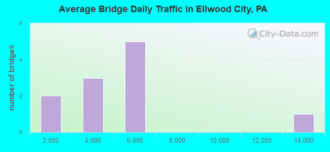
- 49,394Total average daily traffic
- 2,103Total average daily truck traffic
- National Bridge Inventory (NBI) Registered Bridges for Ellwood City
- No street view available for this location
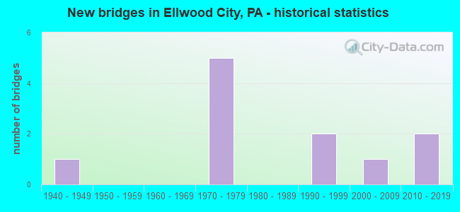
- New bridges - historical statistics
- 11940-1949
- 51970-1979
- 21990-1999
- 12000-2009
- 22010-2019
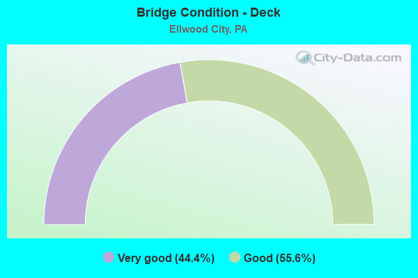
- Bridge Condition - Deck
- 44.4%Very good
- 55.6%Good
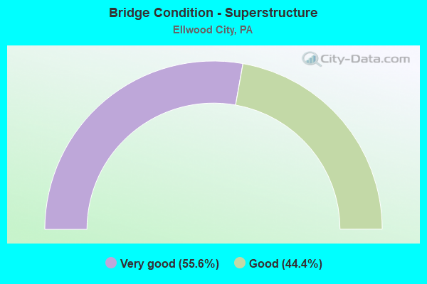
- Bridge Condition - Superstructure
- 55.6%Very good
- 44.4%Good
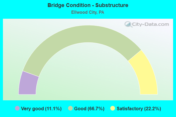
- Bridge Condition - Substructure
- 11.1%Very good
- 66.7%Good
- 22.2%Satisfactory
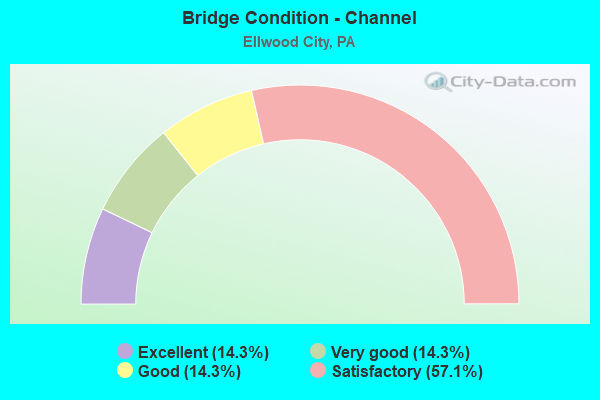
- Bridge Condition - Channel
- 14.3%Excellent
- 14.3%Very good
- 14.3%Good
- 57.1%Satisfactory
Find on map >> Show street view
Structure Number: 3554, Location: N.B. @ INTER. W/SR 0288 (Lat: 40.847389, Lng: -80.276439), Route carried "on" structure: State highway 65, Year Built: 1976, Status: Open, Structure Length: 8.56m (28.08ft), Average Daily Traffic: 4,733 (year 2022), Truck Traffic: 5%, Average Future Daily Traffic: 5,124 (year 2032), Design Load: HS 20, Features Intersected: CONNOQUENESSING CREEK, Facility Carried by Structure: MERCER RD
Minimum Vertical Clearance: 30+ m (98+ ft), Kilometerpoint: 28.645, Lanes on structure: 2, Owner: State Highway Agency, Approaching Roadway Width: 11.0m (36.1ft), Skew: 10 degrees, Material/Design: Prestressed concrete, Design/Construction: Stringer/Multi-beam, Number Of Spans In Main Unit: 3, Length of Maximum Span: 27.7m (90.9ft), Curb or Sidewalk Widths: Left: 0.2m (0.7ft), Right: 1.5m (4.9ft), Curb-To-Curb Width: 11.9m (39.0ft), Out-to-Out Width: 15.1m (49.5ft)
Condition: Deck: Very good, Superstructure: Good, Substructure: Good, Channel: Satisfactory, Inventory Rating: 31.8 metric tons, Method Used To Determine Inventory Rating: Load Factor (LF), Structural Evaluation: Better than present minimum criteria, Deck Geometry: Better than present minimum criteria, Waterway Adequacy: Equal to present desirable criteria, Approach Roadway Alignment: Equal to present desirable criteria, Length Of Structure Improvement: 8.60m (28.22ft), Designated Inspection Frequency: Every 24 months, Inspection Date: October 2020, Bridge Improvement Cost: $79,000, Roadway Improvement Cost: $233,000, Total Project Cost: $1,068,000, Deck Structure Type: Concrete Cast-file-Place, Wearing Surface/Protective System: Wearing Surface: Latex Concrete, Deck Protection: Epoxy Coated Reinforcing
Find on map >> Show street view
Structure Number: 3555, Location: SB @ INTER.W/SR 0288 (Lat: 40.847206, Lng: -80.276514), Route carried "on" structure: State highway 65, Year Built: 1976, Status: Open, Structure Length: 8.56m (28.08ft), Average Daily Traffic: 4,736 (year 2022), Truck Traffic: 4%, Average Future Daily Traffic: 5,067 (year 2032), Design Load: HS 20, Features Intersected: CONNOQUENESSING CREEK, Facility Carried by Structure: MERCER RD
Minimum Vertical Clearance: 30+ m (98+ ft), Kilometerpoint: 28.645, Lanes on structure: 3, Owner: State Highway Agency, Approaching Roadway Width: 11.0m (36.1ft), Skew: 10 degrees, Material/Design: Prestressed concrete, Design/Construction: Stringer/Multi-beam, Number Of Spans In Main Unit: 3, Length of Maximum Span: 27.7m (90.9ft), Curb or Sidewalk Widths: Left: 0.2m (0.7ft), Right: 0.2m (0.7ft), Curb-To-Curb Width: 11.9m (39.0ft), Out-to-Out Width: 13.2m (43.3ft)
Condition: Deck: Very good, Superstructure: Good, Substructure: Good, Channel: Satisfactory, Inventory Rating: 33.6 metric tons, Method Used To Determine Inventory Rating: Load Factor (LF), Structural Evaluation: Better than present minimum criteria, Deck Geometry: High priority of corrective action, Waterway Adequacy: Superior to present desirable criteria, Approach Roadway Alignment: Equal to present desirable criteria, Length Of Structure Improvement: 8.60m (28.22ft), Designated Inspection Frequency: Every 24 months, Inspection Date: October 2020, Bridge Improvement Cost: $71,000, Roadway Improvement Cost: $208,000, Total Project Cost: $953,000, Deck Structure Type: Concrete Cast-file-Place, Wearing Surface/Protective System: Wearing Surface: Latex Concrete, Deck Protection: Epoxy Coated Reinforcing
Find on map >> Show street view
Structure Number: 3613, Location: 1/4 MI. EAST OF SR 0065 (Lat: 40.847053, Lng: -80.272169), Route carried "on" structure: State highway , Year Built: 1976, Status: Open, Structure Length: 5.61m (18.41ft), Average Daily Traffic: 545 (year 2022), Truck Traffic: 8%, Average Future Daily Traffic: 816 (year 2032), Design Load: HS 20, Features Intersected: ZELIENOPLE ROAD, Facility Carried by Structure: HARMONY FISHER AVE
Minimum Vertical Clearance: 30+ m (98+ ft), Kilometerpoint: 0.000, Lanes on structure: 2, Lanes under structure: 8, Owner: State Highway Agency, Approaching Roadway Width: 12.2m (40.0ft), Material/Design: Steel continuous, Design/Construction: Stringer/Multi-beam, Number Of Spans In Main Unit: 2, Length of Maximum Span: 27.4m (89.9ft), Curb or Sidewalk Widths: Left: 1.5m (4.9ft), Right: 0.2m (0.7ft), Curb-To-Curb Width: 12.2m (40.0ft), Out-to-Out Width: 14.7m (48.2ft)
Condition: Deck: Good, Superstructure: Good, Substructure: Good, Operating Rating: 48.1 metric tons, Method Used To Determine Operating Rating: Load Factor (LF), Inventory Rating: 29.0 metric tons, Method Used To Determine Inventory Rating: Load Factor (LF), Structural Evaluation: Better than present minimum criteria, Deck Geometry: Equal to present desirable criteria, Underclear: Better than present minimum criteria, Approach Roadway Alignment: Equal to present desirable criteria, Length Of Structure Improvement: 5.60m (18.37ft), Designated Inspection Frequency: Every 24 months, Inspection Date: August 2021, Deck Structure Type: Concrete Cast-file-Place, Wearing Surface/Protective System: Wearing Surface: Latex Concrete, Deck Protection: Galvanized Reinforcing
Find on map >> Show street view
Structure Number: 22217, Location: ELLWOOD CITY-5TH ST. (Lat: 40.863994, Lng: -80.287128), Route carried "on" structure: State highway 65, Year Built: 1996, Status: Open, Structure Length: 24.48m (80.31ft), Average Daily Traffic: 12,834 (year 2022), Truck Traffic: 1%, Average Future Daily Traffic: 15,286 (year 2032), Design Load: HS 20, Features Intersected: CONNOQUENESSING CREEK, Facility Carried by Structure: 5TH ST.
Minimum Vertical Clearance: 5.08m (16.67ft), Kilometerpoint: 1.321, Lanes on structure: 2, Owner: State Highway Agency, Approaching Roadway Width: 11.9m (39.0ft), Skew: 2 degrees, Material/Design: Steel continuous, Design/Construction: Stringer/Multi-beam, Number Of Spans In Main Unit: 5, Length of Maximum Span: 58.2m (190.9ft), Curb or Sidewalk Widths: Left: 0.2m (0.7ft), Right: 1.5m (4.9ft), Curb-To-Curb Width: 11.9m (39.0ft), Out-to-Out Width: 14.5m (47.6ft)
Condition: Deck: Good, Superstructure: Good, Substructure: Satisfactory, Channel: Very good, Operating Rating: 63.5 metric tons, Method Used To Determine Operating Rating: Load Factor (LF), Inventory Rating: 38.1 metric tons, Method Used To Determine Inventory Rating: Load Factor (LF), Structural Evaluation: Equal to present minimum criteria, Deck Geometry: Somewhat better than minimum adequacy, Waterway Adequacy: Superior to present desirable criteria, Approach Roadway Alignment: Equal to present desirable criteria, Length Of Structure Improvement: 24.50m (80.38ft), Designated Inspection Frequency: Every 24 months, Inspection Date: March 2021, Bridge Improvement Cost: $123,000, Roadway Improvement Cost: $361,000, Total Project Cost: $1,655,000, Deck Structure Type: Concrete Cast-file-Place, Wearing Surface/Protective System: Wearing Surface: Monolithic Concrete, Deck Protection: Epoxy Coated Reinforcing
Find on map >> Show street view
Structure Number: 22219, Location: NORTH OF ELLWOOD CITY (Lat: 40.875192, Lng: -80.263803), Route carried "on" structure: State highway 65, Year Built: 1996, Status: Open, Structure Length: 1.01m (3.31ft), Average Daily Traffic: 5,636 (year 2022), Truck Traffic: 7%, Average Future Daily Traffic: 7,046 (year 2032), Design Load: HS 20, Features Intersected: OVER DUCK RUN, Facility Carried by Structure: WOODSIDE AVE
Minimum Vertical Clearance: 30+ m (98+ ft), Kilometerpoint: 4.463, Lanes on structure: 2, Owner: State Highway Agency, Approaching Roadway Width: 13.7m (44.9ft), Material/Design: Prestressed concrete, Design/Construction: Box Beam or Girders - Multiple, Number Of Spans In Main Unit: 1, Length of Maximum Span: 9.1m (29.9ft), Curb or Sidewalk Widths: Left: 0.2m (0.7ft), Right: 0.2m (0.7ft), Curb-To-Curb Width: 13.7m (44.9ft), Out-to-Out Width: 14.8m (48.6ft)
Condition: Deck: Good, Superstructure: Very good, Substructure: Good, Channel: Satisfactory, Inventory Rating: 72.6 metric tons, Method Used To Determine Inventory Rating: Load Factor (LF), Structural Evaluation: Better than present minimum criteria, Deck Geometry: Superior to present desirable criteria, Waterway Adequacy: Equal to present minimum criteria, Approach Roadway Alignment: Equal to present desirable criteria, Length Of Structure Improvement: 1.00m (3.28ft), Designated Inspection Frequency: Every 48 months, Inspection Date: April 2019, Deck Structure Type: Concrete Cast-file-Place, Wearing Surface/Protective System: Wearing Surface: Monolithic Concrete, Deck Protection: Epoxy Coated Reinforcing
Find on map >> Show street view
Structure Number: 22428, Location: ON WAYNE/PERRY TWP LINE (Lat: 40.903922, Lng: -80.224467), Route carried "on" structure: State highway , Year Built: 1948, Year Reconstructed: 2014, Status: Open, Structure Length: 4.45m (14.60ft), Average Daily Traffic: 116 (year 2020), Truck Traffic: 5%, Average Future Daily Traffic: 164 (year 2032), Design Load: HL 93, Features Intersected: SLIPPERY ROCK CREEK, Facility Carried by Structure: HEINZ CAMP RD
Minimum Vertical Clearance: 30+ m (98+ ft), Kilometerpoint: 8.488, Lanes on structure: 2, Owner: State Highway Agency, Approaching Roadway Width: 6.7m (22.0ft), Material/Design: Steel, Design/Construction: Stringer/Multi-beam, Number Of Spans In Main Unit: 2, Length of Maximum Span: 21.6m (70.9ft), Curb-To-Curb Width: 7.3m (24.0ft), Out-to-Out Width: 7.3m (24.0ft)
Condition: Deck: Very good, Superstructure: Very good, Substructure: Good, Channel: Good, Operating Rating: 67.1 metric tons, Method Used To Determine Operating Rating: Assigned ratings based on Load and Resistance Factor Design (LRFD) reported by rating factor (RF) using HL93 loadings, Inventory Rating: 51.8 metric tons, Method Used To Determine Inventory Rating: Assigned ratings based on Load and Resistance Factor Design (LRFD) reported by rating factor (RF) using HL93 loadings, Structural Evaluation: Better than present minimum criteria, Deck Geometry: Somewhat better than minimum adequacy, Waterway Adequacy: Superior to present desirable criteria, Approach Roadway Alignment: Meets minimum limits, Length Of Structure Improvement: 4.50m (14.76ft), Designated Inspection Frequency: Every 48 months, Inspection Date: June 2018, Bridge Improvement Cost: $82,000, Roadway Improvement Cost: $242,000, Total Project Cost: $1,109,000, Deck Structure Type: Concrete Cast-file-Place, Wearing Surface/Protective System: Wearing Surface: Monolithic Concrete, Deck Protection: Epoxy Coated Reinforcing
Find on map >> Show street view
Structure Number: 22584, Location: 037023 EWING PARK BRIDGE (Lat: 40.862636, Lng: -80.276919), Route carried "on" structure: City street , Year Built: 2005, Status: Open, Structure Length: 17.83m (58.50ft), Average Daily Traffic: 2,800 (year 2006), Truck Traffic: 10%, Average Future Daily Traffic: 3,000 (year 2027), Design Load: HS 20, Features Intersected: CONNOQUENESSING CREEK, Facility Carried by Structure: SIMS ST
Minimum Vertical Clearance: 30+ m (98+ ft), Kilometerpoint: 0.000, Lanes on structure: 2, Owner: County Highway Agency, Approaching Roadway Width: 11.0m (36.1ft), Material/Design: Steel continuous, Design/Construction: Stringer/Multi-beam, Number Of Spans In Main Unit: 3, Length of Maximum Span: 67.1m (220.1ft), Curb or Sidewalk Widths: Left: 2.0m (6.6ft), Right: 0.0m, Curb-To-Curb Width: 11.0m (36.1ft), Out-to-Out Width: 13.9m (45.6ft)
Condition: Deck: Good, Superstructure: Very good, Substructure: Good, Channel: Excellent, Operating Rating: 83.5 metric tons, Method Used To Determine Operating Rating: Load Factor (LF), Inventory Rating: 64.4 metric tons, Method Used To Determine Inventory Rating: Load Factor (LF), Structural Evaluation: Better than present minimum criteria, Deck Geometry: Somewhat better than minimum adequacy, Waterway Adequacy: Superior to present desirable criteria, Approach Roadway Alignment: Equal to present desirable criteria, Length Of Structure Improvement: 17.90m (58.73ft), Designated Inspection Frequency: Every 24 months, Inspection Date: Febuary 2020, Deck Structure Type: Corrugated Steel, Wearing Surface/Protective System: Wearing Surface: Monolithic Concrete, Deck Protection: Epoxy Coated Reinforcing
Find on map >> Show street view
Structure Number: 4792, Location: 1/4 MI S OF SR 2003 (Lat: 40.876289, Lng: -80.263481), Route carried "on" structure: State highway 65, Year Built: 2013, Status: Open, Structure Length: 1.01m (3.31ft), Average Daily Traffic: 5,636 (year 2022), Truck Traffic: 7%, Average Future Daily Traffic: 6,000 (year 2034), Design Load: HL 93, Features Intersected: SQUAW RUN, Facility Carried by Structure: WOODSIDE AVE
Minimum Vertical Clearance: 30+ m (98+ ft), Kilometerpoint: 4.463, Lanes on structure: 2, Owner: State Highway Agency, Approaching Roadway Width: 10.4m (34.1ft), Skew: 4 degrees, Material/Design: Prestressed concrete, Design/Construction: Box Beam or Girders - Multiple, Number Of Spans In Main Unit: 1, Length of Maximum Span: 9.4m (30.8ft), Curb or Sidewalk Widths: Left: 0.2m (0.7ft), Right: 0.2m (0.7ft), Curb-To-Curb Width: 10.4m (34.1ft), Out-to-Out Width: 11.4m (37.4ft)
Condition: Deck: Very good, Superstructure: Very good, Substructure: Very good, Channel: Satisfactory, Operating Rating: 43.7 metric tons, Method Used To Determine Operating Rating: Assigned ratings based on Load and Resistance Factor Design (LRFD) reported by rating factor (RF) using HL93 loadings, Inventory Rating: 33.7 metric tons, Method Used To Determine Inventory Rating: Assigned ratings based on Load and Resistance Factor Design (LRFD) reported by rating factor (RF) using HL93 loadings, Structural Evaluation: Equal to present desirable criteria, Deck Geometry: Meets minimum limits, Waterway Adequacy: Equal to present minimum criteria, Approach Roadway Alignment: Better than present minimum criteria, Designated Inspection Frequency: Every 48 months, Inspection Date: April 2019, Deck Structure Type: Concrete Cast-file-Place, Wearing Surface/Protective System: Wearing Surface: Monolithic Concrete, Deck Protection: Epoxy Coated Reinforcing
Find on map >> Show street view
Structure Number: 52468, Location: 0.1 MI N OF SR351 (Lat: 40.858247, Lng: -80.282422), Route carried "on" structure: State highway 65, Year Built: 2015, Status: Open, Structure Length: 3.35m (10.99ft), Average Daily Traffic: 5,938 (year 2022), Truck Traffic: 3%, Average Future Daily Traffic: 6,940 (year 2039), Design Load: HL 93, Features Intersected: BUFFALO & PITTSBURGH RR, Facility Carried by Structure: SECOND STREET
Minimum Vertical Clearance: 30+ m (98+ ft), Kilometerpoint: 0.122, Lanes on structure: 2, Owner: State Highway Agency, Approaching Roadway Width: 10.4m (34.1ft), Skew: 1 degrees, Material/Design: Steel, Design/Construction: Stringer/Multi-beam, Number Of Spans In Main Unit: 1, Length of Maximum Span: 32.6m (107.0ft), Curb or Sidewalk Widths: Left: 1.7m (5.6ft), Right: 1.7m (5.6ft), Curb-To-Curb Width: 10.4m (34.1ft), Out-to-Out Width: 14.4m (47.2ft)
Condition: Deck: Good, Superstructure: Very good, Substructure: Satisfactory, Operating Rating: 72.6 metric tons, Method Used To Determine Operating Rating: Assigned ratings based on Load and Resistance Factor Design (LRFD) reported by rating factor (RF) using HL93 loadings, Inventory Rating: 55.7 metric tons, Method Used To Determine Inventory Rating: Assigned ratings based on Load and Resistance Factor Design (LRFD) reported by rating factor (RF) using HL93 loadings, Structural Evaluation: Equal to present minimum criteria, Deck Geometry: Meets minimum limits, Underclear: High priority of corrective action, Approach Roadway Alignment: Better than present minimum criteria, Designated Inspection Frequency: Every 24 months, Inspection Date: July 2021, Deck Structure Type: Concrete Cast-file-Place, Wearing Surface/Protective System: Wearing Surface: Monolithic Concrete, Deck Protection: Epoxy Coated Reinforcing
Find on map >> Show street view
Structure Number: 3613, Location: 1/4 MI. EAST OF SR 0065 (Lat: 40.847053, Lng: -80.272169), Route carried "under" structure: State highway 288, Year Built: 1976, Structure Length: 0. m, Average Daily Traffic: 3,278 (year 2022), Truck Traffic: 4%, Features Intersected: ZELIENOPLE ROAD, Facility Carried by Structure: HARMONY FISHER AVE
Minimum Vertical Clearance: 4.88m (16.01ft), Kilometerpoint: 0.000, Lanes on structure: 2, Lanes under structure: 4, Material/Design: Steel continuous, Design/Construction: Stringer/Multi-beam, Length of Maximum Span: 27.4m (89.9ft)
Find on map >> Show street view
Structure Number: 3613, Location: 1/4 MI. EAST OF SR 0065 (Lat: 40.847053, Lng: -80.272169), Route carried "under" structure: State highway 288, Year Built: 1976, Structure Length: 0. m, Average Daily Traffic: 3,142 (year 2022), Truck Traffic: 4%, Features Intersected: ZELIENOPLE ROAD, Facility Carried by Structure: HARMONY FISHER AVE
Minimum Vertical Clearance: 4.88m (16.01ft), Kilometerpoint: 0.000, Lanes on structure: 2, Lanes under structure: 4, Material/Design: Steel continuous, Design/Construction: Stringer/Multi-beam, Length of Maximum Span: 27.4m (89.9ft)