Bridge Statistics for Elmira, New York (NY)
Condition, Traffic, Stress, Structural Evaluation, Project Costs
- National Bridge Inventory (NBI) Statistics
- 33Number of bridges
- 482ft / 147mTotal length
- $97,925,000Total costs
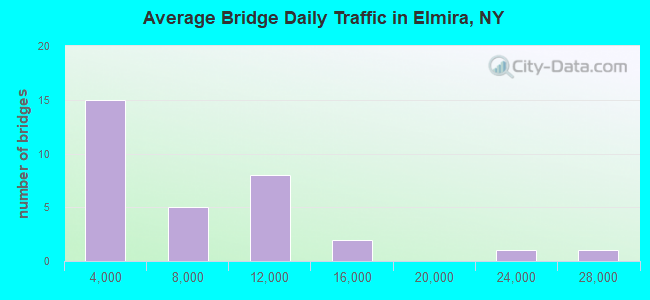
- 197,749Total average daily traffic
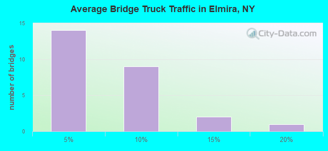
- 9,809Total average daily truck traffic
- National Bridge Inventory (NBI) Registered Bridges for Elmira
- No street view available for this location
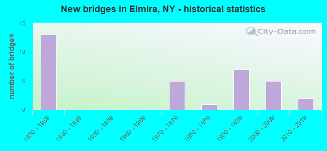
- New bridges - historical statistics
- 131930-1939
- 51970-1979
- 11980-1989
- 71990-1999
- 52000-2009
- 22010-2019
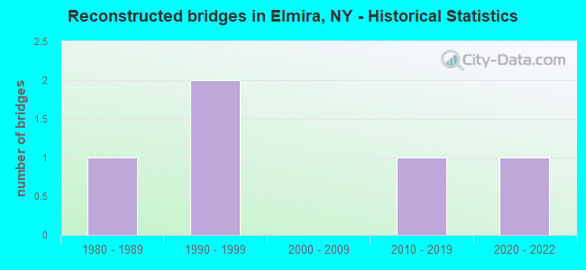
- Reconstructed bridges - Historical Statistics
- 11980-1989
- 21990-1999
- 02000-2009
- 12010-2019
- 12020-2022
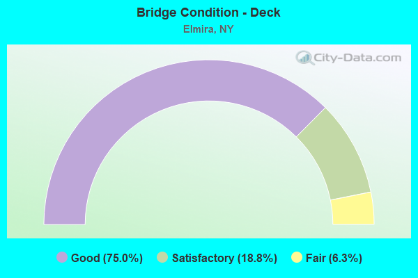
- Bridge Condition - Deck
- 75.0%Good
- 18.8%Satisfactory
- 6.3%Fair
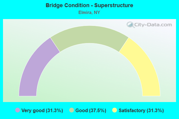
- Bridge Condition - Superstructure
- 31.3%Very good
- 37.5%Good
- 31.3%Satisfactory
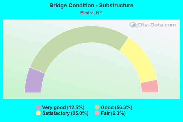
- Bridge Condition - Substructure
- 12.5%Very good
- 56.3%Good
- 25.0%Satisfactory
- 6.3%Fair
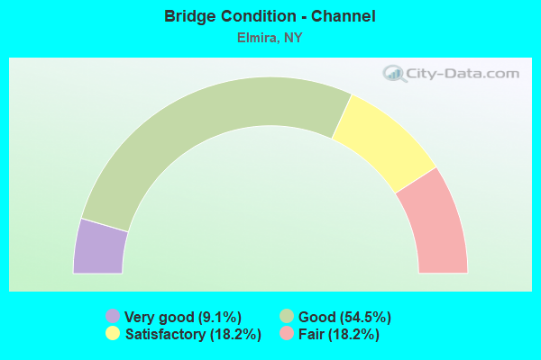
- Bridge Condition - Channel
- 9.1%Very good
- 54.5%Good
- 18.2%Satisfactory
- 18.2%Fair
Find on map >> Show street view
Structure Number: 1010769, Location: .3 MI W JCT SR 17 & SR352 (Lat: 42.095708, Lng: -76.787925), Route carried "on" structure: State highway 352, Year Built: 2002, Status: Open, Structure Length: 5.36m (17.59ft), Average Daily Traffic: 9,026 (year 2020), Truck Traffic: 4%, Average Future Daily Traffic: 9,068 (year 2040), Design Load: HS 25 or greater, Features Intersected: NEWTOWN CREEK
Minimum Vertical Clearance: 30+ m (98+ ft), Kilometerpoint: 18.857, Lanes on structure: 4, Base Highway Network: Yes, Owner: State Highway Agency, Approaching Roadway Width: 15.9m (52.2ft), Skew: 1 degrees, Material/Design: Steel continuous, Design/Construction: Stringer/Multi-beam, Number Of Spans In Main Unit: 2, Length of Maximum Span: 33.2m (108.9ft), Curb-To-Curb Width: 15.9m (52.2ft), Out-to-Out Width: 16.8m (55.1ft)
Condition: Deck: Satisfactory, Superstructure: Good, Substructure: Good, Channel: Good, Operating Rating: 77.1 metric tons, Method Used To Determine Operating Rating: Load Factor (LF), Inventory Rating: 45.4 metric tons, Method Used To Determine Inventory Rating: Load Factor (LF), Structural Evaluation: Better than present minimum criteria, Deck Geometry: Meets minimum limits, Waterway Adequacy: Equal to present minimum criteria, Approach Roadway Alignment: Equal to present desirable criteria, Length Of Structure Improvement: 5.36m (17.59ft), Designated Inspection Frequency: Every 24 months, Inspection Date: July 2020, Bridge Improvement Cost: $2,291,000, Roadway Improvement Cost: $1,342,000, Total Project Cost: $3,633,000 ( Estimate for 2021), Deck Structure Type: Concrete Cast-file-Place, Wearing Surface/Protective System: Wearing Surface: Integral Concrete, Deck Protection: Epoxy Coated Reinforcing
Find on map >> Show street view
Structure Number: 1010779, Location: JCT SR 17 & SR 352 (Lat: 42.095978, Lng: -76.786553), Route carried "on" structure: State highway 352, Year Built: 2002, Status: Open, Structure Length: 5.15m (16.90ft), Average Daily Traffic: 9,026 (year 2020), Truck Traffic: 4%, Average Future Daily Traffic: 9,068 (year 2040), Design Load: HS 25 or greater, Features Intersected: 86I 14 62013000, RTE I8
Minimum Vertical Clearance: 30+ m (98+ ft), Kilometerpoint: 18.970, Lanes on structure: 2, Lanes under structure: 4, Base Highway Network: Yes, Owner: State Highway Agency, Approaching Roadway Width: 11.3m (37.1ft), Skew: 1 degrees, Material/Design: Steel continuous, Design/Construction: Stringer/Multi-beam, Number Of Spans In Main Unit: 2, Length of Maximum Span: 25.0m (82.0ft), Curb-To-Curb Width: 11.4m (37.4ft), Out-to-Out Width: 12.3m (40.4ft)
Condition: Deck: Good, Superstructure: Good, Substructure: Good, Operating Rating: 75.3 metric tons, Method Used To Determine Operating Rating: Load Factor (LF), Inventory Rating: 45.4 metric tons, Method Used To Determine Inventory Rating: Load Factor (LF), Structural Evaluation: Better than present minimum criteria, Deck Geometry: Meets minimum limits, Underclear: Meets minimum limits, Approach Roadway Alignment: Equal to present desirable criteria, Length Of Structure Improvement: 5.15m (16.90ft), Designated Inspection Frequency: Every 24 months, Inspection Date: August 2020, Bridge Improvement Cost: $2,020,000, Roadway Improvement Cost: $1,183,000, Total Project Cost: $3,202,000 ( Estimate for 2021), Deck Structure Type: Concrete Cast-file-Place, Wearing Surface/Protective System: Wearing Surface: Monolithic Concrete, Deck Protection: Epoxy Coated Reinforcing
Find on map >> Show street view
Structure Number: 101079, Location: .4 mi NW JCT I86/Rte 352 (Lat: 42.100808, Lng: -76.790958), Route carried "on" structure: County highway , Year Built: 2018, Status: Open, Structure Length: 6.46m (21.19ft), Average Daily Traffic: 1,128 (year 2020), Truck Traffic: 3%, Average Future Daily Traffic: 1,395 (year 2040), Design Load: HL 93, Features Intersected: 86I 14 62013004, RTE 86, Facility Carried by Structure: EAST AVENUE
Minimum Vertical Clearance: 32.69m (107.25ft), Kilometerpoint: 0.499, Lanes on structure: 2, Lanes under structure: 4, Owner: State Highway Agency, Approaching Roadway Width: 10.7m (35.1ft), Material/Design: Steel continuous, Design/Construction: Stringer/Multi-beam, Number Of Spans In Main Unit: 2, Length of Maximum Span: 32.0m (105.0ft), Curb-To-Curb Width: 9.1m (29.9ft), Out-to-Out Width: 10.1m (33.1ft)
Condition: Deck: Good, Superstructure: Very good, Substructure: Very good, Operating Rating: 67.1 metric tons, Method Used To Determine Operating Rating: Load Factor (LF), Inventory Rating: 39.9 metric tons, Method Used To Determine Inventory Rating: Load Factor (LF), Structural Evaluation: Equal to present desirable criteria, Deck Geometry: Somewhat better than minimum adequacy, Underclear: High priority of corrective action, Approach Roadway Alignment: Equal to present desirable criteria, Length Of Structure Improvement: 6.46m (21.19ft), Designated Inspection Frequency: Every 24 months, Inspection Date: November 2020, Bridge Improvement Cost: $1,601,000, Roadway Improvement Cost: $937,000, Total Project Cost: $2,538,000 ( Estimate for 2021), Deck Structure Type: Concrete Cast-file-Place, Wearing Surface/Protective System: Wearing Surface: Integral Concrete, Deck Protection: Epoxy Coated Reinforcing
Find on map >> Show street view
Structure Number: 1012809, Location: .5 MI SE JCT SR17& SR352 (Lat: 42.090472, Lng: -76.782481), Route carried "on" structure: City street 86, Year Built: 2002, Status: Open, Structure Length: 6.22m (20.41ft), Average Daily Traffic: 8,672 (year 2020), Truck Traffic: 7%, Average Future Daily Traffic: 8,712 (year 2040), Design Load: HS 25 or greater, Features Intersected: 86I 17 62051130, RTE 86I
Minimum Vertical Clearance: 30+ m (98+ ft), Kilometerpoint: 1.850, Lanes on structure: 2, Lanes under structure: 4, Base Highway Network: Yes, Owner: State Highway Agency, Approaching Roadway Width: 11.3m (37.1ft), Skew: 2 degrees, Material/Design: Steel continuous, Design/Construction: Stringer/Multi-beam, Number Of Spans In Main Unit: 2, Length of Maximum Span: 34.1m (111.9ft), Curb-To-Curb Width: 11.4m (37.4ft), Out-to-Out Width: 12.3m (40.4ft)
Condition: Deck: Good, Superstructure: Good, Substructure: Satisfactory, Operating Rating: 83.5 metric tons, Method Used To Determine Operating Rating: Load Factor (LF), Inventory Rating: 42.6 metric tons, Method Used To Determine Inventory Rating: Load Factor (LF), Structural Evaluation: Equal to present minimum criteria, Deck Geometry: Meets minimum limits, Underclear: High priority of corrective action, Approach Roadway Alignment: Equal to present desirable criteria, Length Of Structure Improvement: 6.21m (20.37ft), Designated Inspection Frequency: Every 24 months, Inspection Date: August 2020, Bridge Improvement Cost: $2,234,000, Roadway Improvement Cost: $1,308,000, Total Project Cost: $3,541,000 ( Estimate for 2021), Deck Structure Type: Concrete Cast-file-Place, Wearing Surface/Protective System: Wearing Surface: Monolithic Concrete, Deck Protection: Epoxy Coated Reinforcing
Find on map >> Show street view
Structure Number: 1071189, Location: ELMIRA PENNAVE-NASHAVE (Lat: 42.086103, Lng: -76.803183), Route carried "on" structure: State highway 14, Year Built: 1979, Year Reconstructed: 2017, Status: Open, Structure Length: 24.32m (79.79ft), Average Daily Traffic: 9,639 (year 2018), Truck Traffic: 8%, Average Future Daily Traffic: 9,684 (year 2040), Design Load: HS 20, Features Intersected: CHEMUNG RIVER
Minimum Vertical Clearance: 30+ m (98+ ft), Kilometerpoint: 11.697, Lanes on structure: 4, Base Highway Network: Yes, Owner: State Highway Agency, Approaching Roadway Width: 22.3m (73.2ft), Skew: 30 degrees, Material/Design: Steel continuous, Design/Construction: Stringer/Multi-beam, Number Of Spans In Main Unit: 8, Length of Maximum Span: 46.3m (151.9ft), Curb-To-Curb Width: 19.8m (65.0ft), Out-to-Out Width: 20.5m (67.3ft)
Condition: Deck: Satisfactory, Superstructure: Satisfactory, Substructure: Good, Channel: Satisfactory, Operating Rating: 22.0 metric tons, Method Used To Determine Operating Rating: Load and Resistance Factor Rating (LRFR) rating reported by rating factor(RF) method using HL-93 loadings, Inventory Rating: 16.8 metric tons, Method Used To Determine Inventory Rating: Load and Resistance Factor Rating (LRFR) rating reported by rating factor(RF) method using HL-93 loadings, Structural Evaluation: Meets minimum limits, Deck Geometry: Better than present minimum criteria, Waterway Adequacy: Somewhat better than minimum adequacy, Approach Roadway Alignment: Equal to present desirable criteria, Length Of Structure Improvement: 24.32m (79.79ft), Designated Inspection Frequency: Every 24 months, Inspection Date: October 2020, Bridge Improvement Cost: $11,723,000, Roadway Improvement Cost: $6,865,000, Total Project Cost: $18,587,000 ( Estimate for 2021), Deck Structure Type: Concrete Cast-file-Place, Wearing Surface/Protective System: Wearing Surface: Epoxy Overlay, Deck Protection: Epoxy Coated Reinforcing
Find on map >> Show street view
Structure Number: 107749, Location: ELMIRA N-S ART /S MAIN ST (Lat: 42.073431, Lng: -76.800492), Route carried "on" structure: ServiceState highway 14, Year Built: 1999, Status: Open, Structure Length: 2.99m (9.81ft), Average Daily Traffic: 9,678 (year 2020), Truck Traffic: 7%, Average Future Daily Traffic: 9,723 (year 2040), Design Load: HS 25 or greater, Features Intersected: SOUTH MAIN STREET
Minimum Vertical Clearance: 30+ m (98+ ft), Kilometerpoint: 10.201, Lanes on structure: 4, Lanes under structure: 2, Base Highway Network: Yes, Owner: State Highway Agency, Approaching Roadway Width: 17.7m (58.1ft), Skew: 33 degrees, Material/Design: Steel, Design/Construction: Stringer/Multi-beam, Number Of Spans In Main Unit: 1, Length of Maximum Span: 28.9m (94.8ft), Curb-To-Curb Width: 17.7m (58.1ft), Out-to-Out Width: 23.5m (77.1ft)
Condition: Deck: Good, Superstructure: Very good, Substructure: Very good, Operating Rating: 78.0 metric tons, Method Used To Determine Operating Rating: Load Factor (LF), Inventory Rating: 46.3 metric tons, Method Used To Determine Inventory Rating: Load Factor (LF), Structural Evaluation: Equal to present desirable criteria, Deck Geometry: Somewhat better than minimum adequacy, Underclear: High priority of corrective action, Approach Roadway Alignment: Equal to present desirable criteria, Length Of Structure Improvement: 2.98m (9.78ft), Designated Inspection Frequency: Every 24 months, Inspection Date: April 2021, Bridge Improvement Cost: $2,258,000, Roadway Improvement Cost: $1,322,000, Total Project Cost: $3,580,000 ( Estimate for 2021), Deck Structure Type: Concrete Cast-file-Place, Wearing Surface/Protective System: Wearing Surface: Integral Concrete, Deck Protection: Epoxy Coated Reinforcing
Find on map >> Show street view
Structure Number: 221554, Location: IN CITY OF ELMIRA (Lat: 42.087053, Lng: -76.806831), Route carried "on" structure: City street , Year Built: 1976, Status: Open, Structure Length: 22.71m (74.51ft), Average Daily Traffic: 6,966 (year 2016), Truck Traffic: 3%, Average Future Daily Traffic: 8,462 (year 2040), Design Load: HS 20, Features Intersected: CHEMUNG RIVER, Facility Carried by Structure: MAIN ST
Minimum Vertical Clearance: 30+ m (98+ ft), Kilometerpoint: 0.000, Lanes on structure: 2, Owner: City or Municipal Highway Agency, Approaching Roadway Width: 10.4m (34.1ft), Material/Design: Steel, Design/Construction: Stringer/Multi-beam, Number Of Spans In Main Unit: 5, Length of Maximum Span: 57.9m (190.0ft), Curb or Sidewalk Widths: Left: 2.4m (7.9ft), Right: 2.4m (7.9ft), Curb-To-Curb Width: 10.4m (34.1ft), Out-to-Out Width: 16.0m (52.5ft)
Condition: Deck: Fair, Superstructure: Satisfactory, Substructure: Satisfactory, Channel: Good, Operating Rating: 89.8 metric tons, Method Used To Determine Operating Rating: Load Factor (LF), Inventory Rating: 49.0 metric tons, Method Used To Determine Inventory Rating: Load Factor (LF), Structural Evaluation: Equal to present minimum criteria, Deck Geometry: Meets minimum limits, Waterway Adequacy: Superior to present desirable criteria, Approach Roadway Alignment: Equal to present desirable criteria, Length Of Structure Improvement: 22.70m (74.48ft), Designated Inspection Frequency: Every 24 months, Inspection Date: June 2021, Bridge Improvement Cost: $9,490,000, Roadway Improvement Cost: $5,557,000, Total Project Cost: $15,047,000 ( Estimate for 2021), Deck Structure Type: Concrete Cast-file-Place, Wearing Surface/Protective System: Wearing Surface: Integral Concrete
Find on map >> Show street view
Structure Number: 221556, Location: IN CITY OF ELMIRA (Lat: 42.099253, Lng: -76.794847), Route carried "on" structure: City street , Year Built: 1992, Status: Open, Structure Length: 2.87m (9.42ft), Average Daily Traffic: 1,128 (year 2020), Truck Traffic: 3%, Average Future Daily Traffic: 1,395 (year 2040), Design Load: HS 20, Features Intersected: NEWTOWN CREEK, Facility Carried by Structure: EAST AVENUE
Minimum Vertical Clearance: 30+ m (98+ ft), Kilometerpoint: 0.145, Lanes on structure: 2, Owner: City or Municipal Highway Agency, Approaching Roadway Width: 7.3m (24.0ft), Material/Design: Prestressed concrete, Design/Construction: Box Beam or Girders - Multiple, Number Of Spans In Main Unit: 1, Length of Maximum Span: 28.0m (91.9ft), Curb or Sidewalk Widths: Left: 1.5m (4.9ft), Right: 1.5m (4.9ft), Curb-To-Curb Width: 7.3m (24.0ft), Out-to-Out Width: 11.0m (36.1ft)
Condition: Deck: Good, Superstructure: Good, Substructure: Good, Channel: Good, Operating Rating: 74.4 metric tons, Method Used To Determine Operating Rating: Load Factor (LF), Inventory Rating: 32.7 metric tons, Method Used To Determine Inventory Rating: Load Factor (LF), Structural Evaluation: Better than present minimum criteria, Deck Geometry: Meets minimum limits, Waterway Adequacy: Somewhat better than minimum adequacy, Approach Roadway Alignment: Equal to present desirable criteria, Length Of Structure Improvement: 2.86m (9.38ft), Designated Inspection Frequency: Every 24 months, Inspection Date: March 2021, Bridge Improvement Cost: $924,000, Roadway Improvement Cost: $541,000, Total Project Cost: $1,465,000 ( Estimate for 2021), Deck Structure Type: Other, Wearing Surface/Protective System: Wearing Surface: Monolithic Concrete
Find on map >> Show street view
Structure Number: 221557, Location: IN CITY OF ELMIRA (Lat: 42.104697, Lng: -76.798250), Route carried "on" structure: Business City street , Year Built: 1992, Status: Open, Structure Length: 2.56m (8.40ft), Average Daily Traffic: 736 (year 2018), Truck Traffic: 18%, Average Future Daily Traffic: 1,030 (year 2038), Design Load: HS 20, Features Intersected: NEWTOWN CREEK, Facility Carried by Structure: LINDEN PLACE
Minimum Vertical Clearance: 30+ m (98+ ft), Kilometerpoint: 0.531, Lanes on structure: 2, Owner: City or Municipal Highway Agency, Approaching Roadway Width: 9.8m (32.2ft), Material/Design: Prestressed concrete, Design/Construction: Box Beam or Girders - Multiple, Number Of Spans In Main Unit: 1, Length of Maximum Span: 25.2m (82.7ft), Curb-To-Curb Width: 10.0m (32.8ft), Out-to-Out Width: 10.2m (33.5ft)
Condition: Deck: Good, Superstructure: Good, Substructure: Good, Channel: Good, Operating Rating: 65.8 metric tons, Method Used To Determine Operating Rating: Load and Resistance Factor Rating (LRFR) rating reported by rating factor(RF) method using HL-93 loadings, Inventory Rating: 50.5 metric tons, Method Used To Determine Inventory Rating: Load and Resistance Factor Rating (LRFR) rating reported by rating factor(RF) method using HL-93 loadings, Structural Evaluation: Better than present minimum criteria, Deck Geometry: Equal to present minimum criteria, Waterway Adequacy: Meets minimum limits, Approach Roadway Alignment: Equal to present desirable criteria, Length Of Structure Improvement: 2.56m (8.40ft), Designated Inspection Frequency: Every 24 months, Inspection Date: March 2021, Bridge Improvement Cost: $890,000, Roadway Improvement Cost: $521,000, Total Project Cost: $1,411,000 ( Estimate for 2021), Wearing Surface/Protective System: Wearing Surface: Bituminous, Membrane: Other
Find on map >> Show street view
Structure Number: 221567, Location: IN CITY OF ELMIRA (Lat: 42.099742, Lng: -76.811406), Route carried "on" structure: City street , Year Built: 1988, Status: Open, Structure Length: 5.52m (18.11ft), Average Daily Traffic: 6,214 (year 2020), Truck Traffic: 3%, Average Future Daily Traffic: 7,548 (year 2040), Design Load: HS 20, Features Intersected: NORFOLK SOUTHERN, Facility Carried by Structure: WASHINGTON AVE
Minimum Vertical Clearance: 30+ m (98+ ft), Kilometerpoint: 1.448, Lanes on structure: 2, Owner: City or Municipal Highway Agency, Approaching Roadway Width: 8.5m (27.9ft), Material/Design: Steel continuous, Design/Construction: Stringer/Multi-beam, Number Of Spans In Main Unit: 3, Length of Maximum Span: 28.3m (92.8ft), Curb or Sidewalk Widths: Left: 1.5m (4.9ft), Right: 1.5m (4.9ft), Curb-To-Curb Width: 8.5m (27.9ft), Out-to-Out Width: 12.1m (39.7ft)
Condition: Deck: Good, Superstructure: Very good, Substructure: Satisfactory, Operating Rating: 65.3 metric tons, Method Used To Determine Operating Rating: Load Factor (LF), Inventory Rating: 32.7 metric tons, Method Used To Determine Inventory Rating: Load Factor (LF), Structural Evaluation: Equal to present minimum criteria, Deck Geometry: High priority of replacement, Underclear: Somewhat better than minimum adequacy, Approach Roadway Alignment: Equal to present desirable criteria, Length Of Structure Improvement: 5.51m (18.08ft), Designated Inspection Frequency: Every 24 months, Inspection Date: September 2020, Bridge Improvement Cost: $1,817,000, Roadway Improvement Cost: $1,064,000, Total Project Cost: $2,881,000 ( Estimate for 2021), Deck Structure Type: Concrete Cast-file-Place, Wearing Surface/Protective System: Wearing Surface: Integral Concrete, Deck Protection: Epoxy Coated Reinforcing
Find on map >> Show street view
Structure Number: 221575, Location: IN THE CITY OF ELMIRA (Lat: 42.090367, Lng: -76.784350), Route carried "on" structure: City street , Year Built: 1990, Status: Open, Structure Length: 12.13m (39.80ft), Average Daily Traffic: 8,672 (year 2020), Truck Traffic: 7%, Average Future Daily Traffic: 8,712 (year 2040), Design Load: HS 20, Features Intersected: NEWTOWN CREEK, EX-D.L.&, Facility Carried by Structure: WATER STREET
Minimum Vertical Clearance: 30+ m (98+ ft), Kilometerpoint: 1.673, Lanes on structure: 2, Owner: State Highway Agency, Approaching Roadway Width: 11.9m (39.0ft), Skew: 1 degrees, Material/Design: Steel, Design/Construction: Stringer/Multi-beam, Number Of Spans In Main Unit: 4, Length of Maximum Span: 38.1m (125.0ft), Curb-To-Curb Width: 12.2m (40.0ft), Out-to-Out Width: 13.0m (42.7ft)
Condition: Deck: Good, Superstructure: Satisfactory, Substructure: Good, Channel: Very good, Operating Rating: 73.5 metric tons, Method Used To Determine Operating Rating: Load Factor (LF), Inventory Rating: 34.5 metric tons, Method Used To Determine Inventory Rating: Load Factor (LF), Structural Evaluation: Equal to present minimum criteria, Deck Geometry: Somewhat better than minimum adequacy, Waterway Adequacy: Equal to present desirable criteria, Approach Roadway Alignment: Equal to present desirable criteria, Length Of Structure Improvement: 12.13m (39.80ft), Designated Inspection Frequency: Every 24 months, Inspection Date: May 2020, Bridge Improvement Cost: $4,831,000, Roadway Improvement Cost: $2,829,000, Total Project Cost: $7,660,000 ( Estimate for 2021), Deck Structure Type: Concrete Cast-file-Place, Wearing Surface/Protective System: Wearing Surface: Integral Concrete, Deck Protection: Epoxy Coated Reinforcing
Find on map >> Show street view
Structure Number: 221581, Location: IN CITY OF ELMIRA (Lat: 42.088139, Lng: -76.797956), Route carried "on" structure: City street , Year Built: 1938, Year Reconstructed: 1988, Status: Open, Structure Length: 16.92m (55.51ft), Average Daily Traffic: 14,723 (year 2020), Truck Traffic: 3%, Average Future Daily Traffic: 17,885 (year 2040), Design Load: HS 20, Features Intersected: CHEMUNG RIVER, Facility Carried by Structure: MADISON AVENUE
Minimum Vertical Clearance: 30+ m (98+ ft), Kilometerpoint: 0.032, Lanes on structure: 3, Owner: City or Municipal Highway Agency, Approaching Roadway Width: 12.8m (42.0ft), Material/Design: Steel continuous, Design/Construction: Stringer/Multi-beam, Number Of Spans In Main Unit: 7, Length of Maximum Span: 34.1m (111.9ft), Curb or Sidewalk Widths: Left: 1.8m (5.9ft), Right: 1.8m (5.9ft), Curb-To-Curb Width: 12.8m (42.0ft), Out-to-Out Width: 16.5m (54.1ft)
Condition: Deck: Good, Superstructure: Very good, Substructure: Good, Channel: Good, Operating Rating: 76.2 metric tons, Method Used To Determine Operating Rating: Load Factor (LF), Inventory Rating: 45.4 metric tons, Method Used To Determine Inventory Rating: Load Factor (LF), Structural Evaluation: Better than present minimum criteria, Deck Geometry: Meets minimum limits, Waterway Adequacy: Equal to present desirable criteria, Approach Roadway Alignment: Equal to present desirable criteria, Length Of Structure Improvement: 16.91m (55.48ft), Designated Inspection Frequency: Every 24 months, Inspection Date: October 2021, Bridge Improvement Cost: $7,324,000, Roadway Improvement Cost: $4,289,000, Total Project Cost: $11,612,000 ( Estimate for 2021), Deck Structure Type: Concrete Cast-file-Place, Wearing Surface/Protective System: Wearing Surface: Integral Concrete, Deck Protection: Epoxy Coated Reinforcing
Find on map >> Show street view
Structure Number: 225451, Location: IN CITY OF ELMIRA (Lat: 42.083872, Lng: -76.815633), Route carried "on" structure: City street , Year Built: 1974, Year Reconstructed: 2020, Status: Open, Structure Length: 29.84m (97.90ft), Average Daily Traffic: 10,280 (year 2017), Truck Traffic: 2%, Average Future Daily Traffic: 12,488 (year 2040), Design Load: HS 20, Features Intersected: CHEMUNG RIVER, Facility Carried by Structure: WALNUT STREET
Minimum Vertical Clearance: 30+ m (98+ ft), Kilometerpoint: 0.000, Lanes on structure: 4, Owner: City or Municipal Highway Agency, Approaching Roadway Width: 14.6m (47.9ft), Skew: 1 degrees, Material/Design: Steel continuous, Design/Construction: Stringer/Multi-beam, Number Of Spans In Main Unit: 7, Length of Maximum Span: 54.9m (180.1ft), Curb or Sidewalk Widths: Left: 1.8m (5.9ft), Right: 0.5m (1.6ft), Curb-To-Curb Width: 14.6m (47.9ft), Out-to-Out Width: 17.7m (58.1ft)
Condition: Deck: Good, Superstructure: Satisfactory, Substructure: Good, Channel: Satisfactory, Operating Rating: 53.5 metric tons, Method Used To Determine Operating Rating: Load Factor (LF), Inventory Rating: 32.7 metric tons, Method Used To Determine Inventory Rating: Load Factor (LF), Structural Evaluation: Equal to present minimum criteria, Deck Geometry: High priority of replacement, Waterway Adequacy: Somewhat better than minimum adequacy, Approach Roadway Alignment: Equal to present desirable criteria, Length Of Structure Improvement: 29.83m (97.87ft), Designated Inspection Frequency: Every 24 months, Underwater Inspection Frequency: Every 60 months, Inspection Date: December 2020, Underwater Inspection Date: September 2020, Bridge Improvement Cost: $12,500,000, Roadway Improvement Cost: $7,320,000, Total Project Cost: $19,820,000 ( Estimate for 2021), Deck Structure Type: Concrete Cast-file-Place, Wearing Surface/Protective System: Wearing Surface: Monolithic Concrete
Find on map >> Show street view
Structure Number: 225452, Location: IN CITY OF ELMIRA (Lat: 42.112531, Lng: -76.801367), Route carried "on" structure: City street , Year Built: 1974, Status: Open, Structure Length: 1.83m (6.00ft), Average Daily Traffic: 283 (year 2018), Truck Traffic: 3%, Average Future Daily Traffic: 396 (year 2038), Design Load: HS 20, Features Intersected: NEWTOWN CREEK, Facility Carried by Structure: INDUSTRIAL PK.BLV
Minimum Vertical Clearance: 30+ m (98+ ft), Kilometerpoint: 1.786, Lanes on structure: 2, Owner: City or Municipal Highway Agency, Approaching Roadway Width: 9.1m (29.9ft), Material/Design: Prestressed concrete, Design/Construction: Box Beam or Girders - Multiple, Number Of Spans In Main Unit: 1, Length of Maximum Span: 17.6m (57.7ft), Curb or Sidewalk Widths: Left: 1.8m (5.9ft), Right: 1.8m (5.9ft), Curb-To-Curb Width: 9.1m (29.9ft), Out-to-Out Width: 13.6m (44.6ft)
Condition: Deck: Satisfactory, Superstructure: Satisfactory, Substructure: Good, Channel: Good, Operating Rating: 54.4 metric tons, Method Used To Determine Operating Rating: Load Factor (LF), Inventory Rating: 32.7 metric tons, Method Used To Determine Inventory Rating: Load Factor (LF), Structural Evaluation: Equal to present minimum criteria, Deck Geometry: Equal to present minimum criteria, Waterway Adequacy: Equal to present desirable criteria, Approach Roadway Alignment: Equal to present desirable criteria, Length Of Structure Improvement: 1.82m (5.97ft), Designated Inspection Frequency: Every 24 months, Inspection Date: May 2020, Bridge Improvement Cost: $1,166,000, Roadway Improvement Cost: $683,000, Total Project Cost: $1,848,000 ( Estimate for 2021), Wearing Surface/Protective System: Wearing Surface: Bituminous, Membrane: Preformed Fabric
Find on map >> Show street view
Structure Number: 333177, Location: 2.5 MI E OF ELMIRA (Lat: 42.096639, Lng: -76.757036), Route carried "on" structure: Other road , Year Built: 1933, Year Reconstructed: 1999, Status: Open, Structure Length: 1.31m (4.30ft), Average Daily Traffic: 316 (year 2018), Truck Traffic: 5%, Average Future Daily Traffic: 442 (year 2038), Design Load: HS 25 or greater, Features Intersected: GOLDSMITH CREEK, Facility Carried by Structure: DRAHT HILL ROAD
Minimum Vertical Clearance: 30+ m (98+ ft), Kilometerpoint: 1.529, Lanes on structure: 2, Owner: County Highway Agency, Approaching Roadway Width: 5.8m (19.0ft), Skew: 1 degrees, Material/Design: Wood or Timber, Design/Construction: Stringer/Multi-beam, Number Of Spans In Main Unit: 1, Length of Maximum Span: 12.8m (42.0ft), Curb-To-Curb Width: 7.3m (24.0ft), Out-to-Out Width: 7.9m (25.9ft)
Condition: Deck: Good, Superstructure: Very good, Substructure: Fair, Channel: Fair, Operating Rating: 81.6 metric tons, Method Used To Determine Operating Rating: Field evaluation and documented engineering judgment, Inventory Rating: 40.8 metric tons, Method Used To Determine Inventory Rating: Field evaluation and documented engineering judgment, Structural Evaluation: Somewhat better than minimum adequacy, Deck Geometry: Somewhat better than minimum adequacy, Waterway Adequacy: Meets minimum limits, Approach Roadway Alignment: Better than present minimum criteria, Length Of Structure Improvement: 1.31m (4.30ft), Designated Inspection Frequency: Every 24 months, Inspection Date: May 2021, Bridge Improvement Cost: $382,000, Roadway Improvement Cost: $223,000, Total Project Cost: $605,000 ( Estimate for 2021), Deck Structure Type: Wood or Timber, Wearing Surface/Protective System: Wearing Surface: Bituminous, Membrane: Other
Find on map >> Show street view
Structure Number: 333178, Location: 2.7 MI E OF ELMIRA (Lat: 42.103644, Lng: -76.755708), Route carried "on" structure: Other road , Year Built: 1976, Year Reconstructed: 1999, Status: Open, Structure Length: 0.91m (2.99ft), Average Daily Traffic: 114 (year 2016), Truck Traffic: 5%, Average Future Daily Traffic: 160 (year 2036), Design Load: HS 25 or greater, Features Intersected: GOLDSMITH CREEK, Facility Carried by Structure: MONKEY RUN ROAD
Minimum Vertical Clearance: 30+ m (98+ ft), Kilometerpoint: 2.574, Lanes on structure: 2, Owner: County Highway Agency, Approaching Roadway Width: 5.8m (19.0ft), Skew: 2 degrees, Material/Design: Wood or Timber, Design/Construction: Stringer/Multi-beam, Number Of Spans In Main Unit: 1, Length of Maximum Span: 8.5m (27.9ft), Curb-To-Curb Width: 7.3m (24.0ft), Out-to-Out Width: 7.9m (25.9ft)
Condition: Deck: Good, Superstructure: Good, Substructure: Satisfactory, Channel: Fair, Operating Rating: 78.7 metric tons, Method Used To Determine Operating Rating: Field evaluation and documented engineering judgment, Inventory Rating: 40.8 metric tons, Method Used To Determine Inventory Rating: Field evaluation and documented engineering judgment, Structural Evaluation: Equal to present minimum criteria, Deck Geometry: Somewhat better than minimum adequacy, Waterway Adequacy: Superior to present desirable criteria, Approach Roadway Alignment: Equal to present desirable criteria, Length Of Structure Improvement: 0.91m (2.99ft), Designated Inspection Frequency: Every 24 months, Inspection Date: March 2021, Bridge Improvement Cost: $312,000, Roadway Improvement Cost: $183,000, Total Project Cost: $495,000 ( Estimate for 2021), Deck Structure Type: Wood or Timber, Wearing Surface/Protective System: Wearing Surface: Bituminous, Membrane: Other
Find on map >> Show street view
Structure Number: 1010779, Location: JCT SR 17 & SR 352 (Lat: 42.095978, Lng: -76.786553), Route carried "under" structure: Interstate 86, Year Built: 2002, Structure Length: 0. m, Average Daily Traffic: 13,000 (year 1969), Features Intersected: 86I 14 62013000, RTE I8, Facility Carried by Structure: RTE 352
Minimum Vertical Clearance: 5.28m (17.32ft), Kilometerpoint: 4.216, Lanes on structure: 2, Lanes under structure: 2, Material/Design: Steel continuous, Design/Construction: Stringer/Multi-beam, Length of Maximum Span: 25.0m (82.0ft)
Find on map >> Show street view
Structure Number: 101079, Location: .4 mi NW JCT I86/Rte 352 (Lat: 42.100808, Lng: -76.790958), Route carried "under" structure: Interstate 86, Year Built: 2018, Structure Length: 0. m, Average Daily Traffic: 27,500 (year 2018), Truck Traffic: 14%, Features Intersected: 86I 14 62013004, RTE 86, Facility Carried by Structure: EAST AVENUE
Minimum Vertical Clearance: 5.64m (18.50ft), Kilometerpoint: 19.710, Lanes on structure: 2, Lanes under structure: 2, Material/Design: Steel continuous, Design/Construction: Stringer/Multi-beam, Length of Maximum Span: 32.0m (105.0ft)
Find on map >> Show street view
Structure Number: 1012809, Location: .5 MI SE JCT SR17& SR352 (Lat: 42.090472, Lng: -76.782481), Route carried "under" structure: Interstate 86, Year Built: 2002, Structure Length: 0. m, Average Daily Traffic: 21,600 (year 1998), Features Intersected: 86I 17 62051130, RTE 86I
Minimum Vertical Clearance: 5.08m (16.67ft), Kilometerpoint: 32.470, Lanes on structure: 2, Lanes under structure: 2, Material/Design: Steel continuous, Design/Construction: Stringer/Multi-beam, Length of Maximum Span: 34.1m (111.9ft)
Find on map >> Show street view
Structure Number: 107749, Location: ELMIRA N-S ART /S MAIN ST (Lat: 42.073431, Lng: -76.800492), Route carried "under" structure: ServiceCity street , Year Built: 1999, Structure Length: 0. m, Average Daily Traffic: 5,250 (year 2019), Truck Traffic: 5%, Features Intersected: SOUTH MAIN STREET, Facility Carried by Structure: RTE 14
Minimum Vertical Clearance: 4.83m (15.85ft), Kilometerpoint: 0.354, Lanes on structure: 4, Lanes under structure: 2, Material/Design: Steel, Design/Construction: Stringer/Multi-beam, Length of Maximum Span: 28.9m (94.8ft)
Find on map >> Show street view
Structure Number: 721562, Location: IN CITY OF ELMIRA (Lat: 42.075208, Lng: -76.797986), Route carried "under" structure: City street , Year Built: 1934, Structure Length: 0. m, Average Daily Traffic: 50 (year 2021), Features Intersected: EAST MILLER ST, Facility Carried by Structure: NORFOLK SOUTHERN
Minimum Vertical Clearance: 4.55m (14.93ft), Kilometerpoint: 0.000, Lanes under structure: 2, Material/Design: Concrete, Design/Construction: Slab, Length of Maximum Span: 7.3m (24.0ft)
Find on map >> Show street view
Structure Number: 721563, Location: IN CITY OF ELMIRA (Lat: 42.076733, Lng: -76.798831), Route carried "under" structure: City street , Year Built: 1934, Structure Length: 0. m, Average Daily Traffic: 657 (year 2020), Truck Traffic: 1%, Features Intersected: SOUTH AVENUE, Facility Carried by Structure: NORFOLK SOUTHERN
Minimum Vertical Clearance: 4.19m (13.75ft), Kilometerpoint: 0.000, Lanes under structure: 2, Material/Design: Concrete, Design/Construction: Slab, Length of Maximum Span: 12.4m (40.7ft)
Find on map >> Show street view
Structure Number: 721565, Location: IN CITY OF ELMIRA (Lat: 42.083964, Lng: -76.802869), Route carried "under" structure: Other road , Year Built: 1934, Structure Length: 0. m, Average Daily Traffic: 3,099 (year 2019), Truck Traffic: 1%, Features Intersected: HUDSON ST, Facility Carried by Structure: NORFOLK SOUTHERN
Minimum Vertical Clearance: 3.89m (12.76ft), Kilometerpoint: 0.000, Material/Design: Concrete, Design/Construction: Slab, Length of Maximum Span: 7.3m (24.0ft)
Find on map >> Show street view
Structure Number: 721568, Location: IN CITY OF ELMIRA (Lat: 42.109800, Lng: -76.816683), Route carried "under" structure: State highway , Year Built: 1934, Structure Length: 0. m, Average Daily Traffic: 50 (year 2021), Features Intersected: WOODLAWN AVENUE, Facility Carried by Structure: NORFOLK SOUTHERN
Minimum Vertical Clearance: 4.52m (14.83ft), Kilometerpoint: 0.692, Lanes under structure: 2, Material/Design: Steel, Design/Construction: Girder and Floorbeam System, Length of Maximum Span: 10.0m (32.8ft)
Find on map >> Show street view
Structure Number: 72157, Location: IN CITY OF ELMIRA (Lat: 42.091994, Lng: -76.807297), Route carried "under" structure: City street , Year Built: 1934, Structure Length: 0. m, Average Daily Traffic: 20 (year 2021), Features Intersected: WEST CHURCH STREET, WEST, Facility Carried by Structure: NORFOLK SOUTHERN
Minimum Vertical Clearance: 3.96m (12.99ft), Kilometerpoint: 0.000, Lanes under structure: 2, Material/Design: Concrete, Design/Construction: Slab, Length of Maximum Span: 14.3m (46.9ft)
Find on map >> Show street view
Structure Number: 721571, Location: IN CITY OF ELMIRA (Lat: 42.100972, Lng: -76.807250), Route carried "under" structure: City street , Year Built: 1932, Structure Length: 0. m, Average Daily Traffic: 5,262 (year 2017), Truck Traffic: 4%, Features Intersected: WASHINGTON AVENUE, WASHI, Facility Carried by Structure: LACKAWANNA TRAIL
Minimum Vertical Clearance: 4.52m (14.83ft), Kilometerpoint: 0.274, Lanes under structure: 2, Material/Design: Concrete, Design/Construction: Slab, Length of Maximum Span: 9.7m (31.8ft)
Find on map >> Show street view
Structure Number: 721572, Location: IN CITY OF ELMIRA (Lat: 42.099628, Lng: -76.804442), Route carried "under" structure: City street , Year Built: 1933, Structure Length: 0. m, Average Daily Traffic: 543 (year 2019), Truck Traffic: 3%, Features Intersected: LAKE STREET, Facility Carried by Structure: LACKAWANNA TRAIL
Minimum Vertical Clearance: 4.06m (13.32ft), Kilometerpoint: 1.126, Lanes under structure: 2, Material/Design: Concrete, Design/Construction: Slab, Length of Maximum Span: 9.7m (31.8ft)
Find on map >> Show street view
Structure Number: 721573, Location: IN CITY OF ELMIRA (Lat: 42.099328, Lng: -76.803500), Route carried "under" structure: County highway 960Q, Year Built: 1933, Structure Length: 0. m, Average Daily Traffic: 3,945 (year 2019), Truck Traffic: 3%, Features Intersected: RTE 960Q, Facility Carried by Structure: LACKAWANNA TRAIL
Minimum Vertical Clearance: 4.06m (13.32ft), Kilometerpoint: 0.000, Lanes under structure: 4, Material/Design: Concrete continuous, Design/Construction: Slab, Length of Maximum Span: 10.3m (33.8ft)
Find on map >> Show street view
Structure Number: 721574, Location: IN CITY OF ELMIRA (Lat: 42.097808, Lng: -76.796022), Route carried "under" structure: City street , Year Built: 1932, Structure Length: 0. m, Average Daily Traffic: 3,062 (year 2020), Truck Traffic: 7%, Features Intersected: SULLIVAN STREET, Facility Carried by Structure: Lackawanna Trail
Minimum Vertical Clearance: 4.24m (13.91ft), Kilometerpoint: 0.000, Lanes under structure: 2, Material/Design: Concrete, Design/Construction: Slab, Length of Maximum Span: 10.6m (34.8ft)
Find on map >> Show street view
Structure Number: 72158, Location: IN CITY OF ELMIRA (Lat: 42.081769, Lng: -76.801650), Route carried "under" structure: City street , Year Built: 1934, Structure Length: 0. m, Average Daily Traffic: 5,160 (year 2019), Truck Traffic: 5%, Features Intersected: PENNSYLVANIA AVE, Facility Carried by Structure: NORFOLK SOUTHERN
Minimum Vertical Clearance: 4.50m (14.76ft), Kilometerpoint: 1.625, Lanes under structure: 2, Material/Design: Steel, Design/Construction: Girder and Floorbeam System, Length of Maximum Span: 18.8m (61.7ft)
Find on map >> Show street view
Structure Number: 77001, Location: IN ELMIRA (Lat: 42.096422, Lng: -76.809683), Route carried "under" structure: City street , Year Built: 1936, Structure Length: 0. m, Average Daily Traffic: 1,950 (year 2020), Truck Traffic: 10%, Features Intersected: SIDEWALK, FIFTH STREET, Facility Carried by Structure: NORFOLK SOUTHERN
Minimum Vertical Clearance: 3.91m (12.83ft), Kilometerpoint: 0.000, Lanes under structure: 2, Material/Design: Concrete, Design/Construction: Girder and Floorbeam System, Length of Maximum Span: 10.3m (33.8ft)
Find on map >> Show street view
Structure Number: 771523, Location: IN THE CITY OF ELMIRA (Lat: 42.079083, Lng: -76.800133), Route carried "under" structure: State highway , Year Built: 1997, Structure Length: 0. m, Features Intersected: ELMIRA ARTERIAL (SB), RT, Facility Carried by Structure: NORFOLK SOUTHERN
Minimum Vertical Clearance: 4.70m (15.42ft), Kilometerpoint: 10.941, Lanes under structure: 2, Material/Design: Steel continuous, Design/Construction: Girder and Floorbeam System, Length of Maximum Span: 27.1m (88.9ft)
Find on map >> Show street view
Structure Number: 771523, Location: IN THE CITY OF ELMIRA (Lat: 42.079083, Lng: -76.800133), Route carried "under" structure: State highway 14, Year Built: 1997, Structure Length: 0. m, Average Daily Traffic: 10,000 (year 1990), Features Intersected: ELMIRA ARTERIAL (SB), RT, Facility Carried by Structure: NORFOLK SOUTHERN
Minimum Vertical Clearance: 4.57m (14.99ft), Kilometerpoint: 10.941, Lanes under structure: 2, Material/Design: Steel continuous, Design/Construction: Girder and Floorbeam System, Length of Maximum Span: 27.1m (88.9ft)