Bridge Statistics for Elsinore, Utah (UT)
Condition, Traffic, Stress, Structural Evaluation, Project Costs
- National Bridge Inventory (NBI) Statistics
- 14Number of bridges
- 66ft / 19.6mTotal length
- 40,984Total average daily traffic
- 11,976Total average daily truck traffic
- National Bridge Inventory (NBI) Registered Bridges for Elsinore
- No street view available for this location
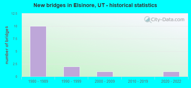
- New bridges - historical statistics
- 101980-1989
- 21990-1999
- 12000-2009
- 12020-2022


- Bridge Condition - Deck
- 16.7%Very good
- 16.7%Good
- 50.0%Satisfactory
- 16.7%Fair

- Bridge Condition - Superstructure
- 16.7%Very good
- 66.7%Good
- 16.7%Satisfactory

- Bridge Condition - Substructure
- 16.7%Very good
- 33.3%Good
- 50.0%Satisfactory

- Bridge Condition - Channel
- 37.5%Very good
- 12.5%Good
- 50.0%Satisfactory

- Bridge Condition - Culverts
- 20.0%Good
- 80.0%Satisfactory
Find on map >> Show street view
Structure Number: 41005F, Location: 2 MILES SW.OF ELSINORE (Lat: 38.661664, Lng: -112.166700), Route carried "on" structure: County highway 2532, Year Built: 1993, Status: Open, Structure Length: 1.74m (5.71ft), Average Daily Traffic: 590 (year 2020), Truck Traffic: 10%, Average Future Daily Traffic: 738 (year 2040), Design Load: HS 20+Mod, Features Intersected: SEVIER RIVER, Facility Carried by Structure: COUNTY ROAD
Minimum Vertical Clearance: 30+ m (98+ ft), Kilometerpoint: 0.677, Lanes on structure: 2, Owner: County Highway Agency, Approaching Roadway Width: 9.1m (29.9ft), Skew: 3 degrees, Material/Design: Prestressed concrete, Design/Construction: Tee Beam, Number Of Spans In Main Unit: 1, Length of Maximum Span: 16.7m (54.8ft), Curb-To-Curb Width: 9.1m (29.9ft), Out-to-Out Width: 10.1m (33.1ft)
Condition: Deck: Good, Superstructure: Good, Substructure: Good, Channel: Very good, Operating Rating: 32.4 metric tons, Method Used To Determine Operating Rating: Load and Resistance Factor Rating (LRFR) rating reported by rating factor(RF) method using HL-93 loadings, Inventory Rating: 22.7 metric tons, Method Used To Determine Inventory Rating: Load Factor (LF) rating reported by rating factor (RF) method using MS18 loading, Structural Evaluation: Equal to present minimum criteria, Deck Geometry: Equal to present minimum criteria, Waterway Adequacy: Better than present minimum criteria, Approach Roadway Alignment: Equal to present desirable criteria, Designated Inspection Frequency: Every 22 months, Inspection Date: July 2020, Deck Structure Type: Concrete Precast Panels, Wearing Surface/Protective System: Wearing Surface: Bituminous
Find on map >> Show street view
Structure Number: 41007E, Location: 0.5 MILE WEST OF ELSINORE (Lat: 38.680564, Lng: -112.159667), Route carried "on" structure: County highway , Year Built: 1985, Status: Open, Structure Length: 0.86m (2.82ft), Average Daily Traffic: 130 (year 2020), Truck Traffic: 10%, Average Future Daily Traffic: 153 (year 2040), Design Load: HS 20+Mod, Features Intersected: SEVIER VALLEY CANAL, Facility Carried by Structure: COUNTY ROAD
Minimum Vertical Clearance: 30+ m (98+ ft), Kilometerpoint: 0.014, Lanes on structure: 2, Owner: County Highway Agency, Approaching Roadway Width: 9.1m (29.9ft), Skew: 4 degrees, Material/Design: Concrete, Design/Construction: Culvert, Number Of Spans In Main Unit: 1, Length of Maximum Span: 7.8m (25.6ft)
Condition: Channel: Very good, Culverts: Good, Operating Rating: 48.9 metric tons, Method Used To Determine Operating Rating: Load and Resistance Factor Rating (LRFR) rating reported by rating factor(RF) method using HL-93 loadings, Inventory Rating: 32.7 metric tons, Method Used To Determine Inventory Rating: Load and Resistance Factor Rating (LRFR) rating reported by rating factor(RF) method using HL-93 loadings, Structural Evaluation: Better than present minimum criteria, Waterway Adequacy: Equal to present desirable criteria, Approach Roadway Alignment: Equal to present desirable criteria, Designated Inspection Frequency: Every 22 months, Inspection Date: July 2020
Find on map >> Show street view
Structure Number: 41009F, Location: .5 MILES SO. OF ELSINORE (Lat: 38.673936, Lng: -112.148431), Route carried "on" structure: County highway 2530, Year Built: 1989, Status: Open, Structure Length: 1.74m (5.71ft), Average Daily Traffic: 590 (year 2020), Truck Traffic: 4%, Average Future Daily Traffic: 738 (year 2040), Design Load: HS 20+Mod, Features Intersected: SEVIER RIVER, Facility Carried by Structure: COUNTY ROAD
Minimum Vertical Clearance: 30+ m (98+ ft), Kilometerpoint: 16.185, Lanes on structure: 2, Owner: County Highway Agency, Approaching Roadway Width: 9.1m (29.9ft), Material/Design: Prestressed concrete, Design/Construction: Tee Beam, Number Of Spans In Main Unit: 1, Length of Maximum Span: 16.8m (55.1ft), Curb-To-Curb Width: 9.1m (29.9ft), Out-to-Out Width: 10.1m (33.1ft)
Condition: Deck: Satisfactory, Superstructure: Good, Substructure: Satisfactory, Channel: Satisfactory, Operating Rating: 59.0 metric tons, Method Used To Determine Operating Rating: Load and Resistance Factor Rating (LRFR) rating reported by rating factor(RF) method using HL-93 loadings, Inventory Rating: 43.1 metric tons, Method Used To Determine Inventory Rating: Load Factor (LF) rating reported by rating factor (RF) method using MS18 loading, Structural Evaluation: Equal to present minimum criteria, Deck Geometry: Equal to present minimum criteria, Waterway Adequacy: Equal to present minimum criteria, Approach Roadway Alignment: Equal to present desirable criteria, Designated Inspection Frequency: Every 22 months, Inspection Date: July 2020, Deck Structure Type: Concrete Precast Panels, Wearing Surface/Protective System: Wearing Surface: Bituminous, Deck Protection: Epoxy Coated Reinforcing
Find on map >> Show street view
Structure Number: 41011C, Location: 1 MILE NORTH OF ELSINORE (Lat: 38.697694, Lng: -112.144656), Route carried "on" structure: County highway , Year Built: 1993, Year Reconstructed: 2008, Status: Open, Structure Length: 0.79m (2.59ft), Average Daily Traffic: 130 (year 2020), Truck Traffic: 1%, Average Future Daily Traffic: 153 (year 2040), Design Load: HS 20+Mod, Features Intersected: SEVIER VALLEY CANAL, Facility Carried by Structure: COUNTY ROAD
Minimum Vertical Clearance: 30+ m (98+ ft), Kilometerpoint: 0.011, Lanes on structure: 2, Owner: County Highway Agency, Approaching Roadway Width: 9.1m (29.9ft), Skew: 2 degrees, Material/Design: Steel, Design/Construction: Stringer/Multi-beam, Number Of Spans In Main Unit: 1, Length of Maximum Span: 7.2m (23.6ft), Curb-To-Curb Width: 8.5m (27.9ft), Out-to-Out Width: 9.1m (29.9ft)
Condition: Deck: Fair, Superstructure: Satisfactory, Substructure: Good, Channel: Satisfactory, Operating Rating: 61.9 metric tons, Method Used To Determine Operating Rating: Load Factor (LF) rating reported by rating factor (RF) method using MS18 loading, Inventory Rating: 46.0 metric tons, Method Used To Determine Inventory Rating: Load Factor (LF) rating reported by rating factor (RF) method using MS18 loading, Structural Evaluation: Equal to present minimum criteria, Deck Geometry: Equal to present minimum criteria, Waterway Adequacy: Equal to present minimum criteria, Approach Roadway Alignment: Equal to present minimum criteria, Designated Inspection Frequency: Every 22 months, Inspection Date: July 2020, Deck Structure Type: Concrete Cast-file-Place, Wearing Surface/Protective System: Wearing Surface: Monolithic Concrete
Find on map >> Show street view
Structure Number: 41060E, Location: 2.5 MILES N. OF JOSEPH (Lat: 38.657350, Lng: -112.180883), Route carried "on" structure: County highway 2528, Year Built: 2008, Status: Open, Structure Length: 0.80m (2.62ft), Average Daily Traffic: 615 (year 2020), Average Future Daily Traffic: 769 (year 2040), Design Load: HS 20+Mod, Features Intersected: JERICHO CANAL SPILLWAY, Facility Carried by Structure: CO.RD.,OLD US-89
Minimum Vertical Clearance: 30+ m (98+ ft), Kilometerpoint: 11.221, Lanes on structure: 2, Owner: County Highway Agency, Approaching Roadway Width: 10.4m (34.1ft), Skew: 5 degrees, Material/Design: Concrete, Design/Construction: Culvert, Number Of Spans In Main Unit: 1, Length of Maximum Span: 7.3m (24.0ft), Curb or Sidewalk Widths: Left: 4.6m (15.1ft), Right: 0.0m
Condition: Channel: Satisfactory, Culverts: Satisfactory, Operating Rating: 48.0 metric tons, Method Used To Determine Operating Rating: Load Factor (LF) rating reported by rating factor (RF) method using MS18 loading, Inventory Rating: 39.5 metric tons, Method Used To Determine Inventory Rating: Load Factor (LF) rating reported by rating factor (RF) method using MS18 loading, Structural Evaluation: Equal to present minimum criteria, Waterway Adequacy: Equal to present desirable criteria, Approach Roadway Alignment: Equal to present desirable criteria, Designated Inspection Frequency: Every 22 months, Inspection Date: July 2020
Find on map >> Show street view
Structure Number: E2233, Location: BY ELSINORE CEMETERY (Lat: 38.696869, Lng: -112.146211), Route carried "on" structure: Interstate 70, Year Built: 1985, Status: Open, Structure Length: 1.29m (4.23ft), Average Daily Traffic: 6,332 (year 2020), Truck Traffic: 33%, Average Future Daily Traffic: 7,915 (year 2040), Design Load: HS 20+Mod, Features Intersected: STATE CANAL
Minimum Vertical Clearance: 30+ m (98+ ft), Kilometerpoint: 52.933, Lanes on structure: 4, Base Highway Network: Yes, Owner: State Highway Agency, Approaching Roadway Width: 25.6m (84.0ft), Skew: 36 degrees, Material/Design: Concrete, Design/Construction: Culvert, Number Of Spans In Main Unit: 1, Length of Maximum Span: 11.0m (36.1ft)
Condition: Channel: Good, Culverts: Satisfactory, Operating Rating: 44.7 metric tons, Method Used To Determine Operating Rating: Load and Resistance Factor Rating (LRFR) rating reported by rating factor(RF) method using HL-93 loadings, Inventory Rating: 34.7 metric tons, Method Used To Determine Inventory Rating: Load and Resistance Factor Rating (LRFR) rating reported by rating factor(RF) method using HL-93 loadings, Structural Evaluation: Equal to present minimum criteria, Waterway Adequacy: Better than present minimum criteria, Approach Roadway Alignment: Equal to present desirable criteria, Designated Inspection Frequency: Every 24 months, Inspection Date: May 2021
Find on map >> Show street view
Structure Number: E2235, Location: SOUTH OF ELSINORE (Lat: 38.660703, Lng: -112.179006), Route carried "on" structure: Interstate 70, Year Built: 1987, Status: Open, Structure Length: 0.82m (2.69ft), Average Daily Traffic: 4,864 (year 2020), Truck Traffic: 33%, Average Future Daily Traffic: 6,080 (year 2040), Design Load: HS 20+Mod, Features Intersected: STATE CANAL
Minimum Vertical Clearance: 30+ m (98+ ft), Kilometerpoint: 47.962, Lanes on structure: 4, Base Highway Network: Yes, Owner: State Highway Agency, Approaching Roadway Width: 24.4m (80.1ft), Skew: 24 degrees, Material/Design: Concrete, Design/Construction: Culvert, Number Of Spans In Main Unit: 1, Length of Maximum Span: 7.2m (23.6ft)
Condition: Channel: Satisfactory, Culverts: Satisfactory, Operating Rating: 41.1 metric tons, Method Used To Determine Operating Rating: Load and Resistance Factor Rating (LRFR) rating reported by rating factor(RF) method using HL-93 loadings, Inventory Rating: 40.8 metric tons, Method Used To Determine Inventory Rating: Load and Resistance Factor Rating (LRFR) rating reported by rating factor(RF) method using HL-93 loadings, Structural Evaluation: Equal to present minimum criteria, Waterway Adequacy: Better than present minimum criteria, Approach Roadway Alignment: Equal to present desirable criteria, Designated Inspection Frequency: Every 24 months, Inspection Date: May 2021
Find on map >> Show street view
Structure Number: E2302, Location: 3.4 MI.NO.ELSINORE INTCHG (Lat: 38.707397, Lng: -112.138783), Route carried "on" structure: Interstate 70, Year Built: 1986, Status: Open, Structure Length: 0.87m (2.85ft), Average Daily Traffic: 6,332 (year 2020), Truck Traffic: 33%, Average Future Daily Traffic: 7,915 (year 2040), Design Load: HS 20+Mod, Features Intersected: LOCAL ACCESS ROAD
Minimum Vertical Clearance: 30+ m (98+ ft), Kilometerpoint: 54.268, Lanes on structure: 4, Lanes under structure: 2, Base Highway Network: Yes, Owner: State Highway Agency, Approaching Roadway Width: 24.4m (80.1ft), Skew: 20 degrees, Material/Design: Concrete, Design/Construction: Culvert, Number Of Spans In Main Unit: 1, Length of Maximum Span: 7.9m (25.9ft)
Condition: Culverts: Satisfactory, Operating Rating: 51.2 metric tons, Method Used To Determine Operating Rating: Load Factor (LF) rating reported by rating factor (RF) method using MS18 loading, Inventory Rating: 37.6 metric tons, Method Used To Determine Inventory Rating: Load Factor (LF) rating reported by rating factor (RF) method using MS18 loading, Structural Evaluation: Equal to present minimum criteria, Underclear: High priority of corrective action, Approach Roadway Alignment: Equal to present desirable criteria, Designated Inspection Frequency: Every 24 months, Inspection Date: May 2021
Find on map >> Show street view
Structure Number: 2F 508, Location: ELSINORE INTERCHANGE (Lat: 38.682742, Lng: -112.156272), Route carried "on" structure: Interstate 70, Year Built: 1988, Status: Open, Structure Length: 4.33m (14.21ft), Average Daily Traffic: 6,332 (year 2020), Truck Traffic: 33%, Average Future Daily Traffic: 7,915 (year 2040), Design Load: HS 20+Mod, Features Intersected: SR-258, INTCHG. X-ROAD
Minimum Vertical Clearance: 30+ m (98+ ft), Kilometerpoint: 51.127, Lanes on structure: 2, Lanes under structure: 2, Base Highway Network: Yes, Owner: State Highway Agency, Approaching Roadway Width: 12.4m (40.7ft), Skew: 13 degrees, Material/Design: Prestressed concrete, Design/Construction: Stringer/Multi-beam, Number Of Spans In Main Unit: 1, Length of Maximum Span: 39.9m (130.9ft), Curb-To-Curb Width: 12.4m (40.7ft), Out-to-Out Width: 13.5m (44.3ft)
Condition: Deck: Satisfactory, Superstructure: Good, Substructure: Satisfactory, Operating Rating: 50.2 metric tons, Method Used To Determine Operating Rating: Load and Resistance Factor Rating (LRFR) rating reported by rating factor(RF) method using HL-93 loadings, Inventory Rating: 45.0 metric tons, Method Used To Determine Inventory Rating: Load and Resistance Factor Rating (LRFR) rating reported by rating factor(RF) method using HL-93 loadings, Structural Evaluation: Equal to present minimum criteria, Deck Geometry: Better than present minimum criteria, Underclear: Equal to present minimum criteria, Approach Roadway Alignment: Equal to present desirable criteria, Designated Inspection Frequency: Every 24 months, Inspection Date: May 2021, Deck Structure Type: Concrete Cast-file-Place, Wearing Surface/Protective System: Wearing Surface: Monolithic Concrete, Deck Protection: Epoxy Coated Reinforcing
Find on map >> Show street view
Structure Number: 4F 508, Location: ELSINORE INTERCHANGE (Lat: 38.683183, Lng: -112.156383), Route carried "on" structure: Interstate 70, Year Built: 1988, Status: Open, Structure Length: 4.33m (14.21ft), Average Daily Traffic: 6,332 (year 2020), Truck Traffic: 33%, Average Future Daily Traffic: 7,915 (year 2040), Design Load: HS 20+Mod, Features Intersected: SR-258, INTCHG. X-ROAD
Minimum Vertical Clearance: 30+ m (98+ ft), Kilometerpoint: 51.241, Lanes on structure: 2, Lanes under structure: 2, Base Highway Network: Yes, Owner: State Highway Agency, Approaching Roadway Width: 12.4m (40.7ft), Skew: 13 degrees, Material/Design: Prestressed concrete, Design/Construction: Stringer/Multi-beam, Number Of Spans In Main Unit: 1, Length of Maximum Span: 39.9m (130.9ft), Curb-To-Curb Width: 12.4m (40.7ft), Out-to-Out Width: 13.5m (44.3ft)
Condition: Deck: Satisfactory, Superstructure: Good, Substructure: Satisfactory, Operating Rating: 97.2 metric tons, Method Used To Determine Operating Rating: Load and Resistance Factor Rating (LRFR) rating reported by rating factor(RF) method using HL-93 loadings, Inventory Rating: 75.5 metric tons, Method Used To Determine Inventory Rating: Load Factor (LF) rating reported by rating factor (RF) method using MS18 loading, Structural Evaluation: Equal to present minimum criteria, Deck Geometry: Better than present minimum criteria, Underclear: Equal to present minimum criteria, Approach Roadway Alignment: Better than present minimum criteria, Designated Inspection Frequency: Every 24 months, Inspection Date: May 2021, Deck Structure Type: Concrete Cast-file-Place, Wearing Surface/Protective System: Wearing Surface: Epoxy Overlay, Deck Protection: Epoxy Coated Reinforcing
Find on map >> Show street view
Structure Number: F 895, Location: SR-118 over Sevier River (Lat: 38.677269, Lng: -112.121264), Route carried "on" structure: State highway 118, Year Built: 2021, Status: Open, Structure Length: 2.01m (6.59ft), Average Daily Traffic: 4,335 (year 2020), Truck Traffic: 25%, Average Future Daily Traffic: 5,419 (year 2040), Design Load: HL 93, Features Intersected: Sevier River
Minimum Vertical Clearance: 30+ m (98+ ft), Kilometerpoint: 14.935, Lanes on structure: 2, Base Highway Network: Yes, Owner: State Highway Agency, Approaching Roadway Width: 11.0m (36.1ft), Material/Design: Prestressed concrete, Design/Construction: Stringer/Multi-beam, Number Of Spans In Main Unit: 1, Number Of Approach Spans: 2, Length of Maximum Span: 18.3m (60.0ft), Curb-To-Curb Width: 12.6m (41.3ft), Out-to-Out Width: 13.4m (44.0ft)
Condition: Deck: Very good, Superstructure: Very good, Substructure: Very good, Channel: Very good, Operating Rating: 94.0 metric tons, Method Used To Determine Operating Rating: Load and Resistance Factor Rating (LRFR) rating reported by rating factor(RF) method using HL-93 loadings, Inventory Rating: 74.5 metric tons, Method Used To Determine Inventory Rating: Load and Resistance Factor Rating (LRFR) rating reported by rating factor(RF) method using HL-93 loadings, Structural Evaluation: Equal to present desirable criteria, Deck Geometry: Equal to present minimum criteria, Waterway Adequacy: Equal to present desirable criteria, Approach Roadway Alignment: Equal to present desirable criteria, Designated Inspection Frequency: Every 24 months, Inspection Date: May 2021, Deck Structure Type: Concrete Precast Panels, Wearing Surface/Protective System: Wearing Surface: Epoxy Overlay
Find on map >> Show street view
Structure Number: E2302, Location: 3.4 MI.NO.ELSINORE INTCHG (Lat: 38.707397, Lng: -112.138783), Route carried "under" structure: County highway , Year Built: 1986, Structure Length: 0. m, Features Intersected: LOCAL ACCESS ROAD, Facility Carried by Structure: I-70 (SR-70)
Minimum Vertical Clearance: 4.17m (13.68ft), Kilometerpoint: 0.000, Lanes on structure: 4, Lanes under structure: 2, Material/Design: Concrete, Design/Construction: Culvert, Length of Maximum Span: 7.9m (25.9ft)
Find on map >> Show street view
Structure Number: 2F 508, Location: ELSINORE INTERCHANGE (Lat: 38.682742, Lng: -112.156272), Route carried "under" structure: State highway 258, Year Built: 1988, Structure Length: 0. m, Average Daily Traffic: 2,201 (year 2020), Truck Traffic: 19%, Features Intersected: SR-258, INTCHG. X-ROAD, Facility Carried by Structure: I-70 (SR-70) EBL
Minimum Vertical Clearance: 6.32m (20.73ft), Kilometerpoint: 0.098, Lanes on structure: 2, Lanes under structure: 2, Material/Design: Prestressed concrete, Design/Construction: Stringer/Multi-beam, Length of Maximum Span: 39.9m (130.9ft)
Find on map >> Show street view
Structure Number: 4F 508, Location: ELSINORE INTERCHANGE (Lat: 38.683183, Lng: -112.156383), Route carried "under" structure: State highway 258, Year Built: 1988, Structure Length: 0. m, Average Daily Traffic: 2,201 (year 2020), Truck Traffic: 19%, Features Intersected: SR-258, INTCHG. X-ROAD, Facility Carried by Structure: I-70 (SR-70) WBL
Minimum Vertical Clearance: 4.85m (15.91ft), Kilometerpoint: 0.064, Lanes on structure: 2, Lanes under structure: 2, Material/Design: Prestressed concrete, Design/Construction: Stringer/Multi-beam, Length of Maximum Span: 39.9m (130.9ft)