Bridge Statistics for Emerald Mountain, Alabama (AL)
Condition, Traffic, Stress, Structural Evaluation, Project Costs
- National Bridge Inventory (NBI) Statistics
- 10Number of bridges
- 138ft / 42.2mTotal length
- $10,356,000Total costs
- 17,637Total average daily traffic
- 1,748Total average daily truck traffic
- 30,269Total future (year 2031) average daily traffic
- National Bridge Inventory (NBI) Registered Bridges for Emerald Mountain
- No street view available for this location
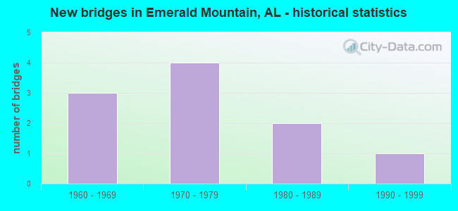
- New bridges - historical statistics
- 31960-1969
- 41970-1979
- 21980-1989
- 11990-1999


- Bridge Condition - Deck
- 10.0%Very good
- 40.0%Good
- 40.0%Satisfactory
- 10.0%Fair

- Bridge Condition - Superstructure
- 70.0%Good
- 20.0%Satisfactory
- 10.0%Fair

- Bridge Condition - Substructure
- 60.0%Good
- 30.0%Satisfactory
- 10.0%Poor

- Bridge Condition - Channel
- 10.0%Very good
- 80.0%Good
- 10.0%Satisfactory
Find on map >> Show street view
Structure Number: 3561, Location: SEC 23 T17N R19E (Lat: 32.444700, Lng: -86.127603), Route carried "on" structure: County highway , Year Built: 1968, Year Reconstructed: 1993, Status: Open, Structure Length: 1.74m (5.71ft), Average Daily Traffic: 20 (year 1998), Average Future Daily Traffic: 25 (year 2031), Design Load: H 15, Features Intersected: BRENSON BRANCH, Facility Carried by Structure: Brenson Creek Road
Minimum Vertical Clearance: 30+ m (98+ ft), Kilometerpoint: 0.010, Lanes on structure: 2, Owner: County Highway Agency, Approaching Roadway Width: 8.5m (27.9ft), Material/Design: Concrete, Design/Construction: Channel Beam, Number Of Spans In Main Unit: 3, Length of Maximum Span: 5.8m (19.0ft), Curb-To-Curb Width: 6.8m (22.3ft), Out-to-Out Width: 7.3m (24.0ft)
Condition: Deck: Satisfactory, Superstructure: Satisfactory, Substructure: Satisfactory, Channel: Good, Operating Rating: 47.4 metric tons, Method Used To Determine Operating Rating: Load Factor (LF), Inventory Rating: 28.4 metric tons, Method Used To Determine Inventory Rating: Load Factor (LF), Structural Evaluation: Equal to present minimum criteria, Deck Geometry: Somewhat better than minimum adequacy, Waterway Adequacy: Equal to present desirable criteria, Approach Roadway Alignment: Better than present minimum criteria, Length Of Structure Improvement: 2.44m (8.01ft), Designated Inspection Frequency: Every 24 months, Inspection Date: October 2020, Bridge Improvement Cost: $402,000, Roadway Improvement Cost: $40,000, Total Project Cost: $442,000 ( Estimate for 2022), Deck Structure Type: Concrete Precast Panels
Find on map >> Show street view
Structure Number: 6922, Location: SEC 11 T20N R17E (Lat: 32.466000, Lng: -86.023200), Route carried "on" structure: County highway 4, Year Built: 1960, Status: Posted for load, Structure Length: 2.31m (7.58ft), Average Daily Traffic: 1,103 (year 2004), Truck Traffic: 10%, Average Future Daily Traffic: 2,000 (year 2032), Design Load: H 15, Features Intersected: GOODWATER CREEK, Facility Carried by Structure: Rifle Range Road
Minimum Vertical Clearance: 30+ m (98+ ft), Kilometerpoint: 0.010, Lanes on structure: 2, Owner: County Highway Agency, Approaching Roadway Width: 8.5m (27.9ft), Material/Design: Concrete, Design/Construction: Channel Beam, Number Of Spans In Main Unit: 4, Length of Maximum Span: 5.8m (19.0ft), Curb-To-Curb Width: 7.3m (24.0ft), Out-to-Out Width: 7.9m (25.9ft)
Condition: Deck: Fair, Superstructure: Fair, Substructure: Poor, Channel: Satisfactory, Operating Rating: 22.7 metric tons, Method Used To Determine Operating Rating: Load Factor (LF), Inventory Rating: 13.6 metric tons, Method Used To Determine Inventory Rating: Load Factor (LF), Structural Evaluation: Meets minimum limits, Deck Geometry: Meets minimum limits, Waterway Adequacy: Better than present minimum criteria, Approach Roadway Alignment: Equal to present minimum criteria, Bridge Posting: Required (Relationship of Operating Rating to Maximum Legal Load: > 39.9% below), Length Of Structure Improvement: 3.14m (10.30ft), Designated Inspection Frequency: Every 24 months, Other Special Inspection Frequency: Every 12 months, Inspection Date: November 2020, Other Special Inspection Date: November 2021, Bridge Improvement Cost: $539,000, Roadway Improvement Cost: $54,000, Total Project Cost: $593,000 ( Estimate for 2022), Deck Structure Type: Concrete Precast Panels, Wearing Surface/Protective System: Wearing Surface: Bituminous
Find on map >> Show street view
Structure Number: 933, Location: 3.1 MI NW OF US 80 (Lat: 32.403097, Lng: -86.114606), Route carried "on" structure: County highway 12, Year Built: 1967, Status: Open, Structure Length: 6.95m (22.80ft), Average Daily Traffic: 1,200 (year 1988), Truck Traffic: 1%, Average Future Daily Traffic: 4,500 (year 2040), Design Load: HS 20, Features Intersected: JENKINS CREEK, Facility Carried by Structure: WARES FERRY ROAD
Minimum Vertical Clearance: 30+ m (98+ ft), Kilometerpoint: 0.010, Lanes on structure: 2, Owner: County Highway Agency, Approaching Roadway Width: 7.9m (25.9ft), Material/Design: Concrete, Design/Construction: Channel Beam, Number Of Spans In Main Unit: 11, Length of Maximum Span: 5.8m (19.0ft), Curb-To-Curb Width: 7.6m (24.9ft), Out-to-Out Width: 8.5m (27.9ft)
Condition: Deck: Satisfactory, Superstructure: Satisfactory, Substructure: Good, Channel: Good, Operating Rating: 46.5 metric tons, Method Used To Determine Operating Rating: Load Factor (LF), Inventory Rating: 27.9 metric tons, Method Used To Determine Inventory Rating: Load Factor (LF), Structural Evaluation: Equal to present minimum criteria, Deck Geometry: Meets minimum limits, Waterway Adequacy: Better than present minimum criteria, Approach Roadway Alignment: Equal to present desirable criteria, Length Of Structure Improvement: 7.98m (26.18ft), Designated Inspection Frequency: Every 24 months, Inspection Date: August 2020, Bridge Improvement Cost: $1,478,000, Roadway Improvement Cost: $148,000, Total Project Cost: $1,626,000 ( Estimate for 2022), Deck Structure Type: Concrete Precast Panels, Wearing Surface/Protective System: Membrane: Other, Deck Protection: Other
Find on map >> Show street view
Structure Number: 10273, Location: SEC 17 T17N R20E (Lat: 32.448492, Lng: -86.079417), Route carried "on" structure: County highway 4, Year Built: 1970, Status: Posted for load, Structure Length: 6.58m (21.59ft), Average Daily Traffic: 300 (year 1998), Truck Traffic: 10%, Average Future Daily Traffic: 350 (year 2031), Design Load: H 15, Features Intersected: CHUBBAHATCHEE CREEK, Facility Carried by Structure: Rifle Range Road
Minimum Vertical Clearance: 30+ m (98+ ft), Kilometerpoint: 0.010, Lanes on structure: 2, Owner: County Highway Agency, Approaching Roadway Width: 8.5m (27.9ft), Material/Design: Concrete, Design/Construction: Channel Beam, Number Of Spans In Main Unit: 9, Length of Maximum Span: 10.4m (34.1ft), Curb-To-Curb Width: 7.4m (24.3ft), Out-to-Out Width: 7.9m (25.9ft)
Condition: Deck: Satisfactory, Superstructure: Good, Substructure: Satisfactory, Channel: Good, Operating Rating: 40.1 metric tons, Method Used To Determine Operating Rating: Allowable Stress (AS), Inventory Rating: 24.1 metric tons, Method Used To Determine Inventory Rating: Allowable Stress (AS), Structural Evaluation: Equal to present minimum criteria, Deck Geometry: Somewhat better than minimum adequacy, Waterway Adequacy: Better than present minimum criteria, Approach Roadway Alignment: Equal to present minimum criteria, Bridge Posting: Required (Relationship of Operating Rating to Maximum Legal Load: 0.1 - 9.9% below), Length Of Structure Improvement: 7.62m (25.00ft), Designated Inspection Frequency: Every 24 months, Other Special Inspection Frequency: Every 12 months, Inspection Date: September 2020, Other Special Inspection Date: September 2021, Bridge Improvement Cost: $1,306,000, Roadway Improvement Cost: $131,000, Total Project Cost: $1,437,000 ( Estimate for 2022), Deck Structure Type: Concrete Precast Panels, Wearing Surface/Protective System: Wearing Surface: Bituminous
Find on map >> Show street view
Structure Number: 10274, Location: SEC 17 T17N R20E (Lat: 32.449308, Lng: -86.078617), Route carried "on" structure: County highway 4, Year Built: 1970, Status: Open, Structure Length: 3.47m (11.38ft), Average Daily Traffic: 350 (year 1998), Truck Traffic: 10%, Average Future Daily Traffic: 400 (year 2031), Design Load: H 15, Features Intersected: CHUBBAHATCHEE CREEK, Facility Carried by Structure: Rifle Range Road
Minimum Vertical Clearance: 30+ m (98+ ft), Kilometerpoint: 0.010, Lanes on structure: 2, Owner: County Highway Agency, Approaching Roadway Width: 8.5m (27.9ft), Material/Design: Concrete, Design/Construction: Channel Beam, Number Of Spans In Main Unit: 6, Length of Maximum Span: 5.8m (19.0ft), Curb-To-Curb Width: 7.4m (24.3ft), Out-to-Out Width: 7.9m (25.9ft)
Condition: Deck: Good, Superstructure: Good, Substructure: Good, Channel: Good, Operating Rating: 46.0 metric tons, Method Used To Determine Operating Rating: Load Factor (LF), Inventory Rating: 27.6 metric tons, Method Used To Determine Inventory Rating: Load Factor (LF), Structural Evaluation: Equal to present minimum criteria, Deck Geometry: Somewhat better than minimum adequacy, Waterway Adequacy: Better than present minimum criteria, Approach Roadway Alignment: Better than present minimum criteria, Length Of Structure Improvement: 4.37m (14.34ft), Designated Inspection Frequency: Every 24 months, Inspection Date: September 2020, Bridge Improvement Cost: $749,000, Roadway Improvement Cost: $75,000, Total Project Cost: $824,000 ( Estimate for 2022), Deck Structure Type: Concrete Precast Panels, Wearing Surface/Protective System: Wearing Surface: Bituminous
Find on map >> Show street view
Structure Number: 11186, Location: SEC 23 717N R19E (Lat: 32.438489, Lng: -86.122114), Route carried "on" structure: County highway 4, Year Built: 1974, Status: Open, Structure Length: 4.06m (13.32ft), Average Daily Traffic: 4,160 (year 2004), Truck Traffic: 10%, Average Future Daily Traffic: 6,500 (year 2031), Design Load: H 15, Features Intersected: BRENSEN BRANCH, Facility Carried by Structure: Rifle Range Road
Minimum Vertical Clearance: 30+ m (98+ ft), Kilometerpoint: 0.010, Lanes on structure: 2, Owner: County Highway Agency, Approaching Roadway Width: 8.5m (27.9ft), Material/Design: Concrete, Design/Construction: Channel Beam, Number Of Spans In Main Unit: 7, Length of Maximum Span: 5.8m (19.0ft), Curb-To-Curb Width: 7.9m (25.9ft), Out-to-Out Width: 8.5m (27.9ft)
Condition: Deck: Good, Superstructure: Good, Substructure: Good, Channel: Good, Operating Rating: 45.9 metric tons, Method Used To Determine Operating Rating: Load Factor (LF), Inventory Rating: 27.5 metric tons, Method Used To Determine Inventory Rating: Load Factor (LF), Structural Evaluation: Equal to present minimum criteria, Deck Geometry: High priority of corrective action, Waterway Adequacy: Equal to present desirable criteria, Approach Roadway Alignment: Better than present minimum criteria, Length Of Structure Improvement: 5.02m (16.47ft), Designated Inspection Frequency: Every 24 months, Inspection Date: September 2020, Bridge Improvement Cost: $929,000, Roadway Improvement Cost: $93,000, Total Project Cost: $1,022,000 ( Estimate for 2022), Deck Structure Type: Concrete Precast Panels, Wearing Surface/Protective System: Wearing Surface: Bituminous
Find on map >> Show street view
Structure Number: 11945, Location: SEC 24 T17N R19E (Lat: 32.439911, Lng: -86.119397), Route carried "on" structure: County highway , Year Built: 1978, Status: Open, Structure Length: 1.74m (5.71ft), Average Daily Traffic: 3,710 (year 2008), Truck Traffic: 12%, Average Future Daily Traffic: 5,000 (year 2032), Design Load: H 15, Features Intersected: BRENSON BRANCH, Facility Carried by Structure: Peace Church Road
Minimum Vertical Clearance: 30+ m (98+ ft), Kilometerpoint: 0.010, Lanes on structure: 2, Owner: County Highway Agency, Approaching Roadway Width: 8.5m (27.9ft), Material/Design: Concrete, Design/Construction: Channel Beam, Number Of Spans In Main Unit: 3, Length of Maximum Span: 5.8m (19.0ft), Curb-To-Curb Width: 7.9m (25.9ft), Out-to-Out Width: 8.5m (27.9ft)
Condition: Deck: Good, Superstructure: Good, Substructure: Good, Channel: Good, Operating Rating: 45.9 metric tons, Method Used To Determine Operating Rating: Load Factor (LF), Inventory Rating: 27.5 metric tons, Method Used To Determine Inventory Rating: Load Factor (LF), Structural Evaluation: Equal to present minimum criteria, Deck Geometry: High priority of corrective action, Waterway Adequacy: Equal to present desirable criteria, Approach Roadway Alignment: Better than present minimum criteria, Length Of Structure Improvement: 2.44m (8.01ft), Designated Inspection Frequency: Every 24 months, Inspection Date: November 2020, Bridge Improvement Cost: $468,000, Roadway Improvement Cost: $47,000, Total Project Cost: $515,000 ( Estimate for 2022), Deck Structure Type: Concrete Precast Panels, Wearing Surface/Protective System: Wearing Surface: Bituminous
Find on map >> Show street view
Structure Number: 12537, Location: SEC.24,T17N,R19E (Lat: 32.438000, Lng: -86.114544), Route carried "on" structure: County highway 4, Year Built: 1981, Status: Open, Structure Length: 1.74m (5.71ft), Average Daily Traffic: 4,160 (year 2004), Truck Traffic: 10%, Average Future Daily Traffic: 8,000 (year 2031), Design Load: H 15, Features Intersected: BRENSEN CREEK SPUR, Facility Carried by Structure: Rifle Range Road
Minimum Vertical Clearance: 30+ m (98+ ft), Kilometerpoint: 0.010, Lanes on structure: 2, Owner: County Highway Agency, Approaching Roadway Width: 8.5m (27.9ft), Material/Design: Concrete, Design/Construction: Channel Beam, Number Of Spans In Main Unit: 3, Length of Maximum Span: 5.8m (19.0ft), Curb-To-Curb Width: 7.9m (25.9ft), Out-to-Out Width: 8.5m (27.9ft)
Condition: Deck: Good, Superstructure: Good, Substructure: Satisfactory, Channel: Very good, Operating Rating: 45.9 metric tons, Method Used To Determine Operating Rating: Load Factor (LF), Inventory Rating: 27.5 metric tons, Method Used To Determine Inventory Rating: Load Factor (LF), Structural Evaluation: Equal to present minimum criteria, Deck Geometry: High priority of corrective action, Waterway Adequacy: Better than present minimum criteria, Approach Roadway Alignment: Better than present minimum criteria, Length Of Structure Improvement: 2.44m (8.01ft), Designated Inspection Frequency: Every 24 months, Underwater Inspection Frequency: Every 48 months, Inspection Date: September 2020, Underwater Inspection Date: August 2018, Bridge Improvement Cost: $452,000, Roadway Improvement Cost: $45,000, Total Project Cost: $497,000 ( Estimate for 2022), Deck Structure Type: Concrete Precast Panels, Wearing Surface/Protective System: Wearing Surface: Bituminous, Deck Protection: Other
Find on map >> Show street view
Structure Number: 1321, Location: 2.6 MILE NORTH U S 80 (Lat: 32.399644, Lng: -86.036292), Route carried "on" structure: County highway , Year Built: 1984, Status: Open, Structure Length: 2.19m (7.19ft), Average Daily Traffic: 280 (year 1988), Truck Traffic: 1%, Average Future Daily Traffic: 500 (year 2040), Design Load: H 10, Features Intersected: CREEK, Facility Carried by Structure: ALEXANDER ROAD
Minimum Vertical Clearance: 30+ m (98+ ft), Kilometerpoint: 0.010, Lanes on structure: 2, Owner: County Highway Agency, Approaching Roadway Width: 11.0m (36.1ft), Material/Design: Concrete, Design/Construction: Channel Beam, Number Of Spans In Main Unit: 3, Length of Maximum Span: 7.3m (24.0ft), Curb-To-Curb Width: 7.5m (24.6ft), Out-to-Out Width: 8.3m (27.2ft)
Condition: Deck: Very good, Superstructure: Good, Substructure: Good, Channel: Good, Operating Rating: 77.7 metric tons, Method Used To Determine Operating Rating: Allowable Stress (AS), Inventory Rating: 51.7 metric tons, Method Used To Determine Inventory Rating: Allowable Stress (AS), Structural Evaluation: Better than present minimum criteria, Deck Geometry: Somewhat better than minimum adequacy, Waterway Adequacy: Better than present minimum criteria, Approach Roadway Alignment: Equal to present minimum criteria, Length Of Structure Improvement: 2.99m (9.81ft), Designated Inspection Frequency: Every 24 months, Inspection Date: May 2020, Bridge Improvement Cost: $554,000, Roadway Improvement Cost: $55,000, Total Project Cost: $609,000 ( Estimate for 2022), Deck Structure Type: Concrete Precast Panels
Find on map >> Show street view
Structure Number: 16767, Location: EMERALD MT TOLL ROAD (Lat: 32.433000, Lng: -86.124900), Route carried "on" structure: Alternate Other road 74, Year Built: 1994, Status: Open, Structure Length: 11.46m (37.60ft), Average Daily Traffic: 2,354 (year 2020), Truck Traffic: 12%, Average Future Daily Traffic: 2,994 (year 2040), Design Load: HS 20, Features Intersected: TALLAPOOSA RIVER, Facility Carried by Structure: EMERALD MT RD
Minimum Vertical Clearance: 30+ m (98+ ft), Kilometerpoint: 0.000, Lanes on structure: 2, Toll: Toll bridge, Owner: Private, Approaching Roadway Width: 7.3m (24.0ft), Material/Design: Prestressed concrete, Design/Construction: Stringer/Multi-beam, Number Of Spans In Main Unit: 3, Length of Maximum Span: 38.1m (125.0ft), Curb-To-Curb Width: 8.5m (27.9ft), Out-to-Out Width: 9.4m (30.8ft)
Condition: Deck: Satisfactory, Superstructure: Good, Substructure: Good, Channel: Good, Operating Rating: 76.4 metric tons, Method Used To Determine Operating Rating: Load Factor (LF), Inventory Rating: 24.2 metric tons, Method Used To Determine Inventory Rating: Load Factor (LF), Structural Evaluation: Equal to present minimum criteria, Deck Geometry: Meets minimum limits, Waterway Adequacy: Equal to present desirable criteria, Approach Roadway Alignment: Equal to present desirable criteria, Length Of Structure Improvement: 12.33m (40.45ft), Designated Inspection Frequency: Every 24 months, Underwater Inspection Frequency: Every 24 months, Inspection Date: October 2020, Underwater Inspection Date: October 2020, Bridge Improvement Cost: $2,537,000, Roadway Improvement Cost: $254,000, Total Project Cost: $2,791,000 ( Estimate for 2022), Deck Structure Type: Concrete Cast-file-Place