Bridge Statistics for Emlenton, Pennsylvania (PA)
Condition, Traffic, Stress, Structural Evaluation, Project Costs
- National Bridge Inventory (NBI) Statistics
- 25Number of bridges
- 341ft / 104mTotal length
- $14,102,000Total costs
- 124,364Total average daily traffic
- 46,952Total average daily truck traffic
- National Bridge Inventory (NBI) Registered Bridges for Emlenton
- No street view available for this location
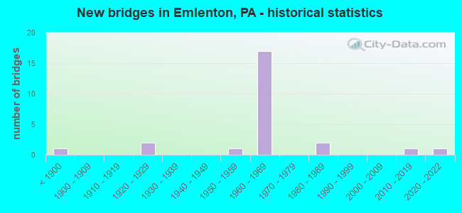
- New bridges - historical statistics
- 1Before 1900
- 21920-1929
- 11950-1959
- 171960-1969
- 21980-1989
- 12010-2019
- 12020-2022
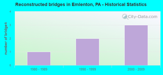
- Reconstructed bridges - Historical Statistics
- 11980-1989
- 21990-1999
- 32000-2009
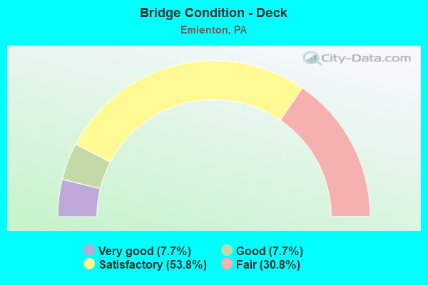
- Bridge Condition - Deck
- 7.7%Very good
- 7.7%Good
- 53.8%Satisfactory
- 30.8%Fair
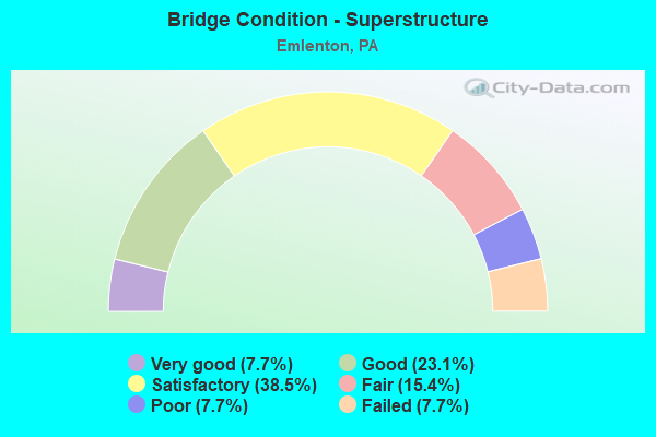
- Bridge Condition - Superstructure
- 7.7%Very good
- 23.1%Good
- 38.5%Satisfactory
- 15.4%Fair
- 7.7%Poor
- 7.7%Failed
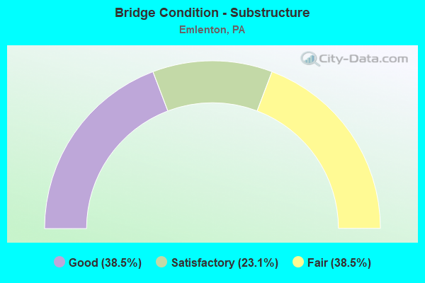
- Bridge Condition - Substructure
- 38.5%Good
- 23.1%Satisfactory
- 38.5%Fair
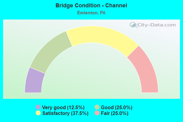
- Bridge Condition - Channel
- 12.5%Very good
- 25.0%Good
- 37.5%Satisfactory
- 25.0%Fair
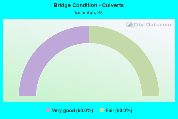
- Bridge Condition - Culverts
- 50.0%Very good
- 50.0%Fair
Find on map >> Show street view
Structure Number: 7888, Location: SQUAW VALLEY RD EB (Lat: 41.169839, Lng: -79.708256), Route carried "on" structure: Interstate 80, Year Built: 1965, Status: Open, Structure Length: 1.19m (3.90ft), Average Daily Traffic: 11,053 (year 2022), Truck Traffic: 39%, Average Future Daily Traffic: 16,943 (year 2032), Design Load: HS 20+Mod, Features Intersected: T-538, SQUAW VALLEY RD
Minimum Vertical Clearance: 30+ m (98+ ft), Kilometerpoint: 1.809, Lanes on structure: 2, Lanes under structure: 2, Base Highway Network: Yes, Owner: State Highway Agency, Approaching Roadway Width: 11.6m (38.1ft), Skew: 13 degrees, Material/Design: Prestressed concrete, Design/Construction: Box Beam or Girders - Single/Spread, Number Of Spans In Main Unit: 1, Length of Maximum Span: 11.6m (38.1ft), Curb or Sidewalk Widths: Left: 0.2m (0.7ft), Right: 0.2m (0.7ft), Curb-To-Curb Width: 12.2m (40.0ft), Out-to-Out Width: 13.3m (43.6ft)
Condition: Deck: Satisfactory, Superstructure: Good, Substructure: Good, Operating Rating: 56.2 metric tons, Method Used To Determine Operating Rating: Load Factor (LF), Inventory Rating: 33.6 metric tons, Method Used To Determine Inventory Rating: Load Factor (LF), Structural Evaluation: Better than present minimum criteria, Deck Geometry: Better than present minimum criteria, Underclear: Meets minimum limits, Approach Roadway Alignment: Equal to present desirable criteria, Length Of Structure Improvement: 1.80m (5.91ft), Designated Inspection Frequency: Every 24 months, Inspection Date: September 2020, Deck Structure Type: Concrete Cast-file-Place, Wearing Surface/Protective System: Wearing Surface: Epoxy Overlay, Membrane: Epoxy
Find on map >> Show street view
Structure Number: 7889, Location: SQUAW VALLEY ROAD WB (Lat: 41.170200, Lng: -79.708333), Route carried "on" structure: Interstate 80, Year Built: 1965, Status: Open, Structure Length: 1.19m (3.90ft), Average Daily Traffic: 12,530 (year 2022), Truck Traffic: 44%, Average Future Daily Traffic: 19,010 (year 2032), Design Load: HS 20+Mod, Features Intersected: T-538, SQUAW VALLEY RD
Minimum Vertical Clearance: 30+ m (98+ ft), Kilometerpoint: 1.764, Lanes on structure: 2, Lanes under structure: 2, Base Highway Network: Yes, Owner: State Highway Agency, Approaching Roadway Width: 11.6m (38.1ft), Skew: 13 degrees, Material/Design: Prestressed concrete, Design/Construction: Box Beam or Girders - Single/Spread, Number Of Spans In Main Unit: 1, Length of Maximum Span: 11.6m (38.1ft), Curb or Sidewalk Widths: Left: 0.2m (0.7ft), Right: 0.2m (0.7ft), Curb-To-Curb Width: 12.2m (40.0ft), Out-to-Out Width: 13.3m (43.6ft)
Condition: Deck: Satisfactory, Superstructure: Good, Substructure: Good, Operating Rating: 56.2 metric tons, Method Used To Determine Operating Rating: Load Factor (LF), Inventory Rating: 33.6 metric tons, Method Used To Determine Inventory Rating: Load Factor (LF), Structural Evaluation: Better than present minimum criteria, Deck Geometry: Better than present minimum criteria, Underclear: Meets minimum limits, Approach Roadway Alignment: Equal to present desirable criteria, Length Of Structure Improvement: 1.80m (5.91ft), Designated Inspection Frequency: Every 24 months, Inspection Date: September 2020, Deck Structure Type: Concrete Cast-file-Place, Wearing Surface/Protective System: Wearing Surface: Epoxy Overlay, Membrane: Epoxy
Find on map >> Show street view
Structure Number: 8162, Location: .25 mi SW of Grewick Rd (Lat: 41.165339, Lng: -79.710819), Route carried "on" structure: City street , Year Built: 1921, Year Reconstructed: 1990, Status: Open, Structure Length: 0.98m (3.22ft), Average Daily Traffic: 100 (year 2017), Truck Traffic: 9%, Average Future Daily Traffic: 120 (year 2037), Features Intersected: LOWREY RUN, Facility Carried by Structure: T-538 SQUAW VALLEY
Minimum Vertical Clearance: 30+ m (98+ ft), Kilometerpoint: 0.000, Lanes on structure: 1, Owner: County Highway Agency, Approaching Roadway Width: 4.6m (15.1ft), Material/Design: Steel, Design/Construction: Stringer/Multi-beam, Number Of Spans In Main Unit: 1, Length of Maximum Span: 8.8m (28.9ft), Curb or Sidewalk Widths: Left: 0.2m (0.7ft), Right: 0.2m (0.7ft), Curb-To-Curb Width: 3.9m (12.8ft), Out-to-Out Width: 4.4m (14.4ft)
Condition: Deck: Satisfactory, Superstructure: Satisfactory, Substructure: Fair, Channel: Fair, Operating Rating: 76.2 metric tons, Method Used To Determine Operating Rating: Load Factor (LF), Inventory Rating: 45.4 metric tons, Method Used To Determine Inventory Rating: Load Factor (LF), Structural Evaluation: Somewhat better than minimum adequacy, Deck Geometry: Meets minimum limits, Waterway Adequacy: Better than present minimum criteria, Approach Roadway Alignment: Equal to present desirable criteria, Length Of Structure Improvement: 1.60m (5.25ft), Designated Inspection Frequency: Every 24 months, Inspection Date: August 2021, Deck Structure Type: Concrete Cast-file-Place, Wearing Surface/Protective System: Wearing Surface: Monolithic Concrete, Deck Protection: Epoxy Coated Reinforcing
Find on map >> Show street view
Structure Number: 1093, Location: EMLENTON (Lat: 41.174858, Lng: -79.697000), Route carried "on" structure: Interstate 80, Year Built: 1966, Year Reconstructed: 2013, Status: Open, Structure Length: 51.05m (167.49ft), Average Daily Traffic: 23,583 (year 2022), Truck Traffic: 41%, Average Future Daily Traffic: 35,202 (year 2032), Design Load: HS 20+Mod, Features Intersected: ALLEGHENY RIV;SR0268;RR
Minimum Vertical Clearance: 30+ m (98+ ft), Kilometerpoint: 0.000, Lanes on structure: 4, Lanes under structure: 2, Base Highway Network: Yes, Owner: State Highway Agency, Approaching Roadway Width: 18.9m (62.0ft), Skew: 30 degrees, Material/Design: Steel continuous, Design/Construction: Truss - Deck, Number Of Spans In Main Unit: 3, Number Of Approach Spans: 2, Length of Maximum Span: 164.6m (540.0ft), Curb or Sidewalk Widths: Left: 0.2m (0.7ft), Right: 0.2m (0.7ft), Curb-To-Curb Width: 18.7m (61.4ft), Out-to-Out Width: 20.8m (68.2ft)
Condition: Deck: Satisfactory, Superstructure: Fair, Substructure: Good, Channel: Satisfactory, Operating Rating: 59.9 metric tons, Method Used To Determine Operating Rating: Load Factor (LF), Inventory Rating: 36.3 metric tons, Method Used To Determine Inventory Rating: Load Factor (LF), Structural Evaluation: Somewhat better than minimum adequacy, Deck Geometry: Meets minimum limits, Underclear: Superior to present desirable criteria, Waterway Adequacy: Superior to present desirable criteria, Approach Roadway Alignment: Better than present minimum criteria, Length Of Structure Improvement: 51.80m (169.95ft), Designated Inspection Frequency: Every 24 months, Critical Feature Inspection Frequency: Every 24 months, Underwater Inspection Frequency: Every 60 months, Inspection Date: March 2021, Critical Feature Inspection Date: March 2021, Underwater Inspection Date: October 2020, Bridge Improvement Cost: $782,000, Roadway Improvement Cost: $2,304,000, Total Project Cost: $10,560,000, Deck Structure Type: Concrete Cast-file-Place, Wearing Surface/Protective System: Wearing Surface: Latex Concrete, Deck Protection: Epoxy Coated Reinforcing
Find on map >> Show street view
Structure Number: 10931, Location: METZ ROAD EB (Lat: 41.179917, Lng: -79.689014), Route carried "on" structure: Interstate 80, Year Built: 1966, Status: Open, Structure Length: 4.57m (14.99ft), Average Daily Traffic: 11,053 (year 2022), Truck Traffic: 39%, Average Future Daily Traffic: 16,589 (year 2032), Design Load: HS 20+Mod, Features Intersected: T-310 METZ RD
Minimum Vertical Clearance: 30+ m (98+ ft), Kilometerpoint: 0.510, Lanes on structure: 2, Lanes under structure: 2, Base Highway Network: Yes, Owner: State Highway Agency, Approaching Roadway Width: 11.6m (38.1ft), Skew: 10 degrees, Material/Design: Prestressed concrete continuous, Design/Construction: Box Beam or Girders - Single/Spread, Number Of Spans In Main Unit: 3, Length of Maximum Span: 15.2m (49.9ft), Curb or Sidewalk Widths: Left: 0.2m (0.7ft), Right: 0.2m (0.7ft), Curb-To-Curb Width: 12.6m (41.3ft), Out-to-Out Width: 13.9m (45.6ft)
Condition: Deck: Satisfactory, Superstructure: Satisfactory, Substructure: Satisfactory, Operating Rating: 84.4 metric tons, Method Used To Determine Operating Rating: Load Factor (LF), Inventory Rating: 47.2 metric tons, Method Used To Determine Inventory Rating: Load Factor (LF), Structural Evaluation: Equal to present minimum criteria, Deck Geometry: Better than present minimum criteria, Underclear: Meets minimum limits, Approach Roadway Alignment: Equal to present desirable criteria, Length Of Structure Improvement: 5.50m (18.04ft), Designated Inspection Frequency: Every 48 months, Inspection Date: April 2021, Bridge Improvement Cost: $36,000, Roadway Improvement Cost: $107,000, Total Project Cost: $488,000, Deck Structure Type: Concrete Cast-file-Place, Wearing Surface/Protective System: Wearing Surface: Epoxy Overlay, Membrane: Epoxy, Deck Protection: Epoxy Coated Reinforcing
Find on map >> Show street view
Structure Number: 10932, Location: METZ ROAD WB (Lat: 41.180194, Lng: -79.689197), Route carried "on" structure: Interstate 80, Year Built: 1966, Status: Open, Structure Length: 5.58m (18.31ft), Average Daily Traffic: 12,530 (year 2022), Truck Traffic: 44%, Average Future Daily Traffic: 18,613 (year 2032), Design Load: HS 20+Mod, Features Intersected: T-310 METZ ROAD
Minimum Vertical Clearance: 30+ m (98+ ft), Kilometerpoint: 0.510, Lanes on structure: 2, Lanes under structure: 2, Base Highway Network: Yes, Owner: State Highway Agency, Approaching Roadway Width: 11.6m (38.1ft), Skew: 10 degrees, Material/Design: Prestressed concrete continuous, Design/Construction: Box Beam or Girders - Single/Spread, Number Of Spans In Main Unit: 3, Length of Maximum Span: 18.6m (61.0ft), Curb or Sidewalk Widths: Left: 0.2m (0.7ft), Right: 0.2m (0.7ft), Curb-To-Curb Width: 12.6m (41.3ft), Out-to-Out Width: 13.9m (45.6ft)
Condition: Deck: Satisfactory, Superstructure: Satisfactory, Substructure: Satisfactory, Operating Rating: 88.9 metric tons, Method Used To Determine Operating Rating: Load Factor (LF), Inventory Rating: 39.9 metric tons, Method Used To Determine Inventory Rating: Load Factor (LF), Structural Evaluation: Equal to present minimum criteria, Deck Geometry: Better than present minimum criteria, Underclear: Meets minimum limits, Approach Roadway Alignment: Equal to present desirable criteria, Length Of Structure Improvement: 6.50m (21.33ft), Designated Inspection Frequency: Every 48 months, Inspection Date: April 2021, Bridge Improvement Cost: $43,000, Roadway Improvement Cost: $126,000, Total Project Cost: $577,000, Deck Structure Type: Concrete Cast-file-Place, Wearing Surface/Protective System: Wearing Surface: Epoxy Overlay, Membrane: Epoxy, Deck Protection: Epoxy Coated Reinforcing
Find on map >> Show street view
Structure Number: 10934, Location: ST.PETERSBURG RD WB (Lat: 41.183706, Lng: -79.675261), Route carried "on" structure: Interstate 80, Year Built: 1966, Year Reconstructed: 1996, Status: Open, Structure Length: 3.44m (11.29ft), Average Daily Traffic: 12,530 (year 2022), Truck Traffic: 44%, Average Future Daily Traffic: 18,613 (year 2032), Design Load: HS 20+Mod, Features Intersected: SR0478, ST PETERSBURG RD
Minimum Vertical Clearance: 30+ m (98+ ft), Kilometerpoint: 2.081, Lanes on structure: 3, Lanes under structure: 2, Base Highway Network: Yes, Owner: State Highway Agency, Approaching Roadway Width: 15.2m (49.9ft), Skew: 11 degrees, Material/Design: Prestressed concrete continuous, Design/Construction: Box Beam or Girders - Single/Spread, Number Of Spans In Main Unit: 3, Length of Maximum Span: 14.0m (45.9ft), Curb or Sidewalk Widths: Left: 0.2m (0.7ft), Right: 0.2m (0.7ft), Curb-To-Curb Width: 15.4m (50.5ft), Out-to-Out Width: 16.3m (53.5ft)
Condition: Deck: Satisfactory, Superstructure: Satisfactory, Substructure: Satisfactory, Operating Rating: 84.4 metric tons, Method Used To Determine Operating Rating: Load Factor (LF), Inventory Rating: 46.3 metric tons, Method Used To Determine Inventory Rating: Load Factor (LF), Structural Evaluation: Equal to present minimum criteria, Deck Geometry: Somewhat better than minimum adequacy, Underclear: Somewhat better than minimum adequacy, Approach Roadway Alignment: Equal to present desirable criteria, Length Of Structure Improvement: 4.30m (14.11ft), Designated Inspection Frequency: Every 24 months, Inspection Date: May 2021, Deck Structure Type: Concrete Cast-file-Place, Wearing Surface/Protective System: Wearing Surface: Epoxy Overlay, Membrane: Epoxy, Deck Protection: Epoxy Coated Reinforcing
Find on map >> Show street view
Structure Number: 33674, Location: EMLENTON BOROUGH (Lat: 41.175592, Lng: -79.708108), Route carried "on" structure: State highway 38, Year Built: 1987, Status: Open, Structure Length: 20.48m (67.19ft), Average Daily Traffic: 1,319 (year 2022), Truck Traffic: 7%, Average Future Daily Traffic: 3,773 (year 2032), Design Load: HS 25 or greater, Features Intersected: OVER ALLGHNY R.& RIVER A
Minimum Vertical Clearance: 30+ m (98+ ft), Kilometerpoint: 3.050, Lanes on structure: 2, Lanes under structure: 2, Base Highway Network: Yes, Owner: State Highway Agency, Approaching Roadway Width: 11.0m (36.1ft), Material/Design: Steel continuous, Design/Construction: Stringer/Multi-beam, Number Of Spans In Main Unit: 3, Length of Maximum Span: 73.2m (240.2ft), Curb or Sidewalk Widths: Left: 0.2m (0.7ft), Right: 0.2m (0.7ft), Curb-To-Curb Width: 11.0m (36.1ft), Out-to-Out Width: 11.7m (38.4ft)
Condition: Deck: Good, Superstructure: Good, Substructure: Good, Channel: Good, Operating Rating: 69.9 metric tons, Method Used To Determine Operating Rating: Load Factor (LF), Inventory Rating: 32.7 metric tons, Method Used To Determine Inventory Rating: Load Factor (LF), Structural Evaluation: Better than present minimum criteria, Deck Geometry: Equal to present minimum criteria, Underclear: Superior to present desirable criteria, Waterway Adequacy: Superior to present desirable criteria, Approach Roadway Alignment: Equal to present desirable criteria, Length Of Structure Improvement: 20.50m (67.26ft), Designated Inspection Frequency: Every 24 months, Underwater Inspection Frequency: Every 60 months, Inspection Date: July 2020, Underwater Inspection Date: September 2021, Bridge Improvement Cost: $26,000, Roadway Improvement Cost: $78,000, Total Project Cost: $356,000, Deck Structure Type: Concrete Cast-file-Place, Wearing Surface/Protective System: Wearing Surface: Monolithic Concrete, Deck Protection: Epoxy Coated Reinforcing
Find on map >> Show street view
Structure Number: 33675, Location: EMLENTON BOROUGH (Lat: 41.183639, Lng: -79.682722), Route carried "on" structure: State highway 38, Year Built: 1928, Year Reconstructed: 1985, Status: Open, Structure Length: 1.22m (4.00ft), Average Daily Traffic: 1,319 (year 2022), Truck Traffic: 7%, Average Future Daily Traffic: 2,029 (year 2032), Design Load: HS 15, Features Intersected: OVER RICHEY RUN
Minimum Vertical Clearance: 30+ m (98+ ft), Kilometerpoint: 3.705, Lanes on structure: 2, Base Highway Network: Yes, Owner: State Highway Agency, Approaching Roadway Width: 9.4m (30.8ft), Skew: 5 degrees, Material/Design: Concrete, Design/Construction: Culvert, Number Of Spans In Main Unit: 1, Length of Maximum Span: 12.2m (40.0ft)
Condition: Channel: Fair, Culverts: Fair, Operating Rating: 68.9 metric tons, Method Used To Determine Operating Rating: Allowable Stress (AS), Inventory Rating: 40.8 metric tons, Method Used To Determine Inventory Rating: Allowable Stress (AS), Structural Evaluation: Somewhat better than minimum adequacy, Waterway Adequacy: Superior to present desirable criteria, Approach Roadway Alignment: Equal to present desirable criteria, Length Of Structure Improvement: 1.90m (6.23ft), Designated Inspection Frequency: Every 24 months, Inspection Date: July 2021
Find on map >> Show street view
Structure Number: 33717, Location: SCRUBGRASS TOWNSHIP (Lat: 41.173875, Lng: -79.739486), Route carried "on" structure: Interstate 80, Year Built: 1965, Year Reconstructed: 2012, Status: Open, Structure Length: 4.51m (14.80ft), Average Daily Traffic: 11,053 (year 2022), Truck Traffic: 39%, Average Future Daily Traffic: 17,119 (year 2032), Design Load: HS 20+Mod, Features Intersected: OVER SR 38
Minimum Vertical Clearance: 30+ m (98+ ft), Kilometerpoint: 22.932, Lanes on structure: 2, Lanes under structure: 2, Base Highway Network: Yes, Owner: State Highway Agency, Approaching Roadway Width: 11.6m (38.1ft), Skew: 14 degrees, Material/Design: Prestressed concrete, Design/Construction: Box Beam or Girders - Single/Spread, Number Of Spans In Main Unit: 3, Length of Maximum Span: 18.9m (62.0ft), Curb or Sidewalk Widths: Left: 0.2m (0.7ft), Right: 0.2m (0.7ft), Curb-To-Curb Width: 12.2m (40.0ft), Out-to-Out Width: 14.0m (45.9ft)
Condition: Deck: Fair, Superstructure: Satisfactory, Substructure: Fair, Operating Rating: 63.5 metric tons, Method Used To Determine Operating Rating: Load Factor (LF), Inventory Rating: 24.5 metric tons, Method Used To Determine Inventory Rating: Load Factor (LF), Structural Evaluation: Somewhat better than minimum adequacy, Deck Geometry: Better than present minimum criteria, Underclear: Somewhat better than minimum adequacy, Approach Roadway Alignment: Equal to present desirable criteria, Length Of Structure Improvement: 4.50m (14.76ft), Designated Inspection Frequency: Every 24 months, Inspection Date: November 2021, Bridge Improvement Cost: $27,000, Roadway Improvement Cost: $80,000, Total Project Cost: $367,000, Deck Structure Type: Concrete Cast-file-Place, Wearing Surface/Protective System: Wearing Surface: Bituminous, Membrane: Preformed Fabric
Find on map >> Show street view
Structure Number: 33718, Location: SCRUBGRASS TOWNSHIP (Lat: 41.174189, Lng: -79.739167), Route carried "on" structure: Interstate 80, Year Built: 1965, Year Reconstructed: 2012, Status: Open, Structure Length: 4.51m (14.80ft), Average Daily Traffic: 12,530 (year 2022), Truck Traffic: 44%, Average Future Daily Traffic: 19,207 (year 2032), Design Load: HS 20+Mod, Features Intersected: OVER SR 38
Minimum Vertical Clearance: 30+ m (98+ ft), Kilometerpoint: 22.952, Lanes on structure: 2, Lanes under structure: 2, Base Highway Network: Yes, Owner: State Highway Agency, Approaching Roadway Width: 11.6m (38.1ft), Skew: 14 degrees, Material/Design: Prestressed concrete, Design/Construction: Box Beam or Girders - Single/Spread, Number Of Spans In Main Unit: 3, Length of Maximum Span: 18.9m (62.0ft), Curb or Sidewalk Widths: Left: 0.2m (0.7ft), Right: 0.2m (0.7ft), Curb-To-Curb Width: 12.2m (40.0ft), Out-to-Out Width: 14.0m (45.9ft)
Condition: Deck: Fair, Superstructure: Fair, Substructure: Fair, Operating Rating: 89.8 metric tons, Method Used To Determine Operating Rating: Load Factor (LF), Inventory Rating: 44.5 metric tons, Method Used To Determine Inventory Rating: Load Factor (LF), Structural Evaluation: Somewhat better than minimum adequacy, Deck Geometry: Better than present minimum criteria, Underclear: High priority of corrective action, Approach Roadway Alignment: Equal to present desirable criteria, Length Of Structure Improvement: 5.50m (18.04ft), Designated Inspection Frequency: Every 24 months, Inspection Date: November 2021, Bridge Improvement Cost: $60,000, Roadway Improvement Cost: $176,000, Total Project Cost: $808,000, Deck Structure Type: Concrete Cast-file-Place, Wearing Surface/Protective System: Wearing Surface: Bituminous, Membrane: Preformed Fabric
Find on map >> Show street view
Structure Number: 33928, Location: ROCKLAND TOWNSHIP (Lat: 41.224872, Lng: -79.721972), Route carried "on" structure: City street , Year Built: 1885, Status: Closed, Structure Length: 1.89m (6.20ft), Average Daily Traffic: 75 (year 2015), Average Future Daily Traffic: 110 (year 2035), Design Load: H 10, Features Intersected: OVER MILL CREEK, Facility Carried by Structure: T-522, DOTTERER RD
Minimum Vertical Clearance: 30+ m (98+ ft), Kilometerpoint: 0.000, Lanes on structure: 1, Owner: County Highway Agency, Approaching Roadway Width: 3.0m (9.8ft), Skew: 2 degrees, Material/Design: Steel, Design/Construction: Truss - Thru, Number Of Spans In Main Unit: 1, Length of Maximum Span: 18.3m (60.0ft), Curb-To-Curb Width: 4.8m (15.7ft), Out-to-Out Width: 4.9m (16.1ft)
Condition: Deck: Fair, Superstructure: Failed, Substructure: Fair, Channel: Satisfactory, Operating Rating: 4.5 metric tons, Method Used To Determine Operating Rating: Allowable Stress (AS), Inventory Rating: 2.7 metric tons, Method Used To Determine Inventory Rating: Allowable Stress (AS), Deck Geometry: Equal to present desirable criteria, Waterway Adequacy: Equal to present desirable criteria, Approach Roadway Alignment: Meets minimum limits, Bridge Posting: Required (Relationship of Operating Rating to Maximum Legal Load: > 39.9% below), Length Of Structure Improvement: 2.30m (7.55ft), Designated Inspection Frequency: Every 24 months, Inspection Date: June 2020, Bridge Improvement Cost: $68,000, Roadway Improvement Cost: $196,000, Total Project Cost: $946,000, Deck Structure Type: Wood or Timber, Wearing Surface/Protective System: Wearing Surface: Wood or Timber
Find on map >> Show street view
Structure Number: 47236, Location: ROCKLAND TWP (Lat: 41.211733, Lng: -79.722781), Route carried "on" structure: City street , Year Built: 1959, Status: Posted for load, Structure Length: 0.82m (2.69ft), Average Daily Traffic: 100 (year 2015), Truck Traffic: 4%, Average Future Daily Traffic: 120 (year 2035), Design Load: H 20, Features Intersected: TRIB. TO ALLEGHENY RIVER, Facility Carried by Structure: DOTTERER ROAD
Minimum Vertical Clearance: 30+ m (98+ ft), Kilometerpoint: 0.000, Lanes on structure: 1, Owner: Town or Township Highway Agency, Maintenance Responsibility: County Highway Agency, Approaching Roadway Width: 4.3m (14.1ft), Material/Design: Steel, Design/Construction: Stringer/Multi-beam, Number Of Spans In Main Unit: 1, Length of Maximum Span: 7.9m (25.9ft), Curb or Sidewalk Widths: Left: 0.2m (0.7ft), Right: 0.2m (0.7ft), Curb-To-Curb Width: 4.5m (14.8ft), Out-to-Out Width: 4.9m (16.1ft)
Condition: Deck: Fair, Superstructure: Poor, Substructure: Fair, Channel: Satisfactory, Operating Rating: 16.3 metric tons, Method Used To Determine Operating Rating: Load Factor (LF), Inventory Rating: 10.0 metric tons, Method Used To Determine Inventory Rating: Load Factor (LF), Structural Evaluation: High priority of corrective action, Deck Geometry: Equal to present minimum criteria, Waterway Adequacy: Better than present minimum criteria, Approach Roadway Alignment: Equal to present desirable criteria, Bridge Posting: Required (Relationship of Operating Rating to Maximum Legal Load: > 39.9% below), Designated Inspection Frequency: Every 24 months, Other Special Inspection Frequency: Every 12 months, Inspection Date: May 2020, Other Special Inspection Date: May 2021, Deck Structure Type: Concrete Cast-file-Place, Wearing Surface/Protective System: Wearing Surface: Monolithic Concrete
Find on map >> Show street view
Structure Number: 48073, Location: SCRUBGRASS TWP (Lat: 41.173739, Lng: -79.719819), Route carried "on" structure: State highway 38, Year Built: 2013, Status: Open, Structure Length: 0.64m (2.10ft), Average Daily Traffic: 2,485 (year 2022), Truck Traffic: 13%, Average Future Daily Traffic: 3,599 (year 2033), Design Load: HL 93, Features Intersected: SUGAR VALLEY RUN
Minimum Vertical Clearance: 30+ m (98+ ft), Kilometerpoint: 1.859, Lanes on structure: 2, Base Highway Network: Yes, Owner: State Highway Agency, Approaching Roadway Width: 10.4m (34.1ft), Skew: 5 degrees, Material/Design: Concrete, Design/Construction: Culvert, Number Of Spans In Main Unit: 1, Length of Maximum Span: 6.4m (21.0ft)
Condition: Channel: Very good, Culverts: Very good, Operating Rating: 53.5 metric tons, Method Used To Determine Operating Rating: Assigned ratings based on Load and Resistance Factor Design (LRFD) reported by rating factor (RF) using HL93 loadings, Inventory Rating: 33.7 metric tons, Method Used To Determine Inventory Rating: Assigned ratings based on Load and Resistance Factor Design (LRFD) reported by rating factor (RF) using HL93 loadings, Structural Evaluation: Equal to present desirable criteria, Waterway Adequacy: Equal to present desirable criteria, Approach Roadway Alignment: Equal to present desirable criteria, Designated Inspection Frequency: Every 48 months, Inspection Date: September 2019
Find on map >> Show street view
Structure Number: 68432, Location: ROCKLAND TOWNSHIP (Lat: 41.224869, Lng: -79.721972), Route carried "on" structure: City street , Year Built: 2021, Status: Open, Structure Length: 1.89m (6.20ft), Average Daily Traffic: 100 (year 2021), Average Future Daily Traffic: 150 (year 2040), Design Load: HL 93, Features Intersected: OVER MILL CREEK, Facility Carried by Structure: T-522, DOTTERER RD
Minimum Vertical Clearance: 30+ m (98+ ft), Kilometerpoint: 0.000, Lanes on structure: 1, Owner: County Highway Agency, Approaching Roadway Width: 4.6m (15.1ft), Skew: 2 degrees, Material/Design: Concrete, Design/Construction: Box Beam or Girders - Single/Spread, Number Of Spans In Main Unit: 1, Length of Maximum Span: 18.3m (60.0ft), Curb-To-Curb Width: 4.8m (15.7ft), Out-to-Out Width: 5.6m (18.4ft)
Condition: Deck: Very good, Superstructure: Very good, Substructure: Good, Channel: Good, Operating Rating: 51.2 metric tons, Method Used To Determine Operating Rating: Assigned ratings based on Load and Resistance Factor Design (LRFD) reported by rating factor (RF) using HL93 loadings, Inventory Rating: 39.5 metric tons, Method Used To Determine Inventory Rating: Assigned ratings based on Load and Resistance Factor Design (LRFD) reported by rating factor (RF) using HL93 loadings, Structural Evaluation: Better than present minimum criteria, Deck Geometry: Equal to present desirable criteria, Waterway Adequacy: Equal to present desirable criteria, Approach Roadway Alignment: Equal to present minimum criteria, Designated Inspection Frequency: Every 24 months, Inspection Date: September 2021, Deck Structure Type: Concrete Cast-file-Place, Wearing Surface/Protective System: Wearing Surface: Monolithic Concrete, Deck Protection: Epoxy Coated Reinforcing
Find on map >> Show street view
Structure Number: 7888, Location: SQUAW VALLEY RD EB (Lat: 41.169839, Lng: -79.708256), Route carried "under" structure: City street , Year Built: 1965, Structure Length: 0. m, Average Daily Traffic: 100 (year 2005), Truck Traffic: 5%, Features Intersected: T-538, SQUAW VALLEY RD, Facility Carried by Structure: SR0080 EB
Minimum Vertical Clearance: 4.85m (15.91ft), Kilometerpoint: 0.000, Lanes on structure: 2, Lanes under structure: 2, Material/Design: Prestressed concrete, Design/Construction: Box Beam or Girders - Single/Spread, Length of Maximum Span: 11.6m (38.1ft)
Find on map >> Show street view
Structure Number: 7889, Location: SQUAW VALLEY ROAD WB (Lat: 41.170200, Lng: -79.708333), Route carried "under" structure: City street , Year Built: 1965, Structure Length: 0. m, Average Daily Traffic: 50 (year 2005), Features Intersected: T-538, SQUAW VALLEY RD, Facility Carried by Structure: SR0080 WB
Minimum Vertical Clearance: 4.42m (14.50ft), Kilometerpoint: 0.000, Lanes on structure: 2, Lanes under structure: 2, Material/Design: Prestressed concrete, Design/Construction: Box Beam or Girders - Single/Spread, Length of Maximum Span: 11.6m (38.1ft)
Find on map >> Show street view
Structure Number: 1093, Location: EMLENTON (Lat: 41.174858, Lng: -79.697000), Route carried "under" structure: State highway 268, Year Built: 1966, Structure Length: 0. m, Average Daily Traffic: 1,802 (year 2022), Truck Traffic: 13%, Features Intersected: ALLEGHENY RIV;SR0268;RR, Facility Carried by Structure: SR 0080 EB&WB
Minimum Vertical Clearance: 30+ m (98+ ft), Kilometerpoint: 0.000, Lanes on structure: 4, Lanes under structure: 2, Material/Design: Steel continuous, Design/Construction: Truss - Deck, Length of Maximum Span: 164.6m (540.0ft)
Find on map >> Show street view
Structure Number: 10931, Location: METZ ROAD EB (Lat: 41.179917, Lng: -79.689014), Route carried "under" structure: City street 310, Year Built: 1966, Structure Length: 0. m, Average Daily Traffic: 50 (year 2005), Features Intersected: T-310 METZ RD, Facility Carried by Structure: SR0080 EB
Minimum Vertical Clearance: 9.20m (30.18ft), Kilometerpoint: 0.000, Lanes on structure: 2, Lanes under structure: 2, Material/Design: Prestressed concrete continuous, Design/Construction: Box Beam or Girders - Single/Spread, Length of Maximum Span: 15.2m (49.9ft)
Find on map >> Show street view
Structure Number: 10932, Location: METZ ROAD WB (Lat: 41.180194, Lng: -79.689197), Route carried "under" structure: City street 310, Year Built: 1966, Structure Length: 0. m, Average Daily Traffic: 50 (year 2002), Features Intersected: T-310 METZ ROAD, Facility Carried by Structure: SR0080 WB
Minimum Vertical Clearance: 11.01m (36.12ft), Kilometerpoint: 0.000, Lanes on structure: 2, Lanes under structure: 2, Material/Design: Prestressed concrete continuous, Design/Construction: Box Beam or Girders - Single/Spread, Length of Maximum Span: 18.6m (61.0ft)
Find on map >> Show street view
Structure Number: 10933, Location: ST.PETERSBURG RD EB (Lat: 41.183483, Lng: -79.674933), Route carried "under" structure: State highway 478, Year Built: 1966, Structure Length: 0. m, Average Daily Traffic: 1,531 (year 2022), Truck Traffic: 8%, Features Intersected: SR0478, ST PETERSBURG RD, Facility Carried by Structure: SR0080 EB
Minimum Vertical Clearance: 4.77m (15.65ft), Kilometerpoint: 0.000, Lanes on structure: 2, Lanes under structure: 2, Material/Design: Prestressed concrete continuous, Design/Construction: Box Beam or Girders - Single/Spread, Length of Maximum Span: 14.9m (48.9ft)
Find on map >> Show street view
Structure Number: 10934, Location: ST.PETERSBURG RD WB (Lat: 41.183706, Lng: -79.675261), Route carried "under" structure: State highway 478, Year Built: 1966, Structure Length: 0. m, Average Daily Traffic: 1,531 (year 2022), Truck Traffic: 8%, Features Intersected: SR0478, ST PETERSBURG RD, Facility Carried by Structure: SR0080 WB
Minimum Vertical Clearance: 5.15m (16.90ft), Kilometerpoint: 0.000, Lanes on structure: 3, Lanes under structure: 2, Material/Design: Prestressed concrete continuous, Design/Construction: Box Beam or Girders - Single/Spread, Length of Maximum Span: 14.0m (45.9ft)
Find on map >> Show street view
Structure Number: 33674, Location: EMLENTON BOROUGH (Lat: 41.175592, Lng: -79.708108), Route carried "under" structure: City street R00V, Year Built: 1987, Structure Length: 0. m, Average Daily Traffic: 50 (year 2002), Features Intersected: OVER ALLGHNY R.& RIVER A, Facility Carried by Structure: SR 38,EMLENTON ST
Minimum Vertical Clearance: 5.08m (16.67ft), Kilometerpoint: 0.000, Lanes on structure: 2, Lanes under structure: 2, Material/Design: Steel continuous, Design/Construction: Stringer/Multi-beam, Length of Maximum Span: 73.2m (240.2ft)
Find on map >> Show street view
Structure Number: 33717, Location: SCRUBGRASS TOWNSHIP (Lat: 41.173875, Lng: -79.739486), Route carried "under" structure: State highway 38, Year Built: 1965, Structure Length: 0. m, Average Daily Traffic: 3,420 (year 2022), Truck Traffic: 19%, Features Intersected: OVER SR 38, Facility Carried by Structure: SR 80,EB
Minimum Vertical Clearance: 4.42m (14.50ft), Kilometerpoint: 0.000, Lanes on structure: 2, Lanes under structure: 2, Material/Design: Prestressed concrete, Design/Construction: Box Beam or Girders - Single/Spread, Length of Maximum Span: 18.9m (62.0ft)
Find on map >> Show street view
Structure Number: 33718, Location: SCRUBGRASS TOWNSHIP (Lat: 41.174189, Lng: -79.739167), Route carried "under" structure: State highway 38, Year Built: 1965, Structure Length: 0. m, Average Daily Traffic: 3,420 (year 2022), Truck Traffic: 19%, Features Intersected: OVER SR 38, Facility Carried by Structure: SR 80,WB
Minimum Vertical Clearance: 4.24m (13.91ft), Kilometerpoint: 0.000, Lanes on structure: 2, Lanes under structure: 2, Material/Design: Prestressed concrete, Design/Construction: Box Beam or Girders - Single/Spread, Length of Maximum Span: 18.9m (62.0ft)