Bridge Statistics for Enola, Pennsylvania (PA)
Condition, Traffic, Stress, Structural Evaluation, Project Costs
- National Bridge Inventory (NBI) Statistics
- 30Number of bridges
- 738ft / 225mTotal length
- $34,934,000Total costs
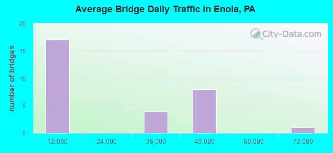
- 580,115Total average daily traffic
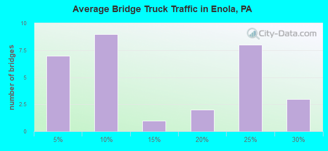
- 119,173Total average daily truck traffic
- National Bridge Inventory (NBI) Registered Bridges for Enola
- No street view available for this location
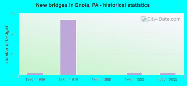
- New bridges - historical statistics
- 11960-1969
- 271970-1979
- 11990-1999
- 12000-2009
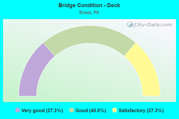
- Bridge Condition - Deck
- 27.3%Very good
- 45.5%Good
- 27.3%Satisfactory
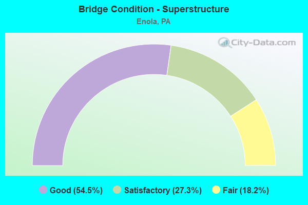
- Bridge Condition - Superstructure
- 54.5%Good
- 27.3%Satisfactory
- 18.2%Fair
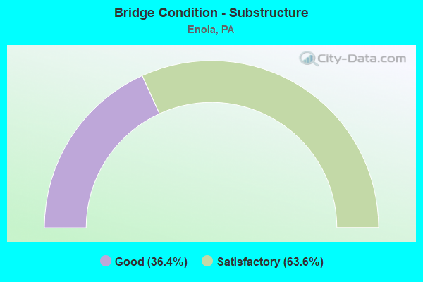
- Bridge Condition - Substructure
- 36.4%Good
- 63.6%Satisfactory
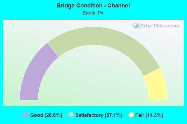
- Bridge Condition - Channel
- 28.6%Good
- 57.1%Satisfactory
- 14.3%Fair
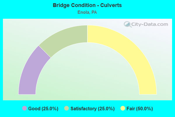
- Bridge Condition - Culverts
- 25.0%Good
- 25.0%Satisfactory
- 50.0%Fair
Find on map >> Show street view
Structure Number: 13594, Location: .5 MI.N. L.R. 21051 (Lat: 40.316306, Lng: -76.920592), Route carried "on" structure: US 11, Year Built: 1972, Status: Open, Structure Length: 9.20m (30.18ft), Average Daily Traffic: 8,493 (year 2021), Truck Traffic: 6%, Average Future Daily Traffic: 11,826 (year 2032), Design Load: HS 20, Features Intersected: I 81; SR 0081,COLL/DIST
Minimum Vertical Clearance: 30+ m (98+ ft), Kilometerpoint: 67.242, Lanes on structure: 2, Lanes under structure: 10, Base Highway Network: Yes, Owner: State Highway Agency, Approaching Roadway Width: 14.6m (47.9ft), Skew: 10 degrees, Material/Design: Prestressed concrete, Design/Construction: Box Beam or Girders - Multiple, Number Of Spans In Main Unit: 1, Number Of Approach Spans: 5, Length of Maximum Span: 19.8m (65.0ft), Curb or Sidewalk Widths: Left: 0.2m (0.7ft), Right: 0.2m (0.7ft), Curb-To-Curb Width: 17.2m (56.4ft), Out-to-Out Width: 18.4m (60.4ft)
Condition: Deck: Good, Superstructure: Fair, Substructure: Satisfactory, Operating Rating: 68.9 metric tons, Method Used To Determine Operating Rating: Load Factor (LF), Inventory Rating: 24.5 metric tons, Method Used To Determine Inventory Rating: Load Factor (LF), Structural Evaluation: Somewhat better than minimum adequacy, Deck Geometry: Superior to present desirable criteria, Underclear: High priority of corrective action, Approach Roadway Alignment: Equal to present desirable criteria, Length Of Structure Improvement: 10.20m (33.46ft), Designated Inspection Frequency: Every 24 months, Inspection Date: May 2020, Bridge Improvement Cost: $30,000, Roadway Improvement Cost: $89,000, Total Project Cost: $408,000, Deck Structure Type: Concrete Cast-file-Place, Wearing Surface/Protective System: Wearing Surface: Latex Concrete
Find on map >> Show street view
Structure Number: 13597, Location: SUMMERDALE (Lat: 40.316444, Lng: -76.920961), Route carried "on" structure: US 11, Year Built: 1972, Status: Open, Structure Length: 9.78m (32.09ft), Average Daily Traffic: 8,493 (year 2021), Truck Traffic: 6%, Average Future Daily Traffic: 11,826 (year 2032), Design Load: HS 20, Features Intersected: I-81; SR 0081, COLL/DIST
Minimum Vertical Clearance: 30+ m (98+ ft), Kilometerpoint: 67.229, Lanes on structure: 10, Lanes under structure: 10, Base Highway Network: Yes, Owner: State Highway Agency, Approaching Roadway Width: 16.5m (54.1ft), Skew: 10 degrees, Material/Design: Prestressed concrete, Design/Construction: Box Beam or Girders - Single/Spread, Number Of Spans In Main Unit: 6, Length of Maximum Span: 20.7m (67.9ft), Curb or Sidewalk Widths: Left: 0.2m (0.7ft), Right: 0.2m (0.7ft), Curb-To-Curb Width: 17.7m (58.1ft), Out-to-Out Width: 18.9m (62.0ft)
Condition: Deck: Good, Superstructure: Satisfactory, Substructure: Satisfactory, Operating Rating: 64.4 metric tons, Method Used To Determine Operating Rating: Load Factor (LF), Inventory Rating: 23.6 metric tons, Method Used To Determine Inventory Rating: Load Factor (LF), Structural Evaluation: Somewhat better than minimum adequacy, Deck Geometry: High priority of replacement, Underclear: High priority of corrective action, Approach Roadway Alignment: Equal to present desirable criteria, Length Of Structure Improvement: 10.80m (35.43ft), Designated Inspection Frequency: Every 24 months, Inspection Date: May 2020, Bridge Improvement Cost: $236,000, Roadway Improvement Cost: $695,000, Total Project Cost: $3,187,000, Deck Structure Type: Concrete Cast-file-Place, Wearing Surface/Protective System: Wearing Surface: Latex Concrete
Find on map >> Show street view
Structure Number: 13709, Location: 0.8 MI.W. OF LR 569 (Lat: 40.280850, Lng: -76.982778), Route carried "on" structure: Interstate 81, Year Built: 1973, Status: Open, Structure Length: 0.61m (2.00ft), Average Daily Traffic: 37,106 (year 2021), Truck Traffic: 20%, Average Future Daily Traffic: 48,785 (year 2032), Design Load: HS 20, Features Intersected: SEARS RUN
Minimum Vertical Clearance: 30+ m (98+ ft), Kilometerpoint: 55.056, Lanes on structure: 3, Base Highway Network: Yes, Owner: State Highway Agency, Approaching Roadway Width: 22.3m (73.2ft), Skew: 10 degrees, Material/Design: Concrete, Design/Construction: Culvert, Number Of Spans In Main Unit: 1, Length of Maximum Span: 6.1m (20.0ft)
Condition: Channel: Satisfactory, Culverts: Good, Operating Rating: 69.9 metric tons, Method Used To Determine Operating Rating: Field evaluation and documented engineering judgment, Inventory Rating: 46.3 metric tons, Method Used To Determine Inventory Rating: Field evaluation and documented engineering judgment, Structural Evaluation: Better than present minimum criteria, Waterway Adequacy: Superior to present desirable criteria, Approach Roadway Alignment: Equal to present desirable criteria, Length Of Structure Improvement: 1.20m (3.94ft), Designated Inspection Frequency: Every 24 months, Inspection Date: May 2020
Find on map >> Show street view
Structure Number: 1371, Location: 0.8 MI.W. L.R. 569 (Lat: 40.280908, Lng: -76.984072), Route carried "on" structure: Interstate 81, Year Built: 1973, Status: Open, Structure Length: 0.61m (2.00ft), Average Daily Traffic: 38,853 (year 2021), Truck Traffic: 19%, Average Future Daily Traffic: 47,705 (year 2032), Design Load: HS 20, Features Intersected: SEARS RUN
Minimum Vertical Clearance: 30+ m (98+ ft), Kilometerpoint: 54.883, Lanes on structure: 3, Base Highway Network: Yes, Owner: State Highway Agency, Approaching Roadway Width: 22.3m (73.2ft), Skew: 11 degrees, Material/Design: Concrete, Design/Construction: Culvert, Number Of Spans In Main Unit: 1, Length of Maximum Span: 6.1m (20.0ft)
Condition: Channel: Good, Culverts: Satisfactory, Operating Rating: 69.9 metric tons, Method Used To Determine Operating Rating: Field evaluation and documented engineering judgment, Inventory Rating: 46.3 metric tons, Method Used To Determine Inventory Rating: Field evaluation and documented engineering judgment, Structural Evaluation: Equal to present minimum criteria, Waterway Adequacy: Superior to present desirable criteria, Approach Roadway Alignment: Equal to present desirable criteria, Length Of Structure Improvement: 1.20m (3.94ft), Designated Inspection Frequency: Every 24 months, Inspection Date: May 2020
Find on map >> Show street view
Structure Number: 13713, Location: 2 MI. S. US 11 & 15 (Lat: 40.305269, Lng: -76.956139), Route carried "on" structure: State highway , Year Built: 1973, Status: Open, Structure Length: 7.38m (24.21ft), Average Daily Traffic: 932 (year 2022), Truck Traffic: 7%, Average Future Daily Traffic: 1,198 (year 2032), Design Load: HS 20, Features Intersected: I-81 NB; SR 0081, Facility Carried by Structure: T-664; TOWER RD
Minimum Vertical Clearance: 30+ m (98+ ft), Kilometerpoint: 0.000, Lanes on structure: 2, Lanes under structure: 3, Owner: State Highway Agency, Approaching Roadway Width: 13.4m (44.0ft), Material/Design: Steel, Design/Construction: Stringer/Multi-beam, Number Of Spans In Main Unit: 1, Number Of Approach Spans: 2, Length of Maximum Span: 34.4m (112.9ft), Curb or Sidewalk Widths: Left: 0.2m (0.7ft), Right: 0.2m (0.7ft), Curb-To-Curb Width: 13.4m (44.0ft), Out-to-Out Width: 14.6m (47.9ft)
Condition: Deck: Good, Superstructure: Good, Substructure: Good, Inventory Rating: 53.5 metric tons, Method Used To Determine Inventory Rating: Load Factor (LF), Structural Evaluation: Better than present minimum criteria, Deck Geometry: Superior to present desirable criteria, Underclear: Superior to present desirable criteria, Approach Roadway Alignment: Equal to present desirable criteria, Length Of Structure Improvement: 8.40m (27.56ft), Designated Inspection Frequency: Every 24 months, Inspection Date: May 2020, Deck Structure Type: Concrete Cast-file-Place, Wearing Surface/Protective System: Wearing Surface: Latex Concrete
Find on map >> Show street view
Structure Number: 13714, Location: 1.7 MI.S. SR 0011 (Lat: 40.306381, Lng: -76.956558), Route carried "on" structure: State highway , Year Built: 1973, Status: Open, Structure Length: 5.64m (18.50ft), Average Daily Traffic: 932 (year 2022), Truck Traffic: 7%, Average Future Daily Traffic: 1,198 (year 2032), Design Load: HS 20, Features Intersected: I-81 SB; SR 0081, Facility Carried by Structure: T-664; TOWER RD
Minimum Vertical Clearance: 30+ m (98+ ft), Kilometerpoint: 0.074, Lanes on structure: 2, Lanes under structure: 3, Owner: State Highway Agency, Approaching Roadway Width: 14.0m (45.9ft), Material/Design: Prestressed concrete, Design/Construction: Stringer/Multi-beam, Number Of Spans In Main Unit: 3, Length of Maximum Span: 29.9m (98.1ft), Curb or Sidewalk Widths: Left: 0.2m (0.7ft), Right: 0.2m (0.7ft), Curb-To-Curb Width: 13.4m (44.0ft), Out-to-Out Width: 14.6m (47.9ft)
Condition: Deck: Good, Superstructure: Good, Substructure: Satisfactory, Operating Rating: 68.0 metric tons, Method Used To Determine Operating Rating: Load Factor (LF), Inventory Rating: 18.1 metric tons, Method Used To Determine Inventory Rating: Load Factor (LF), Structural Evaluation: Somewhat better than minimum adequacy, Deck Geometry: Superior to present desirable criteria, Underclear: Somewhat better than minimum adequacy, Approach Roadway Alignment: Equal to present desirable criteria, Length Of Structure Improvement: 6.60m (21.65ft), Designated Inspection Frequency: Every 24 months, Inspection Date: May 2020, Bridge Improvement Cost: $23,000, Roadway Improvement Cost: $68,000, Total Project Cost: $311,000, Deck Structure Type: Concrete Cast-file-Place, Wearing Surface/Protective System: Wearing Surface: Monolithic Concrete
Find on map >> Show street view
Structure Number: 13853, Location: S OF MT ZION HAMDEN TWP (Lat: 40.276556, Lng: -76.986831), Route carried "on" structure: State highway , Year Built: 1973, Status: Open, Structure Length: 5.73m (18.80ft), Average Daily Traffic: 4,457 (year 2022), Truck Traffic: 2%, Average Future Daily Traffic: 5,525 (year 2032), Design Load: HS 20, Features Intersected: I-81 NB; SR 0081, Facility Carried by Structure: 1013 Good Hope Rd
Minimum Vertical Clearance: 30+ m (98+ ft), Kilometerpoint: 5.644, Lanes on structure: 2, Lanes under structure: 3, Owner: State Highway Agency, Approaching Roadway Width: 14.6m (47.9ft), Skew: 2 degrees, Material/Design: Prestressed concrete, Design/Construction: Stringer/Multi-beam, Number Of Spans In Main Unit: 1, Number Of Approach Spans: 2, Length of Maximum Span: 28.7m (94.2ft), Curb or Sidewalk Widths: Left: 0.2m (0.7ft), Right: 0.2m (0.7ft), Curb-To-Curb Width: 13.4m (44.0ft), Out-to-Out Width: 14.6m (47.9ft)
Condition: Deck: Very good, Superstructure: Good, Substructure: Good, Operating Rating: 72.6 metric tons, Method Used To Determine Operating Rating: Load Factor (LF), Inventory Rating: 24.5 metric tons, Method Used To Determine Inventory Rating: Load Factor (LF), Structural Evaluation: Equal to present minimum criteria, Deck Geometry: Better than present minimum criteria, Underclear: Equal to present minimum criteria, Approach Roadway Alignment: Equal to present desirable criteria, Length Of Structure Improvement: 6.70m (21.98ft), Designated Inspection Frequency: Every 24 months, Inspection Date: April 2020, Deck Structure Type: Concrete Cast-file-Place, Wearing Surface/Protective System: Wearing Surface: Latex Concrete
Find on map >> Show street view
Structure Number: 13854, Location: .5 MI. S. OF L.R. 569 (Lat: 40.277692, Lng: -76.987050), Route carried "on" structure: State highway , Year Built: 1973, Status: Open, Structure Length: 6.61m (21.69ft), Average Daily Traffic: 4,457 (year 2022), Truck Traffic: 2%, Average Future Daily Traffic: 5,525 (year 2032), Design Load: HS 20, Features Intersected: I-81 SB; SR 0081, Facility Carried by Structure: 1013 Good Hope Rd
Minimum Vertical Clearance: 30+ m (98+ ft), Kilometerpoint: 5.644, Lanes on structure: 2, Lanes under structure: 3, Owner: State Highway Agency, Approaching Roadway Width: 13.4m (44.0ft), Skew: 2 degrees, Material/Design: Prestressed concrete, Design/Construction: Stringer/Multi-beam, Number Of Spans In Main Unit: 1, Number Of Approach Spans: 2, Length of Maximum Span: 35.7m (117.1ft), Curb or Sidewalk Widths: Left: 0.2m (0.7ft), Right: 0.2m (0.7ft), Curb-To-Curb Width: 13.4m (44.0ft), Out-to-Out Width: 14.6m (47.9ft)
Condition: Deck: Good, Superstructure: Good, Substructure: Good, Operating Rating: 68.9 metric tons, Method Used To Determine Operating Rating: Load Factor (LF), Inventory Rating: 19.1 metric tons, Method Used To Determine Inventory Rating: Load Factor (LF), Structural Evaluation: Somewhat better than minimum adequacy, Deck Geometry: Better than present minimum criteria, Underclear: Somewhat better than minimum adequacy, Approach Roadway Alignment: Equal to present desirable criteria, Length Of Structure Improvement: 7.60m (24.93ft), Designated Inspection Frequency: Every 24 months, Inspection Date: April 2020, Bridge Improvement Cost: $53,000, Roadway Improvement Cost: $155,000, Total Project Cost: $711,000, Deck Structure Type: Concrete Cast-file-Place, Wearing Surface/Protective System: Wearing Surface: Latex Concrete
Find on map >> Show street view
Structure Number: 13855, Location: .2 MI.N. I-81 (Lat: 40.280528, Lng: -76.986911), Route carried "on" structure: State highway , Year Built: 1973, Status: Open, Structure Length: 0.85m (2.79ft), Average Daily Traffic: 4,457 (year 2022), Truck Traffic: 2%, Average Future Daily Traffic: 5,525 (year 2032), Design Load: HS 20, Features Intersected: SEARS RUN, Facility Carried by Structure: SR 1013
Minimum Vertical Clearance: 30+ m (98+ ft), Kilometerpoint: 6.326, Lanes on structure: 2, Owner: State Highway Agency, Approaching Roadway Width: 9.8m (32.2ft), Skew: 4 degrees, Material/Design: Concrete, Design/Construction: Culvert, Number Of Spans In Main Unit: 1, Length of Maximum Span: 8.5m (27.9ft)
Condition: Channel: Satisfactory, Culverts: Fair, Operating Rating: 69.9 metric tons, Method Used To Determine Operating Rating: Allowable Stress (AS), Inventory Rating: 46.3 metric tons, Method Used To Determine Inventory Rating: Allowable Stress (AS), Structural Evaluation: Somewhat better than minimum adequacy, Waterway Adequacy: Superior to present desirable criteria, Approach Roadway Alignment: Equal to present desirable criteria, Length Of Structure Improvement: 1.30m (4.27ft), Designated Inspection Frequency: Every 24 months, Inspection Date: May 2020
Find on map >> Show street view
Structure Number: 14037, Location: 1.6 W W.FRVW/CONODGUINET (Lat: 40.277183, Lng: -76.949756), Route carried "on" structure: City street , Year Built: 1966, Status: Open, Structure Length: 10.00m (32.81ft), Average Daily Traffic: 678 (year 2021), Truck Traffic: 1%, Average Future Daily Traffic: 904 (year 2041), Design Load: H 20, Features Intersected: CONODOGUINET CREEK, Facility Carried by Structure: BRIDGE ROAD
Minimum Vertical Clearance: 30+ m (98+ ft), Kilometerpoint: 0.000, Lanes on structure: 2, Owner: County Highway Agency, Approaching Roadway Width: 9.1m (29.9ft), Material/Design: Prestressed concrete, Design/Construction: Box Beam or Girders - Single/Spread, Number Of Spans In Main Unit: 5, Length of Maximum Span: 19.8m (65.0ft), Curb or Sidewalk Widths: Left: 0.5m (1.6ft), Right: 1.5m (4.9ft), Curb-To-Curb Width: 9.1m (29.9ft), Out-to-Out Width: 11.8m (38.7ft)
Condition: Deck: Satisfactory, Superstructure: Fair, Substructure: Satisfactory, Channel: Fair, Operating Rating: 36.3 metric tons, Method Used To Determine Operating Rating: Field evaluation and documented engineering judgment, Inventory Rating: 32.7 metric tons, Method Used To Determine Inventory Rating: Field evaluation and documented engineering judgment, Structural Evaluation: Somewhat better than minimum adequacy, Deck Geometry: Equal to present minimum criteria, Waterway Adequacy: Superior to present desirable criteria, Approach Roadway Alignment: Equal to present desirable criteria, Length Of Structure Improvement: 10.90m (35.76ft), Designated Inspection Frequency: Every 24 months, Inspection Date: September 2021, Deck Structure Type: Concrete Cast-file-Place, Wearing Surface/Protective System: Wearing Surface: Latex Concrete
Find on map >> Show street view
Structure Number: 14039, Location: .2W WEST FAIRVW/TR.CONODG (Lat: 40.276339, Lng: -76.931208), Route carried "on" structure: City street , Year Built: 1995, Status: Open, Structure Length: 0.82m (2.69ft), Average Daily Traffic: 2,219 (year 2021), Truck Traffic: 10%, Average Future Daily Traffic: 2,500 (year 2041), Design Load: HS 25 or greater, Features Intersected: POSSUM HOLLOW CREEK, Facility Carried by Structure: CREEKSIDE DRIVE
Minimum Vertical Clearance: 30+ m (98+ ft), Kilometerpoint: 0.000, Lanes on structure: 2, Owner: Town or Township Highway Agency, Approaching Roadway Width: 9.8m (32.2ft), Skew: 1 degrees, Material/Design: Wood or Timber, Design/Construction: Stringer/Multi-beam, Number Of Spans In Main Unit: 1, Length of Maximum Span: 7.6m (24.9ft), Curb-To-Curb Width: 9.8m (32.2ft), Out-to-Out Width: 10.4m (34.1ft)
Condition: Deck: Very good, Superstructure: Good, Substructure: Good, Channel: Satisfactory, Operating Rating: 59.0 metric tons, Method Used To Determine Operating Rating: Allowable Stress (AS), Inventory Rating: 42.6 metric tons, Method Used To Determine Inventory Rating: Allowable Stress (AS), Structural Evaluation: Better than present minimum criteria, Deck Geometry: Meets minimum limits, Waterway Adequacy: Superior to present desirable criteria, Approach Roadway Alignment: Better than present minimum criteria, Length Of Structure Improvement: 0.80m (2.62ft), Designated Inspection Frequency: Every 24 months, Inspection Date: September 2021, Bridge Improvement Cost: $15,000, Roadway Improvement Cost: $60,000, Total Project Cost: $249,000, Deck Structure Type: Wood or Timber, Wearing Surface/Protective System: Wearing Surface: Bituminous, Membrane: Preformed Fabric
Find on map >> Show street view
Structure Number: 14214, Location: HARRISBURG (WADE BR) (Lat: 40.316167, Lng: -76.917853), Route carried "on" structure: Interstate 81, Year Built: 1973, Year Reconstructed: 2013, Status: Open, Structure Length: 158.13m (518.80ft), Average Daily Traffic: 66,415 (year 2022), Truck Traffic: 25%, Average Future Daily Traffic: 83,950 (year 2040), Design Load: HS 20, Features Intersected: SR 3009;SUSQ RIV; NSRCRR
Minimum Vertical Clearance: 30+ m (98+ ft), Kilometerpoint: 0.000, Lanes on structure: 6, Lanes under structure: 3, Base Highway Network: Yes, Owner: State Highway Agency, Approaching Roadway Width: 64.0m (210.0ft), Skew: 30 degrees, Material/Design: Steel continuous, Design/Construction: Girder and Floorbeam System, Number Of Spans In Main Unit: 34, Number Of Approach Spans: 10, Length of Maximum Span: 41.5m (136.2ft), Curb or Sidewalk Widths: Left: 0.2m (0.7ft), Right: 0.2m (0.7ft), Curb-To-Curb Width: 31.1m (102.0ft), Out-to-Out Width: 35.4m (116.1ft)
Condition: Deck: Very good, Superstructure: Good, Substructure: Satisfactory, Channel: Satisfactory, Operating Rating: 38.1 metric tons, Method Used To Determine Operating Rating: Load Factor (LF), Inventory Rating: 22.7 metric tons, Method Used To Determine Inventory Rating: Load Factor (LF), Structural Evaluation: Somewhat better than minimum adequacy, Deck Geometry: Superior to present desirable criteria, Underclear: Meets minimum limits, Waterway Adequacy: Superior to present desirable criteria, Approach Roadway Alignment: Equal to present desirable criteria, Length Of Structure Improvement: 160.50m (526.57ft), Designated Inspection Frequency: Every 24 months, Critical Feature Inspection Frequency: Every 24 months, Underwater Inspection Frequency: Every 60 months, Inspection Date: September 2020, Critical Feature Inspection Date: September 2020, Underwater Inspection Date: July 2019, Bridge Improvement Cost: $250,000, Total Project Cost: $30,068,000, Deck Structure Type: Concrete Cast-file-Place, Wearing Surface/Protective System: Wearing Surface: Latex Concrete
Find on map >> Show street view
Structure Number: 4221, Location: .2W FRVW/TR.CONDGNT CREEK (Lat: 40.278947, Lng: -76.933175), Route carried "on" structure: City street , Year Built: 2003, Status: Open, Structure Length: 0.82m (2.69ft), Average Daily Traffic: 300 (year 2021), Truck Traffic: 1%, Average Future Daily Traffic: 420 (year 2041), Design Load: HS 25 or greater, Features Intersected: TRIB.CONODOGUINET CREEK, Facility Carried by Structure: MAGARO ROAD
Minimum Vertical Clearance: 30+ m (98+ ft), Kilometerpoint: 0.000, Lanes on structure: 2, Owner: Town or Township Highway Agency, Approaching Roadway Width: 4.6m (15.1ft), Skew: 5 degrees, Material/Design: Concrete, Design/Construction: Culvert, Number Of Spans In Main Unit: 1, Length of Maximum Span: 8.2m (26.9ft), Curb-To-Curb Width: 7.3m (24.0ft), Out-to-Out Width: 7.3m (24.0ft)
Condition: Channel: Good, Culverts: Fair, Operating Rating: 88.0 metric tons, Method Used To Determine Operating Rating: Load Factor (LF), Inventory Rating: 52.6 metric tons, Method Used To Determine Inventory Rating: Load Factor (LF), Structural Evaluation: Somewhat better than minimum adequacy, Deck Geometry: Somewhat better than minimum adequacy, Waterway Adequacy: Better than present minimum criteria, Approach Roadway Alignment: Equal to present desirable criteria, Length Of Structure Improvement: 1.40m (4.59ft), Designated Inspection Frequency: Every 24 months, Inspection Date: September 2021
Find on map >> Show street view
Structure Number: 45015, Location: I-81 SB Ramp to US11 NB (Lat: 40.316597, Lng: -76.917250), Route carried "on" structure: Ramp State highway , Year Built: 1972, Status: Open, Structure Length: 4.24m (13.91ft), Average Daily Traffic: 2,413 (year 2022), Truck Traffic: 3%, Average Future Daily Traffic: 3,023 (year 2032), Design Load: HS 20, Features Intersected: Norfolk Southern RR Prop, Facility Carried by Structure: Ramp C
Minimum Vertical Clearance: 30+ m (98+ ft), Kilometerpoint: 0.000, Lanes on structure: 1, Base Highway Network: Yes, Owner: State Highway Agency, Approaching Roadway Width: 7.9m (25.9ft), Skew: 9 degrees, Material/Design: Steel continuous, Design/Construction: Stringer/Multi-beam, Number Of Spans In Main Unit: 2, Length of Maximum Span: 22.6m (74.1ft), Curb or Sidewalk Widths: Left: 0.2m (0.7ft), Right: 0.2m (0.7ft), Curb-To-Curb Width: 6.7m (22.0ft), Out-to-Out Width: 7.9m (25.9ft)
Condition: Deck: Satisfactory, Superstructure: Satisfactory, Substructure: Satisfactory, Operating Rating: 53.5 metric tons, Method Used To Determine Operating Rating: Load Factor (LF), Inventory Rating: 31.8 metric tons, Method Used To Determine Inventory Rating: Load Factor (LF), Structural Evaluation: Equal to present minimum criteria, Deck Geometry: Equal to present minimum criteria, Underclear: High priority of corrective action, Approach Roadway Alignment: Better than present minimum criteria, Designated Inspection Frequency: Every 24 months, Inspection Date: September 2020, Deck Structure Type: Concrete Cast-file-Place, Wearing Surface/Protective System: Wearing Surface: Latex Concrete
Find on map >> Show street view
Structure Number: 45016, Location: US 11NB to I-81 NB Ramp B (Lat: 40.315806, Lng: -76.918056), Route carried "on" structure: Ramp State highway , Year Built: 1972, Status: Open, Structure Length: 4.45m (14.60ft), Average Daily Traffic: 6,428 (year 2022), Truck Traffic: 2%, Average Future Daily Traffic: 7,881 (year 2032), Design Load: HS 20, Features Intersected: Norfolk Southern RR Prop, Facility Carried by Structure: Ramp B
Minimum Vertical Clearance: 30+ m (98+ ft), Kilometerpoint: 0.000, Lanes on structure: 1, Base Highway Network: Yes, Owner: State Highway Agency, Approaching Roadway Width: 7.9m (25.9ft), Skew: 9 degrees, Material/Design: Steel continuous, Design/Construction: Stringer/Multi-beam, Number Of Spans In Main Unit: 2, Length of Maximum Span: 21.9m (71.9ft), Curb or Sidewalk Widths: Left: 0.2m (0.7ft), Right: 0.2m (0.7ft), Curb-To-Curb Width: 6.7m (22.0ft), Out-to-Out Width: 7.9m (25.9ft)
Condition: Deck: Satisfactory, Superstructure: Satisfactory, Substructure: Satisfactory, Operating Rating: 48.1 metric tons, Method Used To Determine Operating Rating: Load Factor (LF), Inventory Rating: 28.1 metric tons, Method Used To Determine Inventory Rating: Load Factor (LF), Structural Evaluation: Equal to present minimum criteria, Deck Geometry: Equal to present minimum criteria, Underclear: High priority of corrective action, Approach Roadway Alignment: Equal to present minimum criteria, Designated Inspection Frequency: Every 24 months, Inspection Date: September 2020, Deck Structure Type: Concrete Cast-file-Place, Wearing Surface/Protective System: Wearing Surface: Latex Concrete
Find on map >> Show street view
Structure Number: 13594, Location: .5 MI.N. L.R. 21051 (Lat: 40.316306, Lng: -76.920592), Route carried "under" structure: Interstate 81, Year Built: 1972, Structure Length: 0. m, Average Daily Traffic: 34,771 (year 2022), Truck Traffic: 25%, Features Intersected: I 81; SR 0081,COLL/DIST, Facility Carried by Structure: US 11 NB; SR 0011
Minimum Vertical Clearance: 5.08m (16.67ft), Kilometerpoint: 62.301, Lanes on structure: 2, Lanes under structure: 3, Material/Design: Prestressed concrete, Design/Construction: Box Beam or Girders - Multiple, Length of Maximum Span: 19.8m (65.0ft)
Find on map >> Show street view
Structure Number: 13594, Location: .5 MI.N. L.R. 21051 (Lat: 40.316306, Lng: -76.920592), Route carried "under" structure: Interstate 81, Year Built: 1972, Structure Length: 0. m, Average Daily Traffic: 31,644 (year 2022), Truck Traffic: 24%, Features Intersected: I 81; SR 0081,COLL/DIST, Facility Carried by Structure: US 11 NB; SR 0011
Minimum Vertical Clearance: 5.08m (16.67ft), Kilometerpoint: 62.209, Lanes on structure: 2, Lanes under structure: 3, Material/Design: Prestressed concrete, Design/Construction: Box Beam or Girders - Multiple, Length of Maximum Span: 19.8m (65.0ft)
Find on map >> Show street view
Structure Number: 13594, Location: .5 MI.N. L.R. 21051 (Lat: 40.316306, Lng: -76.920592), Route carried "under" structure: Ramp State highway , Year Built: 1972, Structure Length: 0. m, Average Daily Traffic: 5,201 (year 2022), Truck Traffic: 7%, Features Intersected: I 81; SR 0081,COLL/DIST, Facility Carried by Structure: US 11 NB; SR 0011
Minimum Vertical Clearance: 4.44m (14.57ft), Kilometerpoint: 0.000, Lanes on structure: 2, Lanes under structure: 2, Material/Design: Prestressed concrete, Design/Construction: Box Beam or Girders - Multiple, Length of Maximum Span: 19.8m (65.0ft)
Find on map >> Show street view
Structure Number: 13594, Location: .5 MI.N. L.R. 21051 (Lat: 40.316306, Lng: -76.920592), Route carried "under" structure: Ramp State highway , Year Built: 1972, Structure Length: 0. m, Average Daily Traffic: 3,433 (year 2022), Truck Traffic: 7%, Features Intersected: I 81; SR 0081,COLL/DIST, Facility Carried by Structure: US 11 NB; SR 0011
Minimum Vertical Clearance: 6.07m (19.91ft), Kilometerpoint: 0.000, Lanes on structure: 2, Lanes under structure: 2, Material/Design: Prestressed concrete, Design/Construction: Box Beam or Girders - Multiple, Length of Maximum Span: 19.8m (65.0ft)
Find on map >> Show street view
Structure Number: 13597, Location: SUMMERDALE (Lat: 40.316444, Lng: -76.920961), Route carried "under" structure: Interstate 81, Year Built: 1972, Structure Length: 0. m, Average Daily Traffic: 31,644 (year 2022), Truck Traffic: 24%, Features Intersected: I-81; SR 0081, COLL/DIST, Facility Carried by Structure: US 11 SB; SR 0011
Minimum Vertical Clearance: 5.43m (17.81ft), Kilometerpoint: 62.209, Lanes on structure: 10, Lanes under structure: 3, Material/Design: Prestressed concrete, Design/Construction: Box Beam or Girders - Single/Spread, Length of Maximum Span: 20.7m (67.9ft)
Find on map >> Show street view
Structure Number: 13597, Location: SUMMERDALE (Lat: 40.316444, Lng: -76.920961), Route carried "under" structure: Ramp State highway , Year Built: 1972, Structure Length: 0. m, Average Daily Traffic: 5,201 (year 2022), Truck Traffic: 7%, Features Intersected: I-81; SR 0081, COLL/DIST, Facility Carried by Structure: US 11 SB; SR 0011
Minimum Vertical Clearance: 4.78m (15.68ft), Kilometerpoint: 0.000, Lanes on structure: 10, Lanes under structure: 2, Material/Design: Prestressed concrete, Design/Construction: Box Beam or Girders - Single/Spread, Length of Maximum Span: 20.7m (67.9ft)
Find on map >> Show street view
Structure Number: 13597, Location: SUMMERDALE (Lat: 40.316444, Lng: -76.920961), Route carried "under" structure: Interstate 81, Year Built: 1972, Structure Length: 0. m, Average Daily Traffic: 34,771 (year 2022), Truck Traffic: 25%, Features Intersected: I-81; SR 0081, COLL/DIST, Facility Carried by Structure: US 11 SB; SR 0011
Minimum Vertical Clearance: 5.69m (18.67ft), Kilometerpoint: 62.301, Lanes on structure: 10, Lanes under structure: 3, Material/Design: Prestressed concrete, Design/Construction: Box Beam or Girders - Single/Spread, Length of Maximum Span: 20.7m (67.9ft)
Find on map >> Show street view
Structure Number: 13597, Location: SUMMERDALE (Lat: 40.316444, Lng: -76.920961), Route carried "under" structure: Ramp State highway , Year Built: 1972, Structure Length: 0. m, Average Daily Traffic: 3,433 (year 2022), Truck Traffic: 7%, Features Intersected: I-81; SR 0081, COLL/DIST, Facility Carried by Structure: US 11 SB; SR 0011
Minimum Vertical Clearance: 6.55m (21.49ft), Kilometerpoint: 0.000, Lanes on structure: 10, Lanes under structure: 2, Material/Design: Prestressed concrete, Design/Construction: Box Beam or Girders - Single/Spread, Length of Maximum Span: 20.7m (67.9ft)
Find on map >> Show street view
Structure Number: 13713, Location: 2 MI. S. US 11 & 15 (Lat: 40.305269, Lng: -76.956139), Route carried "under" structure: Interstate 81, Year Built: 1973, Structure Length: 0. m, Average Daily Traffic: 39,904 (year 2021), Truck Traffic: 23%, Features Intersected: I-81 NB; SR 0081, Facility Carried by Structure: T-664; TOWER RD
Minimum Vertical Clearance: 8.00m (26.25ft), Kilometerpoint: 59.092, Lanes on structure: 2, Lanes under structure: 3, Material/Design: Steel, Design/Construction: Stringer/Multi-beam, Length of Maximum Span: 34.4m (112.9ft)
Find on map >> Show street view
Structure Number: 13714, Location: 1.7 MI.S. SR 0011 (Lat: 40.306381, Lng: -76.956558), Route carried "under" structure: Interstate 81, Year Built: 1973, Structure Length: 0. m, Average Daily Traffic: 40,381 (year 2021), Truck Traffic: 23%, Features Intersected: I-81 SB; SR 0081, Facility Carried by Structure: T-664; TOWER RD
Minimum Vertical Clearance: 5.11m (16.77ft), Kilometerpoint: 58.992, Lanes on structure: 2, Lanes under structure: 3, Material/Design: Prestressed concrete, Design/Construction: Stringer/Multi-beam, Length of Maximum Span: 29.9m (98.1ft)
Find on map >> Show street view
Structure Number: 1381, Location: MT.ZION (Lat: 40.289103, Lng: -76.982333), Route carried "under" structure: Interstate 81, Year Built: 1973, Structure Length: 0. m, Average Daily Traffic: 39,904 (year 2021), Truck Traffic: 23%, Features Intersected: I-81; SR 0081, Facility Carried by Structure: 944 Wertzville Rd
Minimum Vertical Clearance: 4.93m (16.17ft), Kilometerpoint: 55.867, Lanes on structure: 4, Lanes under structure: 6, Material/Design: Prestressed concrete, Design/Construction: Stringer/Multi-beam, Length of Maximum Span: 31.4m (103.0ft)
Find on map >> Show street view
Structure Number: 1381, Location: MT.ZION (Lat: 40.289103, Lng: -76.982333), Route carried "under" structure: Interstate 81, Year Built: 1973, Structure Length: 0. m, Average Daily Traffic: 40,381 (year 2021), Truck Traffic: 23%, Features Intersected: I-81; SR 0081, Facility Carried by Structure: 944 Wertzville Rd
Minimum Vertical Clearance: 4.93m (16.17ft), Kilometerpoint: 55.712, Lanes on structure: 4, Lanes under structure: 6, Material/Design: Prestressed concrete, Design/Construction: Stringer/Multi-beam, Length of Maximum Span: 31.4m (103.0ft)
Find on map >> Show street view
Structure Number: 13853, Location: S OF MT ZION HAMDEN TWP (Lat: 40.276556, Lng: -76.986831), Route carried "under" structure: Interstate 81, Year Built: 1973, Structure Length: 0. m, Average Daily Traffic: 37,106 (year 2021), Truck Traffic: 20%, Features Intersected: I-81 NB; SR 0081, Facility Carried by Structure: 1013 Good Hope Rd
Minimum Vertical Clearance: 5.08m (16.67ft), Kilometerpoint: 54.264, Lanes on structure: 2, Lanes under structure: 3, Material/Design: Prestressed concrete, Design/Construction: Stringer/Multi-beam, Length of Maximum Span: 28.7m (94.2ft)
Find on map >> Show street view
Structure Number: 13854, Location: .5 MI. S. OF L.R. 569 (Lat: 40.277692, Lng: -76.987050), Route carried "under" structure: Interstate 81, Year Built: 1973, Structure Length: 0. m, Average Daily Traffic: 38,853 (year 2021), Truck Traffic: 19%, Features Intersected: I-81 SB; SR 0081, Facility Carried by Structure: 1013 Good Hope Rd
Minimum Vertical Clearance: 4.95m (16.24ft), Kilometerpoint: 54.883, Lanes on structure: 2, Lanes under structure: 3, Material/Design: Prestressed concrete, Design/Construction: Stringer/Multi-beam, Length of Maximum Span: 35.7m (117.1ft)
Find on map >> Show street view
Structure Number: 14214, Location: HARRISBURG (WADE BR) (Lat: 40.316167, Lng: -76.917853), Route carried "under" structure: State highway , Year Built: 1973, Structure Length: 0. m, Average Daily Traffic: 6,855 (year 2020), Truck Traffic: 6%, Features Intersected: SR 3009;SUSQ RIV; NSRCRR, Facility Carried by Structure: I-81; SR 0081
Minimum Vertical Clearance: 4.42m (14.50ft), Kilometerpoint: 7.791, Lanes on structure: 6, Lanes under structure: 3, Material/Design: Steel continuous, Design/Construction: Girder and Floorbeam System, Length of Maximum Span: 41.5m (136.2ft)