Bridge Statistics for Enterprise, Mississippi (MS)
Condition, Traffic, Stress, Structural Evaluation, Project Costs
- National Bridge Inventory (NBI) Statistics
- 43Number of bridges
- 646ft / 197mTotal length
- $5,864,680,000Total costs
- 144,290Total average daily traffic
- 39,973Total average daily truck traffic
- National Bridge Inventory (NBI) Registered Bridges for Enterprise
- No street view available for this location
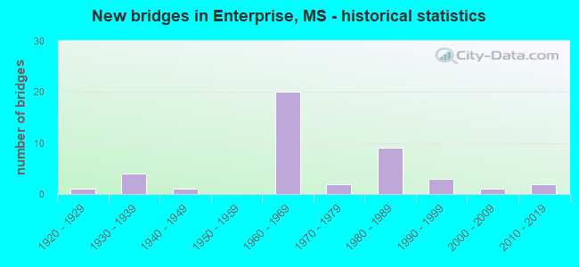
- New bridges - historical statistics
- 11920-1929
- 41930-1939
- 11940-1949
- 201960-1969
- 21970-1979
- 91980-1989
- 31990-1999
- 12000-2009
- 22010-2019


- Bridge Condition - Deck
- 17.9%Very good
- 46.4%Good
- 17.9%Satisfactory
- 14.3%Fair
- 3.6%Poor

- Bridge Condition - Superstructure
- 21.4%Very good
- 50.0%Good
- 7.1%Satisfactory
- 21.4%Fair

- Bridge Condition - Substructure
- 25.0%Very good
- 50.0%Good
- 17.9%Satisfactory
- 3.6%Fair
- 3.6%Poor

- Bridge Condition - Channel
- 10.7%Very good
- 39.3%Good
- 39.3%Satisfactory
- 7.1%Fair
- 3.6%Poor

- Bridge Condition - Culverts
- 77.8%Good
- 22.2%Satisfactory
Find on map >> Show street view
Structure Number: 11000590121332A, Location: I 59 OVER SR 513 (Lat: 32.163914, Lng: -88.867700), Route carried "on" structure: Interstate 59, Year Built: 1965, Status: Open, Structure Length: 5.55m (18.21ft), Average Daily Traffic: 6,500 (year 2020), Truck Traffic: 35%, Average Future Daily Traffic: 7,000 (year 2040), Design Load: HS 20+Mod, Features Intersected: SR 513
Minimum Vertical Clearance: 30+ m (98+ ft), Kilometerpoint: 7.654, Lanes on structure: 2, Lanes under structure: 2, Base Highway Network: Yes (Inventory Route: 5, Subroute: 1), Owner: State Highway Agency, Approaching Roadway Width: 12.8m (42.0ft), Material/Design: Prestressed concrete, Design/Construction: Stringer/Multi-beam, Number Of Spans In Main Unit: 3, Length of Maximum Span: 18.3m (60.0ft), Curb-To-Curb Width: 12.8m (42.0ft), Out-to-Out Width: 13.7m (44.9ft)
Condition: Deck: Satisfactory, Superstructure: Good, Substructure: Good, Operating Rating: 72.6 metric tons, Method Used To Determine Operating Rating: Load Factor (LF), Inventory Rating: 43.4 metric tons, Method Used To Determine Inventory Rating: Load Factor (LF), Structural Evaluation: Better than present minimum criteria, Deck Geometry: Equal to present desirable criteria, Underclear: Meets minimum limits, Approach Roadway Alignment: Equal to present desirable criteria, Length Of Structure Improvement: 5.55m (18.21ft), Designated Inspection Frequency: Every 24 months, Inspection Date: Febuary 2021, Bridge Improvement Cost: $191,000,000, Roadway Improvement Cost: $130,000,000, Total Project Cost: $321,000,000, Deck Structure Type: Concrete Cast-file-Place
Find on map >> Show street view
Structure Number: 11000590121332B, Location: I 59 OVER SR 513 (Lat: 32.163528, Lng: -88.867089), Route carried "on" structure: Interstate 59, Year Built: 1965, Status: Open, Structure Length: 5.55m (18.21ft), Average Daily Traffic: 6,500 (year 2020), Truck Traffic: 35%, Average Future Daily Traffic: 7,000 (year 2040), Design Load: HS 20+Mod, Features Intersected: SR 513
Minimum Vertical Clearance: 30+ m (98+ ft), Kilometerpoint: 13.567, Lanes on structure: 2, Lanes under structure: 2, Base Highway Network: Yes (Inventory Route: 5, Subroute: 1), Owner: State Highway Agency, Approaching Roadway Width: 12.8m (42.0ft), Material/Design: Prestressed concrete, Design/Construction: Stringer/Multi-beam, Number Of Spans In Main Unit: 3, Length of Maximum Span: 18.3m (60.0ft), Curb-To-Curb Width: 12.8m (42.0ft), Out-to-Out Width: 13.0m (42.7ft)
Condition: Deck: Good, Superstructure: Satisfactory, Substructure: Good, Operating Rating: 72.6 metric tons, Method Used To Determine Operating Rating: Load Factor (LF), Inventory Rating: 43.4 metric tons, Method Used To Determine Inventory Rating: Load Factor (LF), Structural Evaluation: Equal to present minimum criteria, Deck Geometry: Equal to present desirable criteria, Underclear: Meets minimum limits, Approach Roadway Alignment: Equal to present desirable criteria, Length Of Structure Improvement: 5.55m (18.21ft), Designated Inspection Frequency: Every 24 months, Inspection Date: Febuary 2021, Bridge Improvement Cost: $191,000,000, Roadway Improvement Cost: $130,000,000, Total Project Cost: $321,000,000, Deck Structure Type: Concrete Cast-file-Place
Find on map >> Show street view
Structure Number: 11000590121339A, Location: 0.7 MI N SR 513 (Lat: 32.174211, Lng: -88.866611), Route carried "on" structure: Interstate 59, Year Built: 1965, Status: Open, Structure Length: 1.10m (3.61ft), Average Daily Traffic: 7,000 (year 2020), Truck Traffic: 35%, Average Future Daily Traffic: 7,500 (year 2040), Design Load: HS 20, Features Intersected: STREAM
Minimum Vertical Clearance: 30+ m (98+ ft), Kilometerpoint: 6.508, Lanes on structure: 2, Base Highway Network: Yes (Inventory Route: 5, Subroute: 1), Owner: State Highway Agency, Approaching Roadway Width: 13.4m (44.0ft), Skew: 1 degrees, Material/Design: Concrete, Design/Construction: Culvert, Number Of Spans In Main Unit: 2, Length of Maximum Span: 4.9m (16.1ft)
Condition: Channel: Good, Culverts: Good, Structural Evaluation: Better than present minimum criteria, Waterway Adequacy: Equal to present desirable criteria, Approach Roadway Alignment: Equal to present desirable criteria, Designated Inspection Frequency: Every 24 months, Inspection Date: January 2021
Find on map >> Show street view
Structure Number: 11000590121339B, Location: 0.7 MI N SR 513 (Lat: 32.173747, Lng: -88.866058), Route carried "on" structure: Interstate 59, Year Built: 1965, Status: Open, Structure Length: 1.10m (3.61ft), Average Daily Traffic: 7,000 (year 2020), Truck Traffic: 37%, Average Future Daily Traffic: 7,500 (year 2040), Design Load: HS 20+Mod, Features Intersected: STREAM
Minimum Vertical Clearance: 30+ m (98+ ft), Kilometerpoint: 14.705, Lanes on structure: 2, Base Highway Network: Yes (Inventory Route: 5, Subroute: 1), Owner: State Highway Agency, Approaching Roadway Width: 62.2m (204.1ft), Material/Design: Concrete, Design/Construction: Culvert, Number Of Spans In Main Unit: 2, Length of Maximum Span: 4.9m (16.1ft)
Condition: Channel: Satisfactory, Culverts: Good, Operating Rating: 40.5 metric tons, Method Used To Determine Operating Rating: Load Factor (LF), Inventory Rating: 24.3 metric tons, Method Used To Determine Inventory Rating: Load Factor (LF), Structural Evaluation: Equal to present minimum criteria, Waterway Adequacy: Equal to present desirable criteria, Approach Roadway Alignment: Equal to present desirable criteria, Designated Inspection Frequency: Every 24 months, Inspection Date: January 2021
Find on map >> Show street view
Structure Number: 11000590121345A, Location: 1.3 MI N SR 513 (Lat: 32.182011, Lng: -88.861819), Route carried "on" structure: Interstate 59, Year Built: 1965, Status: Open, Structure Length: 4.72m (15.49ft), Average Daily Traffic: 7,000 (year 2020), Truck Traffic: 35%, Average Future Daily Traffic: 7,500 (year 2040), Design Load: HS 20+Mod, Features Intersected: COUNTY ROAD 360
Minimum Vertical Clearance: 30+ m (98+ ft), Kilometerpoint: 5.520, Lanes on structure: 2, Lanes under structure: 2, Base Highway Network: Yes (Inventory Route: 5, Subroute: 1), Owner: State Highway Agency, Approaching Roadway Width: 12.8m (42.0ft), Material/Design: Prestressed concrete, Design/Construction: Stringer/Multi-beam, Number Of Spans In Main Unit: 3, Length of Maximum Span: 15.5m (50.9ft), Curb-To-Curb Width: 12.8m (42.0ft), Out-to-Out Width: 13.7m (44.9ft)
Condition: Deck: Good, Superstructure: Good, Substructure: Good, Operating Rating: 74.0 metric tons, Method Used To Determine Operating Rating: Load Factor (LF), Inventory Rating: 42.1 metric tons, Method Used To Determine Inventory Rating: Load Factor (LF), Structural Evaluation: Better than present minimum criteria, Deck Geometry: Equal to present desirable criteria, Underclear: Better than present minimum criteria, Approach Roadway Alignment: Equal to present desirable criteria, Length Of Structure Improvement: 4.72m (15.49ft), Designated Inspection Frequency: Every 24 months, Inspection Date: Febuary 2021, Bridge Improvement Cost: $163,000,000, Roadway Improvement Cost: $130,000,000, Total Project Cost: $293,000,000, Deck Structure Type: Concrete Cast-file-Place
Find on map >> Show street view
Structure Number: 11000590121345B, Location: 1.3 MI N SR 513 (Lat: 32.181453, Lng: -88.861708), Route carried "on" structure: Interstate 59, Year Built: 1965, Status: Open, Structure Length: 4.72m (15.49ft), Average Daily Traffic: 7,000 (year 2020), Truck Traffic: 37%, Average Future Daily Traffic: 7,500 (year 2040), Design Load: HS 20+Mod, Features Intersected: COUNTY ROAD 360
Minimum Vertical Clearance: 30+ m (98+ ft), Kilometerpoint: 15.665, Lanes on structure: 2, Lanes under structure: 2, Base Highway Network: Yes (Inventory Route: 5, Subroute: 1), Owner: State Highway Agency, Approaching Roadway Width: 12.8m (42.0ft), Material/Design: Prestressed concrete, Design/Construction: Stringer/Multi-beam, Number Of Spans In Main Unit: 3, Length of Maximum Span: 15.5m (50.9ft), Curb-To-Curb Width: 12.8m (42.0ft), Out-to-Out Width: 13.7m (44.9ft)
Condition: Deck: Good, Superstructure: Good, Substructure: Good, Operating Rating: 75.7 metric tons, Method Used To Determine Operating Rating: Load Factor (LF), Inventory Rating: 42.1 metric tons, Method Used To Determine Inventory Rating: Load Factor (LF), Structural Evaluation: Better than present minimum criteria, Deck Geometry: Equal to present desirable criteria, Underclear: Better than present minimum criteria, Approach Roadway Alignment: Equal to present desirable criteria, Length Of Structure Improvement: 4.72m (15.49ft), Designated Inspection Frequency: Every 24 months, Inspection Date: Febuary 2021, Bridge Improvement Cost: $163,000,000, Roadway Improvement Cost: $130,000,000, Total Project Cost: $293,000,000, Deck Structure Type: Concrete Cast-file-Place
Find on map >> Show street view
Structure Number: 1100059012135, Location: 1.8 MI N SR 513 (Lat: 32.186672, Lng: -88.856778), Route carried "on" structure: Interstate 59, Year Built: 1965, Status: Open, Structure Length: 0.94m (3.08ft), Average Daily Traffic: 14,000 (year 2020), Truck Traffic: 37%, Average Future Daily Traffic: 15,000 (year 2040), Design Load: HS 20, Features Intersected: ALLEN BRANCH
Minimum Vertical Clearance: 30+ m (98+ ft), Kilometerpoint: 16.407, Lanes on structure: 4, Base Highway Network: Yes (Inventory Route: 5, Subroute: 1), Owner: State Highway Agency, Approaching Roadway Width: 48.8m (160.1ft), Skew: 1 degrees, Material/Design: Concrete, Design/Construction: Culvert, Number Of Spans In Main Unit: 2, Length of Maximum Span: 4.3m (14.1ft)
Condition: Channel: Good, Culverts: Satisfactory, Structural Evaluation: Equal to present minimum criteria, Waterway Adequacy: Equal to present desirable criteria, Approach Roadway Alignment: Equal to present desirable criteria, Length Of Structure Improvement: 0.94m (3.08ft), Designated Inspection Frequency: Every 24 months, Inspection Date: January 2021, Bridge Improvement Cost: $140,000,000, Roadway Improvement Cost: $200,000,000, Total Project Cost: $340,000,000
Find on map >> Show street view
Structure Number: 11000590121365A, Location: 1.5 MI S LAUDERDALE CL (Lat: 32.205264, Lng: -88.843667), Route carried "on" structure: Interstate 59, Year Built: 1965, Status: Open, Structure Length: 6.80m (22.31ft), Average Daily Traffic: 7,000 (year 2020), Truck Traffic: 35%, Average Future Daily Traffic: 7,500 (year 2040), Design Load: HS 20+Mod, Features Intersected: COUNTY ROAD 370
Minimum Vertical Clearance: 30+ m (98+ ft), Kilometerpoint: 2.414, Lanes on structure: 2, Lanes under structure: 2, Base Highway Network: Yes (Inventory Route: 5, Subroute: 1), Owner: State Highway Agency, Approaching Roadway Width: 12.8m (42.0ft), Material/Design: Prestressed concrete, Design/Construction: Stringer/Multi-beam, Number Of Spans In Main Unit: 2, Number Of Approach Spans: 2, Length of Maximum Span: 18.3m (60.0ft), Curb-To-Curb Width: 12.8m (42.0ft), Out-to-Out Width: 13.7m (44.9ft)
Condition: Deck: Good, Superstructure: Good, Substructure: Good, Operating Rating: 72.6 metric tons, Method Used To Determine Operating Rating: Load Factor (LF), Inventory Rating: 43.4 metric tons, Method Used To Determine Inventory Rating: Load Factor (LF), Structural Evaluation: Better than present minimum criteria, Deck Geometry: Equal to present desirable criteria, Underclear: Meets minimum limits, Approach Roadway Alignment: Equal to present desirable criteria, Length Of Structure Improvement: 6.80m (22.31ft), Designated Inspection Frequency: Every 24 months, Inspection Date: Febuary 2021, Bridge Improvement Cost: $234,000,000, Roadway Improvement Cost: $130,000,000, Total Project Cost: $364,000,000, Deck Structure Type: Concrete Cast-file-Place
Find on map >> Show street view
Structure Number: 11000590121365B, Location: 1.5 MI S LAUDERDALE CL (Lat: 32.204622, Lng: -88.843806), Route carried "on" structure: Interstate 59, Year Built: 1965, Status: Open, Structure Length: 6.80m (22.31ft), Average Daily Traffic: 7,000 (year 2020), Truck Traffic: 37%, Average Future Daily Traffic: 7,500 (year 2040), Design Load: HS 20+Mod, Features Intersected: COUNTY ROAD 370
Minimum Vertical Clearance: 30+ m (98+ ft), Kilometerpoint: 18.749, Lanes on structure: 2, Lanes under structure: 2, Base Highway Network: Yes (Inventory Route: 5, Subroute: 1), Owner: State Highway Agency, Approaching Roadway Width: 12.8m (42.0ft), Material/Design: Prestressed concrete, Design/Construction: Stringer/Multi-beam, Number Of Spans In Main Unit: 2, Number Of Approach Spans: 2, Length of Maximum Span: 18.3m (60.0ft), Curb-To-Curb Width: 12.8m (42.0ft), Out-to-Out Width: 13.7m (44.9ft)
Condition: Deck: Good, Superstructure: Good, Substructure: Good, Operating Rating: 72.6 metric tons, Method Used To Determine Operating Rating: Load Factor (LF), Inventory Rating: 43.4 metric tons, Method Used To Determine Inventory Rating: Load Factor (LF), Structural Evaluation: Better than present minimum criteria, Deck Geometry: Equal to present desirable criteria, Underclear: Meets minimum limits, Approach Roadway Alignment: Equal to present desirable criteria, Length Of Structure Improvement: 6.80m (22.31ft), Designated Inspection Frequency: Every 24 months, Inspection Date: Febuary 2021, Bridge Improvement Cost: $234,000,000, Roadway Improvement Cost: $130,000,000, Total Project Cost: $364,000,000, Deck Structure Type: Concrete Cast-file-Place
Find on map >> Show street view
Structure Number: 11000590121377, Location: 0.3 MI S LAUDERDALE CL (Lat: 32.221225, Lng: -88.833303), Route carried "on" structure: Interstate 59, Year Built: 1965, Status: Open, Structure Length: 0.82m (2.69ft), Average Daily Traffic: 13,000 (year 2020), Truck Traffic: 41%, Average Future Daily Traffic: 14,000 (year 2040), Design Load: HS 20, Features Intersected: STREAM
Minimum Vertical Clearance: 30+ m (98+ ft), Kilometerpoint: 20.852, Lanes on structure: 4, Base Highway Network: Yes (Inventory Route: 5, Subroute: 1), Owner: State Highway Agency, Approaching Roadway Width: 43.3m (142.1ft), Skew: 1 degrees, Material/Design: Concrete, Design/Construction: Culvert, Number Of Spans In Main Unit: 2, Length of Maximum Span: 3.7m (12.1ft)
Condition: Channel: Satisfactory, Culverts: Satisfactory, Inventory Rating: 74.7 metric tons, Method Used To Determine Inventory Rating: Load Factor (LF), Structural Evaluation: Equal to present minimum criteria, Waterway Adequacy: Equal to present desirable criteria, Approach Roadway Alignment: Equal to present desirable criteria, Length Of Structure Improvement: 0.82m (2.69ft), Designated Inspection Frequency: Every 24 months, Inspection Date: Febuary 2021, Bridge Improvement Cost: $121,000,000, Roadway Improvement Cost: $200,000,000, Total Project Cost: $321,000,000
Find on map >> Show street view
Structure Number: 11000590381382A, Location: 0.2 MI N CLARKE CL (Lat: 32.227631, Lng: -88.832764), Route carried "on" structure: Interstate 59, Year Built: 1965, Status: Open, Structure Length: 14.63m (48.00ft), Average Daily Traffic: 6,500 (year 2020), Truck Traffic: 34%, Average Future Daily Traffic: 7,500 (year 2040), Design Load: HS 20+Mod, Features Intersected: CHUNKY RIVER
Minimum Vertical Clearance: 30+ m (98+ ft), Kilometerpoint: 53.124, Lanes on structure: 2, Base Highway Network: Yes (Inventory Route: 5, Subroute: 1), Owner: State Highway Agency, Approaching Roadway Width: 13.4m (44.0ft), Material/Design: Concrete continuous, Design/Construction: Box Beam or Girders - Single/Spread, Number Of Spans In Main Unit: 3, Number Of Approach Spans: 6, Length of Maximum Span: 30.5m (100.1ft), Curb or Sidewalk Widths: Left: 0.5m (1.6ft), Right: 0.5m (1.6ft), Curb-To-Curb Width: 8.5m (27.9ft), Out-to-Out Width: 10.0m (32.8ft)
Condition: Deck: Good, Superstructure: Good, Substructure: Good, Channel: Good, Operating Rating: 74.2 metric tons, Method Used To Determine Operating Rating: Load Factor (LF), Inventory Rating: 44.4 metric tons, Method Used To Determine Inventory Rating: Load Factor (LF), Structural Evaluation: Better than present minimum criteria, Deck Geometry: High priority of corrective action, Waterway Adequacy: Equal to present desirable criteria, Approach Roadway Alignment: Equal to present desirable criteria, Length Of Structure Improvement: 14.63m (48.00ft), Designated Inspection Frequency: Every 24 months, Inspection Date: May 2021, Bridge Improvement Cost: $355,000,000, Roadway Improvement Cost: $200,000,000, Total Project Cost: $555,000,000, Deck Structure Type: Concrete Cast-file-Place
Find on map >> Show street view
Structure Number: 11000590381382B, Location: 0.2 MI N CLARKE CL (Lat: 32.226283, Lng: -88.832642), Route carried "on" structure: Interstate 59, Year Built: 1965, Status: Open, Structure Length: 14.63m (48.00ft), Average Daily Traffic: 6,500 (year 2020), Truck Traffic: 41%, Average Future Daily Traffic: 7,500 (year 2040), Design Load: HS 20+Mod, Features Intersected: CHUNKY RIVER
Minimum Vertical Clearance: 30+ m (98+ ft), Kilometerpoint: 0.172, Lanes on structure: 2, Base Highway Network: Yes (Inventory Route: 5, Subroute: 1), Owner: State Highway Agency, Approaching Roadway Width: 13.4m (44.0ft), Material/Design: Concrete continuous, Design/Construction: Box Beam or Girders - Single/Spread, Number Of Spans In Main Unit: 3, Number Of Approach Spans: 6, Length of Maximum Span: 30.5m (100.1ft), Curb or Sidewalk Widths: Left: 0.5m (1.6ft), Right: 0.5m (1.6ft), Curb-To-Curb Width: 8.5m (27.9ft), Out-to-Out Width: 10.0m (32.8ft)
Condition: Deck: Fair, Superstructure: Fair, Substructure: Very good, Channel: Good, Operating Rating: 74.2 metric tons, Method Used To Determine Operating Rating: Load Factor (LF), Inventory Rating: 44.4 metric tons, Method Used To Determine Inventory Rating: Load Factor (LF), Structural Evaluation: Somewhat better than minimum adequacy, Deck Geometry: High priority of corrective action, Waterway Adequacy: Equal to present desirable criteria, Approach Roadway Alignment: Equal to present desirable criteria, Length Of Structure Improvement: 14.63m (48.00ft), Designated Inspection Frequency: Every 24 months, Inspection Date: May 2021, Bridge Improvement Cost: $355,000,000, Roadway Improvement Cost: $200,000,000, Total Project Cost: $555,000,000, Deck Structure Type: Concrete Cast-file-Place
Find on map >> Show street view
Structure Number: 17000590121365A, Location: 1.5 MI S LAUDERDALE CL (Lat: 32.204656, Lng: -88.845114), Route carried "on" structure: Ramp Interstate 59, Year Built: 1981, Status: Open, Structure Length: 0.79m (2.59ft), Average Daily Traffic: 110 (year 2020), Truck Traffic: 26%, Average Future Daily Traffic: 120 (year 2040), Design Load: HS 20+Mod, Features Intersected: STREAM, Facility Carried by Structure: RAMP
Minimum Vertical Clearance: 30+ m (98+ ft), Kilometerpoint: 0.116, Lanes on structure: 1, Owner: State Highway Agency, Approaching Roadway Width: 8.5m (27.9ft), Skew: 3 degrees, Material/Design: Concrete, Design/Construction: Culvert, Number Of Spans In Main Unit: 2, Length of Maximum Span: 3.7m (12.1ft)
Condition: Channel: Satisfactory, Culverts: Good, Structural Evaluation: Better than present minimum criteria, Waterway Adequacy: Equal to present desirable criteria, Approach Roadway Alignment: Equal to present desirable criteria, Designated Inspection Frequency: Every 24 months, Inspection Date: January 2021
Find on map >> Show street view
Structure Number: 17000590121365B, Location: 1.5 MI S LAUDERDALE CL (Lat: 32.204061, Lng: -88.842678), Route carried "on" structure: Ramp Interstate 59, Year Built: 1981, Status: Open, Structure Length: 0.79m (2.59ft), Average Daily Traffic: 90 (year 2020), Truck Traffic: 26%, Average Future Daily Traffic: 100 (year 2040), Design Load: HS 20+Mod, Features Intersected: STREAM, Facility Carried by Structure: RAMP
Minimum Vertical Clearance: 30+ m (98+ ft), Kilometerpoint: 0.496, Lanes on structure: 1, Owner: State Highway Agency, Approaching Roadway Width: 16.8m (55.1ft), Skew: 3 degrees, Material/Design: Concrete, Design/Construction: Culvert, Number Of Spans In Main Unit: 2, Length of Maximum Span: 3.7m (12.1ft)
Condition: Channel: Good, Culverts: Good, Operating Rating: 61.0 metric tons, Method Used To Determine Operating Rating: Load Factor (LF), Inventory Rating: 36.5 metric tons, Method Used To Determine Inventory Rating: Load Factor (LF), Structural Evaluation: Better than present minimum criteria, Waterway Adequacy: Equal to present desirable criteria, Approach Roadway Alignment: Equal to present desirable criteria, Designated Inspection Frequency: Every 24 months, Inspection Date: January 2021
Find on map >> Show street view
Structure Number: 21000110121405, Location: 3.8 MI S SR 513 (Lat: 32.122525, Lng: -88.854467), Route carried "on" structure: US 11, Year Built: 1942, Status: Posted for load, Structure Length: 3.69m (12.11ft), Average Daily Traffic: 610 (year 2020), Truck Traffic: 11%, Average Future Daily Traffic: 610 (year 2040), Design Load: H 15, Features Intersected: NORFOLK SOUTHERN RR
Minimum Vertical Clearance: 30+ m (98+ ft), Kilometerpoint: 19.491, Lanes on structure: 2, Owner: State Highway Agency, Approaching Roadway Width: 7.3m (24.0ft), Material/Design: Steel, Design/Construction: Stringer/Multi-beam, Number Of Spans In Main Unit: 3, Length of Maximum Span: 12.2m (40.0ft), Curb-To-Curb Width: 7.3m (24.0ft), Out-to-Out Width: 8.7m (28.5ft)
Condition: Deck: Satisfactory, Superstructure: Satisfactory, Substructure: Satisfactory, Operating Rating: 39.2 metric tons, Method Used To Determine Operating Rating: Load Factor (LF), Inventory Rating: 23.5 metric tons, Method Used To Determine Inventory Rating: Load Factor (LF), Structural Evaluation: Equal to present minimum criteria, Deck Geometry: Meets minimum limits, Underclear: Somewhat better than minimum adequacy, Approach Roadway Alignment: Better than present minimum criteria, Bridge Posting: Required (Relationship of Operating Rating to Maximum Legal Load: 0.1 - 9.9% below), Length Of Structure Improvement: 3.69m (12.11ft), Designated Inspection Frequency: Every 12 months, Inspection Date: May 2021, Bridge Improvement Cost: $113,000,000, Roadway Improvement Cost: $130,000,000, Total Project Cost: $243,000,000, Deck Structure Type: Concrete Cast-file-Place
Find on map >> Show street view
Structure Number: 21000110121429, Location: 1.4 MI S SR 513 (Lat: 32.154125, Lng: -88.842422), Route carried "on" structure: US 11, Year Built: 1925, Status: Open, Structure Length: 0.67m (2.20ft), Average Daily Traffic: 610 (year 2020), Truck Traffic: 11%, Average Future Daily Traffic: 610 (year 2040), Design Load: H 15, Features Intersected: STREAM
Minimum Vertical Clearance: 30+ m (98+ ft), Kilometerpoint: 23.373, Lanes on structure: 2, Owner: State Highway Agency, Approaching Roadway Width: 7.9m (25.9ft), Material/Design: Concrete, Design/Construction: Culvert, Number Of Spans In Main Unit: 2, Length of Maximum Span: 3.0m (9.8ft)
Condition: Channel: Satisfactory, Culverts: Good, Operating Rating: 88.1 metric tons, Method Used To Determine Operating Rating: Load Factor (LF), Inventory Rating: 52.8 metric tons, Method Used To Determine Inventory Rating: Load Factor (LF), Structural Evaluation: Better than present minimum criteria, Waterway Adequacy: Equal to present minimum criteria, Approach Roadway Alignment: Equal to present desirable criteria, Designated Inspection Frequency: Every 24 months, Inspection Date: May 2021
Find on map >> Show street view
Structure Number: 21000110121433, Location: 1.0 MI S SR 513 (Lat: 32.159586, Lng: -88.838994), Route carried "on" structure: US 11, Year Built: 1937, Status: Open, Structure Length: 1.83m (6.00ft), Average Daily Traffic: 610 (year 2020), Truck Traffic: 11%, Average Future Daily Traffic: 610 (year 2040), Design Load: H 15, Features Intersected: CANTS CREEK
Minimum Vertical Clearance: 30+ m (98+ ft), Kilometerpoint: 24.060, Lanes on structure: 2, Owner: State Highway Agency, Approaching Roadway Width: 7.3m (24.0ft), Material/Design: Steel, Design/Construction: Stringer/Multi-beam, Number Of Spans In Main Unit: 3, Length of Maximum Span: 6.1m (20.0ft), Curb-To-Curb Width: 7.3m (24.0ft), Out-to-Out Width: 8.0m (26.2ft)
Condition: Deck: Fair, Superstructure: Fair, Substructure: Fair, Channel: Satisfactory, Operating Rating: 43.6 metric tons, Method Used To Determine Operating Rating: Load Factor (LF), Inventory Rating: 26.1 metric tons, Method Used To Determine Inventory Rating: Load Factor (LF), Structural Evaluation: Somewhat better than minimum adequacy, Deck Geometry: Meets minimum limits, Waterway Adequacy: Equal to present minimum criteria, Approach Roadway Alignment: Equal to present desirable criteria, Length Of Structure Improvement: 1.83m (6.00ft), Designated Inspection Frequency: Every 24 months, Other Special Inspection Frequency: Every 24 months, Inspection Date: April 2021, Other Special Inspection Date: April 2020, Bridge Improvement Cost: $56,000,000, Roadway Improvement Cost: $130,000,000, Total Project Cost: $186,000,000, Deck Structure Type: Concrete Cast-file-Place
Find on map >> Show street view
Structure Number: 21000110121446, Location: 0.3 MI N SR 513 (Lat: 32.176169, Lng: -88.830089), Route carried "on" structure: US 11, Year Built: 1937, Status: Open, Structure Length: 2.74m (8.99ft), Average Daily Traffic: 1,700 (year 2020), Truck Traffic: 11%, Average Future Daily Traffic: 1,700 (year 2040), Design Load: H 15, Features Intersected: WEIR CREEK
Minimum Vertical Clearance: 30+ m (98+ ft), Kilometerpoint: 26.091, Lanes on structure: 2, Owner: State Highway Agency, Approaching Roadway Width: 7.9m (25.9ft), Material/Design: Steel, Design/Construction: Stringer/Multi-beam, Number Of Spans In Main Unit: 3, Length of Maximum Span: 9.1m (29.9ft), Curb-To-Curb Width: 7.3m (24.0ft), Out-to-Out Width: 8.3m (27.2ft)
Condition: Deck: Fair, Superstructure: Fair, Substructure: Satisfactory, Channel: Satisfactory, Operating Rating: 41.5 metric tons, Method Used To Determine Operating Rating: Load Factor (LF), Inventory Rating: 24.9 metric tons, Method Used To Determine Inventory Rating: Load Factor (LF), Structural Evaluation: Somewhat better than minimum adequacy, Deck Geometry: Meets minimum limits, Waterway Adequacy: Equal to present minimum criteria, Approach Roadway Alignment: Equal to present desirable criteria, Length Of Structure Improvement: 2.74m (8.99ft), Designated Inspection Frequency: Every 24 months, Inspection Date: May 2021, Bridge Improvement Cost: $84,000,000, Roadway Improvement Cost: $130,000,000, Total Project Cost: $214,000,000, Deck Structure Type: Concrete Cast-file-Place
Find on map >> Show street view
Structure Number: 21000110121452, Location: 0.9 MI N SR 513 (Lat: 32.183861, Lng: -88.828494), Route carried "on" structure: US 11, Year Built: 1937, Status: Open, Structure Length: 2.74m (8.99ft), Average Daily Traffic: 1,300 (year 2020), Truck Traffic: 11%, Average Future Daily Traffic: 1,300 (year 2040), Design Load: H 15, Features Intersected: ALLEN CREEK
Minimum Vertical Clearance: 30+ m (98+ ft), Kilometerpoint: 26.961, Lanes on structure: 2, Owner: State Highway Agency, Approaching Roadway Width: 8.5m (27.9ft), Material/Design: Steel, Design/Construction: Stringer/Multi-beam, Number Of Spans In Main Unit: 3, Length of Maximum Span: 9.1m (29.9ft), Curb-To-Curb Width: 7.3m (24.0ft), Out-to-Out Width: 8.3m (27.2ft)
Condition: Deck: Poor, Superstructure: Fair, Substructure: Satisfactory, Channel: Satisfactory, Operating Rating: 41.5 metric tons, Method Used To Determine Operating Rating: Load Factor (LF), Inventory Rating: 24.9 metric tons, Method Used To Determine Inventory Rating: Load Factor (LF), Structural Evaluation: Somewhat better than minimum adequacy, Deck Geometry: Meets minimum limits, Waterway Adequacy: Equal to present minimum criteria, Approach Roadway Alignment: Equal to present desirable criteria, Length Of Structure Improvement: 3.57m (11.71ft), Designated Inspection Frequency: Every 24 months, Inspection Date: May 2021, Bridge Improvement Cost: $84,000,000, Roadway Improvement Cost: $130,000,000, Total Project Cost: $214,000,000, Deck Structure Type: Concrete Cast-file-Place
Find on map >> Show street view
Structure Number: 21000110121458, Location: 1.3 MI N SR 513 (Lat: 32.191336, Lng: -88.825333), Route carried "on" structure: US 11, Year Built: 1994, Status: Open, Structure Length: 16.82m (55.18ft), Average Daily Traffic: 1,300 (year 2020), Truck Traffic: 11%, Average Future Daily Traffic: 1,300 (year 2040), Design Load: HS 20, Features Intersected: CHUNKY RIVER
Minimum Vertical Clearance: 30+ m (98+ ft), Kilometerpoint: 27.867, Lanes on structure: 2, Owner: State Highway Agency, Approaching Roadway Width: 13.4m (44.0ft), Material/Design: Prestressed concrete, Design/Construction: Stringer/Multi-beam, Number Of Spans In Main Unit: 1, Number Of Approach Spans: 11, Length of Maximum Span: 33.5m (109.9ft), Curb-To-Curb Width: 9.8m (32.2ft), Out-to-Out Width: 10.6m (34.8ft)
Condition: Deck: Good, Superstructure: Very good, Substructure: Good, Channel: Satisfactory, Operating Rating: 44.6 metric tons, Method Used To Determine Operating Rating: Load Factor (LF), Inventory Rating: 39.2 metric tons, Method Used To Determine Inventory Rating: Load Factor (LF), Structural Evaluation: Better than present minimum criteria, Deck Geometry: Somewhat better than minimum adequacy, Waterway Adequacy: Equal to present desirable criteria, Approach Roadway Alignment: Equal to present desirable criteria, Designated Inspection Frequency: Every 24 months, Inspection Date: May 2021, Deck Structure Type: Concrete Cast-file-Place
Find on map >> Show street view
Structure Number: 21000110121459, Location: 1.4 MI N SR 513 (Lat: 32.193325, Lng: -88.823814), Route carried "on" structure: US 11, Year Built: 1994, Status: Open, Structure Length: 11.03m (36.19ft), Average Daily Traffic: 1,300 (year 2020), Truck Traffic: 11%, Average Future Daily Traffic: 1,300 (year 2040), Design Load: HS 20, Features Intersected: CHUNKY RIVER RELIEF
Minimum Vertical Clearance: 30+ m (98+ ft), Kilometerpoint: 28.131, Lanes on structure: 2, Owner: State Highway Agency, Approaching Roadway Width: 13.4m (44.0ft), Skew: 4 degrees, Material/Design: Prestressed concrete, Design/Construction: Stringer/Multi-beam, Number Of Spans In Main Unit: 9, Length of Maximum Span: 12.2m (40.0ft), Curb-To-Curb Width: 9.8m (32.2ft), Out-to-Out Width: 10.6m (34.8ft)
Condition: Deck: Very good, Superstructure: Very good, Substructure: Very good, Channel: Good, Operating Rating: 49.1 metric tons, Method Used To Determine Operating Rating: Load Factor (LF), Inventory Rating: 42.3 metric tons, Method Used To Determine Inventory Rating: Load Factor (LF), Structural Evaluation: Equal to present desirable criteria, Deck Geometry: Somewhat better than minimum adequacy, Waterway Adequacy: Equal to present desirable criteria, Approach Roadway Alignment: Equal to present desirable criteria, Designated Inspection Frequency: Every 24 months, Inspection Date: May 2021, Deck Structure Type: Concrete Cast-file-Place
Find on map >> Show street view
Structure Number: 21000110121469, Location: 2.5 MI N SR 513 (Lat: 32.195989, Lng: -88.811239), Route carried "on" structure: US 11, Year Built: 2017, Status: Open, Structure Length: 11.02m (36.15ft), Average Daily Traffic: 1,300 (year 2020), Truck Traffic: 11%, Average Future Daily Traffic: 1,300 (year 2040), Design Load: HL 93, Features Intersected: CHUNKY RIVER RELIEF
Minimum Vertical Clearance: 30+ m (98+ ft), Kilometerpoint: 29.424, Lanes on structure: 2, Owner: State Highway Agency, Approaching Roadway Width: 13.4m (44.0ft), Material/Design: Prestressed concrete, Design/Construction: Stringer/Multi-beam, Number Of Spans In Main Unit: 9, Length of Maximum Span: 12.2m (40.0ft), Curb-To-Curb Width: 13.4m (44.0ft), Out-to-Out Width: 14.3m (46.9ft)
Condition: Deck: Very good, Superstructure: Very good, Substructure: Very good, Channel: Very good, Operating Rating: 48.3 metric tons, Method Used To Determine Operating Rating: Load and Resistance Factor (LRFR), Inventory Rating: 31.4 metric tons, Method Used To Determine Inventory Rating: Load and Resistance Factor (LRFR), Structural Evaluation: Better than present minimum criteria, Deck Geometry: Equal to present desirable criteria, Waterway Adequacy: Superior to present desirable criteria, Approach Roadway Alignment: Equal to present desirable criteria, Designated Inspection Frequency: Every 24 months, Underwater Inspection Frequency: Every 60 months, Inspection Date: May 2021, Underwater Inspection Date: April 2019, Deck Structure Type: Concrete Cast-file-Place
Find on map >> Show street view
Structure Number: 21000110121487, Location: 1.2 MI S LAUDERDALE CL (Lat: 32.213236, Lng: -88.787458), Route carried "on" structure: US 11, Year Built: 1937, Status: Posted for load, Structure Length: 1.83m (6.00ft), Average Daily Traffic: 1,300 (year 2020), Truck Traffic: 11%, Average Future Daily Traffic: 1,300 (year 2040), Design Load: H 15, Features Intersected: STREAM
Minimum Vertical Clearance: 30+ m (98+ ft), Kilometerpoint: 32.523, Lanes on structure: 2, Owner: State Highway Agency, Approaching Roadway Width: 7.3m (24.0ft), Material/Design: Steel, Design/Construction: Stringer/Multi-beam, Number Of Spans In Main Unit: 2, Length of Maximum Span: 9.1m (29.9ft), Curb-To-Curb Width: 7.3m (24.0ft), Out-to-Out Width: 8.0m (26.2ft)
Condition: Deck: Fair, Superstructure: Fair, Substructure: Satisfactory, Channel: Good, Operating Rating: 36.4 metric tons, Method Used To Determine Operating Rating: Load Factor (LF), Inventory Rating: 21.8 metric tons, Method Used To Determine Inventory Rating: Load Factor (LF), Structural Evaluation: Somewhat better than minimum adequacy, Deck Geometry: Meets minimum limits, Waterway Adequacy: Equal to present minimum criteria, Approach Roadway Alignment: Equal to present desirable criteria, Bridge Posting: Required (Relationship of Operating Rating to Maximum Legal Load: 10.0 - 19.9% below), Length Of Structure Improvement: 1.83m (6.00ft), Designated Inspection Frequency: Every 12 months, Inspection Date: May 2021, Bridge Improvement Cost: $56,000,000, Roadway Improvement Cost: $130,000,000, Total Project Cost: $186,000,000, Deck Structure Type: Concrete Cast-file-Place, Wearing Surface/Protective System: Wearing Surface: Bituminous
Find on map >> Show street view
Structure Number: 31005110120005, Location: 0.5 MI E SR 18 (Lat: 32.037539, Lng: -88.699931), Route carried "on" structure: State highway 511, Year Built: 1984, Status: Open, Structure Length: 1.16m (3.81ft), Average Daily Traffic: 2,200 (year 2020), Truck Traffic: 11%, Average Future Daily Traffic: 2,200 (year 2040), Design Load: HS 20, Features Intersected: STREAM
Minimum Vertical Clearance: 30+ m (98+ ft), Kilometerpoint: 9.727, Lanes on structure: 2, Owner: State Highway Agency, Approaching Roadway Width: 9.1m (29.9ft), Material/Design: Concrete, Design/Construction: Channel Beam, Number Of Spans In Main Unit: 2, Length of Maximum Span: 5.8m (19.0ft), Curb-To-Curb Width: 8.6m (28.2ft), Out-to-Out Width: 9.4m (30.8ft)
Condition: Deck: Good, Superstructure: Good, Substructure: Very good, Channel: Good, Operating Rating: 50.5 metric tons, Method Used To Determine Operating Rating: Load Factor (LF), Inventory Rating: 30.3 metric tons, Method Used To Determine Inventory Rating: Load Factor (LF), Structural Evaluation: Better than present minimum criteria, Deck Geometry: Meets minimum limits, Waterway Adequacy: Equal to present desirable criteria, Approach Roadway Alignment: Equal to present desirable criteria, Designated Inspection Frequency: Every 24 months, Inspection Date: May 2021, Deck Structure Type: Concrete Precast Panels
Find on map >> Show street view
Structure Number: 31005130120001, Location: 0.1 MI E US 11 (Lat: 32.176475, Lng: -88.828667), Route carried "on" structure: Spur State highway 513, Year Built: 1986, Status: Open, Structure Length: 2.32m (7.61ft), Average Daily Traffic: 1,500 (year 2020), Truck Traffic: 6%, Average Future Daily Traffic: 1,500 (year 2040), Design Load: HS 20, Features Intersected: STREAM
Minimum Vertical Clearance: 30+ m (98+ ft), Kilometerpoint: 0.135, Lanes on structure: 2, Owner: State Highway Agency, Approaching Roadway Width: 9.1m (29.9ft), Material/Design: Concrete, Design/Construction: Channel Beam, Number Of Spans In Main Unit: 4, Length of Maximum Span: 5.8m (19.0ft), Curb-To-Curb Width: 8.5m (27.9ft), Out-to-Out Width: 9.3m (30.5ft)
Condition: Deck: Very good, Superstructure: Very good, Substructure: Good, Channel: Fair, Operating Rating: 50.5 metric tons, Method Used To Determine Operating Rating: Load Factor (LF), Inventory Rating: 30.3 metric tons, Method Used To Determine Inventory Rating: Load Factor (LF), Structural Evaluation: Better than present minimum criteria, Deck Geometry: Somewhat better than minimum adequacy, Waterway Adequacy: Equal to present desirable criteria, Approach Roadway Alignment: Equal to present desirable criteria, Designated Inspection Frequency: Every 24 months, Inspection Date: May 2021, Deck Structure Type: Concrete Precast Panels
Find on map >> Show street view
Structure Number: 31005130120116, Location: 0.4 MI W SR 514 (Lat: 32.176200, Lng: -88.817269), Route carried "on" structure: State highway 513, Year Built: 1986, Status: Open, Structure Length: 29.63m (97.21ft), Average Daily Traffic: 3,200 (year 2020), Truck Traffic: 11%, Average Future Daily Traffic: 3,200 (year 2040), Design Load: HS 20, Features Intersected: CHICKASAWHAY RIVER
Minimum Vertical Clearance: 30+ m (98+ ft), Kilometerpoint: 18.413, Lanes on structure: 2, Owner: State Highway Agency, Approaching Roadway Width: 13.4m (44.0ft), Material/Design: Prestressed concrete, Design/Construction: Stringer/Multi-beam, Number Of Spans In Main Unit: 2, Number Of Approach Spans: 10, Length of Maximum Span: 32.0m (105.0ft), Curb or Sidewalk Widths: Left: 2.4m (7.9ft), Right: 2.4m (7.9ft), Curb-To-Curb Width: 12.2m (40.0ft), Out-to-Out Width: 13.1m (43.0ft)
Condition: Deck: Very good, Superstructure: Very good, Substructure: Very good, Channel: Satisfactory, Operating Rating: 40.3 metric tons, Method Used To Determine Operating Rating: Load Factor (LF), Inventory Rating: 34.6 metric tons, Method Used To Determine Inventory Rating: Load Factor (LF), Structural Evaluation: Equal to present desirable criteria, Deck Geometry: Equal to present minimum criteria, Waterway Adequacy: Equal to present desirable criteria, Approach Roadway Alignment: Equal to present desirable criteria, Designated Inspection Frequency: Every 24 months, Inspection Date: May 2021, Deck Structure Type: Concrete Cast-file-Place
Find on map >> Show street view
Structure Number: 41000590121305, Location: 2.7 MI S SR 513 (Lat: 32.125011, Lng: -88.875061), Route carried "on" structure: County highway , Year Built: 1966, Status: Open, Structure Length: 7.99m (26.21ft), Average Daily Traffic: 70 (year 2020), Truck Traffic: 8%, Average Future Daily Traffic: 70 (year 2040), Design Load: H 15, Features Intersected: I 59, Facility Carried by Structure: COUNTY ROAD 330
Minimum Vertical Clearance: 30+ m (98+ ft), Kilometerpoint: 3.257, Lanes on structure: 2, Lanes under structure: 4, Owner: State Highway Agency, Approaching Roadway Width: 11.0m (36.1ft), Material/Design: Prestressed concrete, Design/Construction: Stringer/Multi-beam, Number Of Spans In Main Unit: 2, Number Of Approach Spans: 2, Length of Maximum Span: 21.3m (69.9ft), Curb-To-Curb Width: 7.3m (24.0ft), Out-to-Out Width: 8.8m (28.9ft)
Condition: Deck: Good, Superstructure: Good, Substructure: Very good, Operating Rating: 58.4 metric tons, Method Used To Determine Operating Rating: Load Factor (LF), Inventory Rating: 29.3 metric tons, Method Used To Determine Inventory Rating: Load Factor (LF), Structural Evaluation: Better than present minimum criteria, Deck Geometry: Equal to present minimum criteria, Underclear: Meets minimum limits, Approach Roadway Alignment: Equal to present desirable criteria, Length Of Structure Improvement: 7.99m (26.21ft), Designated Inspection Frequency: Every 24 months, Inspection Date: Febuary 2021, Bridge Improvement Cost: $253,000,000, Roadway Improvement Cost: $200,000,000, Total Project Cost: $526,000,000, Deck Structure Type: Concrete Cast-file-Place
Find on map >> Show street view
Structure Number: 41000590121353, Location: 2.1 MI N SR 513 (Lat: 32.190453, Lng: -88.853014), Route carried "on" structure: County highway , Year Built: 1965, Status: Open, Structure Length: 9.11m (29.89ft), Average Daily Traffic: 170 (year 2020), Truck Traffic: 8%, Average Future Daily Traffic: 170 (year 2040), Design Load: HS 15, Features Intersected: I 59, Facility Carried by Structure: COUNTY ROAD 371
Minimum Vertical Clearance: 30+ m (98+ ft), Kilometerpoint: 1.672, Lanes on structure: 2, Lanes under structure: 4, Owner: State Highway Agency, Approaching Roadway Width: 11.0m (36.1ft), Material/Design: Concrete continuous, Design/Construction: Box Beam or Girders - Single/Spread, Number Of Spans In Main Unit: 2, Number Of Approach Spans: 2, Length of Maximum Span: 25.9m (85.0ft), Curb-To-Curb Width: 7.3m (24.0ft), Out-to-Out Width: 8.8m (28.9ft)
Condition: Deck: Good, Superstructure: Good, Substructure: Good, Operating Rating: 78.4 metric tons, Method Used To Determine Operating Rating: Load Factor (LF), Inventory Rating: 46.9 metric tons, Method Used To Determine Inventory Rating: Load Factor (LF), Structural Evaluation: Better than present minimum criteria, Deck Geometry: Somewhat better than minimum adequacy, Underclear: Somewhat better than minimum adequacy, Approach Roadway Alignment: Equal to present desirable criteria, Length Of Structure Improvement: 9.11m (29.89ft), Designated Inspection Frequency: Every 24 months, Inspection Date: Febuary 2021, Bridge Improvement Cost: $289,000,000, Roadway Improvement Cost: $200,000,000, Total Project Cost: $568,000,000, Deck Structure Type: Concrete Cast-file-Place
Find on map >> Show street view
Structure Number: SA1200000000001, Location: SEC 1 T 1N R14E B (Lat: 31.954522, Lng: -88.811500), Route carried "on" structure: County highway 342, Year Built: 1974, Status: Open, Structure Length: 1.74m (5.71ft), Average Daily Traffic: 570 (year 2021), Truck Traffic: 8%, Average Future Daily Traffic: 855 (year 2041), Design Load: H 15, Features Intersected: BOGUE HOMA CREEK, Facility Carried by Structure: CO RD 280
Minimum Vertical Clearance: 30+ m (98+ ft), Kilometerpoint: 10.782, Lanes on structure: 2, Owner: County Highway Agency, Approaching Roadway Width: 6.7m (22.0ft), Material/Design: Concrete, Design/Construction: Channel Beam, Number Of Spans In Main Unit: 3, Length of Maximum Span: 5.8m (19.0ft), Curb or Sidewalk Widths: Left: 0.2m (0.7ft), Right: 0.2m (0.7ft), Curb-To-Curb Width: 7.1m (23.3ft), Out-to-Out Width: 7.5m (24.6ft)
Condition: Deck: Good, Superstructure: Good, Substructure: Poor, Channel: Fair, Operating Rating: 36.2 metric tons, Method Used To Determine Operating Rating: Load Factor (LF), Inventory Rating: 21.7 metric tons, Method Used To Determine Inventory Rating: Load Factor (LF), Structural Evaluation: Meets minimum limits, Deck Geometry: Meets minimum limits, Waterway Adequacy: Equal to present desirable criteria, Approach Roadway Alignment: Equal to present desirable criteria, Length Of Structure Improvement: 2.38m (7.81ft), Designated Inspection Frequency: Every 12 months, Inspection Date: October 2021, Bridge Improvement Cost: $280,000, Roadway Improvement Cost: $50,000, Total Project Cost: $330,000 ( Estimate for 2021), Deck Structure Type: Concrete Precast Panels, Wearing Surface/Protective System: Wearing Surface: Bituminous
Find on map >> Show street view
Structure Number: SA1200000000104, Location: SEC 11 T 4N R14E B (Lat: 32.202694, Lng: -88.841139), Route carried "on" structure: County highway 974, Year Built: 2005, Status: Open, Structure Length: 0.81m (2.66ft), Average Daily Traffic: 600 (year 2021), Truck Traffic: 8%, Average Future Daily Traffic: 900 (year 2041), Design Load: HS 20, Features Intersected: KIDD BRANCH, Facility Carried by Structure: CO RD 370
Minimum Vertical Clearance: 30+ m (98+ ft), Kilometerpoint: 2.253, Lanes on structure: 2, Owner: County Highway Agency, Approaching Roadway Width: 7.3m (24.0ft), Skew: 1 degrees, Material/Design: Concrete, Design/Construction: Culvert, Number Of Spans In Main Unit: 2, Length of Maximum Span: 3.7m (12.1ft)
Condition: Channel: Good, Culverts: Good, Operating Rating: 66.3 metric tons, Method Used To Determine Operating Rating: Load Factor (LF), Inventory Rating: 39.9 metric tons, Method Used To Determine Inventory Rating: Load Factor (LF), Structural Evaluation: Better than present minimum criteria, Waterway Adequacy: Equal to present desirable criteria, Approach Roadway Alignment: Equal to present desirable criteria, Designated Inspection Frequency: Every 24 months, Inspection Date: December 2021
Find on map >> Show street view
Structure Number: SA1200000000105, Location: SEC 12 T 4N R14E B (Lat: 32.207861, Lng: -88.820972), Route carried "on" structure: County highway 164, Year Built: 1982, Status: Open, Structure Length: 3.11m (10.20ft), Average Daily Traffic: 60 (year 2021), Average Future Daily Traffic: 90 (year 2041), Design Load: HS 15, Features Intersected: BR OF CHUNKY RIVER, Facility Carried by Structure: CO RD 375
Minimum Vertical Clearance: 30+ m (98+ ft), Kilometerpoint: 1.448, Lanes on structure: 2, Owner: County Highway Agency, Approaching Roadway Width: 6.4m (21.0ft), Material/Design: Prestressed concrete, Design/Construction: Stringer/Multi-beam, Number Of Spans In Main Unit: 3, Length of Maximum Span: 12.2m (40.0ft), Curb or Sidewalk Widths: Left: 0.5m (1.6ft), Right: 0.5m (1.6ft), Curb-To-Curb Width: 7.9m (25.9ft), Out-to-Out Width: 8.9m (29.2ft)
Condition: Deck: Satisfactory, Superstructure: Good, Substructure: Good, Channel: Very good, Operating Rating: 60.5 metric tons, Method Used To Determine Operating Rating: Load Factor (LF), Inventory Rating: 36.6 metric tons, Method Used To Determine Inventory Rating: Load Factor (LF), Structural Evaluation: Better than present minimum criteria, Deck Geometry: Equal to present minimum criteria, Waterway Adequacy: Equal to present desirable criteria, Approach Roadway Alignment: Equal to present desirable criteria, Designated Inspection Frequency: Every 24 months, Inspection Date: December 2021, Deck Structure Type: Concrete Cast-file-Place, Wearing Surface/Protective System: Wearing Surface: Monolithic Concrete
Find on map >> Show street view
Structure Number: SA1200000000106, Location: SEC 17 T 4N R14E B (Lat: 32.183611, Lng: -88.883333), Route carried "on" structure: County highway 169, Year Built: 1974, Status: Open, Structure Length: 1.74m (5.71ft), Average Daily Traffic: 280 (year 2021), Truck Traffic: 8%, Average Future Daily Traffic: 420 (year 2041), Design Load: H 15, Features Intersected: WEIR CREEK, Facility Carried by Structure: CO RD 360
Minimum Vertical Clearance: 30+ m (98+ ft), Kilometerpoint: 6.276, Lanes on structure: 2, Owner: County Highway Agency, Approaching Roadway Width: 6.4m (21.0ft), Material/Design: Concrete, Design/Construction: Channel Beam, Number Of Spans In Main Unit: 3, Length of Maximum Span: 5.8m (19.0ft), Curb or Sidewalk Widths: Left: 0.2m (0.7ft), Right: 0.2m (0.7ft), Curb-To-Curb Width: 8.1m (26.6ft), Out-to-Out Width: 8.5m (27.9ft)
Condition: Deck: Good, Superstructure: Good, Substructure: Satisfactory, Channel: Satisfactory, Operating Rating: 58.8 metric tons, Method Used To Determine Operating Rating: Load Factor (LF), Inventory Rating: 35.3 metric tons, Method Used To Determine Inventory Rating: Load Factor (LF), Structural Evaluation: Equal to present minimum criteria, Deck Geometry: Somewhat better than minimum adequacy, Waterway Adequacy: Equal to present desirable criteria, Approach Roadway Alignment: Equal to present desirable criteria, Length Of Structure Improvement: 2.38m (7.81ft), Designated Inspection Frequency: Every 24 months, Inspection Date: December 2021, Bridge Improvement Cost: $142,000, Roadway Improvement Cost: $15,000, Total Project Cost: $175,000 ( Estimate for 2021), Deck Structure Type: Concrete Precast Panels, Wearing Surface/Protective System: Wearing Surface: Bituminous
Find on map >> Show street view
Structure Number: SA1200000000108, Location: SEC 26 T 4N R14E (Lat: 32.161861, Lng: -88.842361), Route carried "on" structure: County highway 172, Year Built: 1995, Status: Open, Structure Length: 1.74m (5.71ft), Average Daily Traffic: 50 (year 2020), Average Future Daily Traffic: 75 (year 2040), Design Load: H 15, Features Intersected: MCCANTS CREEK, Facility Carried by Structure: CO RD 333
Minimum Vertical Clearance: 30+ m (98+ ft), Kilometerpoint: 2.092, Lanes on structure: 2, Owner: County Highway Agency, Approaching Roadway Width: 5.5m (18.0ft), Material/Design: Concrete, Design/Construction: Channel Beam, Number Of Spans In Main Unit: 3, Length of Maximum Span: 5.8m (19.0ft), Curb or Sidewalk Widths: Left: 0.2m (0.7ft), Right: 0.2m (0.7ft), Curb-To-Curb Width: 8.1m (26.6ft), Out-to-Out Width: 8.5m (27.9ft)
Condition: Deck: Satisfactory, Superstructure: Fair, Substructure: Good, Channel: Poor, Operating Rating: 46.7 metric tons, Method Used To Determine Operating Rating: Load Factor (LF), Inventory Rating: 28.1 metric tons, Method Used To Determine Inventory Rating: Load Factor (LF), Structural Evaluation: Somewhat better than minimum adequacy, Deck Geometry: Equal to present minimum criteria, Waterway Adequacy: Equal to present desirable criteria, Approach Roadway Alignment: Equal to present desirable criteria, Length Of Structure Improvement: 2.38m (7.81ft), Designated Inspection Frequency: Every 24 months, Inspection Date: Febuary 2021, Bridge Improvement Cost: $142,000, Roadway Improvement Cost: $15,000, Total Project Cost: $175,000 ( Estimate for 2020), Deck Structure Type: Concrete Precast Panels, Wearing Surface/Protective System: Wearing Surface: Bituminous
Find on map >> Show street view
Structure Number: SA1200000000109, Location: SEC 3 T 4N R15E B (Lat: 32.211444, Lng: -88.757028), Route carried "on" structure: County highway 159, Year Built: 1986, Status: Open, Structure Length: 0.94m (3.08ft), Average Daily Traffic: 250 (year 2021), Truck Traffic: 8%, Average Future Daily Traffic: 375 (year 2041), Design Load: HS 20, Features Intersected: BR OF OKATIBEE CREEK, Facility Carried by Structure: CO RD 357
Minimum Vertical Clearance: 30+ m (98+ ft), Kilometerpoint: 1.287, Lanes on structure: 2, Owner: County Highway Agency, Approaching Roadway Width: 5.8m (19.0ft), Material/Design: Concrete, Design/Construction: Culvert, Number Of Spans In Main Unit: 2, Length of Maximum Span: 4.3m (14.1ft)
Condition: Channel: Good, Culverts: Good, Operating Rating: 49.7 metric tons, Method Used To Determine Operating Rating: Load Factor (LF), Inventory Rating: 29.8 metric tons, Method Used To Determine Inventory Rating: Load Factor (LF), Structural Evaluation: Better than present minimum criteria, Waterway Adequacy: Equal to present desirable criteria, Approach Roadway Alignment: Equal to present desirable criteria, Designated Inspection Frequency: Every 24 months, Inspection Date: December 2021
Find on map >> Show street view
Structure Number: SA120000000011, Location: SEC 4 T 4N R15E B (Lat: 32.213414, Lng: -88.765556), Route carried "on" structure: County highway 160, Year Built: 1986, Status: Open, Structure Length: 9.15m (30.02ft), Average Daily Traffic: 370 (year 2021), Truck Traffic: 8%, Average Future Daily Traffic: 555 (year 2041), Design Load: HS 20, Features Intersected: OKATIBEE CREEK, Facility Carried by Structure: CO RD 379
Minimum Vertical Clearance: 30+ m (98+ ft), Kilometerpoint: 2.092, Lanes on structure: 2, Owner: County Highway Agency, Approaching Roadway Width: 5.8m (19.0ft), Material/Design: Prestressed concrete, Design/Construction: Stringer/Multi-beam, Number Of Spans In Main Unit: 6, Length of Maximum Span: 30.5m (100.1ft), Curb or Sidewalk Widths: Left: 0.5m (1.6ft), Right: 0.5m (1.6ft), Curb-To-Curb Width: 8.5m (27.9ft), Out-to-Out Width: 9.5m (31.2ft)
Condition: Deck: Satisfactory, Superstructure: Good, Substructure: Good, Channel: Good, Operating Rating: 62.1 metric tons, Method Used To Determine Operating Rating: Load Factor (LF), Inventory Rating: 37.6 metric tons, Method Used To Determine Inventory Rating: Load Factor (LF), Structural Evaluation: Better than present minimum criteria, Deck Geometry: Equal to present minimum criteria, Waterway Adequacy: Equal to present desirable criteria, Approach Roadway Alignment: Equal to present desirable criteria, Designated Inspection Frequency: Every 24 months, Inspection Date: December 2021, Deck Structure Type: Concrete Cast-file-Place, Wearing Surface/Protective System: Wearing Surface: Monolithic Concrete
Find on map >> Show street view
Structure Number: SA1200000000143, Location: SEC 23 T 4N R14E (Lat: 32.176528, Lng: -88.828694), Route carried "on" structure: City street 640, Year Built: 1983, Status: Open, Structure Length: 2.32m (7.61ft), Average Daily Traffic: 1,500 (year 2021), Truck Traffic: 8%, Average Future Daily Traffic: 2,250 (year 2041), Design Load: HS 20, Features Intersected: WEIR CREEK, Facility Carried by Structure: OLD MILL CREEK RD
Minimum Vertical Clearance: 30+ m (98+ ft), Kilometerpoint: 0.161, Lanes on structure: 2, Owner: County Highway Agency, Approaching Roadway Width: 6.7m (22.0ft), Material/Design: Concrete, Design/Construction: Channel Beam, Number Of Spans In Main Unit: 4, Length of Maximum Span: 5.8m (19.0ft), Curb or Sidewalk Widths: Left: 0.5m (1.6ft), Right: 0.5m (1.6ft), Curb-To-Curb Width: 8.1m (26.6ft), Out-to-Out Width: 9.5m (31.2ft)
Condition: Deck: Good, Superstructure: Good, Substructure: Good, Channel: Satisfactory, Operating Rating: 90.2 metric tons, Method Used To Determine Operating Rating: Load Factor (LF), Inventory Rating: 53.9 metric tons, Method Used To Determine Inventory Rating: Load Factor (LF), Structural Evaluation: Better than present minimum criteria, Deck Geometry: Meets minimum limits, Waterway Adequacy: Better than present minimum criteria, Approach Roadway Alignment: Equal to present desirable criteria, Designated Inspection Frequency: Every 24 months, Inspection Date: December 2021, Deck Structure Type: Concrete Precast Panels, Wearing Surface/Protective System: Wearing Surface: Monolithic Concrete
Find on map >> Show street view
Structure Number: SA120000000A107, Location: SEC 23 T 4N R14E B (Lat: 32.174428, Lng: -88.844186), Route carried "on" structure: County highway 169, Year Built: 2019, Status: Open, Structure Length: 3.66m (12.01ft), Average Daily Traffic: 320 (year 2021), Truck Traffic: 8%, Average Future Daily Traffic: 480 (year 2041), Design Load: HL 93, Features Intersected: WEIR CREEK, Facility Carried by Structure: CO RD 360
Minimum Vertical Clearance: 30+ m (98+ ft), Kilometerpoint: 1.287, Lanes on structure: 2, Owner: County Highway Agency, Approaching Roadway Width: 6.7m (22.0ft), Material/Design: Concrete, Design/Construction: Channel Beam, Number Of Spans In Main Unit: 3, Length of Maximum Span: 12.2m (40.0ft), Curb or Sidewalk Widths: Left: 0.5m (1.6ft), Right: 0.5m (1.6ft), Curb-To-Curb Width: 8.5m (27.9ft), Out-to-Out Width: 9.5m (31.2ft)
Condition: Deck: Very good, Superstructure: Very good, Substructure: Very good, Channel: Very good, Operating Rating: 47.3 metric tons, Method Used To Determine Operating Rating: Load and Resistance Factor (LRFR), Inventory Rating: 36.6 metric tons, Method Used To Determine Inventory Rating: Load and Resistance Factor (LRFR), Structural Evaluation: Equal to present desirable criteria, Deck Geometry: Equal to present minimum criteria, Waterway Adequacy: Equal to present desirable criteria, Approach Roadway Alignment: Equal to present minimum criteria, Designated Inspection Frequency: Every 24 months, Inspection Date: October 2021, Deck Structure Type: Concrete Precast Panels, Wearing Surface/Protective System: Wearing Surface: Monolithic Concrete
Find on map >> Show street view
Structure Number: 11000590121332A, Location: I 59 OVER SR 513 (Lat: 32.163661, Lng: -88.867719), Route carried "under" structure: State highway 513, Year Built: 1965, Structure Length: 0. m, Average Daily Traffic: 1,000 (year 2017), Truck Traffic: 8%, Features Intersected: SR 513, Facility Carried by Structure: I 59
Minimum Vertical Clearance: 5.07m (16.63ft), Kilometerpoint: 23.244, Lanes on structure: 2, Lanes under structure: 2, Material/Design: Prestressed concrete, Design/Construction: Stringer/Multi-beam, Length of Maximum Span: 18.3m (60.0ft)
Find on map >> Show street view
Structure Number: 11000590121332B, Location: I 59 OVER SR 513 (Lat: 32.163761, Lng: -88.867061), Route carried "under" structure: State highway 513, Year Built: 1965, Structure Length: 0. m, Average Daily Traffic: 920 (year 2017), Truck Traffic: 8%, Features Intersected: SR 513, Facility Carried by Structure: I 59
Minimum Vertical Clearance: 5.03m (16.50ft), Kilometerpoint: 23.181, Lanes on structure: 2, Lanes under structure: 2, Material/Design: Prestressed concrete, Design/Construction: Stringer/Multi-beam, Length of Maximum Span: 18.3m (60.0ft)
Find on map >> Show street view
Structure Number: 41000590121305, Location: 2.7 MI S SR 513 (Lat: 32.125011, Lng: -88.875061), Route carried "under" structure: Interstate 59, Year Built: 1966, Structure Length: 0. m, Average Daily Traffic: 7,000 (year 2017), Truck Traffic: 10%, Features Intersected: I 59, Facility Carried by Structure: COUNTY ROAD 330
Minimum Vertical Clearance: 5.02m (16.47ft), Kilometerpoint: 3.257, Lanes on structure: 2, Lanes under structure: 4, Material/Design: Prestressed concrete, Design/Construction: Stringer/Multi-beam, Length of Maximum Span: 21.3m (69.9ft)
Find on map >> Show street view
Structure Number: 41000590121305, Location: 2.7 MI S SR 513 (Lat: 32.125011, Lng: -88.875061), Route carried "under" structure: Interstate 59, Year Built: 1966, Structure Length: 0. m, Average Daily Traffic: 7,000 (year 2017), Truck Traffic: 10%, Features Intersected: I 59, Facility Carried by Structure: COUNTY ROAD 330
Minimum Vertical Clearance: 5.00m (16.40ft), Kilometerpoint: 3.257, Lanes on structure: 2, Lanes under structure: 4, Material/Design: Prestressed concrete, Design/Construction: Stringer/Multi-beam, Length of Maximum Span: 21.3m (69.9ft)
Find on map >> Show street view
Structure Number: 41000590121353, Location: 2.1 MI N SR 513 (Lat: 32.190511, Lng: -88.853639), Route carried "under" structure: Interstate 59, Year Built: 1965, Structure Length: 0. m, Average Daily Traffic: 6,000 (year 2017), Truck Traffic: 10%, Features Intersected: I 59, Facility Carried by Structure: COUNTY ROAD 371
Minimum Vertical Clearance: 4.95m (16.24ft), Kilometerpoint: 4.302, Lanes on structure: 2, Lanes under structure: 4, Material/Design: Concrete continuous, Design/Construction: Box Beam or Girders - Single/Spread, Length of Maximum Span: 25.9m (85.0ft)
Find on map >> Show street view
Structure Number: 41000590121353, Location: 2.1 MI N SR 513 (Lat: 32.190481, Lng: -88.853311), Route carried "under" structure: Interstate 59, Year Built: 1965, Structure Length: 0. m, Average Daily Traffic: 6,000 (year 2017), Truck Traffic: 10%, Features Intersected: I 59, Facility Carried by Structure: COUNTY ROAD 371
Minimum Vertical Clearance: 5.21m (17.09ft), Kilometerpoint: 16.942, Lanes on structure: 2, Lanes under structure: 4, Material/Design: Concrete continuous, Design/Construction: Box Beam or Girders - Single/Spread, Length of Maximum Span: 25.9m (85.0ft)