Bridge Statistics for Enterprise, Nevada (NV)
Condition, Traffic, Stress, Structural Evaluation, Project Costs
- National Bridge Inventory (NBI) Statistics
- 10Number of bridges
- 82ft / 25.5mTotal length
- $1,694,000Total costs
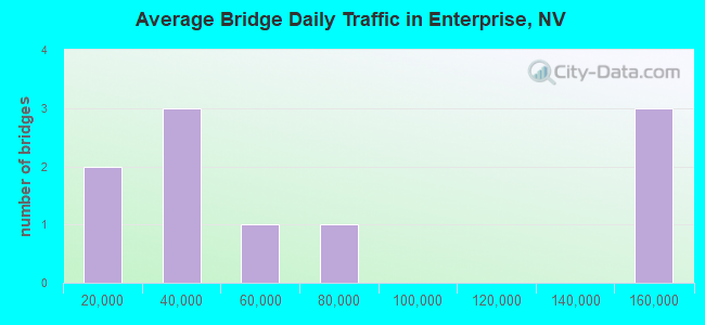
- 650,200Total average daily traffic
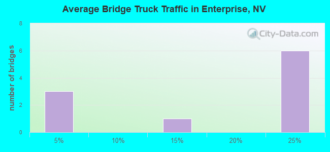
- 123,027Total average daily truck traffic
- National Bridge Inventory (NBI) Registered Bridges for Enterprise
- No street view available for this location
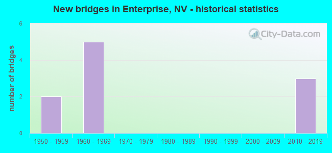
- New bridges - historical statistics
- 21950-1959
- 51960-1969
- 32010-2019

- Bridge Condition - Superstructure
- 33.3%Very good
- 66.7%Good
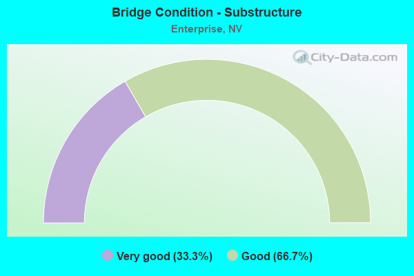
- Bridge Condition - Substructure
- 33.3%Very good
- 66.7%Good
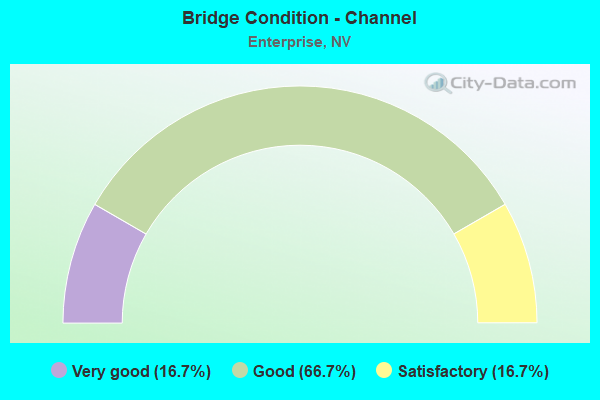
- Bridge Condition - Channel
- 16.7%Very good
- 66.7%Good
- 16.7%Satisfactory
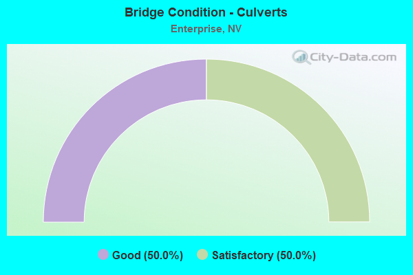
- Bridge Condition - Culverts
- 50.0%Good
- 50.0%Satisfactory
Find on map >> Show street view
Structure Number: B 673, Location: NEAR SLOAN (Lat: 35.965164, Lng: -115.174261), Route carried "on" structure: State highway 146, Year Built: 1961, Status: Open, Structure Length: 1.80m (5.91ft), Average Daily Traffic: 38,000 (year 2017), Truck Traffic: 10%, Average Future Daily Traffic: 78,588 (year 2040), Design Load: HS 20+Mod, Features Intersected: SLOAN WASH
Minimum Vertical Clearance: 30+ m (98+ ft), Kilometerpoint: 1.180, Lanes on structure: 12, Owner: State Highway Agency, Approaching Roadway Width: 53.3m (174.9ft), Skew: 23 degrees, Material/Design: Concrete, Design/Construction: Culvert, Number Of Spans In Main Unit: 4, Length of Maximum Span: 4.3m (14.1ft)
Condition: Channel: Good, Culverts: Satisfactory, Operating Rating: 72.5 metric tons, Method Used To Determine Operating Rating: Load Factor (LF), Inventory Rating: 43.4 metric tons, Method Used To Determine Inventory Rating: Load Factor (LF), Structural Evaluation: Equal to present minimum criteria, Waterway Adequacy: Equal to present desirable criteria, Approach Roadway Alignment: Equal to present desirable criteria, Designated Inspection Frequency: Every 48 months, Inspection Date: December 2020
Find on map >> Show street view
Structure Number: B 723, Location: NORTH OF SLOAN (Lat: 35.950214, Lng: -115.182275), Route carried "on" structure: Interstate 15, Year Built: 1961, Year Reconstructed: 1980, Status: Open, Structure Length: 1.83m (6.00ft), Average Daily Traffic: 59,000 (year 2017), Truck Traffic: 23%, Average Future Daily Traffic: 122,019 (year 2040), Design Load: HS 20+Mod, Features Intersected: SLOAN WASH
Minimum Vertical Clearance: 30+ m (98+ ft), Kilometerpoint: 43.372, Lanes on structure: 6, Base Highway Network: Yes, Owner: State Highway Agency, Approaching Roadway Width: 36.6m (120.1ft), Skew: 13 degrees, Material/Design: Concrete, Design/Construction: Culvert, Number Of Spans In Main Unit: 4, Length of Maximum Span: 4.3m (14.1ft)
Condition: Channel: Satisfactory, Culverts: Satisfactory, Operating Rating: 44.5 metric tons, Method Used To Determine Operating Rating: Load Factor (LF), Inventory Rating: 26.6 metric tons, Method Used To Determine Inventory Rating: Load Factor (LF), Structural Evaluation: Equal to present minimum criteria, Waterway Adequacy: Equal to present desirable criteria, Approach Roadway Alignment: Equal to present desirable criteria, Length Of Structure Improvement: 2.55m (8.37ft), Designated Inspection Frequency: Every 24 months, Inspection Date: October 2020, Bridge Improvement Cost: $457,000, Roadway Improvement Cost: $46,000, Total Project Cost: $686,000
Find on map >> Show street view
Structure Number: B 727, Location: SOUTH OF LAS VEGAS (Lat: 36.018828, Lng: -115.180369), Route carried "on" structure: Interstate 15, Year Built: 1961, Year Reconstructed: 1980, Status: Open, Structure Length: 0.82m (2.69ft), Average Daily Traffic: 140,000 (year 2017), Truck Traffic: 22%, Average Future Daily Traffic: 289,536 (year 2040), Design Load: HS 20+Mod, Features Intersected: DRY WASH
Minimum Vertical Clearance: 30+ m (98+ ft), Kilometerpoint: 51.116, Lanes on structure: 11, Base Highway Network: Yes, Owner: State Highway Agency, Approaching Roadway Width: 36.6m (120.1ft), Skew: 20 degrees, Material/Design: Concrete, Design/Construction: Culvert, Number Of Spans In Main Unit: 2, Length of Maximum Span: 3.7m (12.1ft)
Condition: Channel: Good, Culverts: Good, Operating Rating: 56.8 metric tons, Method Used To Determine Operating Rating: Load Factor (LF), Inventory Rating: 33.9 metric tons, Method Used To Determine Inventory Rating: Load Factor (LF), Structural Evaluation: Better than present minimum criteria, Waterway Adequacy: Equal to present desirable criteria, Approach Roadway Alignment: Equal to present desirable criteria, Length Of Structure Improvement: 1.48m (4.86ft), Designated Inspection Frequency: Every 48 months, Inspection Date: December 2020, Bridge Improvement Cost: $266,000, Roadway Improvement Cost: $27,000, Total Project Cost: $398,000
Find on map >> Show street view
Structure Number: B 728, Location: SOUTH OF LAS VEGAS (Lat: 36.025008, Lng: -115.180703), Route carried "on" structure: Interstate 15, Year Built: 1961, Year Reconstructed: 1980, Status: Open, Structure Length: 1.19m (3.90ft), Average Daily Traffic: 140,000 (year 2017), Truck Traffic: 22%, Average Future Daily Traffic: 150,000 (year 2040), Design Load: HS 20+Mod, Features Intersected: DRY WASH
Minimum Vertical Clearance: 30+ m (98+ ft), Kilometerpoint: 51.802, Lanes on structure: 10, Base Highway Network: Yes, Owner: State Highway Agency, Approaching Roadway Width: 51.8m (169.9ft), Skew: 20 degrees, Material/Design: Concrete, Design/Construction: Culvert, Number Of Spans In Main Unit: 3, Length of Maximum Span: 3.7m (12.1ft)
Condition: Channel: Good, Culverts: Good, Operating Rating: 47.3 metric tons, Method Used To Determine Operating Rating: Load Factor (LF), Inventory Rating: 28.4 metric tons, Method Used To Determine Inventory Rating: Load Factor (LF), Structural Evaluation: Better than present minimum criteria, Waterway Adequacy: Equal to present desirable criteria, Approach Roadway Alignment: Equal to present desirable criteria, Designated Inspection Frequency: Every 24 months, Inspection Date: December 2020
Find on map >> Show street view
Structure Number: B 729, Location: SOUTH OF LAS VEGAS (Lat: 36.041067, Lng: -115.180586), Route carried "on" structure: Interstate 15, Year Built: 1961, Year Reconstructed: 1980, Status: Open, Structure Length: 1.58m (5.18ft), Average Daily Traffic: 140,000 (year 2017), Truck Traffic: 22%, Average Future Daily Traffic: 289,536 (year 2040), Design Load: HS 20+Mod, Features Intersected: DRY WASH
Minimum Vertical Clearance: 30+ m (98+ ft), Kilometerpoint: 53.573, Lanes on structure: 13, Base Highway Network: Yes, Owner: State Highway Agency, Approaching Roadway Width: 21.9m (71.9ft), Skew: 30 degrees, Material/Design: Concrete, Design/Construction: Culvert, Number Of Spans In Main Unit: 4, Length of Maximum Span: 3.7m (12.1ft)
Condition: Channel: Good, Culverts: Satisfactory, Operating Rating: 48.6 metric tons, Method Used To Determine Operating Rating: Load Factor (LF), Inventory Rating: 29.4 metric tons, Method Used To Determine Inventory Rating: Load Factor (LF), Structural Evaluation: Equal to present minimum criteria, Waterway Adequacy: Equal to present desirable criteria, Approach Roadway Alignment: Equal to present desirable criteria, Length Of Structure Improvement: 2.26m (7.41ft), Designated Inspection Frequency: Every 24 months, Inspection Date: January 2021, Bridge Improvement Cost: $407,000, Roadway Improvement Cost: $41,000, Total Project Cost: $610,000
Find on map >> Show street view
Structure Number: B2986, Location: SOUTHWEST L.V (Lat: 36.012322, Lng: -115.243508), Route carried "on" structure: County highway , Year Built: 2010, Status: Open, Structure Length: 2.07m (6.79ft), Average Daily Traffic: 18,000 (year 2017), Truck Traffic: 4%, Average Future Daily Traffic: 37,226 (year 2040), Design Load: HS 20, Features Intersected: CHANNEL, Facility Carried by Structure: S. RAINBOW BLVD
Minimum Vertical Clearance: 30+ m (98+ ft), Kilometerpoint: 0.000, Lanes on structure: 2, Owner: County Highway Agency, Approaching Roadway Width: 8.2m (26.9ft), Skew: 2 degrees, Material/Design: Concrete, Design/Construction: Culvert, Number Of Spans In Main Unit: 5, Length of Maximum Span: 3.4m (11.2ft)
Condition: Channel: Very good, Culverts: Good, Operating Rating: 61.0 metric tons, Method Used To Determine Operating Rating: Load Factor (LF), Inventory Rating: 36.6 metric tons, Method Used To Determine Inventory Rating: Load Factor (LF), Structural Evaluation: Better than present minimum criteria, Waterway Adequacy: Equal to present desirable criteria, Approach Roadway Alignment: Equal to present desirable criteria, Designated Inspection Frequency: Every 48 months, Inspection Date: September 2021
Find on map >> Show street view
Structure Number: H296, Location: SOUTH LAS VEGAS (Lat: 36.063778, Lng: -115.181161), Route carried "on" structure: Ramp State lands road 215, Year Built: 2011, Status: Open, Structure Length: 8.67m (28.44ft), Average Daily Traffic: 8,900 (year 2017), Truck Traffic: 1%, Average Future Daily Traffic: 18,406 (year 2040), Design Load: HS 25 or greater, Features Intersected: I 215E/W
Minimum Vertical Clearance: 30+ m (98+ ft), Kilometerpoint: 0.000, Lanes on structure: 1, Lanes under structure: 8, Base Highway Network: Yes, Owner: State Highway Agency, Approaching Roadway Width: 8.5m (27.9ft), Skew: 1 degrees, Material/Design: Prestressed concrete continuous, Design/Construction: Box Beam or Girders - Single/Spread, Number Of Spans In Main Unit: 2, Length of Maximum Span: 43.4m (142.4ft), Curb-To-Curb Width: 8.5m (27.9ft), Out-to-Out Width: 9.4m (30.8ft)
Condition: Deck: Good, Superstructure: Very good, Substructure: Very good, Operating Rating: 47.6 metric tons, Method Used To Determine Operating Rating: Load and Resistance Factor (LRFR), Inventory Rating: 37.8 metric tons, Method Used To Determine Inventory Rating: Load and Resistance Factor (LRFR), Structural Evaluation: Equal to present desirable criteria, Deck Geometry: Superior to present desirable criteria, Underclear: High priority of corrective action, Approach Roadway Alignment: Equal to present desirable criteria, Designated Inspection Frequency: Every 24 months, Inspection Date: Febuary 2021, Deck Structure Type: Concrete Cast-file-Place, Wearing Surface/Protective System: Wearing Surface: Monolithic Concrete
Find on map >> Show street view
Structure Number: I 674N, Location: SLOAN (Lat: 35.930469, Lng: -115.192908), Route carried "on" structure: Interstate 15, Year Built: 1959, Status: Open, Structure Length: 3.75m (12.30ft), Average Daily Traffic: 23,150 (year 2017), Truck Traffic: 23%, Average Future Daily Traffic: 26,000 (year 2040), Design Load: HS 20+Mod, Features Intersected: SR 739/SLOAN RD
Minimum Vertical Clearance: 30+ m (98+ ft), Kilometerpoint: 41.095, Lanes on structure: 4, Lanes under structure: 2, Base Highway Network: Yes, Owner: State Highway Agency, Approaching Roadway Width: 21.3m (69.9ft), Material/Design: Concrete continuous, Design/Construction: Slab, Number Of Spans In Main Unit: 3, Length of Maximum Span: 14.3m (46.9ft), Curb-To-Curb Width: 21.3m (69.9ft), Out-to-Out Width: 22.3m (73.2ft)
Condition: Deck: Good, Superstructure: Good, Substructure: Good, Operating Rating: 78.4 metric tons, Method Used To Determine Operating Rating: Load Factor (LF), Inventory Rating: 47.0 metric tons, Method Used To Determine Inventory Rating: Load Factor (LF), Structural Evaluation: Better than present minimum criteria, Deck Geometry: Better than present minimum criteria, Underclear: Better than present minimum criteria, Approach Roadway Alignment: Equal to present desirable criteria, Designated Inspection Frequency: Every 48 months, Inspection Date: October 2020, Deck Structure Type: Concrete Cast-file-Place, Wearing Surface/Protective System: Wearing Surface: Bituminous
Find on map >> Show street view
Structure Number: I 674S, Location: SLOAN (Lat: 35.930619, Lng: -115.193178), Route carried "on" structure: Interstate 15, Year Built: 1959, Status: Open, Structure Length: 3.75m (12.30ft), Average Daily Traffic: 23,150 (year 2017), Truck Traffic: 23%, Average Future Daily Traffic: 26,000 (year 2040), Design Load: HS 20+Mod, Features Intersected: SR 739/SLOAN RD
Minimum Vertical Clearance: 30+ m (98+ ft), Kilometerpoint: 41.095, Lanes on structure: 3, Lanes under structure: 2, Base Highway Network: Yes, Owner: State Highway Agency, Approaching Roadway Width: 15.2m (49.9ft), Material/Design: Concrete continuous, Design/Construction: Slab, Number Of Spans In Main Unit: 3, Length of Maximum Span: 14.3m (46.9ft), Curb-To-Curb Width: 15.2m (49.9ft), Out-to-Out Width: 16.5m (54.1ft)
Condition: Deck: Good, Superstructure: Good, Substructure: Good, Operating Rating: 78.4 metric tons, Method Used To Determine Operating Rating: Load Factor (LF), Inventory Rating: 47.0 metric tons, Method Used To Determine Inventory Rating: Load Factor (LF), Structural Evaluation: Better than present minimum criteria, Deck Geometry: Meets minimum limits, Underclear: Better than present minimum criteria, Approach Roadway Alignment: Equal to present desirable criteria, Designated Inspection Frequency: Every 48 months, Inspection Date: October 2020, Deck Structure Type: Concrete Cast-file-Place, Wearing Surface/Protective System: Wearing Surface: Bituminous
Find on map >> Show street view
Structure Number: H296, Location: SOUTH LAS VEGAS (Lat: 36.063778, Lng: -115.181161), Route carried "under" structure: Interstate 215, Year Built: 2011, Structure Length: 0. m, Average Daily Traffic: 60,000 (year 2009), Truck Traffic: 3%, Features Intersected: I 215E/W
Minimum Vertical Clearance: 5.79m (19.00ft), Kilometerpoint: 0.000, Lanes on structure: 1, Lanes under structure: 8, Material/Design: Prestressed concrete continuous, Design/Construction: Box Beam or Girders - Single/Spread, Length of Maximum Span: 43.4m (142.4ft)