Bridge Statistics for Epping, New Hampshire (NH)
Condition, Traffic, Stress, Structural Evaluation, Project Costs
- National Bridge Inventory (NBI) Statistics
- 17Number of bridges
- 121ft / 37.1mTotal length
- $40,846,000Total costs
- 226,919Total average daily traffic
- 16,359Total average daily truck traffic
- National Bridge Inventory (NBI) Registered Bridges for Epping
- No street view available for this location
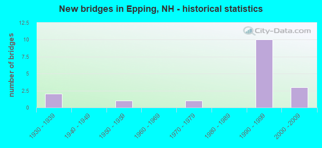
- New bridges - historical statistics
- 21930-1939
- 11950-1959
- 11970-1979
- 101990-1999
- 32000-2009


- Bridge Condition - Deck
- 54.5%Very good
- 27.3%Good
- 18.2%Fair

- Bridge Condition - Superstructure
- 27.3%Very good
- 54.5%Good
- 9.1%Satisfactory
- 9.1%Fair

- Bridge Condition - Substructure
- 63.6%Very good
- 9.1%Good
- 9.1%Satisfactory
- 18.2%Fair

- Bridge Condition - Channel
- 33.3%Excellent
- 11.1%Very good
- 44.4%Good
- 11.1%Satisfactory

- Bridge Condition - Culverts
- 50.0%Very good
- 50.0%Good
Find on map >> Show street view
Structure Number: 78005100053, Location: .65 MI. SE RAYMOND TL (Lat: 43.039281, Lng: -71.130164), Route carried "on" structure: Alternate State highway 27, Year Built: 1935, Status: Open, Structure Length: 1.38m (4.53ft), Average Daily Traffic: 4,369 (year 2020), Truck Traffic: 10%, Average Future Daily Traffic: 6,466 (year 2042), Design Load: H 15, Features Intersected: LAMPREY RIVER
Minimum Vertical Clearance: 30+ m (98+ ft), Kilometerpoint: 28.209, Lanes on structure: 2, Owner: State Highway Agency, Approaching Roadway Width: 9.1m (29.9ft), Skew: 2 degrees, Material/Design: Concrete, Design/Construction: Frame, Number Of Spans In Main Unit: 1, Length of Maximum Span: 11.8m (38.7ft), Curb or Sidewalk Widths: Left: 0.2m (0.7ft), Right: 0.2m (0.7ft), Curb-To-Curb Width: 9.2m (30.2ft), Out-to-Out Width: 10.5m (34.4ft)
Condition: Deck: Good, Superstructure: Good, Substructure: Fair, Channel: Good, Operating Rating: 35.7 metric tons, Method Used To Determine Operating Rating: Load Factor (LF), Inventory Rating: 21.4 metric tons, Method Used To Determine Inventory Rating: Load Factor (LF), Structural Evaluation: Somewhat better than minimum adequacy, Deck Geometry: Meets minimum limits, Waterway Adequacy: Equal to present desirable criteria, Approach Roadway Alignment: Equal to present desirable criteria, Length Of Structure Improvement: 1.38m (4.53ft), Designated Inspection Frequency: Every 24 months, Underwater Inspection Frequency: Every 60 months, Inspection Date: April 2021, Underwater Inspection Date: July 2017, Bridge Improvement Cost: $2,718,000, Roadway Improvement Cost: $200,000, Total Project Cost: $3,142,000 ( Estimate for 2022), Deck Structure Type: Concrete Cast-file-Place, Wearing Surface/Protective System: Wearing Surface: Bituminous
Find on map >> Show street view
Structure Number: 78005900054, Location: TOWN RD (Lat: 43.039756, Lng: -71.121894), Route carried "on" structure: Other road , Year Built: 1952, Status: Open, Structure Length: 1.25m (4.10ft), Average Daily Traffic: 525 (year 2020), Truck Traffic: 4%, Average Future Daily Traffic: 777 (year 2042), Design Load: H 15, Features Intersected: LAMPREY RIVER, Facility Carried by Structure: BLAKE ROAD
Minimum Vertical Clearance: 30+ m (98+ ft), Kilometerpoint: 0.103, Lanes on structure: 2, Owner: City or Municipal Highway Agency, Approaching Roadway Width: 5.5m (18.0ft), Material/Design: Concrete, Design/Construction: Tee Beam, Number Of Spans In Main Unit: 1, Length of Maximum Span: 10.4m (34.1ft), Curb or Sidewalk Widths: Left: 0.3m (1.0ft), Right: 0.3m (1.0ft), Curb-To-Curb Width: 5.5m (18.0ft), Out-to-Out Width: 6.9m (22.6ft)
Condition: Deck: Fair, Superstructure: Satisfactory, Substructure: Fair, Channel: Good, Operating Rating: 30.0 metric tons, Method Used To Determine Operating Rating: Allowable Stress (AS), Inventory Rating: 20.8 metric tons, Method Used To Determine Inventory Rating: Allowable Stress (AS), Structural Evaluation: Somewhat better than minimum adequacy, Deck Geometry: High priority of replacement, Waterway Adequacy: Equal to present desirable criteria, Approach Roadway Alignment: Equal to present minimum criteria, Length Of Structure Improvement: 1.25m (4.10ft), Designated Inspection Frequency: Every 24 months, Inspection Date: October 2020, Bridge Improvement Cost: $2,718,000, Roadway Improvement Cost: $200,000, Total Project Cost: $3,142,000 ( Estimate for 2022), Deck Structure Type: Concrete Cast-file-Place, Wearing Surface/Protective System: Wearing Surface: Bituminous
Find on map >> Show street view
Structure Number: 78006000038, Location: Junction Beede Rd &NH101 (Lat: 43.026869, Lng: -71.116917), Route carried "on" structure: Other road , Year Built: 1998, Status: Open, Structure Length: 6.19m (20.31ft), Average Daily Traffic: 455 (year 2020), Truck Traffic: 10%, Average Future Daily Traffic: 673 (year 2042), Design Load: HS 25 or greater, Features Intersected: NH101, Facility Carried by Structure: BEEDE ROAD
Minimum Vertical Clearance: 30+ m (98+ ft), Kilometerpoint: 0.657, Lanes on structure: 2, Lanes under structure: 4, Owner: State Highway Agency, Approaching Roadway Width: 13.4m (44.0ft), Skew: 3 degrees, Material/Design: Steel continuous, Design/Construction: Stringer/Multi-beam, Number Of Spans In Main Unit: 2, Length of Maximum Span: 30.2m (99.1ft), Curb or Sidewalk Widths: Left: 1.5m (4.9ft), Right: 0.2m (0.7ft), Curb-To-Curb Width: 13.3m (43.6ft), Out-to-Out Width: 15.7m (51.5ft)
Condition: Deck: Good, Superstructure: Good, Substructure: Very good, Operating Rating: 74.7 metric tons, Method Used To Determine Operating Rating: Load Factor (LF), Inventory Rating: 40.8 metric tons, Method Used To Determine Inventory Rating: Load Factor (LF), Structural Evaluation: Better than present minimum criteria, Deck Geometry: Superior to present desirable criteria, Underclear: Somewhat better than minimum adequacy, Approach Roadway Alignment: Equal to present desirable criteria, Length Of Structure Improvement: 6.19m (20.31ft), Designated Inspection Frequency: Every 24 months, Inspection Date: April 2021, Bridge Improvement Cost: $2,718,000, Roadway Improvement Cost: $200,000, Total Project Cost: $3,142,000 ( Estimate for 2022), Deck Structure Type: Concrete Cast-file-Place, Wearing Surface/Protective System: Wearing Surface: Integral Concrete, Deck Protection: Epoxy Coated Reinforcing
Find on map >> Show street view
Structure Number: 78009700033, Location: 1.1 MI WEST JCT NH101/125 (Lat: 43.027194, Lng: -71.085944), Route carried "on" structure: Other road , Year Built: 1995, Status: Open, Structure Length: 5.18m (16.99ft), Average Daily Traffic: 455 (year 2020), Truck Traffic: 4%, Average Future Daily Traffic: 673 (year 2042), Design Load: HS 25 or greater, Features Intersected: NH101, Facility Carried by Structure: MARTIN ROAD
Minimum Vertical Clearance: 30+ m (98+ ft), Kilometerpoint: 0.711, Lanes on structure: 2, Lanes under structure: 4, Owner: State Highway Agency, Approaching Roadway Width: 10.1m (33.1ft), Skew: 1 degrees, Material/Design: Steel continuous, Design/Construction: Stringer/Multi-beam, Number Of Spans In Main Unit: 2, Length of Maximum Span: 25.3m (83.0ft), Curb or Sidewalk Widths: Left: 0.2m (0.7ft), Right: 0.2m (0.7ft), Curb-To-Curb Width: 10.4m (34.1ft), Out-to-Out Width: 11.4m (37.4ft)
Condition: Deck: Very good, Superstructure: Good, Substructure: Very good, Operating Rating: 68.2 metric tons, Method Used To Determine Operating Rating: Allowable Stress (AS), Inventory Rating: 42.0 metric tons, Method Used To Determine Inventory Rating: Allowable Stress (AS), Structural Evaluation: Better than present minimum criteria, Deck Geometry: Equal to present minimum criteria, Underclear: Equal to present minimum criteria, Approach Roadway Alignment: Equal to present desirable criteria, Length Of Structure Improvement: 5.18m (16.99ft), Designated Inspection Frequency: Every 24 months, Inspection Date: April 2021, Bridge Improvement Cost: $2,718,000, Roadway Improvement Cost: $200,000, Total Project Cost: $3,142,000 ( Estimate for 2022), Deck Structure Type: Concrete Cast-file-Place, Wearing Surface/Protective System: Wearing Surface: Bituminous, Membrane: Preformed Fabric, Deck Protection: Epoxy Coated Reinforcing
Find on map >> Show street view
Structure Number: 78010900035, Location: 1.1MI E NH101/NH125 JCT (Lat: 43.024500, Lng: -71.062833), Route carried "on" structure: State highway 101, Year Built: 1997, Status: Open, Structure Length: 1.62m (5.31ft), Average Daily Traffic: 19,614 (year 2020), Truck Traffic: 7%, Average Future Daily Traffic: 29,028 (year 2042), Design Load: HS 25 or greater, Features Intersected: PISCASSIC RIVER
Minimum Vertical Clearance: 30+ m (98+ ft), Kilometerpoint: 52.886, Lanes on structure: 2, Base Highway Network: Yes, Owner: State Highway Agency, Approaching Roadway Width: 14.3m (46.9ft), Skew: 1 degrees, Material/Design: Prestressed concrete, Design/Construction: Stringer/Multi-beam, Number Of Spans In Main Unit: 1, Length of Maximum Span: 14.3m (46.9ft), Curb or Sidewalk Widths: Left: 0.0m, Right: 0.1m (0.3ft), Curb-To-Curb Width: 14.3m (46.9ft), Out-to-Out Width: 15.2m (49.9ft)
Condition: Deck: Very good, Superstructure: Very good, Substructure: Very good, Channel: Very good, Operating Rating: 87.0 metric tons, Method Used To Determine Operating Rating: Load Factor (LF), Inventory Rating: 52.3 metric tons, Method Used To Determine Inventory Rating: Load Factor (LF), Structural Evaluation: Equal to present desirable criteria, Deck Geometry: Superior to present desirable criteria, Waterway Adequacy: Equal to present desirable criteria, Approach Roadway Alignment: Equal to present desirable criteria, Length Of Structure Improvement: 1.62m (5.31ft), Designated Inspection Frequency: Every 24 months, Inspection Date: April 2021, Bridge Improvement Cost: $2,718,000, Roadway Improvement Cost: $200,000, Total Project Cost: $3,142,000 ( Estimate for 2022), Deck Structure Type: Concrete Cast-file-Place, Wearing Surface/Protective System: Wearing Surface: Bituminous, Membrane: Preformed Fabric, Deck Protection: Epoxy Coated Reinforcing
Find on map >> Show street view
Structure Number: 78010900037, Location: .4 MI N BRENTWOOD TL (Lat: 43.026289, Lng: -71.073811), Route carried "on" structure: State highway 101, Year Built: 1997, Status: Open, Structure Length: 3.41m (11.19ft), Average Daily Traffic: 22,433 (year 2020), Truck Traffic: 7%, Average Future Daily Traffic: 33,200 (year 2042), Design Load: HS 25 or greater, Features Intersected: NH125
Minimum Vertical Clearance: 30+ m (98+ ft), Kilometerpoint: 126.494, Lanes on structure: 2, Lanes under structure: 5, Base Highway Network: Yes, Owner: State Highway Agency, Approaching Roadway Width: 12.5m (41.0ft), Skew: 2 degrees, Material/Design: Steel, Design/Construction: Stringer/Multi-beam, Number Of Spans In Main Unit: 1, Length of Maximum Span: 31.7m (104.0ft), Curb or Sidewalk Widths: Left: 0.2m (0.7ft), Right: 0.2m (0.7ft), Curb-To-Curb Width: 12.4m (40.7ft), Out-to-Out Width: 13.6m (44.6ft)
Condition: Deck: Very good, Superstructure: Good, Substructure: Good, Operating Rating: 82.6 metric tons, Method Used To Determine Operating Rating: Load Factor (LF), Inventory Rating: 49.6 metric tons, Method Used To Determine Inventory Rating: Load Factor (LF), Structural Evaluation: Better than present minimum criteria, Deck Geometry: Better than present minimum criteria, Underclear: Somewhat better than minimum adequacy, Approach Roadway Alignment: Equal to present desirable criteria, Length Of Structure Improvement: 3.41m (11.19ft), Designated Inspection Frequency: Every 24 months, Inspection Date: April 2021, Bridge Improvement Cost: $2,718,000, Roadway Improvement Cost: $200,000, Total Project Cost: $3,142,000 ( Estimate for 2022), Deck Structure Type: Concrete Cast-file-Place, Wearing Surface/Protective System: Wearing Surface: Bituminous, Membrane: Preformed Fabric, Deck Protection: Epoxy Coated Reinforcing
Find on map >> Show street view
Structure Number: 78010900038, Location: .41 MI N BRENTWOOD TL (Lat: 43.026506, Lng: -71.073761), Route carried "on" structure: State highway 101, Year Built: 1996, Status: Open, Structure Length: 3.29m (10.79ft), Average Daily Traffic: 22,225 (year 2020), Truck Traffic: 8%, Average Future Daily Traffic: 32,893 (year 2042), Design Load: HS 25 or greater, Features Intersected: NH125
Minimum Vertical Clearance: 30+ m (98+ ft), Kilometerpoint: 53.804, Lanes on structure: 2, Lanes under structure: 5, Base Highway Network: Yes, Owner: State Highway Agency, Approaching Roadway Width: 12.5m (41.0ft), Skew: 2 degrees, Material/Design: Steel, Design/Construction: Stringer/Multi-beam, Number Of Spans In Main Unit: 1, Length of Maximum Span: 31.7m (104.0ft), Curb or Sidewalk Widths: Left: 0.2m (0.7ft), Right: 0.2m (0.7ft), Curb-To-Curb Width: 12.6m (41.3ft), Out-to-Out Width: 13.6m (44.6ft)
Condition: Deck: Very good, Superstructure: Very good, Substructure: Very good, Operating Rating: 87.0 metric tons, Method Used To Determine Operating Rating: Load Factor (LF), Inventory Rating: 52.3 metric tons, Method Used To Determine Inventory Rating: Load Factor (LF), Structural Evaluation: Equal to present desirable criteria, Deck Geometry: Somewhat better than minimum adequacy, Underclear: Meets minimum limits, Approach Roadway Alignment: Equal to present desirable criteria, Length Of Structure Improvement: 3.29m (10.79ft), Designated Inspection Frequency: Every 24 months, Inspection Date: April 2021, Bridge Improvement Cost: $2,718,000, Roadway Improvement Cost: $200,000, Total Project Cost: $3,142,000 ( Estimate for 2022), Deck Structure Type: Concrete Cast-file-Place, Wearing Surface/Protective System: Wearing Surface: Bituminous, Membrane: Preformed Fabric, Deck Protection: Epoxy Coated Reinforcing
Find on map >> Show street view
Structure Number: 78010900055, Location: 0.7 MI. RTE 125 (Lat: 43.039875, Lng: -71.073233), Route carried "on" structure: Other road , Year Built: 1936, Status: Open, Structure Length: 1.74m (5.71ft), Average Daily Traffic: 3,660 (year 2020), Truck Traffic: 4%, Average Future Daily Traffic: 5,416 (year 2042), Design Load: H 10, Features Intersected: LAMPREY RIVER, Facility Carried by Structure: MAIN STREET
Minimum Vertical Clearance: 30+ m (98+ ft), Kilometerpoint: 0.164, Lanes on structure: 2, Owner: City or Municipal Highway Agency, Approaching Roadway Width: 6.1m (20.0ft), Material/Design: Concrete, Design/Construction: Frame, Number Of Spans In Main Unit: 1, Length of Maximum Span: 15.2m (49.9ft), Curb or Sidewalk Widths: Left: 0.2m (0.7ft), Right: 1.5m (4.9ft), Curb-To-Curb Width: 6.4m (21.0ft), Out-to-Out Width: 8.9m (29.2ft)
Condition: Deck: Fair, Superstructure: Fair, Substructure: Satisfactory, Channel: Good, Operating Rating: 25.4 metric tons, Method Used To Determine Operating Rating: Load Factor (LF), Inventory Rating: 10.9 metric tons, Method Used To Determine Inventory Rating: Load Factor (LF), Structural Evaluation: High priority of replacement, Deck Geometry: High priority of replacement, Waterway Adequacy: Equal to present desirable criteria, Approach Roadway Alignment: Equal to present desirable criteria, Length Of Structure Improvement: 1.74m (5.71ft), Designated Inspection Frequency: Every 24 months, Inspection Date: October 2020, Bridge Improvement Cost: $2,718,000, Roadway Improvement Cost: $200,000, Total Project Cost: $3,142,000 ( Estimate for 2022), Deck Structure Type: Concrete Cast-file-Place, Wearing Surface/Protective System: Wearing Surface: Bituminous
Find on map >> Show street view
Structure Number: 78011200055, Location: TOWN RD (Lat: 43.038161, Lng: -71.070856), Route carried "on" structure: Other road , Year Built: 2004, Status: Open, Structure Length: 3.57m (11.71ft), Average Daily Traffic: 1,090 (year 2020), Truck Traffic: 4%, Average Future Daily Traffic: 1,613 (year 2042), Design Load: HS 25 or greater, Features Intersected: LAMPREY RIVER, Facility Carried by Structure: MILL STREET
Minimum Vertical Clearance: 30+ m (98+ ft), Kilometerpoint: 0.045, Lanes on structure: 2, Owner: City or Municipal Highway Agency, Approaching Roadway Width: 7.3m (24.0ft), Material/Design: Prestressed concrete, Design/Construction: Box Beam or Girders - Multiple, Number Of Spans In Main Unit: 1, Length of Maximum Span: 34.4m (112.9ft), Curb-To-Curb Width: 7.3m (24.0ft), Out-to-Out Width: 8.5m (27.9ft)
Condition: Deck: Good, Superstructure: Good, Substructure: Very good, Channel: Excellent, Operating Rating: 43.1 metric tons, Method Used To Determine Operating Rating: Load Factor (LF), Inventory Rating: 36.9 metric tons, Method Used To Determine Inventory Rating: Load Factor (LF), Structural Evaluation: Better than present minimum criteria, Deck Geometry: Meets minimum limits, Waterway Adequacy: Equal to present desirable criteria, Approach Roadway Alignment: Equal to present minimum criteria, Length Of Structure Improvement: 3.57m (11.71ft), Designated Inspection Frequency: Every 24 months, Inspection Date: October 2020, Bridge Improvement Cost: $2,718,000, Roadway Improvement Cost: $200,000, Total Project Cost: $3,142,000 ( Estimate for 2022), Deck Structure Type: Concrete Precast Panels, Wearing Surface/Protective System: Wearing Surface: Bituminous, Membrane: Preformed Fabric, Deck Protection: Epoxy Coated Reinforcing
Find on map >> Show street view
Structure Number: 78011300051, Location: 0.7 MI FROM JCT RTE 101 (Lat: 43.036819, Lng: -71.068825), Route carried "on" structure: State highway 125, Year Built: 1991, Status: Open, Structure Length: 3.32m (10.89ft), Average Daily Traffic: 16,380 (year 2020), Truck Traffic: 7%, Average Future Daily Traffic: 24,242 (year 2042), Design Load: HS 25 or greater, Features Intersected: LAMPREY RIVER
Minimum Vertical Clearance: 30+ m (98+ ft), Kilometerpoint: 27.710, Lanes on structure: 3, Base Highway Network: Yes, Owner: State Highway Agency, Approaching Roadway Width: 19.5m (64.0ft), Skew: 20 degrees, Material/Design: Steel, Design/Construction: Stringer/Multi-beam, Number Of Spans In Main Unit: 1, Length of Maximum Span: 32.0m (105.0ft), Curb or Sidewalk Widths: Left: 0.2m (0.7ft), Right: 0.2m (0.7ft), Curb-To-Curb Width: 19.5m (64.0ft), Out-to-Out Width: 20.6m (67.6ft)
Condition: Deck: Very good, Superstructure: Good, Substructure: Very good, Channel: Good, Operating Rating: 74.8 metric tons, Method Used To Determine Operating Rating: Load Factor (LF), Inventory Rating: 44.7 metric tons, Method Used To Determine Inventory Rating: Load Factor (LF), Structural Evaluation: Better than present minimum criteria, Deck Geometry: Superior to present desirable criteria, Waterway Adequacy: Superior to present desirable criteria, Approach Roadway Alignment: Equal to present desirable criteria, Length Of Structure Improvement: 3.32m (10.89ft), Designated Inspection Frequency: Every 24 months, Inspection Date: April 2021, Bridge Improvement Cost: $2,718,000, Roadway Improvement Cost: $200,000, Total Project Cost: $3,142,000 ( Estimate for 2022), Deck Structure Type: Concrete Cast-file-Place, Wearing Surface/Protective System: Wearing Surface: Bituminous, Membrane: Preformed Fabric, Deck Protection: Epoxy Coated Reinforcing
Find on map >> Show street view
Structure Number: 78014600111, Location: 0.1 MI. S. JCT. 155 (Lat: 43.079322, Lng: -71.035422), Route carried "on" structure: State highway 125, Year Built: 1977, Status: Open, Structure Length: 1.28m (4.20ft), Average Daily Traffic: 14,575 (year 2020), Truck Traffic: 7%, Average Future Daily Traffic: 21,571 (year 2042), Design Load: HS 20+Mod, Features Intersected: NORTH RIVER
Minimum Vertical Clearance: 30+ m (98+ ft), Kilometerpoint: 33.215, Lanes on structure: 3, Base Highway Network: Yes, Owner: State Highway Agency, Approaching Roadway Width: 12.8m (42.0ft), Material/Design: Concrete continuous, Design/Construction: Culvert, Number Of Spans In Main Unit: 2, Length of Maximum Span: 6.1m (20.0ft)
Condition: Channel: Satisfactory, Culverts: Good, Operating Rating: 89.8 metric tons, Method Used To Determine Operating Rating: Load Factor (LF), Inventory Rating: 89.8 metric tons, Method Used To Determine Inventory Rating: Load Factor (LF), Structural Evaluation: Better than present minimum criteria, Waterway Adequacy: Equal to present desirable criteria, Approach Roadway Alignment: Equal to present desirable criteria, Length Of Structure Improvement: 1.28m (4.20ft), Designated Inspection Frequency: Every 24 months, Inspection Date: April 2021, Bridge Improvement Cost: $2,718,000, Roadway Improvement Cost: $200,000, Total Project Cost: $3,142,000 ( Estimate for 2022)
Find on map >> Show street view
Structure Number: 78015000069, Location: 1.25 MI SE JCT NH 125 (Lat: 43.049519, Lng: -71.032267), Route carried "on" structure: State highway 87, Year Built: 2004, Status: Open, Structure Length: 0.78m (2.56ft), Average Daily Traffic: 2,569 (year 2020), Truck Traffic: 4%, Average Future Daily Traffic: 3,802 (year 2042), Design Load: HS 25 or greater, Features Intersected: LAMPREY RIVER OVERFLOW
Minimum Vertical Clearance: 30+ m (98+ ft), Kilometerpoint: 1.918, Lanes on structure: 2, Owner: State Highway Agency, Approaching Roadway Width: 9.5m (31.2ft), Material/Design: Concrete, Design/Construction: Culvert, Number Of Spans In Main Unit: 1, Length of Maximum Span: 7.3m (24.0ft)
Condition: Channel: Excellent, Culverts: Very good, Operating Rating: 81.6 metric tons, Method Used To Determine Operating Rating: Load Factor (LF), Inventory Rating: 49.0 metric tons, Method Used To Determine Inventory Rating: Load Factor (LF), Structural Evaluation: Equal to present desirable criteria, Waterway Adequacy: Superior to present desirable criteria, Approach Roadway Alignment: Superior to present desirable criteria, Length Of Structure Improvement: 0.78m (2.56ft), Designated Inspection Frequency: Every 24 months, Inspection Date: April 2021, Bridge Improvement Cost: $2,718,000, Roadway Improvement Cost: $200,000, Total Project Cost: $3,142,000 ( Estimate for 2022)
Find on map >> Show street view
Structure Number: 78015100069, Location: 1.2 MI. SE JCT NH 125 (Lat: 43.049492, Lng: -71.032900), Route carried "on" structure: State highway 87, Year Built: 2004, Status: Open, Structure Length: 4.13m (13.55ft), Average Daily Traffic: 2,569 (year 2020), Truck Traffic: 4%, Average Future Daily Traffic: 3,802 (year 2042), Design Load: HS 25 or greater, Features Intersected: LAMPREY RIVER
Minimum Vertical Clearance: 30+ m (98+ ft), Kilometerpoint: 1.867, Lanes on structure: 2, Owner: State Highway Agency, Approaching Roadway Width: 9.7m (31.8ft), Skew: 4 degrees, Material/Design: Steel, Design/Construction: Stringer/Multi-beam, Number Of Spans In Main Unit: 1, Length of Maximum Span: 38.5m (126.3ft), Curb or Sidewalk Widths: Left: 0.1m (0.3ft), Right: 0.1m (0.3ft), Curb-To-Curb Width: 10.0m (32.8ft), Out-to-Out Width: 11.8m (38.7ft)
Condition: Deck: Very good, Superstructure: Very good, Substructure: Very good, Channel: Excellent, Operating Rating: 75.8 metric tons, Method Used To Determine Operating Rating: Load Factor (LF), Inventory Rating: 45.4 metric tons, Method Used To Determine Inventory Rating: Load Factor (LF), Structural Evaluation: Equal to present desirable criteria, Deck Geometry: Meets minimum limits, Waterway Adequacy: Better than present minimum criteria, Approach Roadway Alignment: Superior to present desirable criteria, Length Of Structure Improvement: 4.13m (13.55ft), Designated Inspection Frequency: Every 24 months, Inspection Date: April 2021, Bridge Improvement Cost: $2,718,000, Roadway Improvement Cost: $200,000, Total Project Cost: $3,142,000 ( Estimate for 2022), Deck Structure Type: Concrete Cast-file-Place, Wearing Surface/Protective System: Wearing Surface: Bituminous, Membrane: Other, Deck Protection: Epoxy Coated Reinforcing
Find on map >> Show street view
Structure Number: 78006000038, Location: Junction Beede Rd &NH101 (Lat: 43.026869, Lng: -71.116917), Route carried "under" structure: State highway 101, Year Built: 1998, Structure Length: 0. m, Average Daily Traffic: 44,000 (year 2015), Truck Traffic: 8%, Features Intersected: NH101, Facility Carried by Structure: BEEDE ROAD
Minimum Vertical Clearance: 5.12m (16.80ft), Kilometerpoint: 2.736, Lanes on structure: 2, Lanes under structure: 4, Material/Design: Steel continuous, Design/Construction: Stringer/Multi-beam, Length of Maximum Span: 30.2m (99.1ft)
Find on map >> Show street view
Structure Number: 78009700033, Location: 1.1 MI WEST JCT NH101/125 (Lat: 43.027194, Lng: -71.085944), Route carried "under" structure: State highway 101, Year Built: 1995, Structure Length: 0. m, Average Daily Traffic: 24,000 (year 2015), Truck Traffic: 7%, Features Intersected: NH101, Facility Carried by Structure: MARTIN ROAD
Minimum Vertical Clearance: 5.12m (16.80ft), Kilometerpoint: 5.198, Lanes on structure: 2, Lanes under structure: 4, Material/Design: Steel continuous, Design/Construction: Stringer/Multi-beam, Length of Maximum Span: 25.3m (83.0ft)
Find on map >> Show street view
Structure Number: 78010900037, Location: .4 MI N BRENTWOOD TL (Lat: 43.026289, Lng: -71.073811), Route carried "under" structure: State highway 125, Year Built: 1997, Structure Length: 0. m, Average Daily Traffic: 21,000 (year 2013), Truck Traffic: 7%, Features Intersected: NH125, Facility Carried by Structure: NH101 EB
Minimum Vertical Clearance: 15.00m (49.21ft), Kilometerpoint: 0.400, Lanes on structure: 2, Lanes under structure: 5, Material/Design: Steel, Design/Construction: Stringer/Multi-beam, Length of Maximum Span: 31.7m (104.0ft)
Find on map >> Show street view
Structure Number: 78010900038, Location: .41 MI N BRENTWOOD TL (Lat: 43.026506, Lng: -71.073761), Route carried "under" structure: State highway 125, Year Built: 1996, Structure Length: 0. m, Average Daily Traffic: 27,000 (year 2009), Truck Traffic: 7%, Features Intersected: NH125, Facility Carried by Structure: NH101 WB
Minimum Vertical Clearance: 5.18m (16.99ft), Kilometerpoint: 1.000, Lanes on structure: 2, Lanes under structure: 5, Material/Design: Steel, Design/Construction: Stringer/Multi-beam, Length of Maximum Span: 31.7m (104.0ft)