Bridge Statistics for Estill Springs, Tennessee (TN)
Condition, Traffic, Stress, Structural Evaluation, Project Costs
- National Bridge Inventory (NBI) Statistics
- 18Number of bridges
- 249ft / 76.3mTotal length
- $12,178,000Total costs
- 49,121Total average daily traffic
- 3,735Total average daily truck traffic
- National Bridge Inventory (NBI) Registered Bridges for Estill Springs
- No street view available for this location
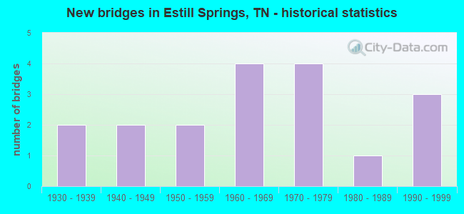
- New bridges - historical statistics
- 21930-1939
- 21940-1949
- 21950-1959
- 41960-1969
- 41970-1979
- 11980-1989
- 31990-1999


- Bridge Condition - Deck
- 12.5%Very good
- 50.0%Good
- 25.0%Fair
- 12.5%Poor

- Bridge Condition - Superstructure
- 12.5%Very good
- 50.0%Good
- 37.5%Fair

- Bridge Condition - Substructure
- 12.5%Very good
- 50.0%Good
- 37.5%Satisfactory

- Bridge Condition - Channel
- 11.8%Very good
- 52.9%Good
- 23.5%Satisfactory
- 11.8%Fair

- Bridge Condition - Culverts
- 66.7%Good
- 22.2%Satisfactory
- 11.1%Fair
Find on map >> Show street view
Structure Number: 26021100001, Location: WEST OF SR130 (Lat: 35.274333, Lng: -86.205233), Route carried "on" structure: County highway 2110, Year Built: 1972, Status: Open, Structure Length: 0.79m (2.59ft), Average Daily Traffic: 958 (year 2020), Truck Traffic: 3%, Average Future Daily Traffic: 1,533 (year 2041), Design Load: HS 20, Features Intersected: LITTLE HURRICANE CREEK
Minimum Vertical Clearance: 30+ m (98+ ft), Kilometerpoint: 1.400, Lanes on structure: 2, Owner: County Highway Agency, Approaching Roadway Width: 7.3m (24.0ft), Material/Design: Concrete continuous, Design/Construction: Culvert, Number Of Spans In Main Unit: 2, Length of Maximum Span: 3.7m (12.1ft)
Condition: Channel: Satisfactory, Culverts: Satisfactory, Operating Rating: 54.0 metric tons, Method Used To Determine Operating Rating: Field evaluation and documented engineering judgment, Inventory Rating: 32.4 metric tons, Method Used To Determine Inventory Rating: Field evaluation and documented engineering judgment, Structural Evaluation: Equal to present minimum criteria, Waterway Adequacy: Better than present minimum criteria, Approach Roadway Alignment: Equal to present minimum criteria, Designated Inspection Frequency: Every 24 months, Inspection Date: July 2021
Find on map >> Show street view
Structure Number: 26026180001, Location: EAST OF SR16 (Lat: 35.307233, Lng: -86.122467), Route carried "on" structure: County highway 1, Year Built: 1979, Status: Open, Structure Length: 1.19m (3.90ft), Average Daily Traffic: 890 (year 2022), Truck Traffic: 2%, Average Future Daily Traffic: 1,424 (year 2041), Design Load: HS 20, Features Intersected: SPRING CREEK
Minimum Vertical Clearance: 30+ m (98+ ft), Kilometerpoint: 2.721, Lanes on structure: 2, Owner: County Highway Agency, Approaching Roadway Width: 7.6m (24.9ft), Material/Design: Concrete continuous, Design/Construction: Culvert, Number Of Spans In Main Unit: 3, Length of Maximum Span: 3.7m (12.1ft), Curb-To-Curb Width: 13.7m (44.9ft), Out-to-Out Width: 22.6m (74.1ft)
Condition: Channel: Satisfactory, Culverts: Good, Operating Rating: 54.0 metric tons, Method Used To Determine Operating Rating: Field evaluation and documented engineering judgment, Inventory Rating: 32.4 metric tons, Method Used To Determine Inventory Rating: Field evaluation and documented engineering judgment, Structural Evaluation: Better than present minimum criteria, Deck Geometry: Superior to present desirable criteria, Waterway Adequacy: Better than present minimum criteria, Approach Roadway Alignment: Equal to present desirable criteria, Designated Inspection Frequency: Every 24 months, Inspection Date: September 2021
Find on map >> Show street view
Structure Number: 260A0230001, Location: EAST OF SR16 (Lat: 35.275617, Lng: -86.109483), Route carried "on" structure: County highway 23, Year Built: 1972, Status: Open, Structure Length: 7.96m (26.12ft), Average Daily Traffic: 880 (year 2022), Truck Traffic: 2%, Average Future Daily Traffic: 1,408 (year 2041), Design Load: H 15, Features Intersected: ELK RIVER
Minimum Vertical Clearance: 30+ m (98+ ft), Kilometerpoint: 2.054, Lanes on structure: 2, Owner: County Highway Agency, Approaching Roadway Width: 7.3m (24.0ft), Material/Design: Prestressed concrete, Design/Construction: Box Beam or Girders - Multiple, Number Of Spans In Main Unit: 6, Length of Maximum Span: 15.2m (49.9ft), Curb-To-Curb Width: 6.9m (22.6ft), Out-to-Out Width: 7.6m (24.9ft)
Condition: Deck: Fair, Superstructure: Fair, Substructure: Satisfactory, Channel: Good, Operating Rating: 36.0 metric tons, Method Used To Determine Operating Rating: Field evaluation and documented engineering judgment, Inventory Rating: 24.3 metric tons, Method Used To Determine Inventory Rating: Field evaluation and documented engineering judgment, Structural Evaluation: Somewhat better than minimum adequacy, Deck Geometry: Meets minimum limits, Waterway Adequacy: Better than present minimum criteria, Approach Roadway Alignment: Equal to present minimum criteria, Length Of Structure Improvement: 7.96m (26.12ft), Designated Inspection Frequency: Every 24 months, Inspection Date: September 2021, Bridge Improvement Cost: $438,000, Roadway Improvement Cost: $44,000, Total Project Cost: $658,000 ( Estimate for 2021), Deck Structure Type: Other, Wearing Surface/Protective System: Wearing Surface: Bituminous
Find on map >> Show street view
Structure Number: 260A1230001, Location: EAST OF SR130 (Lat: 35.287567, Lng: -86.187767), Route carried "on" structure: County highway 123, Year Built: 1994, Status: Open, Structure Length: 3.20m (10.50ft), Average Daily Traffic: 810 (year 2022), Truck Traffic: 2%, Average Future Daily Traffic: 1,296 (year 2039), Design Load: HS 20, Features Intersected: ROCK CREEK
Minimum Vertical Clearance: 30+ m (98+ ft), Kilometerpoint: 1.255, Lanes on structure: 2, Owner: County Highway Agency, Approaching Roadway Width: 7.3m (24.0ft), Material/Design: Prestressed concrete, Design/Construction: Stringer/Multi-beam, Number Of Spans In Main Unit: 1, Length of Maximum Span: 32.0m (105.0ft), Curb-To-Curb Width: 7.3m (24.0ft), Out-to-Out Width: 7.9m (25.9ft)
Condition: Deck: Very good, Superstructure: Very good, Substructure: Very good, Channel: Very good, Operating Rating: 44.1 metric tons, Method Used To Determine Operating Rating: Assigned rating based on Load Factor Design (LFD) reported in metric tons, Inventory Rating: 32.4 metric tons, Method Used To Determine Inventory Rating: Assigned rating based on Load Factor Design (LFD) reported in metric tons, Structural Evaluation: Equal to present desirable criteria, Deck Geometry: Meets minimum limits, Waterway Adequacy: Equal to present desirable criteria, Approach Roadway Alignment: Equal to present minimum criteria, Designated Inspection Frequency: Every 24 months, Inspection Date: August 2021, Deck Structure Type: Concrete Precast Panels, Wearing Surface/Protective System: Wearing Surface: Monolithic Concrete, Deck Protection: Epoxy Coated Reinforcing
Find on map >> Show street view
Structure Number: 260A1250001, Location: EAST OF SR130 (Lat: 35.274550, Lng: -86.172683), Route carried "on" structure: County highway 125, Year Built: 1985, Status: Open, Structure Length: 4.51m (14.80ft), Average Daily Traffic: 810 (year 2022), Truck Traffic: 2%, Average Future Daily Traffic: 1,296 (year 2041), Design Load: HS 20, Features Intersected: ROCK CREEK
Minimum Vertical Clearance: 30+ m (98+ ft), Kilometerpoint: 0.721, Lanes on structure: 2, Owner: County Highway Agency, Approaching Roadway Width: 9.1m (29.9ft), Skew: 3 degrees, Material/Design: Prestressed concrete continuous, Design/Construction: Stringer/Multi-beam, Number Of Spans In Main Unit: 3, Length of Maximum Span: 14.9m (48.9ft), Curb-To-Curb Width: 7.3m (24.0ft), Out-to-Out Width: 8.0m (26.2ft)
Condition: Deck: Good, Superstructure: Good, Substructure: Good, Channel: Very good, Operating Rating: 44.1 metric tons, Method Used To Determine Operating Rating: Assigned rating based on Load Factor Design (LFD) reported in metric tons, Inventory Rating: 32.4 metric tons, Method Used To Determine Inventory Rating: Assigned rating based on Load Factor Design (LFD) reported in metric tons, Structural Evaluation: Better than present minimum criteria, Deck Geometry: Meets minimum limits, Waterway Adequacy: Better than present minimum criteria, Approach Roadway Alignment: Equal to present minimum criteria, Length Of Structure Improvement: 4.51m (14.80ft), Designated Inspection Frequency: Every 24 months, Inspection Date: August 2021, Bridge Improvement Cost: $139,000, Roadway Improvement Cost: $14,000, Total Project Cost: $209,000 ( Estimate for 2021), Deck Structure Type: Concrete Precast Panels, Wearing Surface/Protective System: Wearing Surface: Monolithic Concrete
Find on map >> Show street view
Structure Number: 260A2010001, Location: EAST OF SR16 (Lat: 35.267733, Lng: -86.135833), Route carried "on" structure: City street 1088, Year Built: 1970, Status: Open, Structure Length: 0.76m (2.49ft), Average Daily Traffic: 1,725 (year 2020), Truck Traffic: 3%, Average Future Daily Traffic: 2,760 (year 2041), Design Load: HS 20, Features Intersected: TAYLOR CREEK
Minimum Vertical Clearance: 30+ m (98+ ft), Kilometerpoint: 5.890, Lanes on structure: 2, Owner: City or Municipal Highway Agency, Approaching Roadway Width: 8.8m (28.9ft), Material/Design: Concrete continuous, Design/Construction: Culvert, Number Of Spans In Main Unit: 2, Length of Maximum Span: 3.0m (9.8ft)
Condition: Channel: Good, Culverts: Good, Operating Rating: 54.0 metric tons, Method Used To Determine Operating Rating: Field evaluation and documented engineering judgment, Inventory Rating: 32.4 metric tons, Method Used To Determine Inventory Rating: Field evaluation and documented engineering judgment, Structural Evaluation: Better than present minimum criteria, Waterway Adequacy: Equal to present desirable criteria, Approach Roadway Alignment: Equal to present minimum criteria, Designated Inspection Frequency: Every 24 months, Inspection Date: July 2021
Find on map >> Show street view
Structure Number: 260A2260001, Location: WEST OF SR16 (Lat: 35.290533, Lng: -86.163067), Route carried "on" structure: County highway 226, Year Built: 1996, Status: Open, Structure Length: 1.04m (3.41ft), Average Daily Traffic: 490 (year 2022), Truck Traffic: 2%, Average Future Daily Traffic: 784 (year 2039), Design Load: HS 20, Features Intersected: DRY CREEK
Minimum Vertical Clearance: 30+ m (98+ ft), Kilometerpoint: 1.485, Lanes on structure: 2, Owner: County Highway Agency, Approaching Roadway Width: 7.0m (23.0ft), Skew: 1 degrees, Material/Design: Concrete continuous, Design/Construction: Culvert, Number Of Spans In Main Unit: 2, Length of Maximum Span: 4.9m (16.1ft)
Condition: Channel: Good, Culverts: Good, Operating Rating: 89.1 metric tons, Method Used To Determine Operating Rating: Load Factor (LF), Inventory Rating: 32.4 metric tons, Method Used To Determine Inventory Rating: Load Factor (LF), Structural Evaluation: Better than present minimum criteria, Waterway Adequacy: Better than present minimum criteria, Approach Roadway Alignment: Equal to present minimum criteria, Designated Inspection Frequency: Every 24 months, Inspection Date: August 2021
Find on map >> Show street view
Structure Number: 260A2640001, Location: EAST OF SR16 (Lat: 35.262933, Lng: -86.102417), Route carried "on" structure: County highway 264, Year Built: 1950, Status: Posted for load, Structure Length: 0.67m (2.20ft), Average Daily Traffic: 230 (year 2022), Truck Traffic: 2%, Average Future Daily Traffic: 368 (year 2042), Design Load: HS 20, Features Intersected: BRANCH
Minimum Vertical Clearance: 30+ m (98+ ft), Kilometerpoint: 1.722, Lanes on structure: 2, Owner: County Highway Agency, Approaching Roadway Width: 10.1m (33.1ft), Material/Design: Steel, Design/Construction: Stringer/Multi-beam, Number Of Spans In Main Unit: 1, Length of Maximum Span: 6.4m (21.0ft), Curb-To-Curb Width: 10.7m (35.1ft), Out-to-Out Width: 11.0m (36.1ft)
Condition: Deck: Fair, Superstructure: Fair, Substructure: Satisfactory, Channel: Fair, Operating Rating: 4.5 metric tons, Method Used To Determine Operating Rating: Load and Resistance Factor Rating (LRFR) rating reported by rating factor(RF) method using HL-93 loadings, Inventory Rating: 3.6 metric tons, Method Used To Determine Inventory Rating: Load and Resistance Factor Rating (LRFR) rating reported by rating factor(RF) method using HL-93 loadings, Structural Evaluation: High priority of corrective action, Deck Geometry: Better than present minimum criteria, Waterway Adequacy: Equal to present minimum criteria, Approach Roadway Alignment: Equal to present minimum criteria, Bridge Posting: Required (Relationship of Operating Rating to Maximum Legal Load: 10.0 - 19.9% below), Length Of Structure Improvement: 0.67m (2.20ft), Designated Inspection Frequency: Every 24 months, Inspection Date: August 2021, Bridge Improvement Cost: $131,000, Roadway Improvement Cost: $14,000, Total Project Cost: $197,000 ( Estimate for 2022), Deck Structure Type: Concrete Cast-file-Place, Wearing Surface/Protective System: Wearing Surface: Bituminous
Find on map >> Show street view
Structure Number: 260A9510001, Location: WEST OF SR130 (Lat: 35.275900, Lng: -86.206367), Route carried "on" structure: County highway 951, Year Built: 1991, Status: Open, Structure Length: 0.83m (2.72ft), Average Daily Traffic: 1,190 (year 2022), Truck Traffic: 10%, Average Future Daily Traffic: 1,904 (year 2041), Design Load: HS 20, Features Intersected: LITTLE HURRICANE CREEK
Minimum Vertical Clearance: 30+ m (98+ ft), Kilometerpoint: 1.537, Lanes on structure: 2, Owner: County Highway Agency, Approaching Roadway Width: 6.7m (22.0ft), Skew: 3 degrees, Material/Design: Concrete continuous, Design/Construction: Culvert, Number Of Spans In Main Unit: 2, Length of Maximum Span: 3.5m (11.5ft)
Condition: Channel: Fair, Culverts: Fair, Operating Rating: 54.0 metric tons, Method Used To Determine Operating Rating: Field evaluation and documented engineering judgment, Inventory Rating: 32.4 metric tons, Method Used To Determine Inventory Rating: Field evaluation and documented engineering judgment, Structural Evaluation: Somewhat better than minimum adequacy, Waterway Adequacy: Better than present minimum criteria, Approach Roadway Alignment: Equal to present minimum criteria, Designated Inspection Frequency: Every 24 months, Inspection Date: September 2021
Find on map >> Show street view
Structure Number: 26F00110001, Location: WEST OF SR16 (Lat: 35.253650, Lng: -86.141867), Route carried "on" structure: County highway 1088, Year Built: 1967, Status: Open, Structure Length: 6.98m (22.90ft), Average Daily Traffic: 1,725 (year 2020), Truck Traffic: 3%, Average Future Daily Traffic: 2,760 (year 2042), Design Load: H 20, Features Intersected: ROCK CREEK
Minimum Vertical Clearance: 30+ m (98+ ft), Kilometerpoint: 3.911, Lanes on structure: 2, Owner: County Highway Agency, Approaching Roadway Width: 7.3m (24.0ft), Material/Design: Steel continuous, Design/Construction: Stringer/Multi-beam, Number Of Spans In Main Unit: 3, Length of Maximum Span: 25.9m (85.0ft), Curb-To-Curb Width: 7.3m (24.0ft), Out-to-Out Width: 8.5m (27.9ft)
Condition: Deck: Good, Superstructure: Good, Substructure: Good, Channel: Good, Operating Rating: 41.4 metric tons, Method Used To Determine Operating Rating: Allowable Stress (AS), Inventory Rating: 25.2 metric tons, Method Used To Determine Inventory Rating: Allowable Stress (AS), Structural Evaluation: Equal to present minimum criteria, Deck Geometry: Meets minimum limits, Waterway Adequacy: Better than present minimum criteria, Approach Roadway Alignment: Equal to present desirable criteria, Length Of Structure Improvement: 6.98m (22.90ft), Designated Inspection Frequency: Every 24 months, Underwater Inspection Frequency: Every 60 months, Inspection Date: September 2021, Underwater Inspection Date: June 2021, Bridge Improvement Cost: $485,000, Roadway Improvement Cost: $49,000, Total Project Cost: $728,000 ( Estimate for 2022), Deck Structure Type: Concrete Cast-file-Place, Wearing Surface/Protective System: Wearing Surface: Bituminous
Find on map >> Show street view
Structure Number: 26S44060001, Location: 1.5 MI.N.E. OF ESTILL SPR (Lat: 35.285833, Lng: -86.106450), Route carried "on" structure: State highway 279, Year Built: 1962, Status: Open, Structure Length: 10.79m (35.40ft), Average Daily Traffic: 940 (year 2020), Truck Traffic: 5%, Average Future Daily Traffic: 1,504 (year 2041), Design Load: H 15, Features Intersected: ELK RIVER
Minimum Vertical Clearance: 30+ m (98+ ft), Kilometerpoint: 3.299, Lanes on structure: 2, Owner: State Highway Agency, Approaching Roadway Width: 8.5m (27.9ft), Skew: 1 degrees, Material/Design: Prestressed concrete, Design/Construction: Stringer/Multi-beam, Number Of Spans In Main Unit: 8, Length of Maximum Span: 13.7m (44.9ft), Curb-To-Curb Width: 7.3m (24.0ft), Out-to-Out Width: 8.7m (28.5ft)
Condition: Deck: Good, Superstructure: Good, Substructure: Satisfactory, Channel: Good, Operating Rating: 68.6 metric tons, Method Used To Determine Operating Rating: Load Factor (LF), Inventory Rating: 32.4 metric tons, Method Used To Determine Inventory Rating: Load Factor (LF), Structural Evaluation: Equal to present minimum criteria, Deck Geometry: Meets minimum limits, Waterway Adequacy: Better than present minimum criteria, Approach Roadway Alignment: Equal to present desirable criteria, Length Of Structure Improvement: 10.79m (35.40ft), Designated Inspection Frequency: Every 24 months, Underwater Inspection Frequency: Every 60 months, Inspection Date: July 2021, Underwater Inspection Date: August 2018, Bridge Improvement Cost: $340,000, Roadway Improvement Cost: $35,000, Total Project Cost: $511,000 ( Estimate for 2021), Deck Structure Type: Concrete Cast-file-Place, Wearing Surface/Protective System: Wearing Surface: Bituminous
Find on map >> Show street view
Structure Number: 26S44200001, Location: WEST OF SR16 (Lat: 35.276600, Lng: -86.137550), Route carried "on" structure: City street 893, Year Built: 1955, Status: Open, Structure Length: 1.65m (5.41ft), Average Daily Traffic: 3,000 (year 2022), Truck Traffic: 1%, Average Future Daily Traffic: 4,800 (year 2041), Design Load: HS 20, Features Intersected: DRY CREEK
Minimum Vertical Clearance: 30+ m (98+ ft), Kilometerpoint: 0.315, Lanes on structure: 2, Owner: County Highway Agency, Approaching Roadway Width: 9.8m (32.2ft), Skew: 1 degrees, Material/Design: Concrete continuous, Design/Construction: Culvert, Number Of Spans In Main Unit: 3, Length of Maximum Span: 5.2m (17.1ft)
Condition: Channel: Good, Culverts: Good, Operating Rating: 54.0 metric tons, Method Used To Determine Operating Rating: Field evaluation and documented engineering judgment, Inventory Rating: 32.4 metric tons, Method Used To Determine Inventory Rating: Field evaluation and documented engineering judgment, Structural Evaluation: Better than present minimum criteria, Waterway Adequacy: Better than present minimum criteria, Approach Roadway Alignment: Equal to present minimum criteria, Designated Inspection Frequency: Every 24 months, Inspection Date: September 2021
Find on map >> Show street view
Structure Number: 26S44200003, Location: WEST OF SR16 (Lat: 35.304250, Lng: -86.194683), Route carried "on" structure: County highway 893, Year Built: 1960, Status: Open, Structure Length: 1.04m (3.41ft), Average Daily Traffic: 690 (year 2018), Truck Traffic: 1%, Average Future Daily Traffic: 1,104 (year 2041), Design Load: HS 20, Features Intersected: POORHOUSE CREEK
Minimum Vertical Clearance: 30+ m (98+ ft), Kilometerpoint: 8.520, Lanes on structure: 2, Owner: County Highway Agency, Approaching Roadway Width: 7.3m (24.0ft), Material/Design: Concrete continuous, Design/Construction: Culvert, Number Of Spans In Main Unit: 4, Length of Maximum Span: 3.0m (9.8ft)
Condition: Channel: Satisfactory, Culverts: Good, Operating Rating: 48.6 metric tons, Method Used To Determine Operating Rating: Load Factor (LF), Inventory Rating: 32.4 metric tons, Method Used To Determine Inventory Rating: Load Factor (LF), Structural Evaluation: Better than present minimum criteria, Waterway Adequacy: Better than present minimum criteria, Approach Roadway Alignment: Equal to present minimum criteria, Designated Inspection Frequency: Every 24 months, Inspection Date: September 2021
Find on map >> Show street view
Structure Number: 26SR0160003, Location: 1 MI.NE.OF ESTILL SPRINGS (Lat: 35.276417, Lng: -86.133433), Route carried "on" structure: Alternate US 41, Year Built: 1940, Year Reconstructed: 1999, Status: Open, Structure Length: 0.91m (2.99ft), Average Daily Traffic: 10,252 (year 2020), Truck Traffic: 11%, Average Future Daily Traffic: 16,403 (year 2041), Design Load: HS 20, Features Intersected: TAYLOR CREEK, Facility Carried by Structure: FAP 16
Minimum Vertical Clearance: 30+ m (98+ ft), Kilometerpoint: 9.350, Lanes on structure: 5, Base Highway Network: Yes, Owner: State Highway Agency, Approaching Roadway Width: 19.6m (64.3ft), Skew: 1 degrees, Material/Design: Concrete, Design/Construction: Culvert, Number Of Spans In Main Unit: 1, Length of Maximum Span: 9.1m (29.9ft)
Condition: Channel: Satisfactory, Culverts: Good, Operating Rating: 54.0 metric tons, Method Used To Determine Operating Rating: Field evaluation and documented engineering judgment, Inventory Rating: 32.4 metric tons, Method Used To Determine Inventory Rating: Field evaluation and documented engineering judgment, Structural Evaluation: Better than present minimum criteria, Waterway Adequacy: Better than present minimum criteria, Approach Roadway Alignment: Equal to present desirable criteria, Length Of Structure Improvement: 0.91m (2.99ft), Designated Inspection Frequency: Every 24 months, Inspection Date: June 2021, Bridge Improvement Cost: $345,000, Roadway Improvement Cost: $35,000, Total Project Cost: $518,000 ( Estimate for 2021)
Find on map >> Show street view
Structure Number: 26SR0160005, Location: 1 MI.SE.OF ESTILL SPRINGS (Lat: 35.259000, Lng: -86.121817), Route carried "on" structure: Alternate US 41, Year Built: 1966, Year Reconstructed: 1999, Status: Open, Structure Length: 16.64m (54.59ft), Average Daily Traffic: 12,190 (year 2020), Truck Traffic: 9%, Average Future Daily Traffic: 19,504 (year 2041), Design Load: HS 20, Features Intersected: ELK RIVER, Facility Carried by Structure: FAP 16
Minimum Vertical Clearance: 30+ m (98+ ft), Kilometerpoint: 11.603, Lanes on structure: 4, Base Highway Network: Yes, Owner: State Highway Agency, Approaching Roadway Width: 19.5m (64.0ft), Material/Design: Steel continuous, Design/Construction: Stringer/Multi-beam, Number Of Spans In Main Unit: 4, Length of Maximum Span: 40.5m (132.9ft), Curb-To-Curb Width: 19.5m (64.0ft), Out-to-Out Width: 20.1m (65.9ft)
Condition: Deck: Poor, Superstructure: Fair, Substructure: Good, Channel: Good, Operating Rating: 52.2 metric tons, Method Used To Determine Operating Rating: Load Factor (LF), Inventory Rating: 31.5 metric tons, Method Used To Determine Inventory Rating: Load Factor (LF), Structural Evaluation: Somewhat better than minimum adequacy, Deck Geometry: Better than present minimum criteria, Waterway Adequacy: Equal to present desirable criteria, Approach Roadway Alignment: Equal to present desirable criteria, Length Of Structure Improvement: 16.64m (54.59ft), Designated Inspection Frequency: Every 24 months, Underwater Inspection Frequency: Every 60 months, Inspection Date: June 2021, Underwater Inspection Date: August 2017, Bridge Improvement Cost: $5,783,000, Roadway Improvement Cost: $579,000, Total Project Cost: $8,675,000 ( Estimate for 2021), Deck Structure Type: Concrete Cast-file-Place, Wearing Surface/Protective System: Wearing Surface: Monolithic Concrete, Deck Protection: Epoxy Coated Reinforcing
Find on map >> Show street view
Structure Number: 26SR0160007, Location: 2 MI.SE.OF ESTILL SPRINGS (Lat: 35.242767, Lng: -86.116483), Route carried "on" structure: Alternate US 41, Year Built: 1941, Year Reconstructed: 1998, Status: Open, Structure Length: 1.22m (4.00ft), Average Daily Traffic: 12,190 (year 2020), Truck Traffic: 9%, Average Future Daily Traffic: 19,504 (year 2041), Design Load: HS 20, Features Intersected: HESSEY BRANCH, Facility Carried by Structure: FAP 16
Minimum Vertical Clearance: 30+ m (98+ ft), Kilometerpoint: 13.486, Lanes on structure: 5, Base Highway Network: Yes, Owner: State Highway Agency, Approaching Roadway Width: 25.4m (83.3ft), Skew: 3 degrees, Material/Design: Concrete continuous, Design/Construction: Culvert, Number Of Spans In Main Unit: 3, Length of Maximum Span: 3.0m (9.8ft)
Condition: Channel: Good, Culverts: Satisfactory, Operating Rating: 54.0 metric tons, Method Used To Determine Operating Rating: Field evaluation and documented engineering judgment, Inventory Rating: 32.4 metric tons, Method Used To Determine Inventory Rating: Field evaluation and documented engineering judgment, Structural Evaluation: Equal to present minimum criteria, Waterway Adequacy: Better than present minimum criteria, Approach Roadway Alignment: Equal to present desirable criteria, Length Of Structure Improvement: 1.22m (4.00ft), Designated Inspection Frequency: Every 24 months, Inspection Date: June 2021, Bridge Improvement Cost: $429,000, Roadway Improvement Cost: $43,000, Total Project Cost: $644,000 ( Estimate for 2021)
Find on map >> Show street view
Structure Number: AFTNANZY03101, Location: 0.3 MILES NORTH OF MORRIS (Lat: 35.297556, Lng: -86.096667), Route carried "on" structure: Federal lands road , Year Built: 1935, Status: Open, Structure Length: 16.15m (52.99ft), Average Daily Traffic: 1 (year 2020), Average Future Daily Traffic: 1 (year 2040), Features Intersected: WOODS RESERVOIR, Facility Carried by Structure: ARNOLD CENTER ROAD
Minimum Vertical Clearance: 30+ m (98+ ft), Kilometerpoint: 0.000, Lanes on structure: 2, Owner: Air Force, Approaching Roadway Width: 6.7m (22.0ft), Material/Design: Concrete, Design/Construction: Tee Beam, Number Of Spans In Main Unit: 3, Number Of Approach Spans: 8, Length of Maximum Span: 18.3m (60.0ft), Curb or Sidewalk Widths: Left: 0.9m (3.0ft), Right: 0.9m (3.0ft), Curb-To-Curb Width: 6.7m (22.0ft), Out-to-Out Width: 9.1m (29.9ft)
Condition: Deck: Good, Superstructure: Good, Substructure: Good, Channel: Good, Operating Rating: 43.5 metric tons, Method Used To Determine Operating Rating: Load Factor (LF), Inventory Rating: 26.3 metric tons, Method Used To Determine Inventory Rating: Load Factor (LF), Structural Evaluation: Equal to present minimum criteria, Deck Geometry: Somewhat better than minimum adequacy, Waterway Adequacy: Superior to present desirable criteria, Approach Roadway Alignment: Equal to present desirable criteria, Designated Inspection Frequency: Every 24 months, Inspection Date: November 2020, Bridge Improvement Cost: $25,000, Roadway Improvement Cost: $3,000, Total Project Cost: $38,000 ( Estimate for 2018), Deck Structure Type: Concrete Cast-file-Place, Wearing Surface/Protective System: Wearing Surface: Monolithic Concrete
Find on map >> Show street view
Structure Number: 260A2180001, Location: 1 MI FROM SPRING CR RD (Lat: 35.278383, Lng: -86.133917), Route carried "under" structure: City street 218, Year Built: 1930, Structure Length: 0. m, Average Daily Traffic: 150 (year 2022), Truck Traffic: 2%, Features Intersected: CSX RAILROAD, Facility Carried by Structure: CSX RR 349404N
Minimum Vertical Clearance: 4.25m (13.94ft), Kilometerpoint: 3.249, Lanes under structure: 2, Material/Design: Steel, Design/Construction: Stringer/Multi-beam, Length of Maximum Span: 21.6m (70.9ft)